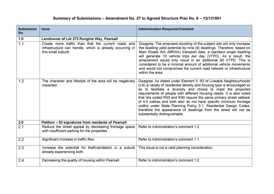
BRIEFING PAPERS
FOR ELECTED MEMBERS’
BRIEFING SESSION
Draft Only
to be held at
the Civic Centre,
Dundebar Road, Wanneroo
on 10 September, 2013 commencing at 6.00pm
BRIEFING PAPERS
FOR ELECTED MEMBERS’
BRIEFING SESSION
Draft Only
to be held at
the Civic Centre,
Dundebar Road, Wanneroo
on 10 September, 2013 commencing at 6.00pm
PROCEDURE FOR FULL COUNCIL BRIEFING
PRINCIPLES
A Council Briefing occurs a week prior to the Ordinary Council Meeting and provides an opportunity for Elected Members to ask questions and clarify issues relevant to the specific agenda items before council. The briefing is not a decision-making forum and the Council has no power to make decisions. The briefing session will not be used, except in an emergency, as a venue or forum through which to invoke the requirements of the Local Government Act 1995 and call a special meeting of Council.
In order to ensure full transparency the meetings will be open to the public to observe the process. Where matters are of a confidential nature, they will be deferred to the conclusion of the briefing and at that point, the briefing session closed to the public. The reports provided are the Officers’ professional opinions. While it is acknowledged that members may raise issues that have not been considered in the formulation of the report and recommendation, it is a basic principle that as part of the briefing sessions Elected Members cannot direct Officers to change their reports or recommendations.
PROCESS
The briefing session will commence at 6.00 pm and will be chaired by the Mayor or in his/her absence the Deputy Mayor. In the absence of both, Councillors will elect a chairperson from amongst those present. In general, Standing Orders will apply, EXCEPT THAT Members may speak more than once on any item, there is no moving or seconding items, Officers will address the members and the order of business will be as follows:-
Members of the public present may observe the process and there is an opportunity at the conclusion of the briefing for a public question time where members may ask questions (no statements) relating only to the business on the agenda. The agenda will take the form of:
Ø Attendance and Apologies
Ø Declarations of Interest
Ø Reports for discussion
Ø Tabled Items
Ø Public Question Time
Ø Closure
Where an interest is involved in relation to an item, the same procedure which applies to Ordinary Council meetings will apply. It is a breach of the City’s Code of Conduct for an interest to not be declared. The briefing will consider items on the agenda only and proceed to deal with each item as they appear. The process will be for the Mayor to call each item number in sequence and ask for questions. Where there are no questions regarding the item, the briefing will proceed to the next item.
AGENDA CONTENTS
While every endeavour is made to ensure that all items to be presented to Council at the Ordinary Council Meeting are included in the briefing papers, it should be noted that there will be occasions when, due to necessity, items will not be ready in time for the briefing session and will go straight to the Full Council agenda as a matter for decision. Further, there will be occasions when items are TABLED at the briefing rather than the full report being provided in advance. In these instances, staff will endeavour to include the item on the agenda as a late item, noting that a report will be tabled at the agenda briefing session.
AGENDA DISTRIBUTION
The Council Briefing agenda will be distributed to Elected Members on the FRIDAY prior to the Council Briefing session. Copies will be made available to the libraries and the Internet for interested members of the public. Spare briefing papers will be available at the briefing session for interested members of the public.
DEPUTATIONS
Deputations will generally not be heard prior to the Council Briefing session and are reserved for prior to the Ordinary Council meeting.
RECORD OF BRIEFING
The formal record of the Council Briefing session will be limited to notes regarding any agreed action to be taken by staff or Elected Members. No recommendations will be included and the notes will be retained for reference and are not distributed to Elected Members or the public.
LOCATION
The Council Briefing session will take place in the Council Chamber in the Civic Centre.

Briefing Papers for Tuesday 10 September, 2013
CONTENTS
Item 2_____ Apologies and Leave of Absence
Town Planning Schemes & Structure Plans
3.2 Adoption of the draft Jindee Local Structure Plan No. 84
3.3 Adoption of Amendment No. 27 to East Wanneroo Cell 4 Agreed Structure Plan No. 6
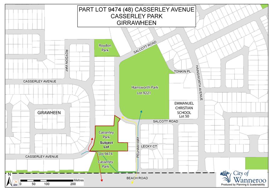
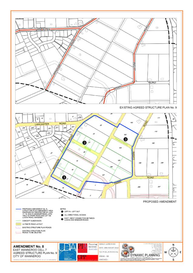
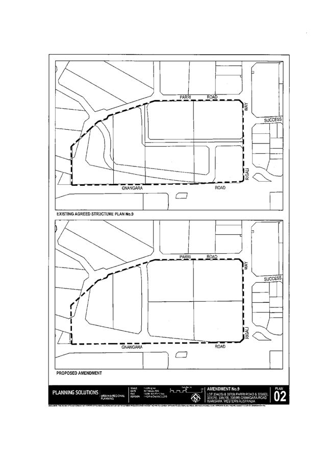
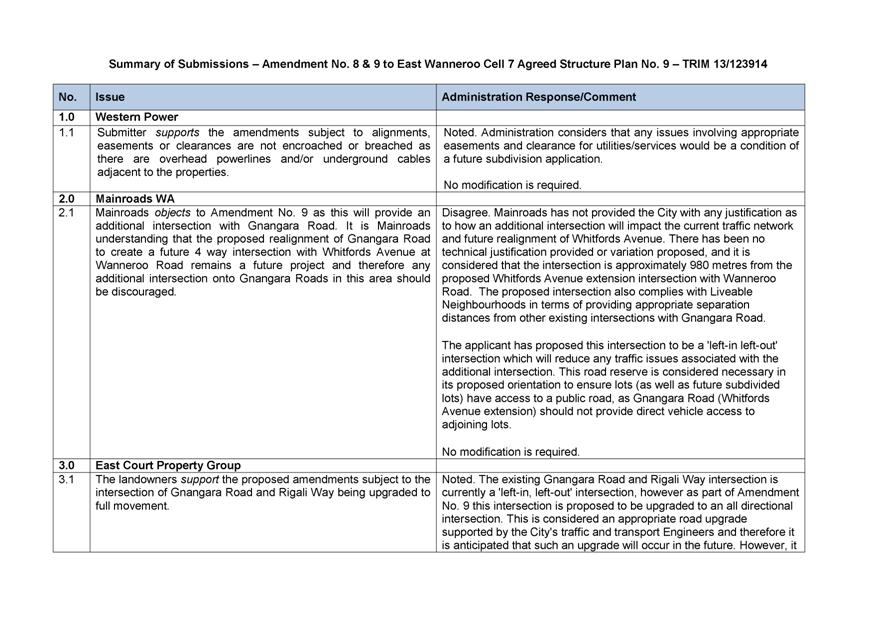
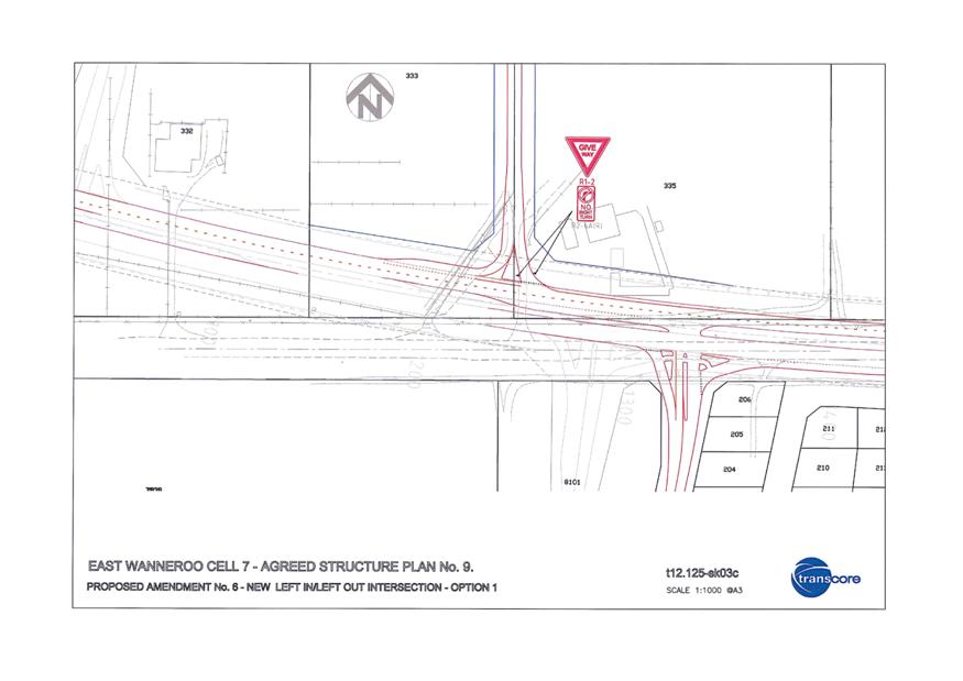
3.5 Adoption of Amendment No's 8 and 9 to East Wanneroo Cell 7 Agreed Structure Plan No. 9
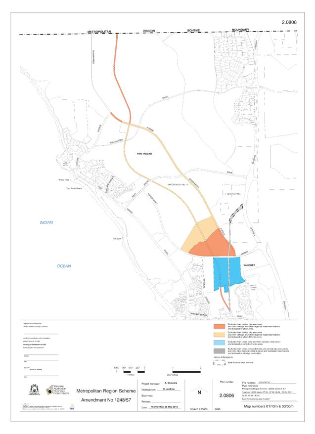
3.9 Metropolitan Region Scheme Amendment 1248/57 - Yanchep City Centre Structure Plan Area
3.10 2013/2014 Fees and Charges - Dog and Cat Registration Fees
3.13 Dedication of Lot 19 (63) Pinjar Road, Ashby
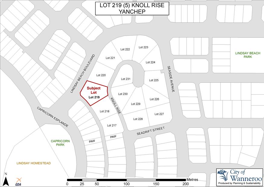
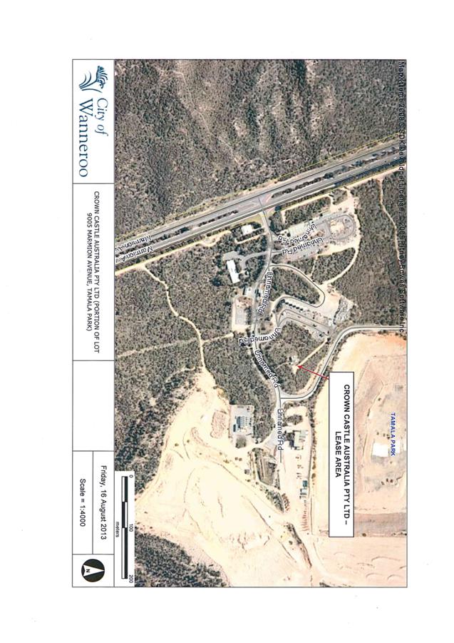
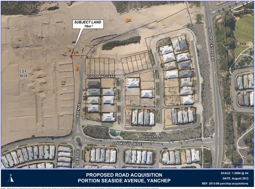
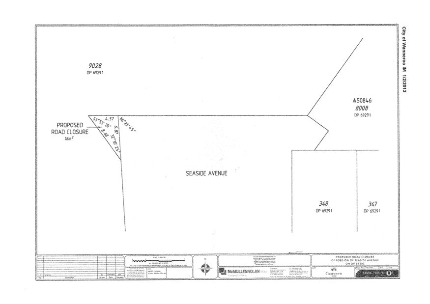
3.15 Proposed Road Closure - Portion of Seaside Avenue, Yanchep
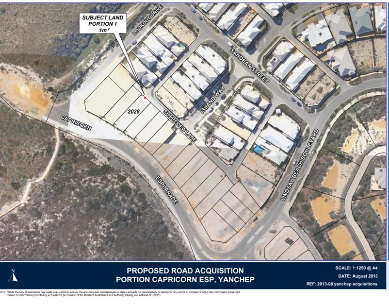
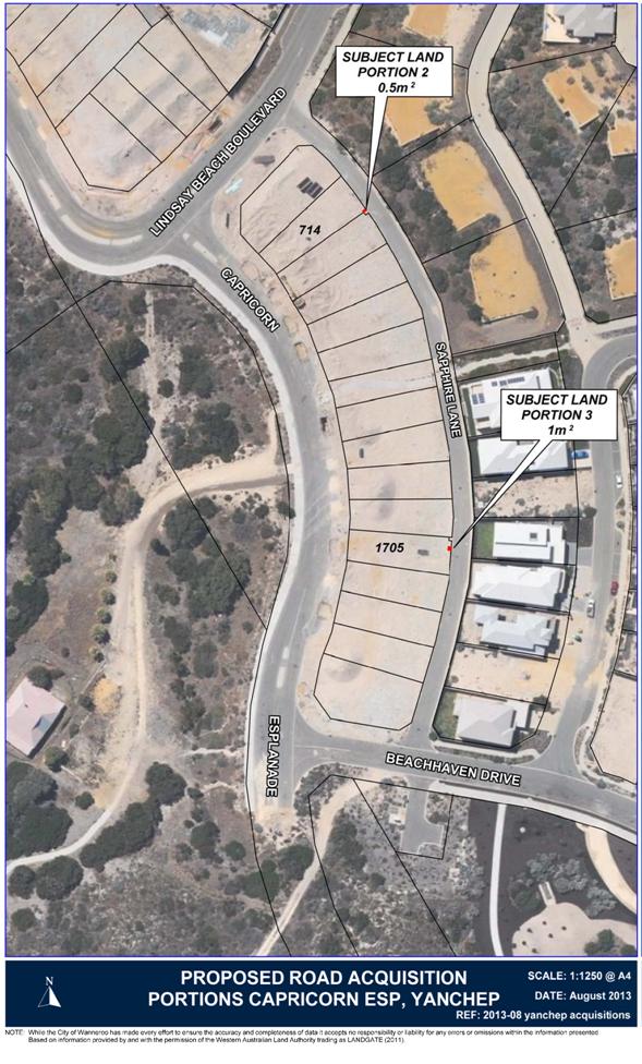
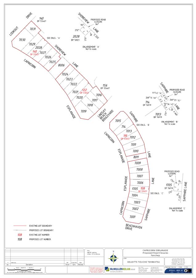
3.16 Proposed Road Closures - Portions of Sapphire Lane and Shoreview Lane, Yanchep
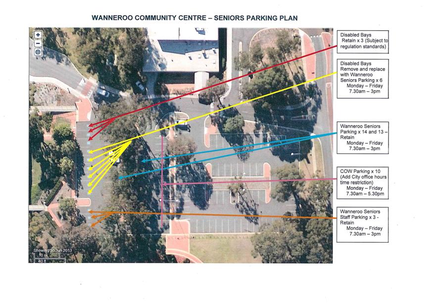
3.17 Wanneroo Community Centre - Parking Controls
3.18 PT02-04/13 - Request to Remove London Plane Trees from the Verge of Nankeen Circle, Tapping
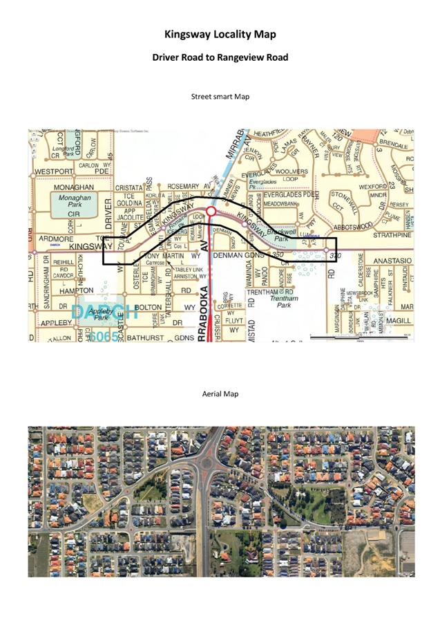
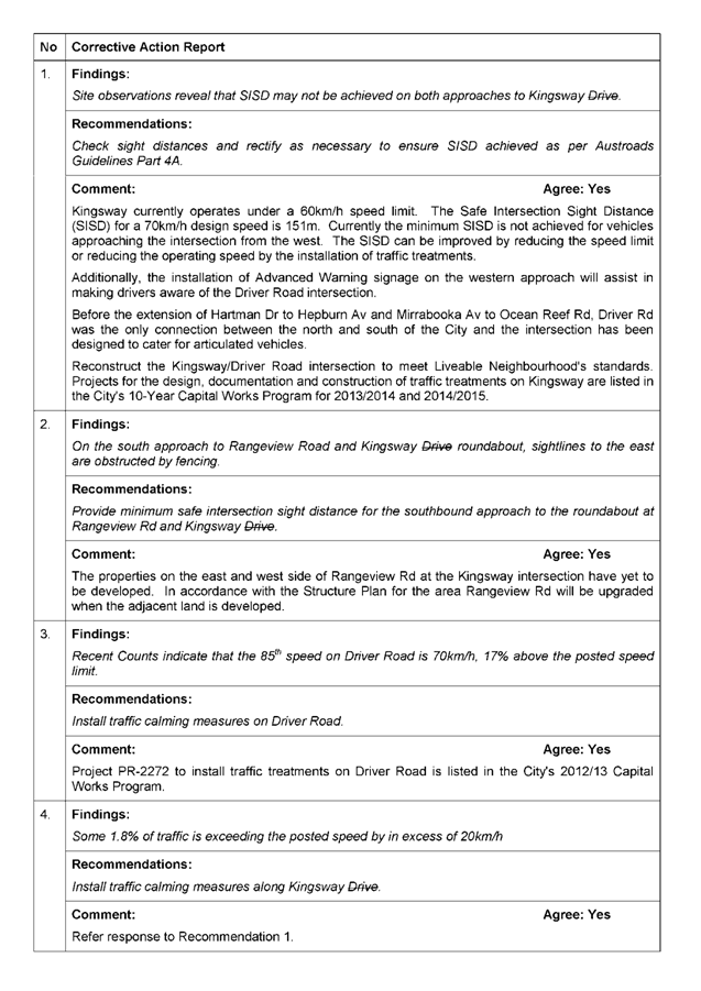
3.19 Road Safety Audit - Kingsway - Drivers Road to Rangeview Road
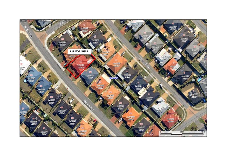
3.20 Installation of Bus Shelter at Bus Stop #21938 - Baltimore Parade, Merriwa
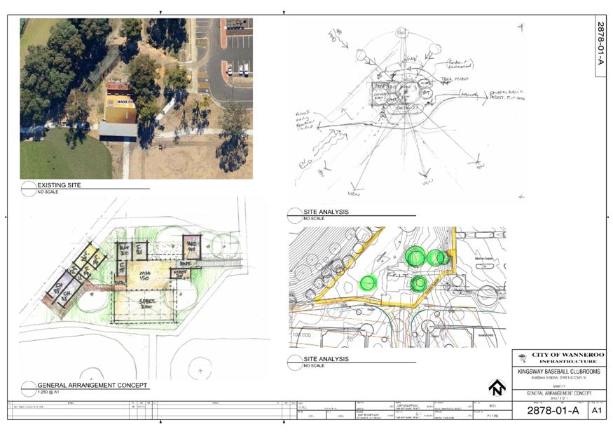
3.22 Community Facilities Sporting and Recreation Facilities Fund - 2013
3.24 Write Off Outstanding Debt - Community Facilities
3.25 Update - Tapping Community Garden
Corporate Strategy & Performance
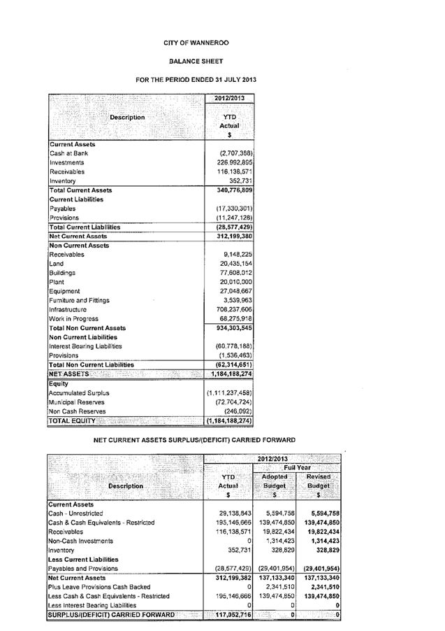
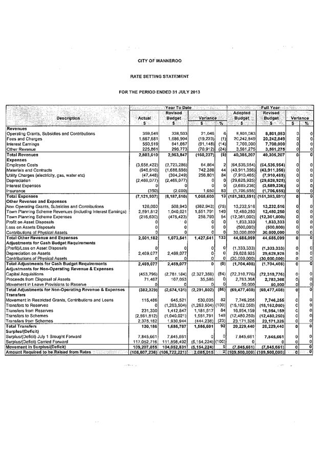
3.26 Financial Activity Statement for the Period Ended 31 July 2013
3.27 Warrant of Payments for the Period to 31 August 2013
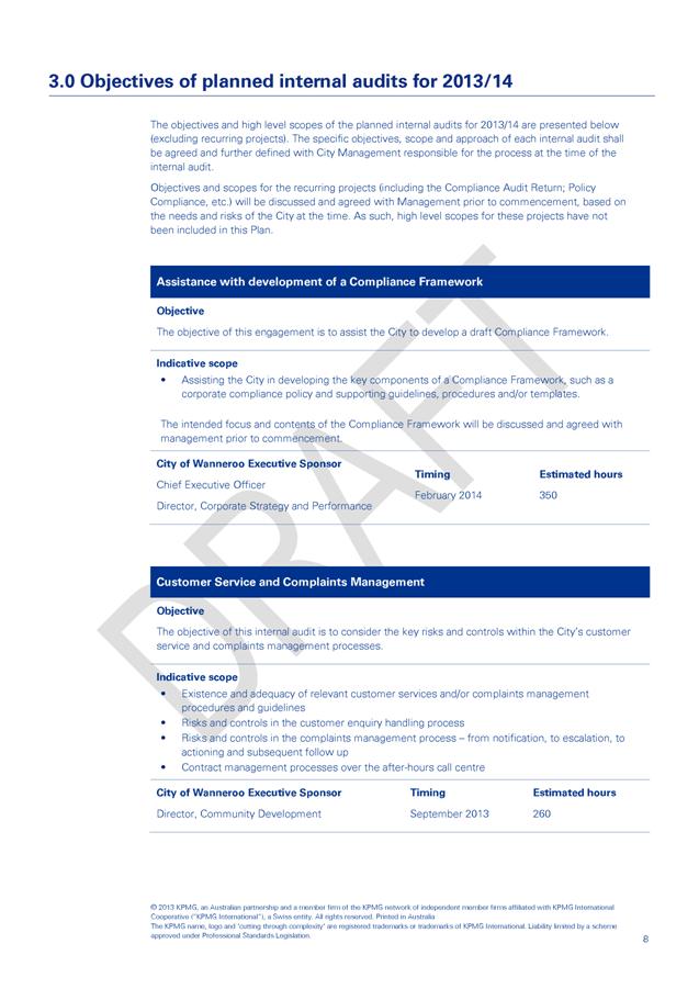
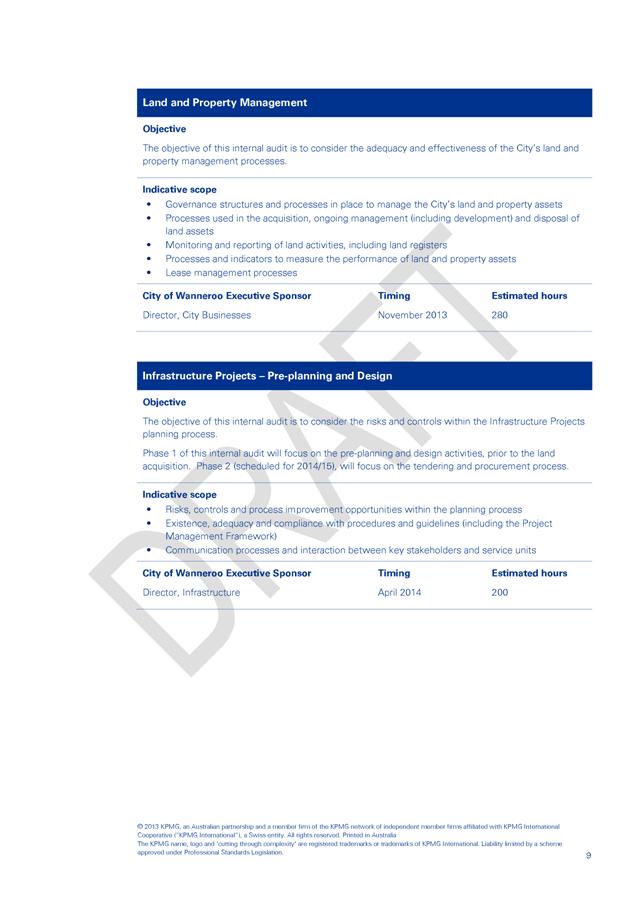
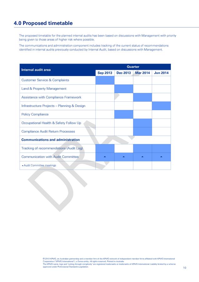
3.28 Amendments to the 2013/14 Audit Plan
3.29 Donations to be Considered by Council - September 2013
3.30 Amendments to the Adopted Council Meeting Schedule
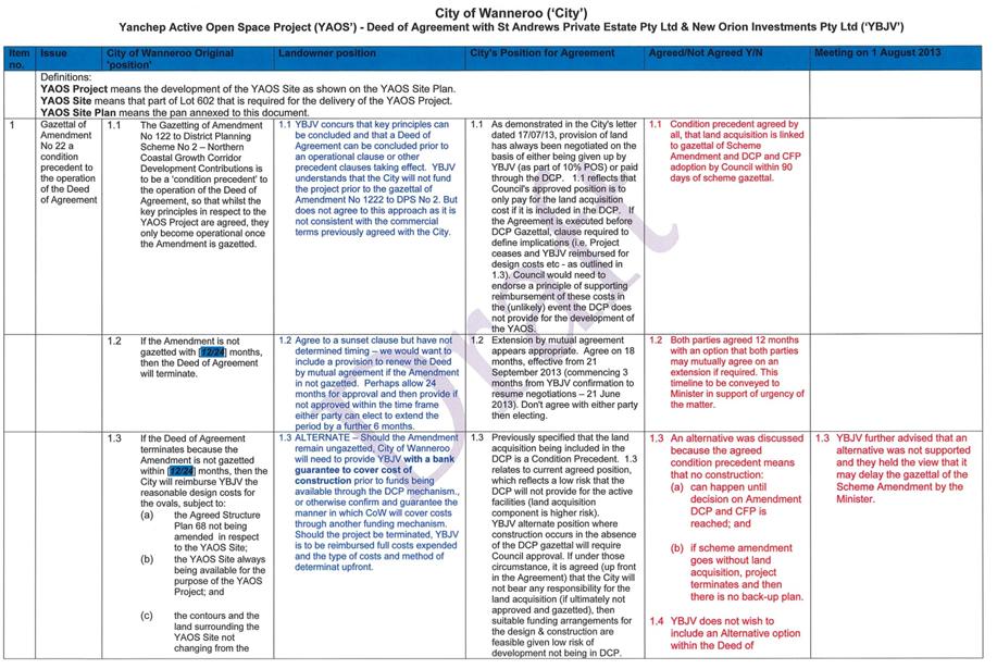
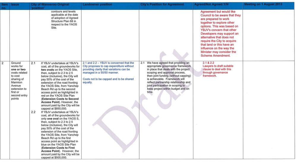
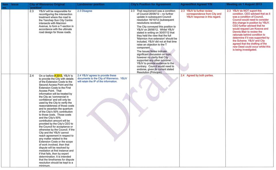
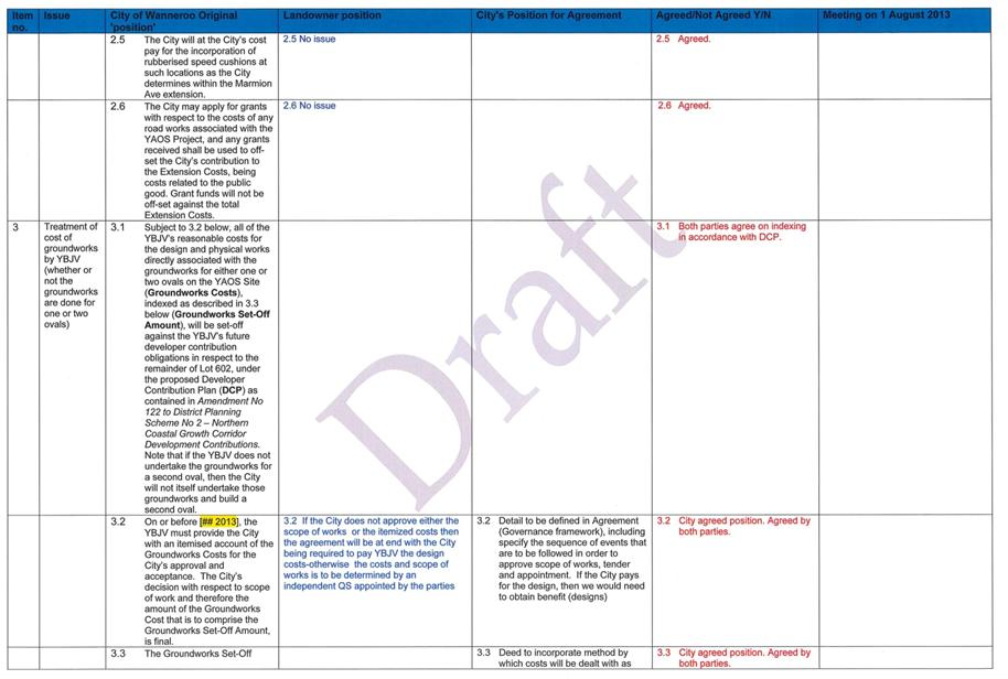
3.31 Yanchep Active Open Space - Deed of Agreement
4.2 Cr Dot Newton – Drovers Place – Installation of Speed Cushions
4.3 Cr Rudi Steffens – State Funding Dualling of Wanneroo Road
Item 5_____ To Be Tabled at the Briefing
5.1 Status Report Flynn Drive Realignment
Item 6_____ Public Question Time
7.1 Chief Executive Officer's Annual Performance Review - 2012/13
Item 8_____ Date of Next Meeting
Agenda
Item 2 Apologies and Leave of Absence
Declarations of Interest by Elected Members, including the nature and extent of the interest. Declaration of Interest forms to be completed and handed to the Chief Executive Officer.
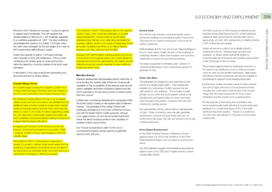
3.1 Proposed Amendment to Local Planning Policy 3.3: Northern Coastal Growth Corridor Development Contributions
File Ref: 4636 – 13/140955
Responsible Officer: Director, Planning and Sustainability
Disclosure of Interest: Nil
Attachments: 2
Issue
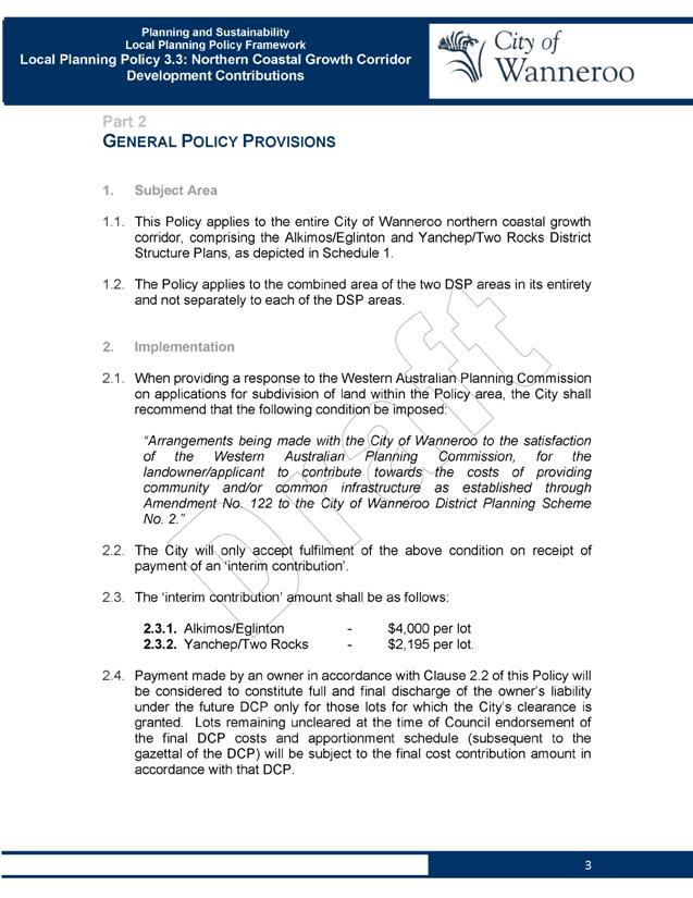
To consider initiating an amendment to Local Planning Policy 3.3: Northern Coastal Growth Corridor Development Contributions (LPP 3.3) for the purpose of public advertising.
Background
Council adopted LPP 3.3 in February 2012 (Item PS03/2013) to address the issue of development contributions in the Northern Coastal Growth Corridor (NCGC) while a Development Contribution Plan (DCP) was being prepared for the NCGC, for the purpose of collecting development contributions towards the delivery of future community facilities.
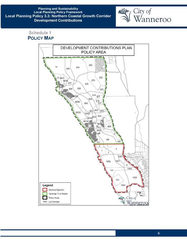
LPP 3.3 was prepared in consultation with all affected landowners in the NCGC and requires payment of the following interim development contributions, pending gazettal of a formal DCP(s) for Alkimos Eglinton and Yanchep Two Rocks:
· Alkimos Eglinton - $2,000 per lot
· Yanchep Two Rocks - $1,750 per lot
Since Council's adoption of LPP 3.3, landowners in the NCGC have been paying the interim contribution amounts specified above, at the time of seeking the City's clearance of Western Australian Planning Commission (WAPC) subdivision conditions, in order to obtain certificates of title for new residential lots. The interim contributions serve to ensure that residential development occurring in the area prior to the adoption of a formal DCP(s), still contributes towards future community facilities that will be needed in the area to cater for the needs of new residents.
Formal DCPs for Alkimos Eglinton and Yanchep Two Rocks are to be introduced into the City's District Planning Scheme No. 2 (DPS 2) by Amendment No. 122 to the Scheme.
Council resolved to grant final adoption of Amendment No.
122 at its June 2013 meeting
(Item PS03-06/13) and the amendment is now awaiting WAPC consideration and
referral to the Minister for Planning for determination.
With Council's adoption of Amendment No. 122, there is now more certainty that the ultimate contribution rates will be higher than those included in LPP 3.3. For this reason, it is recommended that the interim contribution rates prescribed by LPP 3.3 be adjusted upwards to ensure that contributions received in the meantime (pending finalisation of Amendment No. 122) more closely align with the projected contribution rates arising from Amendment No. 122. This is considered appropriate, because it is not known how long it will take the WAPC and Minister to make a final decision on Amendment No. 122. If the interim contribution rate is not adjusted in the meantime, then the City will effectively be under-collecting contributions, resulting in either a shortfall of funds to deliver the facilities in future, or imposition of a higher than expected contribution rate to recover that shortfall.
The need to amend LPP 3.3 to adjust the contribution rates was highlighted in the June 2013 report to Council on Amendment No. 122, which stated (in the 'Policy Implications' section):
"Local Planning Policy 3.3: Northern Coastal Growth Corridor Development Contributions (LPP 3.3) outlines an interim arrangement for development contributions agreed to by all landowners affected by Amendment No. 122. The interim arrangement involves the payment of cost contributions at an agreed rate per lot by land developers in the Alkimos Eglinton and Yanchep Two Rocks DCP areas, until such time as Amendment No. 122 is gazetted.
Following Council's decision on Amendment No. 122, Administration will submit a separate report to Council to consider initiating an amendment to LPP 3.3 (for the purpose of public advertising), to revise the interim development contribution rate for both DCP areas, to reflect the higher likely contribution rate to be applied when Amendment No. 122 is finally gazetted."
Detail
The proposed amendment to LPP 3.3 comprises four elements:
1. Changes to the 'Application and Purpose' section to provide more context in relation to the purpose and status of the Policy in relation to Amendment No. 122 to DPS 2.
This change simply updates the explanatory text in LPP 3.3 to include reference to Amendment No. 122.
2. Changes to the 'Implementation' section to update the recommended subdivision condition to include reference to Amendment No. 122, as per the WAPC model subdivision conditions.
3. Changes to the 'Implementation' section to update the interim contribution amount to more closely align with the costs now proposed to be implemented through Amendment No. 122.
It is proposed to change the interim cost contribution amount for Alkimos Eglinton from $2,000 per lot to $4,000 per lot; and from $1,750 per lot to $2,195 per lot for Yanchep Two Rocks, to more closely align with the cost contributions proposed in Amendment No. 122.
4. Addition of two new clauses to clarify how the Policy will apply to the redesign of previously approved subdivisions and to re-applications for lapsed subdivision approvals. This is in response to the most common query received in relation to the administration of LPP 3.3 and aims to clarify the operation of the Policy for applicants.
A 'tracked change' version of adopted LPP 3.3, showing the above amendments, is included at Attachment 1, while the 'as amended' version incorporating those amendments is included at Attachment 2.
Consultation
If agreed by Council, it is proposed to advertise the proposed amendment to LPP 3.3 for public comment for a period of 21 days in the following manner, consistent with the requirements of DPS 2:
1. Advertisement in a local newspaper for two consecutive weeks;
2. Display on the City’s website; and
3. Letters sent to relevant stakeholders, as determined by the Director Planning and Sustainability (including all developers and large parcel landowners within the NCGC).
Comment
The proposed amendment to LPP 3.3 will maintain the interim measure put in place to safeguard the City against potential lost contributions, until such time as Amendment No. 122 is finalised and the final details of the DCPs are known. Amendment No. 122 has been referred to the WAPC for adoption and Administration has met with the Minister for Planning, the Director General of the Department of Planning and the Schemes Assessment team of the Department of Planning on separate occasions in order to communicate the importance of the Amendment and push for its early consideration. Regardless, the Department's advice is that amendments of a similar nature have taken upwards of 12 months to process.
The most significant change now proposed to the Policy that will have the greatest impact on land developers in the NCGC, is the adjustment of the interim cost contribution amounts.
When LPP 3.3 was originally endorsed by Council, Amendment No. 122 had not yet been advertised for public comment, and the likely final cost contribution amounts were not able to be confirmed. The interim contribution amounts included in LPP 3.3 therefore represented a proportion of the estimated costs and were previously agreed by all affected land developers.
Even though the final cost contribution amounts will not be known until such time as Amendment No. 122 is gazetted, the adoption of Amendment No. 122 by Council at its meeting of June 2013 provided more certainty as to the likely quantum of cost contribution amounts that will be adopted following gazettal.
In the Amendment No. 122 report to Council's June 2013 meeting, the contribution rate for Alkimos Eglinton (following adoption of Amendment No. 122) was estimated at $4,600 per dwelling, while for Yanchep Two Rocks it was estimated at $2,195 per dwelling (if the Yanchep District Open Space is not acquired) or $3,312 per dwelling (if it is acquired). The revised interim contribution rates now proposed by this amendment to LPP 3.3 differ slightly from the estimated rates stated in the report to Council in June 2013, for the following reasons:
- For Alkimos Eglinton, it is proposed to apply an interim contribution rate of $4,000, instead of $4,600 as previously estimated, because it was also previously highlighted that Administration is continuing to work with Alkimos Eglinton landowners to refine the scope and cost of future facilities.
This revised interim rate is still double the existing interim rate applying to Alkimos Eglinton; is reflective of previously stated landowner expectations for a contribution rate of "around $4,000" per dwelling; and is within an acceptable margin of the likely final contribution rate, following refinement of facility scope and costs with landowners.
- For Yanchep Two Rocks, it is proposed to increase the interim contribution rate from $1,750 per dwelling to $2,195 per dwelling – an increase of only $445 per dwelling, or around 25% over the existing interim rate. This revised interim rate reflects the lower range of the estimated final contribution rate mentioned earlier (depending on whether the Yanchep District Open Space is acquired or not). This revised interim rate per dwelling is $1,117 less than the rate that would apply if the Yanchep District Open Space were to be acquired (i.e. $3,312 per dwelling). This is not expected to result in any material shortfall in Scheme funds, because the revised interim rate will only apply until shortly after gazettal of Amendment No. 122. In the meantime, subdivision in the Yanchep Two Rocks area is proceeding at a much slower rate than in Alkimos Eglinton, so 'under-collecting' is not such an immediate concern. Further, if the higher contribution rate of $3,312 per dwelling were to be applied as the new interim rate, then any contributions collected at that rate prior to gazettal of Amendment No. 122 could result in unnecessary and inequitable 'over-collections' if the acquisition of the Yanchep District Open Space is excluded from the gazetted version of Amendment No. 122.
The interim arrangement outlined in LPP 3.3 was originally put in place in recognition of the fact that developers whose subdivisions generate a need for community facilities in the area should not be exempt from making contributions just because their development timeframes are in advance of the formal DCP coming into effect.
The changes now proposed to LPP 3.3 are considered necessary to ensure that the real value of interim contributions is maintained and that the extended time taken to finalise Amendment No. 122 does not overly burden later developers with the responsibility to meet any contribution shortfall resulting from the decreased developable area.
The need to increase the value of interim contributions was raised and discussed with Alkimos Eglinton landowners as part of post-advertising consultation on Amendment No. 122. The proposal was acknowledged as being one measure to reduce the increasing financial obligation on the owners of land yet to be developed in the DCP areas, however it was acknowledged that the financial impacts of the proposal would need to be closely reviewed by all stakeholders before making formal comment. This issue has not been discussed previously with Yanchep Two Rocks landowners, however the proposed increase to the interim contribution rate for that area is considered minimal.
Within 90 days following gazettal of Amendment No. 122, Council must adopt the final Community Facilities Plan and DCPs for Alkimos Eglinton and Yanchep Two Rocks. Once that occurs, the final cost contribution rates will be established and LPP 3.3 will therefore no longer be required and is intended to be revoked.
Statutory Compliance
In accordance with Clause 8.11.3.3 of DPS 2, the process for amending a Local Planning Policy is the same as for the preparation of a new policy. A draft policy (or proposed amendment) must be advertised for public comment for a period of not less than 21 days, after which time it is to be reviewed in the context of any submissions received and either adopted with or without modifications or not proceeded with. It is proposed to advertise LPP 3.3 for a period of 21 days, which is consistent with the requirements of DPS 2.
Strategic Implications
The proposal aligns with the following objective within the Strategic Community Plan 2013 – 2023:
“2 Society - Healthy, safe, vibrant and active communities.
2.1 Great Places and Quality Lifestyle - People from different cultures find Wanneroo an exciting place to live with quality facilities and services.”
Policy Implications
LPP 3.3 is an existing local planning policy and forms part of the City's Local Planning Policy Framework. It is being reviewed out of necessity, ahead of the scheduled review in 2014.
Administration intends to revoke LPP 3.3 following the gazettal of Amendment No. 122 as the mechanisms to administer the development contributions in the Alkimos Eglinton and Yanchep Two Rocks areas will be incorporated in DPS 2 and the two respective DCPs.
Financial Implications
The proposed amendment to LPP 3.3 aims to (among other changes) increase the value of interim cost contributions made towards future community facilities in the NCGC. Interim contributions are held in an appropriate reserve account and will only be used for the purposes outlined in Amendment No. 122 following gazettal of that amendment.
The reserve account for Alkimos Eglinton currently contains $2.158 million dollars in collected contributions, while the Yanchep Two Rocks reserve account contains $227,500 in collected contributions. These figures exclude interest earnings on the accounts.
Voting Requirements
Simple Majority
That Council pursuant to Clause 8.11.3.1(a) of District Planning Scheme No. 2 ADVERTISES the proposed amendment to Local Planning Policy 3.3: Northern Coastal Growth Corridor Development Contributions, as contained in Attachment 2, for public comment for a period of 21 days, by way of:
1. Advertisements in the local newspapers circulating in the affected area for two consecutive weeks;
2. Display on the City's website; and
3. Letters sent to relevant stakeholders, as determined by the Director Planning and Sustainability.
Attachments:
|
1View. |
Attachment 1 - Amendment 1 to LPP 3.3 (tracked changes) |
13/144242 |
|
|
2View. |
Attachment 2 - Amendment 1 to LPP 3.3 (as amended) |
13/147256 |
Minuted |
CITY OF WANNEROO Agenda OF Elected Members' Briefing Session 10 September, 2013 18

Town Planning Schemes & Structure Plans
File Ref: 5332 – 13/41693
Responsible Officer: Director, Planning and Sustainability
Disclosure of Interest: Nil
Attachments: 6
Issue
To consider submissions on the proposed Jindee Local Structure Plan No. 84 (LSP 84) to determine the modifications required and its acceptability for final approval and forwarding to the Western Australian Planning Commission (WAPC) for endorsement.
|
Applicant |
Roberts Day |
|
Owner |
Westminster Estates Property Limited |
|
Location |
Lot 9036 Marmion Avenue, Jindalee and part Lot 3054 Marmion Avenue Jindalee |
|
Site Area |
124.38 hectares |
|
MRS Zoning |
Urban and Parks and Recreation |
|
DPS 2 Zoning |
Smart Growth Community |
Background
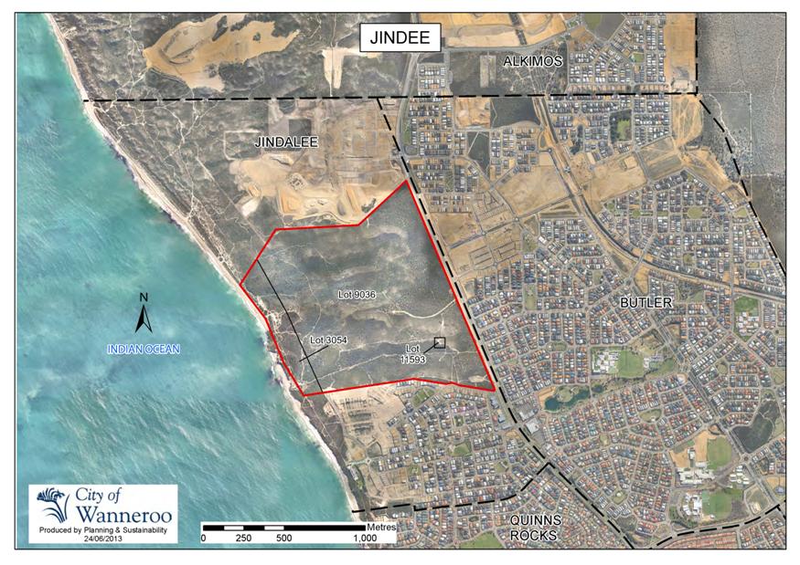
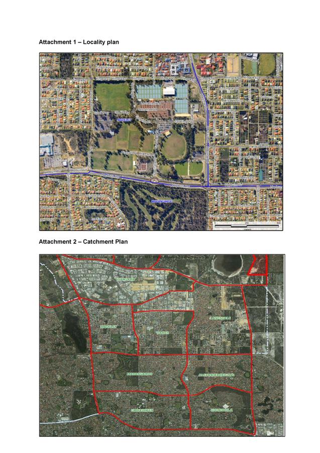
On 28 June 2012, Roberts Day, on behalf of Estates Development Company (the landowner), submitted LSP 84 to the City for assessment and consideration. The proposed Structure Plan falls within the wider Butler-Jindalee District Structure Plan (DSP) area and is generally bounded by Marmion Avenue to the east, the Agreed Local Structure Plan No. 36 - Lot 12 Marmion Avenue to the south, Regional Parks and Recreation foreshore reserve to the west and Lot 9 Marmion Avenue to the north. A plan showing the location of the LSP 84 area is included as Attachment 1.
In 2007 the City entered into the Jindee Innovation Project Agreement with the WAPC and the landowner, to facilitate the exchange of the foreshore land (portion of Lot 3054) for land located within Lot 9036. Through the Innovation Agreement, the parties agreed to pursue Jindee as a Smart Growth Strategy demonstration project for the City, using a transect model to regulate planning and development of the land. The Agreement was a precursor to Amendment No. 115 to District Planning Scheme No. 2 (DPS 2) – Jindee Smart Growth Community, and MRS amendment 1152/41.
The submission of LSP 84 follows Council's decision of 13 November 2012 to adopt Amendment No. 115 to DPS 2. The purpose of Amendment No. 115 was to introduce a new ‘Smart Growth Community’ zone into DPS 2 together with corresponding provisions that set out the objectives, standards and requirements applicable to that zone; rezone the subject land to 'Smart Growth Community' zone; and to require a Local Structure Plan to be prepared and agreed by Council as a prerequisite to any subdivision or development within the Smart Growth Community zone. Amendment No. 115 to DPS 2 has now been endorsed by the Minister of Planning and was gazetted on 23 July 2013. LSP 84 has been prepared to fulfil the final requirements of Amendment No. 115 and facilitate subdivision and development of the Jindee 'Smart Growth Community' zone. Amendment No. 115 introduced provisions to DPS 2 whereby local planning policies do not apply to the LSP 84 area unless specifically stated in an adopted policy.
LSP 84 utilises a 'Transect Based Code' that is derived from SmartCode® as the planning framework for the subdivision and development of the LSP 84 area.
In addition to addressing the conventional elements such as land use, neighbourhood structure and subdivision layout ordinarily contained within structure plans, LSP 84 includes controls to regulate the design of buildings, the landscape and thoroughfares. The Jindee Design Code is included as Schedule 1 to the Part 1 statutory provisions, and contains detailed design standards relating to built form, thoroughfare design and landscaping. An overview of these standards will be provided later in this report.
On 24 December 2012, the Director, Planning and Sustainability forwarded a memorandum to all Elected Members advising of his intention to advertise LSP 84 under delegated authority and provided the opportunity for Elected Members to request the matter be referred to Council for consideration of consent to advertise prior to 11 January 2013. No such requests were received, therefore, advertising of LSP 84 commenced on 22 January 2013. The advertised LSP documentation for Part 1 is included as Attachment 2. Schedule 1 to Part 1 (Jindee Design Code) was also advertised for public comment and has been made available to Elected Members electronically. A full copy of Part 1 of LSP 84 (including the Jindee Design Code) is available for public viewing on the City's website.
Detail
Site
The Jindee LSP 84 area applies to Lots 9036 (2469) and 3054 (2469L) Marmion Avenue, Jindalee. The site is approximately 124 hectares and is now zoned as 'Smart Growth Community' under the DPS 2. In the southwest and southeast of the LSP 84 boundaries there are two large areas totally 6.1 hectares in size which are reserved for 'Parks and Recreation' under the Metropolitan Region Scheme (MRS). These two reserves were created through MRS amendment 1152/41 due to the high ecological significance of the two sites. Amendment 1152/41 also saw the rezoning of a portion of the foreshore reserve to 'Urban' in exchange for these two inland reserves.
Also depicted within the LSP 84 boundary is the Jindalee Primary School site adjacent to the southeast MRS reserve. The Jindalee Primary School site is reserved for 'Public Use' under DPS 2, and although the site is shown within the boundaries of LSP 84, it is subject to the provisions of Agreed Structure Plan No. 71 Jindalee Primary School and will not be subject to the LSP 84 provisions. Subdivision of the Jindalee Primary School site and the adjacent road network was approved in 2012 through subdivision application 145827. The entire LSP 84 site is currently vacant, unutilised land and, with the exception of boundary fences, there are no existing structures on the site.
Proposal
The draft LSP 84, included as Attachment 2, has been prepared to provide the broad planning framework for the Jindee Smart Growth Community zone under DPS 2.
The LSP provides the framework for the creation of the following:
· A predominately residential development incorporating 5 transect zones, as described below:
o T2 Natural Living – low density residential area consisting of larger lots (minimum size of 600m2) retaining natural landscape features such as vegetation or topography;
o T3 Sub Urban – low density residential area consisting of medium to larger sized lots accommodating dwellings and landscaped gardens;
o T4 General Urban – medium density residential area consisting of a mix of housing types including detached dwellings, small apartment buildings and scattered commercial activity;
o T5 Urban Centre – higher density residential area consisting of shops mixed with townhouses, offices and civic buildings with predominantly attached buildings, trees within thoroughfare reserves and substantial pedestrian activity; and
o T6 Urban Core – Medium to high density mixed use buildings for a range of uses with trees within thoroughfare reserves and the highest level of pedestrian and transit activity;
· Approximately 11.6 hectares (11.6%) of public open space;
· Approximately 2.1 hectares (2.1%) of conservation open space; and
· A range of landscaped 'civic spaces' which will be delivered as public open space (POS), pedestrian access ways or widened road verges and medians.
The 'Transect Based Code' approach to planning
As Council is aware, the approach to planning proposed by LSP 84 differs to the conventional approach ordinarily followed by the City. The major difference is the application of Transect zones over land as a means of development and density control, in lieu of the traditional density code (R-Code) applied through the Residential Design Codes and land use permissibility administered through DPS 2. Amendment No. 115 inserted provisions into DPS 2 requiring the application of the Transect Based Code (the Jindee Design Code in this instance) within the Smart Growth Community zone to "provide a framework for the application of a comprehensive Transect Based Code to facilitate the orderly planning and development of land" and to "regulate land use and coordinate the design of buildings, thoroughfares and civic spaces to promote development that adheres to the principles of the Transect".
Whilst using the 'Transect Based' and conventional approach to planning will both deliver urban settlements of varying densities and land uses, it is the inclusion of the detailed design standards contained within the Jindee Design Code which will ultimately define the development within the LSP 84 area as unique. The Jindee Design Code prescribes specific development standards for the design of buildings, thoroughfares and landscape across each Transect which will be used to assess applications for subdivision and development. This is a direct contrast from more conventional planning approaches whereby applications for subdivision are made to the WAPC often in the absence of, or prior to the approval of any detailed design standards pertaining to subsequent development of the land. Furthermore, this is a departure to the City's conventional approach where applications are normally assessed against the more generic R-Codes and relevant Local Planning Policies, which do not provide the detailed design standards provided in the Jindee Design Code. The departure from the use of the conventional assessment tools is supported by Amendment No. 115, which inserted provisions into DPS 2 stating that the R-Codes and local planning policies do not apply to land within the LSP 84 area (unless specifically stated within an adopted local planning policy).
Administration supports the fundamental principles of the Transect-Based Code approach to planning, however, it is the issue of retrofitting the Transect-Based Code to a conventional Structure Plan format that is suitable for implementation by the City which is the source of many of the issues outlined within the comments section of this report.
Consultation
The draft LSP was advertised for public comment for a period of 42 days by means of an on-site sign, an advertisement in the Wanneroo Times newspaper, the City’s website and letters written to adjoining landowners. The submission period closed on 5 March 2013 with ten submissions received. A summary of submissions received and Administration's responses are shown in Attachment 3.
Administration also undertook its assessment of the proposal during the advertising period and is recommending a number of modifications to LSP 84 as a result of this assessment. These modifications are presented in Attachment 4 and are additional to the modifications recommended in Attachment 3.
The main issues raised during the advertising period and following detailed assessment by Administration relate to:
· The subdivision process;
· Density control in the absence of the Residential Design Codes;
· POS and civic spaces;
· Marmion Avenue – capacity and future access;
· Cost contribution towards Marmion Avenue; and
· The Jindee Design Code as an assessment tool.
A more detailed discussion of the major issues considered in the assessment of LSP 84 is provided in the Comment section.
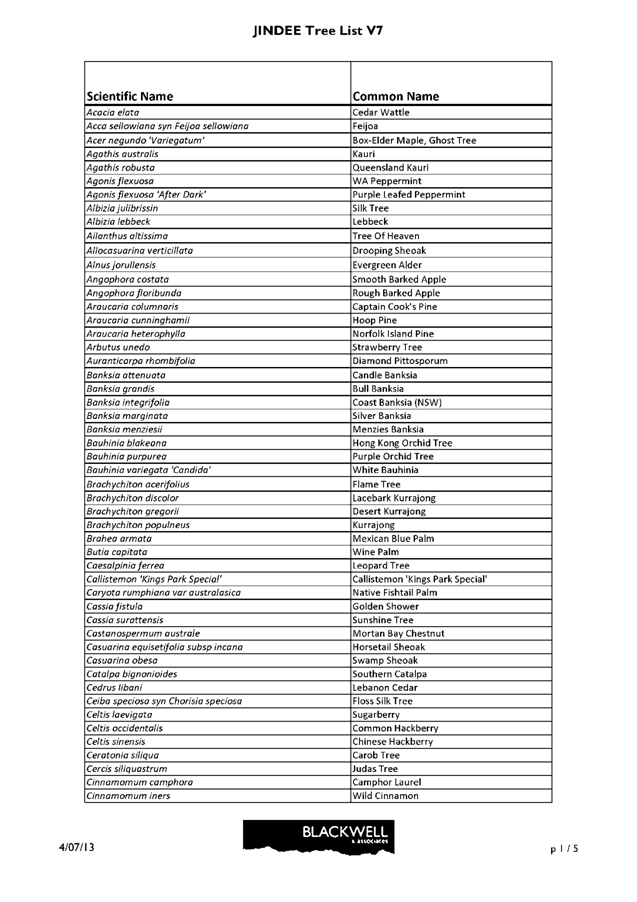
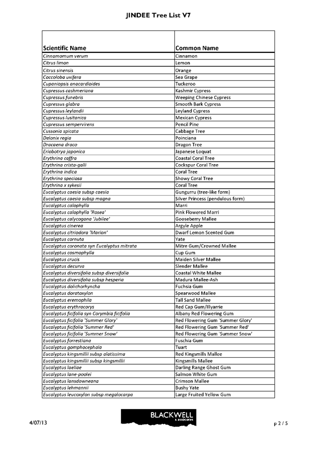
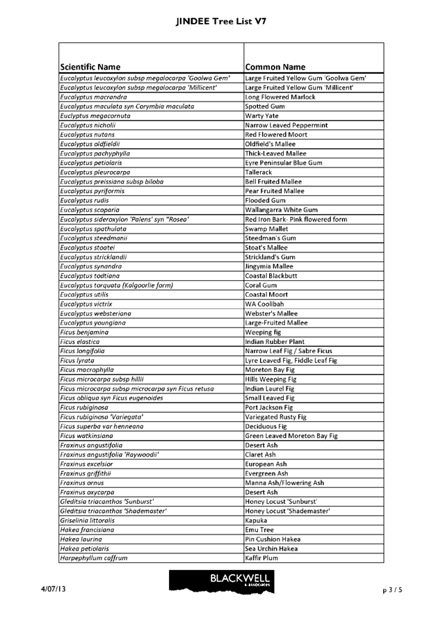
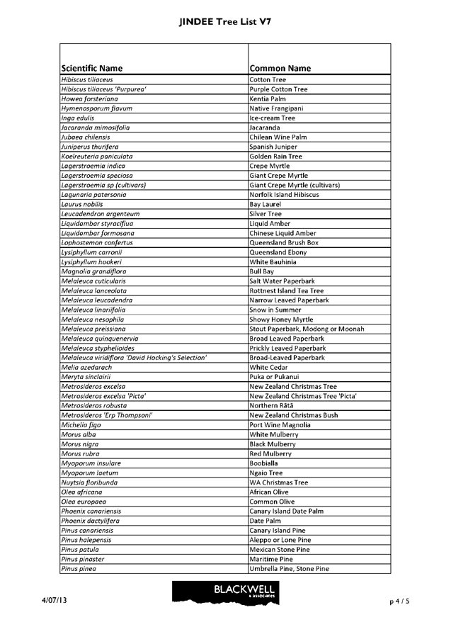
Administration's comment relating to Submission 9 of Attachment 3 refers to two replacement pages for Part 2 of LSP 84, these two replacement pages are included as Attachment 5 to this report. Recommended modification No. 123 of Attachment 4 makes reference to a modified tree list, which is included as Attachment 6.
Comment
Subdivision process
Ordinarily, the WAPC and the City have regard for the same documents when considering applications for subdivision, however, the WAPC will not be adopting or administering the Jindee Design Code and therefore will not have regard for its provisions in its assessment of applications for subdivision within the LSP 84 area. The WAPC will primarily assess applications for subdivision against the Part 1 statutory provisions of LSP 84 and Liveable Neighbourhoods. In contrast, the City will consider the Jindee Design Code in addition to the Part 1 statutory provisions when making recommendations on applications for subdivision to the WAPC.
The Department of Planning has expressed concern to Administration that this approach may have the potential to fetter their decision making powers, as the Jindee Design Code includes detailed design standards for subdivisional related issues which may differ from the standards of the Liveable Neighbourhoods Policy. This may result in the City's recommendations on an application for subdivision not aligning with the WAPC's position, due to the use of differing assessment tools by each organisation. Administration shares this concern, and consequentially is recommending a modification to LSP 84 requiring three additional plans to be introduced to the Part 1 statutory provisions which will be adopted and administered by the WAPC. The three additional plans will provide relevant details on thoroughfares, lot size ranges and public open space. Inclusion of these plans would result in some of the key design standards, currently only contained within the Jindee Design Code, being within the Part 1 statutory provisions.
Density control in the absence of the Residential Design Codes
In conventional structure plans, density is controlled by the R-Code (density code) applicable to land, with minimum and average lot sizes for each R-Code prescribed through the Residential Design Codes (R-Codes). The land within the LSP 84 area is zoned 'Smart Growth Community' which utilises a Transect Based Code in lieu of the R-Code, as a means of controlling density.
The Transect Based Code introduces 'Transect Zones', and Part 1 of LSP 84 defines lot size ranges which apply to each Transect zone. The lot size ranges for each Transect zone are extremely broad, with several Transect zones having no maximum lot size, and the minimum lot sizes across some Transects do not differ. Consequentially, residential density within LSP 84 is less regulated in comparison to other structure plans.
LSP 84 states subdivision will achieve a minimum average density of 22 dwellings per gross hectare across the LSP area, however it is difficult to ascertain an exact target density due to the flexible approach to subdivision. A fundamental principle of the Transect Based Code is to enable a flexible approach to subdivision, and the intent of such broad lot size ranges is to allow for flexibility and variation to the type of built form which can occur. Notwithstanding this, Administration has recommended a modification to include dwelling targets for each transect into the Part 1 statutory provisions to provide a measure to consider density against the intended character and intensity of development within each transect zone.
The Jindee Design Code contains detailed urban standards which control the type of development permitted on a lot. Whilst the minimum lot size across the T3 – T6 transects is 180m2, the type of building permitted and density is ultimately controlled through the typology plan contained within the urban standards of the Jindee Design Code. Each building typology across each transect is required to meet the lot areas defined within the urban standards. For example, if a 180m2 lot was created within the T3 transect, the only building typology permitted on this size lot would be a cottage which is a single family residential building. Should a developer wish to construct an apartment house (multi-family residential building) within the T3 transect, the lot would be required to be between 450m2 to 1,500m2, whereas in a T4 transect an apartment house would only be permitted on a lot ranging between 600m2 to 1,000m2. The lot sizes approved through the subdivision process will ultimately determine the type of building which will be permitted, and the density proposed.
Public open space and civic spaces
LSP 84 currently proposes 11.6% of POS, however, it is noted that a number of the proposed POS sites shown on the public space plan will not be reserved for recreation through the subdivision process as they fall within a road reserve or may become a public accessway. These spaces are considered 'civic spaces', which are outdoor areas that are available for public use. 'Civic Spaces' may or may not be POS. Administration has recommended a modification to require that only those sites which will be ultimately reserved for recreation through the subdivision process be referred to as POS throughout the text and plans of LSP 84. In addition, a modification has been recommended requiring a minimum of 10% of the gross subdivisible area, as prescribed by Liveable Neighbourhoods, is reserved through the subdivision process for recreational purposes.
Liveable Neighbourhoods provides a flexible approach to the types and sizes of POS which can be created through the subdivision process. LSP 84 proposes POS sites ranging from small spaces to larger neighbourhood parks, arranged to be compatible with the urban intensity and character of the surrounding development. In entering into the Jindee Innovation Agreement with the landowner, the City acknowledged the unique nature of the Jindee development. In particular, the provision of small, intimate spaces in the public realm, in addition to the larger POS sites ordinarily encouraged by the City (generally 5,000m2 in accordance with Local Planning Policy 4.3 - Public Open Space). Administration is confident that the POS proposed by LSP 84 will provide a variety of functional spaces, which can be used for a range of recreation purposes.
Administration acknowledges that by virtue of the varying sizes of 'Civic Spaces' proposed by LSP 84 that the cost of maintenance could be greater than what is ordinarily provided by the City.
In this regard, Administration has recommended a modification requiring the proponent to submit an Asset Management Plan for approval by the City, prior to clearance of the first subdivision. This Asset Management Plan will holistically consider the ongoing maintenance costs and funding sources for the ongoing management and maintenance of 'Civic Spaces'.
Liveable Neighbourhoods allows for 2% of the POS to be allocated for restricted use POS, which could include areas set aside for conservation. Administration considers that conservation POS is important to retain significant indigenous flora and fauna and to facilitate public access for passive recreational purposes. Currently, LSP 84 does not include specific provision for conservation POS, however, Administration has raised this issue with the proponent who has demonstrated they can provide 2.1% conservation open space, across three sites upon which they are required to retain vegetation in accordance with their approval under the Environment Protection and Biodiversity Conservation Act (EPBC Act). Accordingly, Administration has recommended a modification to require the provision of 2.1% conservation open space as agreed with the proponent.
It is pertinent to note that, in addition to the conservation open space which will be provided in accordance with the recommended modification, the proponent is also required to retain a minimum of 75% of existing vegetation across two additional POS sites through their EPBC Act approval. This equates to existing vegetation being retained on approximately an additional 0.5% of the gross subdivisible area. These sites have not been included within the conservation space area identified above, due to their restricted size, shape, location and questionable viability. In addition, LSP 84 proposes a large area of 'T2' lots strategically located between the two MRS reserves on which development will be restricted to 30% of the lot area in order to ensure the retention of high quality vegetation on the lots. The retention of high quality vegetation within the coastal foreshore reserve has been further facilitated as a result of the regional beach parking for the Jindee coastal area being integrated into the design of the coastal village (visible on the Plan 1 of Attachment 2) in contrast to many developments where regional beach parking is provided in the foreshore reserve. In this regard, Administration is satisfied that LSP 84 provides adequate conservation areas to ensure the retention of significant indigenous flora and fauna.
Marmion Avenue – capacity and proposed access
Main Roads Western Australia (MRWA) identified several concerns with LSP 84, in particular the capacity of Marmion Avenue and the future access points proposed by LSP 84. MRWA requested a revised updated Traffic Impact Assessment to be undertaken including Regional Operations Modelling (ROM) and SIDRA analysis for all major signalised and unsignalised intersections accessing Marmion Avenue. Furthermore, MRWA was of the view the traffic modelling should take into account the higher short term traffic volumes on Marmion Avenue resulting from the staged interim construction of the Mitchell Freeway. MRWA also advised it did not support the two proposed left in/left out intersections located 150 metres to the south, and 150 metres to the north of the traffic signals at Butler Boulevard.
Administration agrees that revised traffic modelling is necessary, however, considers the appropriate model to be the North West Corridor Ultimate Development PM Peak Hour Traffic Model (NWC Model), rather than Main Roads current 2031 ROM data. The NWC model was developed by traffic engineering consultant Bruce Aulabaugh in cooperation with the City, and provides ultimate development traffic forecasts for the area north of Hester Avenue, south of the Two Rocks boundary, east of the coast and west of Old Yanchep Road. The NWC model has been used in the assessment and approval of other structure plans in the north-west corridor, and no requirements have been placed on these structure plans to incorporate 2031 ROM data. Administration does not support MRWA's request for the modelling to incorporate the higher short term traffic volumes on Marmion Avenue due to the staged interim construction of the freeway, this type of strategic modelling should be undertaken by MRWA and should not be the sole burden of one land owner within the north-west corridor.
Notwithstanding this, Administration does consider that LSP 84 should address the long term traffic generation of the LSP 84 area and its impact on and from the immediate surrounding road network.
LSP 84 depicts four full movement intersections for local roads with Marmion Avenue, and two left in/left out access points, all of which are consistent with the City's Local Planning Policy 3.8 Marmion Avenue Arterial Road Access (LPP 3.8). MRWA has indicated they do not support the two proposed left in/left out intersections on Marmion Avenue due to their close proximity to signals approximately 150 metres to the north and south. Administration considers that the location of future access points should be compliant with LPP 3.8 to ensure consistency of Marmion Avenue access throughout the north-west corridor. LPP 3.8 is a strategic policy which has guided the City's decisions regarding Marmion Avenue since its adoption in February 2012 and Administration is of the view access to the LSP 84 area should be in accordance with such.
Cost contribution to Marmion Avenue
There is an obligation under Part 11 and Schedule 10 of DPS 2 for the landowner to make a contribution towards the cost of construction of Marmion Avenue. Currently, LSP 84 makes no reference to this obligation, therefore, Administration has recommended a modification to require the Part 1 statutory provisions be updated to state that contributions are payable in accordance with the 'Clarkson Butler District Distributor Road (DDR) Infrastructure Developer Contribution Arrangements'.
The section of Marmion Avenue abutting the LSP 84 area was constructed approximately five years ago by Capricorn Village Joint Venture (CVJV). In the past, the City has received requests from CVJV, seeking the City's commitment to transfer any development contribution funds collected from the Jindee development on Lot 9036 and Pt Lot 3054 to CVJV, as reimbursement for CVJV's prefunding of Marmion Avenue.
CVJV's request is considered reasonable and is supported by Administration, because DPS 2 has not borne the cost of constructing Marmion Avenue to its current standard – that was done at the expense of CVJV. That does not mean the Scheme contribution for Marmion Avenue should be erased though, and that landowners who have not yet developed (such as Westminster Estates Property Limited) should avoid paying their equitable and proportionate contribution towards the construction of that road, whether that was paid for by the Scheme or by another developer. The fact remains that the Scheme requires contributions to be collected from all developers in the area for the construction of Marmion Avenue. On that basis, the City to collect those contributions even though it did not incur the cost of constructing Marmion Avenue in its current form. However, that is not considered fair and reasonable or in the spirit of fairness and equity. As such, Administration has recommended that Council agrees 'in principle' to forward the future contribution paid for LSP 84 for Marmion Avenue to CVJV, once it has been received by the City.
The Jindee Design Code
As previously identified, the Jindee Design Code is essentially a set of standards which will be utilised by the City during the subdivision and development assessment processes. The Jindee Design Code standards and controls are modelled on SmartCode®, which is intended to be locally calibrated to facilitate site specific development rather than a one size fits all approach. The introduction to the Jindee Design Code contains a series of tables which outline the design parameters and form the basis for specific design requirements and controls outlined in the regulating plan series, urban standards, thoroughfare standards and landscape standards. The City will use the Jindee Design Code in addition to the Part 1 statutory provisions to assess subdivision applications and detailed area plans.
The Jindee Design Code sits as a 'Schedule 1' to Part 1 of LSP 84 and will be adopted by the City along with the substantive Structure Plan. Below is a summary and comments on each element contained within the Jindee Design Code.
Regulating Plan Series
The regulating plan series consists of three plans which guide the design controls over land and development within the LSP 84 area. The Transect Plan identifies the Transects and reserves within the LSP 84 area. The Control Plan identifies specific locations for required and recommended design elements within the LSP 84 area, such as frontage types, thoroughfare types and design responses. The Public Open Space Plan identifies those areas which will ultimately be reserved for recreation through the subdivision process and those areas which will be considered conservation open space. As the Department of Planning will not be implementing any part of the Jindee Design Code, Administration has concerns about elements of the regulating plan series that related to the subdivision design. As outlined above, however, modifications have been recommended requiring three plans to be inserted into Part 1 of LSP 84 which duplicate much of this subdivision related design material. Administration is now satisfied with the content of the Regulating Plan Series and its role in guiding the design of the LSP 84 area.
Urban Standards
The urban standards provide guidelines on the future built form within the LSP 84 area, and address elements such as building types, building disposition, setbacks and parking arrangements. The standards are comprehensive and seek to regulate those aspects of private buildings which affect the public realm across the transect zones. Administration's key concern with the Urban Standards relates to the proposed car parking standards which are considered to be overly complicated and in many instances overly flexible. Although LSP 84 proposes a different style of development which is anticipated to be more accessible by other modes of transport, it is still necessary for adequate car parking to be provided in village centres and for land uses which attract a large number of people who will travel by car. Administration's recommended modifications 88 - 100 of Attachment 4 largely relate to this issue and seek to ensure a reasonable medium is achieved.
Thoroughfare Standards
The thoroughfare standards contain detailed design and engineering standards for vehicular and pedestrian way typologies. The thoroughfare standards outline elements including the minimum reserve width, design speed and intended form of traffic flow and aim to provide a responsive approach to the transect in which they are located to contribute to the desired character of the transect. Administration's key concerns with the thoroughfare standards relate to several unconventional road designs such as several very large roundabouts which entirely surround circular POS areas. In addition, Administration is the concerned with potential vehicle access, manoeuvring and service issues associated with a large number of laneways.
As detailed engineering design has not been undertaken at this stage of the planning process, Administration has resolved these issues by recommending several modifications to the thoroughfare standards. The most noteworthy modification inserts provisions into the thoroughfare standards which allow Administration an element of discretion in determining the final reserve width and detailed design of each thoroughfare. In addition, Administration will be able to ensure each thoroughfare is compliant with the relevant safety principles as prescribed by Austroads. Administration is satisfied that the recommended modifications will adequately provide for the design of safe, functional and attractive thoroughfares within the LSP area.
Landscaping Standards
The landscaping standards outline the standards for landscaping across all 'civic spaces' and thoroughfare types.
Each 'civic space' is assigned a typology, with the relevant design standards, such as intended landscape and formal treatments, provided in the landscaping standards. The landscaping standards aim to ensure the design and delivery of those areas in the public realm is in accordance with the desired character of the 'civic space' typology and relevant Transect Zone. Administration was generally supportive of the proposed Landscape Standards, however, has recommended several modifications which are largely editorial. Modification 116 of Attachment 4 requires the proposed tree species list to be replaced with a different list which includes species better suited to the environment of the LSP 84 area. Administration has negotiated this new tree species list with the applicant who has agreed to the modification.
Conclusion
The issues raised during the advertising period have been considered. In most cases these issues have been resolved through the recommended modifications to LSP 84 and/or a request for additional information to provide Administration with clarity and certainty at the more detailed planning stage. Considering this and in light of the comments contained within this report, the draft LSP 84 is considered to be acceptable, subject to Administration's recommended modifications included in Attachment 3 and Attachment 4 to this report being made.
Further to the above, Administration acknowledges that the extent and nature of the recommended modifications is vast. As a result of this, it is possible that the modified version of LSP 84 will require additional editorial changes to ensure the document remains of a high standard, or other minor changes to ensure that the intent of Administration's recommended modifications is achieved. For this reason, Administration is also recommending that Council allow necessary minor consequential modifications to be made to LSP 84 to the satisfaction of the Director, Planning and Sustainability.
Statutory Compliance
This Structure Plan has been processed in accordance with the requirements of DPS 2. Clause 9.6.1 of DPS 2 provides that following advertisement of a Structure Plan, Council may refuse to adopt the Structure Plan or resolve that the Structure Plan is satisfactory with or without modifications. In this instance, it is recommended that Council resolve that LSP 84 is satisfactory, subject to the modifications included in Attachment 3 and Attachment 4 being made to the satisfaction of the Director, Planning and Sustainability. Clause 5.2 of LPP 4.2 states that modifications are not required to be undertaken prior to Council forwarding a copy of the proposed LSP to the WAPC for adoption and certification. Given the complexity of LSP 84, however, and the extensive nature of the modifications recommended, it is considered necessary for the modifications to be undertaken prior to the LSP being forwarded to the WAPC.
Strategic Implications
The proposal accords with the following Outcome Objective of the City’s Strategic Plan 2006 – 2021:
“1 Environment - A Healthy and sustainable natural and built environment
1.1 Environmentally Friendly - You will be part of a community that has a balance of environmentally friendly development and conservation areas for future generations to enjoy”
"2 Society - Healthy, safe, vibrant and active communities
2.1 Great places and quality lifestyle - people from different cultures find Wanneroo an exciting place to live with quality facilities and services.
Policy Implications
Administration's assessment of LSP 84 has been undertaken in accordance with Local Planning Policy 4.2 – Structure Planning
Financial Implications
Nil
Voting Requirements
Simple Majority
That Council:-
1. Pursuant to Clause 9.6.1 of the City of Wanneroo District Planning Scheme No. 2 RESOLVES that the draft Jindee Local Structure Plan No. 84 dated January 2013 submitted by Roberts Day on behalf of Westminster Estates Property Limited and included as Attachment 2 is SATISFACTORY, subject to the modifications specified in Attachment 3 and Attachment 4, and any necessary consequential modifications being made to the satisfaction of the Director Planning and Sustainability;
2. REFERS the modified draft Jindee Local Structure Plan No. 84 (excluding Schedule 1 - the Jindee Design Code) to the Western Australian Planning Commission for its adoption and certification in accordance with Clause 9.6.1 of the City of Wanneroo District Planning Scheme No. 2;
3. Pursuant to Clause 9.6.5 of the City of Wanneroo District Planning Scheme No. 2, ADOPTS the modified Jindee Local Structure Plan No. 84 and AUTHORISES the Mayor and Chief Executive Officer to SIGN and SEAL the documents once certified by the Western Australian Planning Commission;
4. NOTES the Schedule of Submissions included in Attachment 3 and Attachment 4, ENDORSES Administration's responses to those submissions, FORWARDS the Schedule of Submissions to the Western Australian Planning Commission, and ADVISES the submitters of its decision; and
5. ADVISES Capricorn Village Joint Venture that Council AGREES in principle to forward the future contribution to be paid for Local Structure Plan No. 84 (LSP 84) in accordance with the 'Clarkson Butler District Distributor Road Contribution Arrangements', to Capricorn Village Joint Venture (CVJV) as reimbursement for its construction of Marmion Avenue in its current form, subject to the Director Planning and Sustainability being satisfied that the contribution amount (or part thereof) to be transferred to CVJV does not exceed the value of CVJV's construction of Marmion Avenue and Westminster Estates Property Limited's equitable contribution thereto.
Attachments:
|
1View. |
Attachment 1 - Location Plan |
13/104236 |
|
|
2View. |
Attachment 2 - Part 1 LSP 84 advertised verstion |
13/145539 |
Minuted – Attachment provided under separate cover to Elected Members. Public can access this attachment on the City's website under Planning/Schemes, Policies and Legislation/Structure Plans - Proposed |
|
3View. |
Attachment 3 - Summary of Submissions |
13/16595 |
Minuted |
|
4View. |
Attachment 4 - Table of recommended modifications |
13/26194 |
Minuted |
|
5View. |
Attachment 5 - Part 2 replacement pages |
13/136752 |
|
|
6View. |
Attachment 6 - Jindee Tree List |
13/134555 |
|
Summary of external submissions
|
Submission No. |
Submitter |
Issues |
Administration comment |
Modification required |
|
1 |
Western Power |
No objection. |
Noted. |
No modification required. |
|
2 |
Department of Education |
The Department emphasises that there are unresolved vehicular and pedestrian access issues relating to the school site. Resolution of these issues may require adjustment to the boundaries of the school site. |
Pedestrian and vehicle access points to the school site were determined through subdivision 145827 which was approved by the Western Australian Planning Commission (WAPC) on 6 December 2012. The subdivision was designed in consultation with the Department of Education; however, if amendments to the subdivision layout are required this can be dealt with through a further subdivision amendment process which will not impact on LSP 84. |
No modification required. |
|
3 |
Department of Indigenous Affairs |
The information has been reviewed and a search of the Department of Indigenous Affairs (DIA) Register concludes that there is one registered Aboriginal heritage place (DIA 20772 - Jindalee) as recommended by the Aboriginal Cultural Material Committee (ACMC) within the proposed development area and three other heritage places (DIA 24405 - Christmas Tree, DIA 24408 - Dunes and DIA 24409 - Dunes) that are yet to be determined by the ACMC as fitting the criteria under the Aboriginal Heritage Act 1972 (AHA).
Also on page 153 of the Local Structure Plan that the locations of the registered Aboriginal heritage place and the three other heritage places will be contained with land that is proposed as natural reserve. The City of Wanneroo and other developers should be aware of their requirement under the DIA's Due Diligence Guidelines. |
An 'Aboriginal Heritage Summary' has been provided with LSP 84 which identifies all of the sites listed by the DIA in their submission. Three of the significant sites identified (24408, 20772 and 24409) are clearly located within Metropolitan Region Scheme (MRS) Parks and Recreation reserves which are outside of the LSP 84 area and which will be subject to separate management plans.
In relation to DIA site 24405, although the Landscape Standards contained within the Jindee Design Code depict a 'Common' in the location of the site, there is no commitment in Part 1 or 2 of the LSP to the protection of the site. As the WAPC will not be administering the Jindee Design Code, it is considered necessary for the site to be denoted on the public open space plan in Part of the LSP to ensure the location of the site is acknowledged during the subdivision process. |
The public open space plan contained within Part 2 of the LSP (page 217) shall be updated to denote the location of DIA site 24405. |
|
4 |
Department of Water (DoW) |
Section 3.2 of the Local Water Management Strategy (LWMS) should provide a breakdown of areas to be irrigated, and the amount of water required for irrigation. Turf and other areas requiring irrigation should be differentiated, and depicted on a plan. |
Administration agrees that the LWMS lacks detail relating to the future irrigation of POS areas. Since Administration received this submission, the DoW has released the 'North West Growth Corridor Licensing Schedule', which identifies the LSP 84 development and includes indicative irrigation figures and objectives for various development areas within the North-West Corridor. The Schedule does not contain a water allocation figure for the LSP 84 area, however, it is considered essential that the LWMS be updated to acknowledge the objectives of the Schedule. Furthermore, the City's Local Planning Policy 4.4 - Urban Water Management (LPP 4.4), requires any LWMS to be consistent with the requirements of both the WAPC's 'Better Urban Water Management' (2008), and the DoW's 'The Interim: Developing a Local Water Management Strategy' (2008). It is considered that additional modifications to the LWMS may be required to ensure its compliance with these two documents. |
The LWMS shall be updated to be generally consistent with the requirements detailed in the Western Australian Planning Commissions 'Better Urban Water Management' (2008) and the Department of Water's 'The Interim: Developing a Local Water Management Strategy' (2008). In addition, the LWMS shall be updated to acknowledge that the development has been identified within the 'North West Growth Corridor Licensing Schedule (DoW, 2013)', and that the detailed landscape design of POS, including irrigation, will be progressed on advice from the City of Wanneroo with the view of achieving the objectives of the Schedule to demonstrate the long term sustainability of landscaping. As a minimum, a table shall be inserted into the LWMS of indicative irrigation requirements (establishment phase and post establishment phase) for each POS 'typology'. |
|
5 |
Department of Fire and Emergency Services (FESA) |
No objection. |
Noted. |
No modification required. |
|
6 |
Main Roads |
|
|
|
|
6.1 |
|
T6 Transect Zone should be re-orientated from the north–south orientation to a east–west configuration fronting Brighton Boulevard, rather than Marmion Avenue. |
The proposed north-south orientation of the T6 Zone adjacent to Marmion Avenue is consistent with the location of the 'Business' precinct identified on the DSP. Administration, therefore, considers the proposed configuration appropriate. |
No modification required. |
|
6.2 |
|
Despite previous requests from Main Roads, only minimum outcomes are set in the LSP (minimum of 1305 dwellings and minimum average density of 22 dwellings per site hectare will be achieved). In addition, the following outcomes are now put forward by the LSP:
· A3 Structure Plan - (Note 2) proposes final allocation of the residential densities shall be determined at the subdivision stage. · Statutory Provisions - Section 8.1 states that all development shall be assessed at the DAP stage.
Transect zones need to delineate maximum residential densities so that a development outcome can be predicted and transport network infrastructure can be adequately planned. |
Noted. Administration is recommending modifications to Section 7 of the Part 1 statutory provisions to include dwelling targets for each transect, and a plan providing more specific lot size ranges (including maximum sizes) for the LSP 84 area. This level of detail is equivalent to that typically provided through conventional structure planning. |
No further modifications required. |
|
6.3 |
|
For a number of traffic related safety reasons a “sufficient fence” is required at the boundary line of Marmion Avenue of suitable height at all locations where there is a likelihood that sports or leisure activities with students, animals and small children playing will interfere with the safe unhindered operation of a high speed Regional Road at capacity. It is also considered necessary to ensure pedestrians wishing to cross Marmion Avenue are directed to appropriate crossing locations. |
Noted. This submission relates to the southernmost portion of the draft LSP 84 area which adjoins Marmion Avenue. This land (which is subject to the adopted LSP 71) was subject to subdivision application 145827 that was approved by the WAPC on 6 December 2012. Condition 20 of this subdivision approval reads as follows:
"Suitable measures to prevent uncontrolled vehicular and pedestrian access to Marmion Avenue being constructed to the specifications of the City of Wanneroo in consultation with Main Roads Western Australia and to the satisfaction of the WAPC."
Administration considers that the implementation of this condition will adequately satisfy Main Roads concerns relating to the interference of pedestrians and recreational activities with Marmion Avenue. |
No modification required. |
|
6.4 |
|
The LSP should consider the issue of a grade separated crossing on Marmion Avenue in the vicinity of Benenden Ave. |
Agree in part. The Butler - Jindalee District Structure Plan addressed the issue of 'Major Pedestrian Crossings' and specifies that within the wider Butler - Jindalee area pedestrians should be encouraged to cross safely at grade to encourage walkability. Therefore, it is not considered necessary for LSP 84 to address the issue of a grade separated crossing on Marmion Avenue in the vicinity of Benenden Avenue. Notwithstanding the above, currently LSP 84 only makes provision for an unmarked road crossing on Marmion Avenue in the vicinity of Benenden Avenue and Administration considers that this may not be adequate given the proximity of the future Jindalee Primary School to this crossing. |
The Local Transportation Strategy (LTS) shall be updated to consider the provision of a school crossing arrangement which can be activated for school start and finish times and inclusion of appropriate signage along Marmion Avenue. |
|
6.5 |
|
Traffic Assessment report modelling depicts LSP minimum population, dwellings and traffic. The report states it has utilised a Main Roads ROM sub area matrix and provides an update to the 2003 district traffic model which, with a 10% peak hour factor yields a two-way daily traffic forecast of 27-29,850vpd on Marmion Avenue. However, the current ROM 2031 base model, without inclusion of Lot 9036 land uses, forecasts midblock volumes on Marmion Avenue of 34,900vpd. Recent Butler – Brighton DSP traffic modelling undertaken for the DSP (2005) also yields volumes of 34,000 – 35,000vpd on Marmion Avenue at full build-out of the NW Corridor.
With significantly lower district traffic modelled volumes, the LSP Traffic Assessment report SIDRA analysis indicates significant congestion at the Marmion Avenue/Brighton Bvd intersection with an overall Level of Service ‘D’ with excessive peak queues extending 340-420m north and south on Marmion Avenue, whilst utilising maximum cycle times.
This supports Main Roads previous advice that this section of Marmion Avenue will ultimately be near midblock capacity and will be at signal capacity for a 4-Lane road. This assessment of traffic does not take into account interim staged construction of the Mitchell Freeway and likely higher short term traffic volumes that may need to be accommodated on Marmion Avenue.
It remains Main Roads opinion that it would be prudent to design Marmion Avenue for 6 Lanes (without local service road incursions within the Marmion Avenue reservation) in the vicinity of Lot 9036. |
Administration supports use of the North West Corridor Ultimate Development PM Peak Hour Traffic Model (NWC Model) data rather than Main Roads current 2031 ROM data to update the Brighton-Jindee District Traffic Model.
The NWC model, developed by traffic engineering consultant Bruce Alubaugh with cooperation from the City, provides ultimate development traffic forecasts for the area north of Hester Avenue, south of the Two Rocks boundary, east of the coast, and west of Old Yanchep Road.
The NWC model is based on full build out land use data (dwellings, jobs, school enrolments, and special vehicle trip generators such as train stations, district recreation sites and beach recreation nodes) based on District and Local Structure Plans, and full build out road network to the local distributor level.
Furthermore, the NWC model has been used in the assessment and approval of other recent LSPs in the NW corridor, and no requirements have been placed on those structure plans to incorporate 2031 ROM data.
Administration does not support Main Roads' request for the traffic modelling to take into account the potentially higher short term traffic volumes on Marmion Avenue as a result of the interim staged construction of the Mitchell Freeway. However, Administration does consider it necessary for LSP 84 to be updated to address the long term traffic generation of Lot 9036 and its impact on and from the immediate surrounding network.
Administration considers it more appropriate for Main Roads to consider the short term and longer term impact of the Mitchell Freeway construction (and other regional transport infrastructure upgrades) on the North West Sub-region in its next review of the 2031 ROM based model. A regional assessment of the short term and longer term impact of the Mitchell Freeway construction can inform future district and local traffic modelling for areas that are yet to be structure planned. This will ensure future road reserves and infrastructure upgrades are aligned to robust and sound long term requirements. |
The LTS shall be updated with information from the North West Corridor Ultimate Development PM Peak Hour Traffic Model.
|
|
6.6 |
|
The statutory provisions of LSP 84 indicate that local service roads may be provided within the Marmion Avenue reservation, if required. Access road incursions are also shown in the “indicative layout” of the Jindalee Primary School Agreed Local Structure Plan No. 71. Main Roads has previously objected to Marmion Avenue local service road incursions in its response to Council in relation to the Smart Growth rezoning and LSP 71. Any access road incursion in the vicinity of Lot 9036 will likely preclude the ability to widen Marmion Avenue to 6 Lanes in the future whilst also providing headlight screening, a Dual Use Path, appropriate bus bays and clear zones to the northbound carriageway of Marmion Avenue. |
Noted. Pages 101 and 102 of the Jindee Design Code detail thoroughfare standards for the northern and southern lengths of Marmion Avenue adjacent to the LSP 84 area. Page 102 includes a provision which allows for service roads to be provided in the verge of Marmion Avenue.
Part 1 of LSP 84 specifically identifies that the statutory provisions contained within LSP 84 (including the Jindee Design Code) relate only to the land contained within the inner edge of the LSP 84 boundary. Administration, therefore, does not support the inclusion of design standards relating to Marmion Avenue which is outside of the LSP 84 boundary. It is considered appropriate for both page 101 and 102 to be deleted from LSP 84.
Notwithstanding the above, the location of the access road for the Jindee school site, which is depicted on LSP 71 within the Marmion Avenue road reserve, was approved by the WAPC on 6 December 2012 through subdivision 145827. The statutory provisions of LSP 84 do not override this subdivision approval. |
Pages 101 and 102 of LSP 84 relating to 'Avenue 1C' and 'Avenue 1D' shall be deleted along with all other references to 'Avenue 1C' and 'Avenue 1D'. |
|
6.7 |
|
Main Roads previously requested SIDRA analysis be undertaken for all major signalised and un-signalised intersections accessing Marmion Avenue in their response to the Lot 9036 Smart Growth rezoning. However, the LSP Traffic Assessment provides SIDRA analysis results for the Marmion Avenue/Brighton Bvd intersection only.
Main Roads notes significantly high modelled traffic volumes on un-signalised roads accessing Marmion Avenue that may likely warrant signalisation. Main Roads Marmion Avenue access advice is as follows:
· Westside – 150m north of Brighton Bvd - Main Roads supports complete removal of the LILO due to the close proximity of adjacent signals 150m to the south.
· Marmion Avenue/Brighton Bvd – Main Roads supports provision for a 6 Lane traffic signal installation with appropriate reservation truncations to suit left and right turning pockets on Marmion Avenue.
· Westside – 150m south of Brighton Bvd - Main Roads supports complete removal of the LILO due to the close proximity of adjacent signals 150m to the north.
In the absence of LSP No 84 Traffic Assessment report SIDRA intersection analysis:
· Westside – 400m north of Brighton Bvd - Main Roads supports a LILO.
· Westside – 300m south of Brighton Bvd – Main Roads supports a LILO.
· Westside – 240m north of Kingsbridge Bvd - Main Roads supports a LILO.
With revised access arrangements as detailed above, it is possible that the proposed 24m road reservation width of the Jindee Main Street Bvd will need to be revised to accommodate higher traffic volumes, increased turning movements and turning pocket lengths at the Marmion Avenue/Brighton Bvd intersection. |
Agree in part. The location and types of intersections depicted on LSP 84 are consistent with the City's Local Planning Policy 3.8 - Marmion Avenue Arterial Road Access (LPP 3.8). LPP 3.8 was adopted by the City on 7 February 2012 and has formed the basis of the City's decisions relating to intersections accessing Marmion Avenue since this time. Therefore, Administration considers the location and types of intersections accessing Marmion Avenue to be acceptable.
LSP 84 depicts four full movement intersections with Marmion Avenue. · The southernmost intersection (Westside - 240m north of Kingsbridge Bvd) has already been constructed as part of the subdivision and development process for Lot 12 Marmion Avenue. The intersection immediately to the north of the Jindalee Primary school site (Westside – 300m south of Brighton Bvd) has already been approved through WAPC subdivision 145827. Therefore, Administration does not consider it appropriate to request any additional SIDRA intersection analysis for these two intersections, or to consider widening of the Jindee Main Street Bvd (as the access arrangements of these intersections are not proposed to change). · The applicant has provided SIDRA analysis to support the full movement intersection at Marmion Ave/Butler Bvd. Administration does not support the provision of a 6 lane traffic signal installation at this intersection. Administration considers it more appropriate that Main Roads investigates the long term role of Marmion Avenue (in its entirety) as part of more detailed strategic transport planning and modelling. This work can better inform the planning, design and construction of Marmion Avenue as part of future structure planning, subdivision and development. · Administration supports Main Roads request for a SIDRA intersection analysis of the northernmost full movement intersection (Westside – 400m north of Brighton Bvd) as currently no such analysis has been provided to the City. Furthermore, Administration does not support removal of the two LILO intersections (West side 150m north and south of Brighton Bvd) as they are consistent with LPP 3.8. |
Plan 1 and the LTS shall be updated to depict the northernmost intersection with Marmion Avenue as a 'left in - left out' intersection. A notation on Plan 1 and the LTS shall clarify that the intersection is 'left in- left-out' unless adequate SIDRA analysis is provided to support the intersection being a full movement intersection. |
|
6.8 |
|
Access to and from T6 commercial areas shall be gained from within the local road network. Full control of access shall be enforced along the western boundary of Marmion Avenue. No vehicle access shall be permitted to or from the Marmion Avenue reservation from adjacent structure plan roads. This shall be noted on the deposited plan in accordance with s150 of the Planning and Development Act 2005 as a restrictive covenant for the benefit of the City at the expense of the applicant. |
Disagree. The locations of the 'left-in left-out' intersections accessing the commercial area along Marmion Avenue are consistent with LPP 3.8 and are, therefore, considered acceptable. These access points to future commercial development are expected to assist in reducing traffic speed, are adequately separated from signalised intersections and will distribute traffic volumes more evenly, rather than concentrating traffic around one or two intersections. |
No modification required. |
|
6.9 |
|
Main Roads requires that no earthworks encroach onto the Marmion Avenue reservation and ground levels within the Marmion Avenue reservation shall remain as existing. These comments include private earthwork infrastructure such as retaining walls. |
Agreed. The City has standard conditions relating to this issue which will be recommended to the WAPC during the subdivision stage of development. |
No Modification required. |
|
6.10 |
|
Awnings, Arcades and Galleries shall not encroach within the Marmion Avenue reservation. |
Agree, the Marmion Avenue Road reservation is outside of the LSP 84 boundary. |
The Urban Standards within the Jindee Design Code relating to the T6 zone adjacent to Marmion Avenue shall be updated to include a provision to ensure that no aspects of the built form will encroach onto the Marmion Avenue road reserve. |
|
6.11 |
|
A revised updated robust Traffic Impact Assessment (TIA) shall be undertaken that includes Main Roads Regional Operations Model (ROM) modelling and SIDRA analysis for all major signalised and un-signalised intersections accessing Marmion Avenue. The TIA will need to include a zone of influence for modelling the impacts of higher densities extending at least 1Km outside of Lot 9036 boundaries to identify potential deficiencies in the road network and to determine future infrastructure upgrade and modification requirements. It is important that the analysis should utilise adjusted ROM modelled traffic volumes at full build-out plus 10 years in accordance with the WAPC policy “Transport Assessment Guidelines for Developments” – Section 8.8. |
Refer 6.5 and 6.7 above |
Refer 6.5 and 6.7 above. |
|
6.12 |
|
A transport noise assessment has not been provided to Main Roads for the assessment of LSP No 84. The applicant will need to undertake a transport noise assessment in accordance with WAPC State Planning Policy 5.4 “Road and Rail Transport Noise and Freight Considerations in Land Use Planning”. |
Administration acknowledges that SPP 5.4 requires a noise assessment to be carried out as early as practicable in the planning process. In this instance, Administration considers that the subdivision application stage is adequate for the approval of a Noise Management Plan as the recommendations of the assessment will be able to inform the subdivision design. In addition, any noise attenuation requirements relating to the subdivision design will be carried through to the corresponding Detailed Area Plan.
Currently, Table 7 of LSP 84 states that a 'Noise Assessment' will be approved at the LSP approval stage. However, in accordance with the above comments, Administration considers a Noise Management Plan at the subdivision application stage to be more appropriate. |
Table 7 of Part 1 shall be updated to replace references to a 'Noise Assessment' with a 'Noise Management Plan'. The approval stage for this document shall be the subdivision (application) stage and the approval authorities shall be the City (on the advice of the former Department of Environment and Conservation, now Department of Environmental Regulation and Main Roads).
|
|
7 |
The Department of Transport |
The Department understands that Main Roads Western Australia has raised a number of concerns with the City and the Department encourages the City to resolve these issues. |
Noted. |
No modification required. |
|
8 |
The Water Corporation |
The Water Corporation's planning is based on the Residential Design Codes (R-Codes), and the Water Corporation requires the number of expected residences within areas of determine the demand for water and the expected waste water discharge. LSP 84 should provide an R-Code equivalent to the Transect Zone Descriptions. |
Administration acknowledges that it is difficult for the proponent to determine the maximum number of residences which will ultimately be developed within each Transect Zone. However, it is considered reasonable and appropriate for the proponent to provide estimates to assist the Water Corporation in its forward planning. |
Part 2 of the LSP shall be updated to include an estimate of the maximum dwelling yields for each Transect zone within the LSP 84 area. |
|
9 |
CLE Town Planning and Design on Behalf of Satterley Property Group and the Department of Housing |
Part 2 of LSP 84 discusses in considerable length that in order to successfully develop and achieve the objectives of the estate, a significant increase to the 'retail/commercial' floorspace will be necessary at some future time. The projected increase to the floor space is identified within the report as being:
· 4000m2 for the coastal village centre central node (an increase of 1000m2 from that identified in the Butler-Jindalee District Structure Plan (DSP); · 1000m2 in the central node; and · 18,500m2 along the Marmion Avenue T6 Precinct.
This last figure being significant considering that the Butler District Centre itself has a floorspace of 22,500m2.
The hierarchy and floor space for the LSP 84 area was determined through comprehensive retail modelling and land use planning carried out over the wider Butler-Jindalee locality, has been adopted by Council and has been accepted and complied with by all developments on surrounding landholdings.
It is considered that discussions within Part 2 relating to the increase in retail floor space to this level go well beyond simply providing some additional local residential conveniences. It appears to completely dismiss all retail modelling and land use planning for the area, ignores the long established centre hierarchy in the area and will only have a detrimental impact on the establishment of the Butler District Centre. It is requested that LSP 84 be amended to comply with the established floor space allocation for the area. |
Under Amendment 115 to DPS 2, proposed Schedule 16 sets a maximum NLA for Jindee of 3000m2, however, states that this NLA may be increased subject to the approval of the City and the WAPC following a retail needs assessment study being carried out. This 3000m2 limit refers only to Planning Land Use Category 5 - Shop Retail (PLUC 5) floor space. There is no floor space limits for other forms of retail outside of this category.
At current, because Table 1 of Part 2 does not differentiate PLUC 5 from the other various forms of retail which are proposed, it would seem that the maximum NLA set by Amendment 115 to DPS 2 is being far exceeded. This is not the intention of the applicant who has confirmed that only 3000m2 of PLUC 5 Shop Retail is currently being sought through LSP 84, with an additional 1000m2 NLA being projected for the future, and subject to the approval of the City and the WAPC as outlined above.
Based on the above, Administration considers the proposed floor space figures to be reasonable, and not likely to have a detrimental impact on surrounding activity centres. It is, however, considered necessary for the Pages 208 and 209 of Part 2 to be updated to clearly differentiate between PLUC 5 Shop Retail and the other forms of retail. In addition, Part 2 should provide some additional information regarding the compliance of LSP 84 with the maximum NLA figures set out within draft amendment 115 to DPS 2. |
Pages 208 and 209 of Part 2 shall be replaced with the revised version of pages 208 and 209 included as Appendix 1 to this Table.
|
|
10 |
Department of Fire and Emergency Services UXO Office |
No Objection. |
Noted. |
No modification required. |
Schedule of Modifications
|
Modification No. |
Recommended modification |
Administration justification |
|
LSP map |
|
|
|
1. |
The LSP map shall be labelled as 'Plan 1'. |
The LSP map is referred to as 'Plan 1' throughout the Part 1 text and therefore should be labelled as such. |
|
2. |
The LSP map shall be updated to apply a Transect zone to all thoroughfare areas within the LSP boundaries which are currently depicted without a Transect zone.
|
Currently the Part 1 plan shows blank (white) areas depicting the 'Primary Movement Network' which do not have an associated Transect zone. Administration requires all non reserved land to be part of a Transect in order to inform the development of this land, particularly where minor realignment of roads is proposed to occur through the subdivision process. |
|
3. |
The legend shall be updated to omit Note No. 2. |
This note appears to undermine the purpose of the LSP map which seeks to apply Transects and residential densities to the LSP area. |
|
4. |
The LSP map shall be updated to delete the small areas of T3 and T4 adjacent to Strategic Open Space sites 3 and 5 respectively. |
Editorial modification - the overlay of the Strategic Open Space Sites on the LSP map is slightly inaccurate. |
|
5. |
The legal description of the land should read: "Jindee Local Structure Plan Lot 9036 & Portion of Lot 3054 Marmion Avenue, Jindalee City of Wanneroo." |
Editorial modification. The LSP 84 area falls within the wider Jindalee area. |
|
6. |
Replace "facter" with "factor" in Note No.3 |
Minor typographical error. |
|
7. |
The northern portion of the LSP plan (and all other plans throughout the entire LSP) shall be updated to depict and demonstrate an amended design which ensures road connection locations to Lot 9 Marmion Avenue, Jindalee are consistent with any existing approved plan of subdivision over that land. |
Subdivision approval for Lot 9 Marmion Avenue, Jindalee was granted by the WAPC under WAPC subdivision reference 145521 and 147564. The road connections as depicted on Plan 1 do not align with the location of roads on Lot 9, as approved through WAPC subdivision reference 145521 and 147564. |
|
8. |
Include reference to the Strategic Open Space numbering within the Plan 1 legend. |
Inclusion of reference to Strategic Open Space numbering in the Plan 1 legend will improve plan legibility. |
|
Part 1 -Statutory Provisions |
|
|
|
9. |
The term 'Council' shall be replaced with the term 'City of Wanneroo' throughout Part 1 (including the Jindee Design Code). |
Editorial modification. |
|
10. |
The term 'Development Approval' shall be replaced with the term 'Planning Approval' throughout Part 1 (including the Jindee Design Code). |
Editorial modification – District Planning Scheme No. 2 refers to 'Planning Approval'. |
|
11. |
The term 'DPS 2' shall be replaced with 'the Scheme' throughout Part 1 (including the Jindee Design Code). |
District Planning Scheme No. 2 is currently under review and is likely to be replaced by Local Planning Scheme No. 3. |
|
12. |
Part 1 shall be updated to include a provision which states contributions are payable in accordance with the 'Clarkson Butler District Distributor Road (DDR) Infrastructure Developer Contribution Arrangements as defined by Part 11 and Schedule 10 of District Planning Scheme No.2'. |
LSP 84 makes no reference to the existing scheme provisions in relation to 'Clarkson Butler DDR Infrastructure Developer Contribution Arrangements' as defined by Part 11 and Schedule 10 of DPS 2. The obligation within Cell 1 relates to the dedication and construction of Marmion Avenue, the western end of Lukin Drive and the construction of four pedestrian crossings (currently unconstructed). |
|
13. |
Clause 5.1 (c) shall be updated to read as follows: "Part 2 of this Structure Plan and the Technical Reports (Part 3) should be used as a reference guide to assist in the interpretation of the statutory provisions contained in Part 1." |
This wording is more consistent with the standard wording the City has approved in other Structure Plans. |
|
14. |
The definition for 'Bed and Breakfast' shall be deleted from Table 1. |
The DPS 2 definition adequately captures the intent of the proposed varied definition. |
|
15. |
The definition for 'Civic Building' shall be updated in Table 1, to insert a comma after the word 'designed'. Additionally the definition shall omit the words "or for a use approved by the City of Wanneroo". |
The current definition would suggest that the City has full discretion to determine what is and is not a 'Civic Building'. The definition must remain specific to avoid this type of interpretive wording. |
|
16. |
The definition of 'Convenience Store' shall be deleted from Table 1 |
The DPS 2 definition is identical with the exception of limiting size to a maximum of 300m2 gross leasable area. The size limitation is considered necessary to differentiate the use from a shop/supermarket and to ensure such 'convenience' retail uses are an appropriate size, particularly as these are typically co-located with a service station. |
|
17. |
A new definition for 'Hire Service ' shall be included in Table 1 as a varied DPS 2 definition to identify the use as "land and buildings used for the hire of goods and equipment of a bulky nature including machinery and mechanical equipment and may include the display of bulky goods and equipment". |
This modification will clarify the difference between retail hire services of smaller items included within the 'retail' definition, and industrial/bulky goods type hire services included in the 'Hire Service' definition. |
|
18. |
The definition of 'Mast or Antenna' shall be deleted from Table 1 |
The DPS 2 definition of 'Mast or Antenna' adequately captures the intent of the proposed varied definition. |
|
19. |
The definition of 'Reception Centre' shall be updated in Table 1 to replace the term 'business purposes' with the term 'seminar purposes'. |
The term 'business purposes' is considered too ambiguous for the intended use and could see an argument put forward for many types of 'business' uses which are outside of the intended scope of this land use. |
|
20. |
The definition of 'Restaurant' shall be deleted from Table 1 |
The DPS 2 definition of 'Restaurant' adequately captures the intent of the proposed varied definition. |
|
21. |
The varied definition of 'Telecommunications Infrastructure' shall be replaced in Table 1 with an alternative definition that only varies the DPS 2 definition through the inclusion of 'satellite dishes associated with towers'. |
Without significantly varying the DPS 2 definition, the proposed alternative definition meets the objective of the developer to control the location of satellite dishes associated with "Telecommunications Infrastructure'. |
|
22. |
The reference to 'adverse impact in general' shall be deleted from the definitions of 'artisan studio' and 'cottage industry' in Table 2. |
The term 'adverse impact in general' is only defined within the definitions for the Jindee Design Code and not within the Part 1 provisions. It is undesirable to include such an interpretive phrase within Part 1 which is not clarified through a corresponding definition. |
|
23. |
The definition of 'Civic Structure' shall be updated in Table 2 to replace the term 'Civic Reserve' with the term 'Civic Space'. |
Editorial modification - the term 'Civic Space' is a general term throughout LSP 84 to describe various forms of public space. |
|
24. |
The definition of 'Inn', shall be updated in Table 2 to clarify the term "short term lodging" and make similar reference to length of stay as used for 'Short Term Accommodation'. |
Editorial modification - the term is ambiguous and needs to be defined. |
|
25. |
The definition of 'Kiosk' shall be updated in Table 2 to specify that a 'Kiosk' is open on at least one side. |
Editorial modification - the current wording would suggest that a structure open on more than one side is not able to qualify as a 'Kiosk'. |
|
26. |
The definition of 'Laboratory Facility' shall be updated in Table 2 to insert a comma after the word 'land'. |
Editorial modification. |
|
27. |
The definition of 'Museum' shall be deleted from Table 2 and the Jindee Design Code definitions. |
A 'Museum' is captured by the DPS 2 land use definition of 'Public Exhibition Facility'. |
|
28. |
The definition of 'Retail' should be updated in Table 2 and the Jindee Design Code definitions, to omit reference to 'Neighbourhood Retail'. |
'Neighbourhood Retail' is a use class of its own with different land use permissibility's to 'Retail' and should not be used as a point of reference in the definition of 'Retail'. |
|
29. |
The definition of 'Specialised Retail' shall be amended in Table 2 and the Jindee Design Code to read as follows: "Big box retail and enclosed shopping malls usually served by parking areas adjacent to and/or surrounding the development'. |
The current definition implies that onsite car parking is not required for 'Specialised Retail'. Additionally, the definition requires parking to surround the development when this may not be necessary or possible. |
|
30. |
The definition for 'Serviced Accommodation' shall be deleted from Table 2 and the Jindee Design Code. |
The definition for 'Short Term Accommodation' includes 'Serviced Accommodation' and has the same permissibility's outlined in Table 6 of LSP 84. |
|
31. |
The definition for 'Short Term Accommodation' shall be modified in Table 2 and the Jindee Design Code to exclude reference to 'Youth Hostels'. |
A 'Youth Hostel' is defined separately within the Jindee Design Code and has its own land use permissibility's which are different to 'Short Term Accommodation'. For this reason it is appropriate to exclude the term 'Youth Hostel' from the definition of 'Short Term Accommodation'. |
|
32. |
Section 6 shall be updated to include a new sub-section that includes a brief summary of the objectives and purposes of each Transect zone. |
Clause 8.3 refers to determining the consistency of a proposed use against the objectives and purposes of each transect. Section 6 of Part 1 statutory provisions introduces the transect zones and is therefore the most appropriate place for this information to be contained. |
|
33. |
Section 7 shall be updated to include an additional three plans ('Plan 2, Plan 3 and Plan 4') which depict design elements contained within the Jindee Design Code that are relevant to the subdivision design process, as outlined below: · Plan 2 – Lot size ranges; · Plan 3 – Thoroughfares including minimum reserve width, special design areas; and · Plan 4 – Public Open Space (sites which contribute towards the 10% requirement). |
The Western Australian Planning Commission (WAPC) will not be adopting or administering the Jindee Design Code and will be assessing applications for subdivision against the Part 1 statutory provisions only. The City will make recommendations on subdivision applications based on the Part 1 statutory provisions and the Jindee Design Code. Accordingly, it is important that certain elements of the Jindee Design Code which relate to subdivision control are contained within the Part 1 statutory provisions. This will ensure that matters relating to subdivision control within the Jindee Design Code, which are considered by the City during its subdivision assessment, are also given due regard by the WAPC during its subdivision assessment. |
|
34. |
Section 7 shall be updated the read as follows:
"Subdivision Compliance
7.1 Subdivision of land shall be in accordance with Plan 1 of the LSP. 7.2 In making a recommendation to the WAPC on a referred subdivision application for land located within the LSP 84 area, the City shall have regard to the relevant requirements of Part 1, including the requirements of the Jindee Design Code contained within Schedule 1 of Part 1.
Dwelling Targets 7.3 The LSP is to achieve a minimum of 1,305 dwellings within the LSP area. 7.4 Subdivision of the LSP area is to achieve a minimum average density of 22 dwellings per site hectare across the LSP area.
Density Control
7.5 Plan 2 defines the lot size ranges that apply within the LSP area. The size of freehold and survey-strata lots created within the LSP area shall be consistent with these lot size ranges.
Thoroughfare Reserves
7.6 Plan 3 identifies the minimum reserve widths and special design areas for the thoroughfare network within the LSP area. The thoroughfare network approved at the time of subdivision shall be generally consistent with Plan 3.
Public Open Space
7.7 The provision of a minimum of 10% public open space shall be provided in accordance with the WAPC’s Liveable Neighbourhoods. Public open space is to be provided generally in accordance with Table 4 and Plan 4, with an updated public open space schedule to be provided at the time of subdivision for determination by the WAPC, upon the advice of the City of Wanneroo." |
As Administration is recommending the inclusion of the three plans outlined in Modification 33 above, it is essential that Section 7 is updated to make reference to these plans and their function for the subdivision assessment process. It is also important to clarify that the City shall have regard to the Jindee Design Code in addition to the Part 1 statutory provisions.
Further to this, it has been recommended that Section 7 exclude all references to the 'Subdivision Control Plan'. The Subdivision Control Plan was proposed to be lodged with each subdivision application and will indicate the lot size applicable to each lot within the subdivision and any lot(s) which may be subject to re-subdivision. Furthermore, it is proposed that when approved, the Subdivision Control Plan will form part of the Part 1 statutory provisions and used for determination of future subdivision applications.
Essentially, the existence of the Subdivision Control Plan would provide any would be developer the means to vary residential densities, without requiring a formal Structure Plan amendment. Administration does not consider it acceptable for any document lodged at the subdivision application stage to circumvent the Structure Plan amendment process. Furthermore, the existence of the Subdivision Control Plan is considered to be superfluous in light of Administrations recommended modification to insert an additional plan into the Part 1 statutory provisions which identifies lot sizes ranges within each Transect zone. |
|
35. |
In addition to the revised wording for section 7 outlined in modification 34 above, section 7 shall be updated to include dwelling targets for each Transect zone. |
LSP 84 differs from a conventional structure plan as the lot ranges within each transect are very broad. In the absence of conventional (narrower) lot ranges, dwelling targets will provide a standard for the intended density of development within each Transect. |
|
36. |
Table 4 shall be deleted. |
As per Modification 33 above, Administration is recommending a modification to include a new 'Plan 2' into Part 1 of the LSP. Plan 2 will outline the lot size ranges for the LSP area which subdivision must comply with. These lot size ranges do not correlate to the locations of each Transect zone, therefore, it is considered that the inclusion of Table 4 adds a level of confusion to the LSP. |
|
37. |
Table 5 shall be updated to include a 'conservation' notation beside any public open space sites which are proposed to be partially or entirely conservation. |
Several of the strategic public open space sites depicted on the LSP 84 plan are intended to function as conservation open space. It is important to specify this within Part 1 of LSP 84, to ensure that these sites are considered appropriately at the subdivision stage of development. |
|
38. |
Clause 8.3 shall be updated to remove sub-clause (a). |
This subclause is not necessary as it is covered by the content of sub-clause (b). |
|
39. |
Clause 8.3 (b) and (c) shall be updated to clarify that the objectives and purposes for the Transect zones are outlined within section 6. |
Clause 8.3 (b) outlines that the procedure for dealing with uses not specifically mentioned in Table 6, requires determining whether the proposed use is consistent with the objectives and purposes of the particular Transect zone. Such objectives and purposes should therefore be clarified within the document. |
|
40. |
Clause 8.3 (c) shall be updated to replace the term 'zone' with the term 'Transect'. |
Editorial modification. |
|
41. |
Table 6 shall be updated to replace the land use 'Hotel/Resort' with the land use 'Hotel'. |
This current term is not consistent with DPS 2 which refers to a 'Hotel' only. |
|
42. |
Table 6 shall be updated to reflect the land use 'Inn' as an 'X' use within the T2 transect zone. |
The use 'Inn' is considered incompatible with the intended character and amenity of the T2 transect zone. |
|
43. |
Table 6 shall be updated to reflect the land use 'Neighbourhood Retail' as a 'P' use in T5 and T6 transect zones. |
To avoid 'Neighbourhood Retail' being refused in a T5 or T6 transect, the use should be permitted. There would be no detrimental impact if 'Neighbourhood Retail' is located in a T5 or T6 transect zone. |
|
44. |
Table 6 shall be updated to remove all reference to the land use 'Serviced Apartment'. |
There is no corresponding land use definition for 'Serviced Apartment' in DPS 2 or LSP 84. |
|
45. |
Table 6 shall be updated to remove all reference to the term 'museum'. |
The definition of 'Museum' will be deleted from LSP 84 and captured through the DPS 2 definition for 'Public Exhibition Facility'. |
|
46. |
Table 6 shall be updated to reflect the land use 'Office' as an 'X' use in the T2 transect zone. |
An 'Office' land use is not consistent with the intent of the T2 transect zone. |
|
47. |
Table 6 shall be updated so the land use 'Club' is replaced with 'Club (non-residential)'. |
This terminology is consistent with DPS 2. |
|
48. |
Table 6 shall be updated to reflect the land use 'Betting Agency' as an 'X' use in the T4 transect zone. |
This land use is not considered appropriate in predominantly residential areas such as the T4 transect zone. |
|
49. |
Table 6 shall be updated to reflect the land use 'Liquor Store' land use as an 'X' use in the T4 transect zone. |
This land use is not considered appropriate in predominantly residential areas such as the T4 transect zone. |
|
50. |
Table 6 shall be updated to reflect the land use 'Hire Service' as an 'X' use in the T4 and T5 transect zone. |
The industrial hire of bulky items including machines and mechanical equipment' is not considered appropriate within the predominantly residential T4 and T5 transect zones. |
|
51. |
The notation on the bottom of Table 6 shall be updated to read as follows: "R = Reserve (reserves for public recreation which are vested in the Crown and managed by the City of Wanneroo). Uses within any local public open space which fall within a Transect Zone shall be determined in accordance with 'R' permissibility's outlined above and not against the land use permissibility's for the corresponding Transect Zone." |
The intent of the 'R' column in Table 6 is to apply separate land use permissibility's to POS. Currently, the text beneath Table 6 reads as follows: "R = Reserve (local reserve vested in CoW). Local reserve locations determined at subdivision stage." This wording does not clearly specify where and how these land use permissibility's should be applied. |
|
52. |
Table 6 - all 'P' uses within the 'R' column shall be updated to be 'D' uses. |
This approach is consistent with DPS 2 and allows the City discretion when determining an application within a reserve. |
|
53. |
Clause 9.4 shall be updated to include a provision which states: "any noise mitigation measures recommended in accordance with the Noise Management Plan undertaken in accordance with State Planning Policy 5.4 shall be incorporated at DAP stage." |
Administration is recommending that Table 7 be updated to require a Noise Management Plan to be approved at the subdivision application stage where new development lots are created within 300m of Marmion Avenue. It is considered necessary that the recommendations contained within the Noise Management Plan are incorporated into any applicable Detailed Area Plan/s for the subdivision area. |
|
54. |
Sub-clause 10.4 shall be updated to replace "28 days" with "60 days". |
DPS 2 allows 60 days for the consideration of a Structure Plan amendment including minor amendments. This timeframe should be maintained as it is not feasible for Administration to deal with amendments in a lesser timeframe. |
|
55. |
Sub-clause 10.6 - shall be updated to remove grammatical errors. |
Editorial modification. |
|
56. |
Table 7 shall be updated to include a requirement for the preparation of an 'Aboriginal Heritage Management Plan' which is to be approved by the City of Wanneroo (on the advice of the Department of Indigenous Affairs) prior to commencement of subdivisional works. |
The applicant has provided an 'Aboriginal Heritage Summary' as a technical report to LSP 84. A recommendation of this report is that a 'Aboriginal Heritage Management Plan' is prepared to address several issues such as the process by which any cultural artefacts will be dealt with if discovered within the development site. The preparation of this management plan is also a standard requirement within other Structure Plans which have recently been adopted by the City. |
|
57. |
Table 7 shall be updated to include a requirement for the preparation of a 'Landscape and Drainage Management Plan' which is to be approved by the City of Wanneroo prior to the commencement of subdivisional works. |
A Landscape and Drainage Management Plan is considered essential to ensure the extent and form of landscaping delivered adequately reflects the intent of LSP 84, and that management and maintenance proposed for POS/drainage areas is supported by the City prior to works within those areas being undertaken. |
|
58. |
Table 7 shall be updated to delete reference to an 'Environmental Management Plan', and replace this reference with: · A 'Flora and Fauna Management Plan' to be submitted to and approved by the City of Wanneroo (on the advice of the Department of Environment and Conservation (DEC)) prior to the commencement of subdivisional works; and · A 'Conservation Management Plan' to be approved by the City of Wanneroo (on the advice of the DEC) prior to subdivision clearance. |
The proposed 'Environmental Management Plan' is intended to function as both a 'Flora and Fauna Management Plan' and a 'Conservation Management Plan'. Administration considers it necessary for these two documents to be prepared separately because they relate to separate issues and are required to be assessed at different stages of the subdivision process. |
|
59. |
Table 7 shall be updated to require the Noise Assessment and Noise Management Plan to be submitted with the first subdivision application which proposes the creation of any new development lots within 300m of Marmion Avenue. |
Administration acknowledges that SPP 5.4 requires a noise assessment to be carried out as early as practicable in the planning process. In this instance, Administration considers that the submission and approval of a Noise Management Plan at the time of application for the first subdivision which proposes any new development lots within 300m of Marmion Avenue to be adequate as any noise attenuation requirements relating to the subdivision design will be carried through to the corresponding Detailed Area Plan. |
|
60. |
Table 7 shall be updated to require the preparation and approval of an Asset Management Plan at the subdivision clearance stage. |
An Asset Management Plan is required to holistically consider maintenance costs and funding sources for ongoing management/maintenance of the public realm/assets. |
|
Schedule 1 to Part 1 - Jindee Design Code. |
||
|
General |
||
|
61. |
The Jindee Design Code shall be updated so that open space areas are referred to correctly, and so that the terminology used when referencing open spaces is consistent and not used interchangeably. In particular, the term 'Civic Reserve' shall be removed. In general, the term 'Civic Space' may be used as a generic term to describe all open space areas which are depicted on the page 153 plan for the purpose of applying a 'Civic Space' landscaping typology to each site. The term 'Public Open Space' shall only be used to describe those public spaces which will ultimately be reserved for public recreation through the subdivision process. Generally, these public open spaces will also contribute to Jindee's 10% required public open space. |
A key function of the Jindee Design Code is to apply landscaping standards or 'civic space typologies' to open spaces within the LSP 84 area. These open spaces may be conventional 'public open spaces' in accordance with Liveable Neighbourhood Policy, pedestrian access ways or widened areas within the road reserve road. Notwithstanding that these sites may differ in their conventional form of creation, it is considered important that a single term is used to collectively refer to these sites. Therefore, the term 'civic space' should replace all other terminology currently used when generally referring to these open spaces.
In addition to the above, it is considered important that the Jindee Design Code only use the term 'Public Open Space' when referring to those 'civic spaces' which will ultimately be delivered as conventional 'POS' in accordance with Liveable Neighbourhoods. This differentiation is important to inform the assessment of subdivision applications. |
|
62. |
The Jindee Design Code shall be updated to omit controls relating to any land which is outside of the delineated structure plan boundary, including MRS reserves. |
LSP 84 has no jurisdiction to prescribe development controls over land outside of the LSP 84 area, or land reserved under the MRS. |
|
63. |
All plans contained within the Jindee Design Code shall be updated to depict an amended design which modifies or deletes the 'Y' shaped configuration of 'Drive 5 E' and 'Road 6B' connecting to the southern lot boundary of the LSP area. |
The road configuration in this location has been deemed unsafe by the City's Engineers and an alternative configuration is therefore required.
|
|
64. |
All land use definitions in the Jindee Design Code shall be deleted. |
Where land uses are not defined in DPS 2 or where a variation to a DPS 2 land use definition is proposed, such definitions are included in the Part 1 Statutory Provisions of the LSP. Deletion of the land use definitions in the Jindee Design Code will eliminate unnecessary repetition and will allow for definitions within the Jindee Design Code to be confined to design related terminology. |
|
Calibrated Tables and Design Approval Process |
||
|
65. |
Move 'Design Approval Process' section to front of the Code, prior to 'Calibrated Process' section. |
Editorial modification |
|
66. |
Reference to the T1 zone shall be deleted from the Calibrated Tables. |
LSP 84 does not have a T1 zone. |
|
67. |
Table 1 Transect Zone Descriptions on page 27 shall be updated to reflect the full suite of civic space and frontage types permissible for each Transect zone. |
The table currently includes "typical" frontage types, however, omits some of the frontage types that are permitted. Additionally, not all of the civic space types that are permitted are referred to in the table. |
|
68. |
Table 1 Transect Zone Descriptions on page 27 shall be modified by replacing the word 'floor' with 'flex' within the T4 Building type description. |
There is no 'floor building' type within the Jindee Design Code. This is an editorial modification to refer to the 'flex building' type which is a multi-family (apartment) building that may be attached to other building types. |
|
69. |
Table 3 Garage Disposition Table shall be amended to detail any special circumstances that may justify street access for the front/rear side stack (access and parking configuration) where a laneway is present. |
Where a laneway is present, vehicle access via the laneway is preferable. Alternatives to this approach should be adequately justified and demonstrated. |
|
70. |
The text accompanying the garage disposition table shall include an explanation that DAPs will include controls to address streetscape amenity and provide for passive visual surveillance between dwellings and adjoining thoroughfares. |
Some garage dispositions in particular the 'Front Forecourt' configuration have the potential to adversely impact on streetscape or result in reduced surveillance in the absence of appropriate design/landscaping controls. Additional text is required to ensure that DAPs address these matters. |
|
71. |
Clause 2 under the heading 'Detailed Area Plans' on page 38 shall be deleted. With the exception of reference to road reserve widths in clause 2(g), any controls listed under Clause 2 which do not appear in Clause 9.4 of Part 1 statutory provisions, may be inserted into Clause 9.4. |
Editorial modification. Clause 9.4 of the Part 1 statutory provisions already contain controls which may be prescribed by a DAP and it is not considered necessary to repeat these provisions within the Design Approval Process. |
|
72. |
Clause 3 under the heading 'Detailed Area Plans' on page 38 shall be deleted. |
LSP 84 provisions enable DAPs to vary certain requirements of the LSP. A DAP or amendment to a DAP that is 'not inconsistent' with the LSP provisions does not guarantee the acceptability of that DAP or DAP amendment. It is appropriate that the City retains the discretion to advertise a DAP or amendment to a DAP where it considers this to be necessary, and as provided for in Clause 9.14.4 of DPS 2. |
|
73. |
Table 13 shall be amended to delete Points 1a, 2a and 2d. |
It is not considered appropriate for a DAP to allow variations to LSP 84 where those variations apply to subdivision related matters such as alignment of roads, lot layout and local open space configurations, as the City is not the authority responsible for determining applications for subdivision. It is also not appropriate for a DAP to vary LSP 84 in relation to the building typology plan or car parking standards, as this will add unnecessary complexity to the assessment process. This may lead to uncertainty and/or inconsistency in the decision making process for development within the LSP 84 area. |
|
74. |
Point 1b of Table 13 shall be updated to read as follows: "Modifications to the recommended design elements regulated through the Control Plan." |
Table 13 currently allows for variations to the 'required' design elements regulated through the Control Plan. This undermines the overall intent of having 'non-negotiable' design elements within the Control Plan. It is therefore only appropriate for a DAP to be capable of varying the 'recommended' design elements regulated through the Control Plan. |
|
75. |
Point 3a of Table 13 shall be updated to specify that a DAP may only vary the design elements within the thoroughfare reserve of the thoroughfare type designated in LSP 84. |
It is not appropriate for a DAP to assign a different thoroughfare type to those designated in LSP 84 as this may fetter WAPC subdivision decision making powers. It is, however, considered acceptable for the design elements within the road reserve to be varied through a DAP where adequate justification is provided. |
|
76. |
The heading 'Development Approval' on page 40 shall be replaced with 'Planning Approval', as identified by recommended modification No. 10, above. The wording under this heading and for the 'Approvals Process' parts 1.0, 2.0 and 3.0 shall be replaced with the following:
"An application for Planning Approval and/or a Building Permit must demonstrate that the proposed development meets the requirements of the approved DAP.
A review and assessment process for all development is required to be undertaken by the Jindee Town Architects' Office prior to lodgement with the City to ensure development achieves the required high quality architectural and built form outcomes.
Each application for Planning Approval and/or a Building Permit will be assessed on its merits and the approval of a particular design solution will not set a precedent for other developments.
Approval Process
The following steps outline the design formulation, submission and approval process required for development within the LSP 84 area.
1.0 Obtaining Town Architects' Office Endorsement
1.1 Applicant presents design plans for consideration by the Jindee Town Architects' Office.
1.2 The Town Architects' Office assesses the plans against the relevant provisions of the agreed LSP, approved DAP and any development requirement of the proponent.
1.3 The Town Architects' Office provides a written response to the applicant either endorsing the design plans for lodgement with the CoW or requiring further information /plan changes.
1.4 If changes are required, the applicant revises the design plans and submits them to the Town Architects' Office for endorsement.
1.5 When steps 1.1 to 1.4 are complete, an application for Planning Approval and/or a Building Permit may be made to the City accompanied by the Town Architects' Office statement of endorsement.
1.6 Where an applicant is unable to secure the endorsement of the Town Architects' Office, an application for Planning Approval and/or a Building Permit may be made to the City, however such application shall be accompanied with any written response provided to the applicant by the Town Architects' Office.
2.0 Planning/Building Permit Application Submission
2.1 Applications for Planning Approval and/or a Building Permit shall be submitted to the City together with the Town Architects' Office statement of endorsement or written comment.
2.2 In the event that the applicant wishes to make design changes to the development plans after an application has been submitted to the City, the applicant shall obtain the Town Architects' Office written endorsement or comment in relation to the plan changes and shall submit the endorsement or comment to the city with the revised plans.
3.0 Development of Civic (Public) Spaces and Civic (Public Buildings)
3.1 In considering the application, the City shall have due regard to: i. The ultimate purpose intended for the public space or applicable Transect Zone; ii. Any recommendations of the Town Architect's Office which may be provided with the application; iii. The provisions of the Agreed LSP and applicable DAP; and iv. Policy matters that CoW considers are relevant to the application." |
The wording in LSP 84 requiring the applicant to address the Architectural Standards and other non-statutory design provisions administered by the proponent is to be removed as it is not appropriate for an LSP to require compliance with non-statutory documents that are not administered by the City. The obligation to comply with such requirements is subject to separate agreement between the purchaser and the proponent as may be established in the contract of sales agreements between the proponent and the purchaser.
The steps identified under the 'Approval Process' are to be modified to clarify the process for obtaining the Town Architects' Office endorsement of plans. It is desirable to retain the Town Architects' Office involvement in assessment of plans prior to lodgement with the City as this will facilitate a higher standard of plans for the City to assess and will reduce processing time. It is important, however, that the provisions in LSP 84 do not prevent consideration of a planning application where the Town Architects' Office has not endorsed the plans, especially where such refusal to endorse may be as a result of plans not complying with any separate developer administered standards. Notwithstanding this, all applications for planning approval lodged with the City will need to be submitted together with any written response/comment that has been provided by the Town Architects' Office to the applicant.
|
|
77. |
Numbering on the 'Setback Designations' diagram on page 41 shall be updated to ensure that it is correctly cross-referenced with the adjacent descriptions. |
Editorial modification - cross-referenced numbering is incorrect. |
|
Regulating Plan Series |
||
|
78. |
The text beneath the heading 'Transect Plan' on page 44 shall be replaced with the following text:
"The Transect Plan assigns Transect zones and 'Civic Space' areas across the LSP 84 area. Development is to accord with the design controls applicable to each Transect zone, 'Civic Space' type or Thoroughfare Standard. There are 5 Transect zones within the LSP 84 area, starting from T2. The 'Civic Space' areas within the MRS Parks and Recreation reserves will have the character of the T1 Natural Reserve zone (which is not included within the LSP 84 area), with this land being largely retained in its natural state. |
Administration considers the modified text provides a more concise overview of the 'Transect Plan'. |
|
79. |
The heading 'Reserves' and text contained underneath the heading on page 44 shall be replaced with the following text:
"Civic Spaces
The Transect Plan identifies 'Civic Spaces', some of which coincide with MRS 'Parks and Recreation' reserves, whilst others will be created as local 'Public Open Space' or thoroughfare reserves.
The Landscape Standards allocate a 'Civic Space' type to many of the 'Civic Space' areas identified on the Transect Plan and establish parameters for the design of these spaces. Where 'Civic Spaces' occur within a thoroughfare reserve, the Thoroughfare Standards provide the relevant design standards". |
Administration considers it more appropriate to provide an overview of the 'Civic Spaces' in this area, as they directly relate to the Transect Plan provided on the following page. Text relating to 'Reserves' is already provided on Page 90 of the Jindee Design Code, and therefore it is considered unnecessary to duplicate this information. |
|
80. |
The words 'vested with' in the last paragraph on Page 44 shall be changed to 'managed by'. |
Editorial modification. |
|
81. |
The 'Transect Plan' on page 45 shall be updated to assign a Transect zone or 'Civic Space' to all land within the LSP 84 area. |
This will ensure consistency with the definition of a 'Transect Plan', as introduced to DPS 2 through Amendment 115. |
|
82. |
The note underneath the legend for the 'Transect Plan' on page 45 shall be deleted. |
Editorial modification. |
|
83. |
The text on page 46 describing the 'Control Plan' shall be updated to note that where more than one recommended frontage type is shown, that either one may be accepted. The text shall also note that where more than one frontage type is shown, a Detailed Area Plan may further refine the recommended frontage type to one of the two types depicted on the Control Plan. |
Clarification is required to outline the assessment approach to be followed where more than one recommended frontage type is shown on the Control Plan. |
|
84. |
Sub-clause 1 on page 48 shall be updated to replace the term 'Public Open Spaces' with 'Civic Spaces'. |
This clause refers to places within the public realm, which are considered 'Civic Spaces' and not just 'Public Open Space'. |
|
85. |
The Public Space Plan on Page 49 shall be renamed 'Public Open Space Plan', and shall be amended to only include areas of public open space which will ultimately be reserved for the purpose of recreation through the subdivision process. Generally these public open spaces will also contribute towards Jindee's 10% public open space requirement. In addition, the Public Space Plan shall be updated to depict a minimum of 2.1% conservation open space. A notation shall be included on Page 49 which clarifies that additional civic spaces (of various typologies) may also be provided. These civic spaces may be created within the road reserve or through other arrangements such as being created as pedestrian access ways. |
This modification will ensure that those spaces which will be ultimately reserved for public recreation through the subdivision process are easily identifiable, whilst acknowledging that additional spaces in the public realm may also be provided. |
|
Urban Standards |
||
|
86. |
The format and content of the 'Guiding Principles' for the Urban Standards shall be updated to include clear and concise objectives which underpin the more specific design requirements. |
Administration considers it necessary that the objectives are clear and concise and relate only to the specific design requirements. |
|
87. |
Table 14 shall be updated to: · Show the lot coverage as a range that is consistent with the maximum lot coverage figures identified in the relevant building typologies for each Transect; · Include a notation to clarify that the site coverage is determined by the standard applicable to the specific building typologies which are permitted on a lot; · Replace the terms 'prohibited' and 'permitted' with 'X' and 'P' respectively; and · Change Loft House to an 'X' classification in the T4 Transect zone. |
Clarification is required to ensure the urban standards summary table is not used to override the lot coverage requirements for individual building typologies. Administration considers the use of 'X' and 'P' when referring to permissibility improves legibility and is more consistent with terminology used elsewhere within LSP 84. A Loft House is not an included typology for the T4 Transect. |
|
88. |
The 'Car Parking' section on pages 53 and 54 shall be updated to: · Ensure that the text contained within the 'Car Parking – General Provisions + Standards' is not replicated within the preceding explanatory text; · Replace the reference to 'xx' in sub-clause 5 with the correct table number; · Replace the capital 'A' in 'amenity' to a lower case 'a'. · Group together standards and provisions which will inform a car parking strategy, and those standards and provisions which are general. |
The current 'Car Parking' ' section is repetitive and lengthy. Administration considers it necessary to consolidate and clarify the information and standards to ensure it can be easily applied when considering applications for Detailed Area Plans and development. |
|
89. |
Point 9 under 'Car Parking – General Provisions + Standards' on page 54 shall be deleted. |
The intent of existing point 9 is to signal the possible inclusion of transfer of car parking between lots as part of a future car parking strategy. Such arrangements may unnecessarily complicate parking assessment and administration at Jindee and the appropriateness of such a proposal cannot be determined at this point in time. Deletion of this part will not prevent future consideration of transfer of parking through a strategy, however, it is not considered necessary for the Jindee Design Code to pre-empt such possible inclusion. The developer views transfer rights as a longer term proposition as the coastal centre will not be developed for many years when the project reaches maturity. As such it is considered more desirable for the City to consider the matter and any supporting justification wholly through a strategy at the time it is proposed, rather than potentially lending tacit support (however minimal) through referencing it in the LSP. |
|
90. |
Point 13 under 'Car Parking – General Provisions + Standards' on page 54 shall be modified to clarify that residential development and/or use with a parking precinct may be subject to a separate parking standard derived from the base parking standards set out in Table 15, rather than the shared parking ratio that would apply to non-residential development/use. |
Parking demand for residential development/use within a parking precinct may necessitate the application of a different parking standard to that which may be applied to non-residential development through a shared parking ratio. |
|
91. |
Point 19 under 'Car Parking – General Provisions + Standards' on page 54 shall be updated to state as follows: "a car parking strategy may, at the discretion of the City of Wanneroo and subject to supporting justification, identify lots where retail tenancies comprising floor space areas of less than 140m2 within the T5 and T6 zones may be exempt from an on-site car parking requirement." |
The original wording of this clause gives an 'as-of-right' parking exemption for retail tenancies less than 140m2. Administration does not consider it reasonable for such an exemption to be granted at this early stage of planning. However, the Jindee Design Code does allow for an adopted car parking strategy in identified 'precincts' to include on-site car parking exemptions. The proposed modification would ensure that parking exemptions for retail tenancies of this size were considered only through the assessment of a car parking strategy once more detailed planning had been undertaken. |
|
92. |
Table 15 shall be updated to delete references to Retail/Commercial space under 140m2 being exempt from on-site parking requirements. Instead it shall be noted that Retail/Commercial space under 140m2 shall provide parking at a rate of 1 on-site bay per 50m2 of NLA. |
The current car parking standard is a significant variation from the standards as prescribed by DPS 2. Administration considers it necessary for Retail/Commercial tenancies under 140m2 to provide a minimum level of parking on site to cater for staff and/or customers, whilst recognising the intention to provide for shared parking within public car parks within the coastal node, and through on-street car parking. |
|
93. |
Table 15 shall be updated to include a parking standard of 1 bay per 4 persons accommodated for 'Civic Uses'. |
Currently, Table 15 exempts 'Civic Uses' such as Cinemas, Reception Centres and Place's of Assembly from parking requirements. Administration does not consider this acceptable given the potential for a high number of patrons attending such premises at a given time. |
|
94. |
Table 15 shall be updated to include a parking standard for restaurant (excluding incidental outdoor dining within adjacent civic spaces) of 1 bay per 4 seats across all transects. |
Currently, Table 15 exempts restaurants within the T2/T3 transects from parking requirements, and does not require parking to be provided for outdoor dining seats in T3/T4/T5 & T6. Administration considers that a parking standard should apply to restaurant use within all transects given the potential parking demand generated by such uses. 'Alfresco' or 'outdoor dining' is encouraged, with the objective of facilitating pedestrian activity and vibrancy. Additionally, it is anticipated that allowing an exemption from providing on-site parking for incidental outdoor dining will facilitate the development of restaurant businesses. Given the benefits of outdoor dining and given the commitment to on-street parking within much of the LSP area, it is considered acceptable for incidental outdoor dining use within civic spaces to be exempt from the requirement for on-site car parking. Where outdoor dining is provided on a private lot this shall still be subject to the car parking standards. |
|
95. |
Table 15 shall be updated to delete the parking requirement for a 'Drive Through Food Outlet' and a 'Showroom' in the T2/T3 transects and replace with 'N/A.' |
The land uses of 'Drive Through Food Outlet' and 'Showroom' are not permitted in the T2 & T3 transects. |
|
96. |
Note 1 under Table 15 shall be updated to state that "visitor parking for Villa, House, Cottage or Terrace may be provided on-site or off-site, including on street parking."
|
It is considered acceptable for visitor parking to be provided either on-site or off-site for the lower density building typologies of Villa, House, Cottage or Terrace. Higher density building typologies may result in a more significant demand for visitor parking in a setting where there is increased demand from other uses for on-street parking. It is therefore considered appropriate to clarify that the on-street visitor parking option is only available to those building typologies mentioned. For all other residential building typologies visitor parking should be provided on site.
|
|
97. |
Note 2 under Table 15 shall be deleted. |
The content of these notes undermines and adds complexity to the content of Table 15. |
|
98. |
A notation shall be included under Table 15 to state the following: "The base parking standards contained within Table 15 relate to parking which is to be provided on-site, unless otherwise stated." |
Editorial modification. |
|
99. |
A notation shall be included under Table 15 to state the following: "Base standards shall be used to arrive at a shared parking ratio where land falls within a car parking precinct. This shared ratio will be applied in lieu of the base parking standards." |
Editorial modification to clarify the relationship between the base parking standards and any future shared parking ratio that may be applicable. |
|
100. |
Table 16 shall be deleted and replaced with an additional clause in the Part 1 Statutory Provisions as follows:
"2.0 ha of reserved land shall be created for regional beach car parking."
|
Currently, Table 16 provides car parking standards based on different ratios for local and regional beach car parking per linear metre of usable bathing beach. In accordance with the Jindee Innovation agreement and the intent of the MRS amendment, the subsequent development of the LSP area will include the transfer of 2ha of land to the Crown, to be managed by the City of Wanneroo for use as regional public car parking. |
|
101.
|
Table 17 shall be updated to replace "xx" with "15". |
Editorial modification. |
|
102. |
Point 12 under 'Building Height' on Page 59 shall be updated to reflect storey height in accordance with Administration's proposed modification for the definition of 'storey'. |
Editorial modification. |
|
103. |
The General Provisions for the T2 and T3 transects shall be updated to include a provision which states that a maximum of one principal building and one ancillary unit/ancillary building will be permitted on each lot. |
Currently, there are no provisions which limit the number of principal buildings, ancillary units and/or ancillary buildings on a lot within any transect. Administration considers that such controls are necessary within the T2 and T3 transects, to preserve the intended character and amenity of the relevant transect. This modification does not restrict the number of outbuildings permitted on a lot, however clarifies that only 1 ancillary unit/ancillary building can be permitted. |
|
104. |
The word 'total' in point 6 on Page 65 shall be replaced with 'maximum'. |
Editorial modification. |
|
105. |
The word 'accessory' within Point 4 on Page 70 shall be replaced with 'ancillary.' |
Editorial modification. |
|
106. |
The 'General Urban Standards' for a T4 'Cottage' shall be amended to replace 'N/A' for building height for an 'Outbuilding' with '2 storeys max'. |
Editorial modification. |
|
107. |
The Reserves' section on Page
90 shall be updated to ensure that 'General standards for public open spaces
and civic buildings' is not replicated within the preceding explanatory
text. |
Editorial modification. |
|
Thoroughfare Standards |
||
|
108. |
The format and content of the 'Guiding Principles' for the Thoroughfare Standards shall be updated to include clear and concise objectives which underpin the more detailed thoroughfare design considerations. In addition, the 'Guiding Principles' shall contain the following text: "The final reserve width for each thoroughfare will be determined at the subdivision approval stage. The detailed design elements of each thoroughfare reserve will be determined at the DAP/detailed design stage. The final reserve width, and detailed design of each thoroughfare reserve may vary from the design standards prescribed for that thoroughfare type where deemed necessary for safety reasons. All thoroughfares will comply with the principals set out in Austroads, including the provision of adequate sight lines and turning movements to ensure final design responds to matters of safety, notwithstanding that the primary objective should be to achieve compact, pedestrian oriented streets." |
At this early structure planning stage, detailed engineering design for each of the thoroughfares has not yet been undertaken. However, the Jindee Design Code prescribes thoroughfare design standards specific to each thoroughfare type. It is important that these design standards are sufficiently flexible to accommodate changes which are deemed necessary at the detailed engineering design stage. |
|
109. |
All 'Special Street Design Areas' and 'Large Special Design Roundabouts' (as depicted in Figure 19 of the Local Structure Plan: Traffic/Transport Assessment) shall be identified on the 'Plan 2', which Administration is recommending be included within Part 1 Statutory Provisions. A notation shall be included to state that the detailed design of these thoroughfares (and/or any other thoroughfare where deemed necessary by the City) shall be supported by an adequate traffic safety audit and/or engineering drawings provided with the subdivision application. |
The LTS currently makes this commitment, however, it is considered necessary to reinforce this through Part 1 of LSP 84 to ensure an understanding that the location/design of these areas may be subject to change at the subdivision stage if an adequate detailed design cannot be achieved. |
|
110. |
The reserve widths specified for each thoroughfare type shall be amended to show each reserve width as a minimum width. |
Currently, several of the reserve widths contained within the Thoroughfare Standards are shown as 'minimum' widths, whereas others are not. Administration considers it necessary for every thoroughfare width to be shown as a minimum to allow flexibility to increase the width of any thoroughfare type where required for safety reasons. |
|
111. |
The Street 4E table on page 117 shall be updated to reflect a minimum planter width of 2.7m consistent with the drawing on the same page. |
The planter width is currently shown as 2.6m in the table and 2.7m in the associated drawing. This modification ensures consistency between the table and the drawing. |
|
Landscape Standards |
||
|
112. |
The format and content of the 'Guiding Principles' for the Landscape Standards shall be updated to include clear and concise objectives to underpin the more detailed landscaping standards. |
Administration considers it necessary that the objectives are clear and concise and relate only to the specific design requirements of the landscaping standards. |
|
113. |
The civic spaces types described on page 152 of the Landscape Standards shall be updated to include reference to 'conservation open space' within the descriptions for 'park' and 'green'. The corresponding detailed descriptions for 'park' and 'green' on pages 156 and 157 shall also be updated to ensure that conservation open space and drainage are possible uses within those civic space typologies.
|
Clarification is required to ensure that conservation open space is specifically referenced within the civic space typologies so that the more general landscaping standards of 'parks' and 'greens' do not apply to conservation open space. |
|
114. |
The Landscape Standards shall be updated to remove reference to the T1 Transect Zone in relation to 'Natural Reserve' and 'Park'. The 'Natural Reserve' civic space type shall be referenced as 'MRS Parks and Recreation Reserves'. |
'Natural Reserve' and 'Park' are not applicable within the T1 Transect zone, which is replaced in the Jindee Design Code by MRS Regional Parks and Recreation Reserves. |
|
115. |
The description of 'Promenade, Passage + Path' on page 152 of the Landscape Standards shall be updated to remove reference to 'thoroughfare'. The heading 'Passage' on page 163 shall be updated to 'Passage + Path' for consistency with descriptions elsewhere in the Jindee Design Code. |
Reference to 'thoroughfare' is not appropriate in the general description as promenades, passages and paths are more accurately described as spaces for pedestrian movement. |
|
116. |
The tree species list contained within the landscaping standards shall be modified to only include those trees included on the 'Jindee Tree List v7' included as Attachment 6 to the Council report. |
A number of trees have been removed from the advertised version of the Jindee Design Code at the City's request as they have been deemed unsuitable. |
|
Part 1 – Schedule 6 definitions |
||
|
117. |
All land use definitions which are included within the Part 1 statutory provisions shall be removed from the Jindee Design Code. |
Where land uses are not defined in DPS 2 or where a variation to a DPS 2 land use definition is proposed, such definitions are included in the Part 1 Statutory Provisions of the LSP. Deletion of the land use definitions in the Jindee Design Code will eliminate unnecessary repetition and will allow for definitions within the Jindee Design Code to be confined to design related terminology. |
|
118. |
The definition for 'Ancillary Building' shall be updated to read as follows: "ancillary building means a shed, studio or garage incidental to the principal building that has an ancillary unit attached either above it or on the same level". |
The current definition refers to an 'Outbuilding' within the definition, which may lead to confusion in relation to the number of 'Ancillary Buildings' permitted on a lot. |
|
119. |
The definition for 'base parking standards' shall be updated to mean "the car parking standards contained in Table 14 of Part 1, Schedule 1 of the LSP that are to be applied to the development and/or use of land to calculate required car parking". |
The term currently is not adequately defined. |
|
120. |
The definition for 'Car Parking Strategy' shall be updated to mean "a strategy prepared for a Car Parking Precinct to regulate the provision of car parking within that precinct". |
The term is currently not adequately defined. |
|
121. |
The definition for 'Datum Point' shall be updated to refer "to the point specified for a lot in the relevant Detailed Area Plan from which building height is to be measured, excluding the height of any building plinth. The datum point will be expressed as the height above sea level as measured by the Australian Height Datum". |
The modified definition substitutes 'point' with 'building', and 'Australian Standards' with 'Australian Height Datum' as the datum point will refer to a location that will be nominated on the DAP for every lot from which the prescribed minimum/maximum building height is to be measured. Given that many sites will be sloping, it is important that a datum point is nominated for each lot as a reference point for measuring building height. |
|
122. |
The definition for 'tourist/visitor related retailing' shall be updated to mean "retail activities that customarily rely wholly or partly on the trade of visitors originating from outside the LSP area". |
This modification is for consistency with the meaning of tourist/visitor retailing in the provisions of amendment 115 to DPS 2. |
|
123. |
The definition for 'Outbuilding' shall be updated to read as follows: "a building on a lot that is incidental to the principal building, including a shed, studio or garage. An outbuilding may also be converted to an ancillary unit or ancillary building where the City's approval for such use has been granted". |
Modification to the 'Outbuilding' definition is required to clarify that outbuildings modified to include an ancillary unit or to an ancillary building require the City's approval for that use. |
|
124. |
The definitions for 'pedestrian shed' and 'pedestrian shed (linear)' shall be deleted. |
Both of these definitions relate to elongated 'ped-sheds' (or elongated walkable catchments) which are no longer applicable to the Jindee Design Code. |
|
125. |
The definition of 'storey' shall be amended as follows: " means a level of a building that shall not exceed 3.3 metres in height from finished floor level to ceiling and a maximum of 4 metres from one finished floor level to the finished floor level above, except for the ground floor of the following building types where a storey shall not exceed 6 metres in height from finished floor level to ceiling: · Loft Building; · Flex Building; · Loft House; · Apartment Building; and · Commercial Building. A DAP may prescribe minimum and/or maximum storey heights within the above defined limits. |
The current definition of 'storey' allows for any level to be up to 6.0m in height. This is considered excessive and has the potential to adversely impact on the amenity of the area. The proposed modifications will allow flexibility for ground floor levels of specific building typologies to be 6.0m in height, however, in other instances a more standard interpretation of storey height is proposed. |
|
126. |
The definitions for 'cottage' and 'house' shall be updated to include the word 'may' before the text 'shared with an Accessory Building in the backyard'. |
The revised definition allows a 'Cottage' or 'House' to be constructed in the absence of an 'Outbuilding'. |
|
127. |
The term 'accessory' shall be replaced with 'Outbuilding' ('ancillary') in the definitions for 'Cottage' and 'House'. |
Editorial modification. |
|
128. |
An adequate definition for Golden Mean/Golden Ratio shall be provided in the Jindee Design Code definitions. |
This terminology is used with the Jindee Design Code to describe a development standard, and it is considered appropriate that a definition is provided. |
|
Part 2 |
|
|
|
129. |
Part 2 shall be updated to reflect and reference gazettal of Amendment 115 to DPS 2. |
Modification to reflect the updated gazetted status of Amendment 115. |
|
130. |
The page numbers of Part 2 should commence at Page 1. |
Editorial modification. |
|
131. |
Part 2 shall be updated so that open space areas are referred to correctly, and so that the terminology used when referencing open spaces is consistent and not used interchangeably. In particular, the term 'civic reserve' shall be removed. In general, the term 'civic space' may be used as a generic term to describe all open space areas, whilst the term 'public open space' shall only refer to those public open spaces which are reserved for the purpose of public recreation through the subdivision process. |
See response to 61 above. |
|
132. |
Section 7.2 of Part 2 shall be updated to replace the information on page 217 with a more comprehensive Public Open Space (POS) schedule and corresponding POS plan. This updated POS Schedule should: · Contain a breakdown of the restricted, unrestricted and conservation public open space which is acceptable to Administration; · Denote areas of drainage and demonstrate that these drainage areas and any proposed conservation sites are separate; and · Address the requirements for public open space contained within Liveable Neighbourhoods Policy. |
The current POS schedule and associated plan contained with Part 2 does not provide all of this information. Without this information, it is not possible for the City to ensure that the proposed POS is adequate to meet the requirements of Liveable Neighbourhoods.
|
|
133. |
The definitions contained on pages 218 - 220 of Part 2 shall be updated to be consistent with the definitions in other sections of LSP 84. |
Editorial modification, Administration is recommending several modifications to the definitions contained within Part 1 and the Jindee Design Code. Once these modifications have been made, the definitions in Part 2 should also be modified for consistency. |
|
134. |
The text under the heading 'Regulating Plan Series' in Section 7.3 of Part 2 shall be updated to state that the regulating plan series consists of three plans not four plans. |
Editorial modification. |
|
135. |
Part 2 of the LSP shall include a description and plan of exposure zones (of the physical environment) together with an accompanying plant matrix (providing further details of trees in the Part 1 tree list) as the basis for plant species selection within the LSP. |
Information on exposure zones was formerly included in the Community Design Code. Inclusion of this information within Part 2 will provide an explanation of the relationship between plant species selection and the physical environment. |
|
136. |
Part 2 of the LSP shall be updated to ensure that there are no inconsistencies with the modifications requested to Part 1 of the LSP. |
A general modification is required to ensure that the information in part 2 is updated where necessary to reflect modifications required to Part 1. |
|
Part 3 |
||
|
Local Transportation Strategy |
|
|
|
137. |
The second paragraph of Clause 2.3 shall be updated to replace the words "proposed Butler and Brighton Stations" with the words "proposed Butler Station". |
Editorial modification. |
|
138. |
The LTS shall be updated to demonstrate that in addition to on-road parking without embayments, how other traffic control measures will also be utilised to slow traffic. |
On-road parking without embayments forms a major part of the LSP's traffic control scheme. It is understood that traffic naturally slows where parked cars are located on the road, however, if there is no demand for parking then it is also necessary for other mechanisms to be introduced to slow traffic. |
|
139. |
Figure 22 of the LTS shall be updated to include: · 'Shared paths' (or where indicated) wide paved shop front footpaths/urban centre paths along the key linkages and to connect Marmion Avenue with the north-south foreshore path consistent with the location of shared paths as depicted on Figure 14 in Part 2 of the Butler – Jindalee District Structure Plan (DSP). · A notation to state that wide paved shop front footpaths/urban centre paths shall have 'a minimum unobstructed width of 2.5 metres'
The information contained within page 206 of Part 2 relating to the pedestrian and cycle network shall be updated to be consistent with the above modifications. |
The Jindalee Butler DSP shows a 'shared path' and 'on road cycle lane' running east-west from Butler Boulevard through to the north-south foreshore path on the western boundary of the LSP 84 area. Administration notes LSP 84 proposes a 'wide paved shop front footpath' in lieu of the 'shared path' and 'on road cycle lane' along the portion of the Main Street which links with Marmion Avenue and supports this variation considering the intended future land uses and development intended for this portion of the Main Street. Notwithstanding this, it is considered that an unobstructed path of at least 2.5 metres in width (free from alfresco dining furniture) should be provided for the 'wide paved shop front footpath/urban centre path' to be consistent with the balance of 'shared paths' in the LSP 84 area. |
|
140. |
The LTS shall be updated to include cross-sections for each thoroughfare type included within the Jindee Design Code. These cross-sections shall be consistent with specifications contained within the Thoroughfare Standards section of the Jindee Design Code, and shall include the pedestrian and cycle infrastructure depicted on Figure 22 of the LTS. |
Currently, there are no thoroughfare cross sections contained within LSP 84. It is essential that cross-sections are provided to inform Administration's assessment of subdivision applications. |
|
Local Water Management Strategy |
|
|
|
141. |
Section 4 shall be updated to include reference to finished floor levels and a requirement for them to be a minimum of 0.5 metres above the 100-year flood level. |
Currently the LWMS does not include any information relating to minimum freeboard requirements. It is a standard requirement of Administration that this information is contained within the LWMS. The City's Engineers have advised that the minimum free board requirements are 0.3m from dynamic water level and 0.5m from the static water level, as per the requirements of the Department of Water. |
|
|
Clause 4.1.2 shall be updated to include the following text:
"The size of stormwater storage basins shall be refined during the detailed design phase to suit the available land and natural topography, which will be included within the Urban Water Management Plan provided at the subdivision application stage".
|
The LWMS does not provide any details relating to the design of stormwater disposal sites. An indicative design concept of a 'fenced sump' in the north of the LSP 84 area provided by the proponent depicts steep retaining which would be difficult for the City to maintain. Administration acknowledges the proposed 'fenced sump' will be provided in a natural depression, however, is of the view that further refinement of the detailed design is necessary. |
|
142. |
Clause 4.2.1.2 shall be updated to omit references to 'Bottomless Junction Pits' being used as conveyance conduits.
|
Administration does not support the use of Bottomless Junction Pits due to their ongoing maintenance requirements. |
|
143. |
Section 6.0 shall be updated to state that surface monitoring, including infiltration rate and water levels on the basins will also be detailed at the Urban Water Management Plan stage. |
It is a standard requirement of Administration that the LWMS includes a commitment to the provision of this information at the Urban Water Management Plan stage. |
|
144. |
The LWMS shall be updated to include a plan depicting the final basin locations and flow paths of 1, 5 and 100 year ARI for catchments 7 to 10. |
The LWMS incorporates this information for other catchments within the LSP 84 area. Administration requires this information to also be provided for catchments 7 to 10 so that a full assessment can be undertaken. |
3.3 Adoption of Amendment No. 27 to East Wanneroo Cell 4 Agreed Structure Plan No. 6
File Ref: 3379-27 – 13/127853
Responsible Officer: Director, Planning and Sustainability
Disclosure of Interest: Nil
Attachments: 3
Issue
To consider submissions received during public advertising of Amendment No. 27 to the East Wanneroo Cell 4 Agreed Structure Plan No. 6 (ASP 6) and adoption of the proposed amendment.
|
Applicant |
Drescher & Associates |
|
Owner |
Salvatore, Maria and Catherine Trimboli |
|
Location |
Lot 11 (62) Kemp Street and Lot 9500 (24) Matta Way, Pearsall |
|
Site Area |
Lot 11 – 10,743m² Lot 9500 – 6,742m² |
|
MRS Zoning |
Urban |
|
DPS 2 Zoning |
Urban Development |
|
ASP 6 Zoning |
Residential, R40, R30 |
Background
In October 2012 Drescher & Associates, on behalf of Salvatore, Maria and Catherine Trimboli, lodged a request with the City to recode a portion of Lot 11 (62) Kemp Street and Lot 9500 (24) Matta Way, Pearsall from R30 to R40. Both lots are subject to the provisions of East Wanneroo Cell 4 Agreed Structure Plan No. 6 (ASP 6). Attachment 1 contains a location plan which identifies the locality and amendment area.
On 26 April 2013, the Director Planning and Sustainability forwarded a memorandum to all Elected Members, providing the opportunity for members to request referral of the proposal to Council for consent to advertise. No such requests were received and, as such, advertising of Amendment No. 27 to the ASP 6 commenced under delegated authority on 28 May 2013, in accordance with Clause 9.5 of District Planning Scheme No. 2 (DPS 2).
Detail
Amendment No. 27 proposes to recode the eastern portion of Lot 11 (62) Kemp Street and Lot 9500 (24) Matta Way, Pearsall from R30 to R40. ASP 6 currently codes the western portion of the subject lots R40 and the eastern portion R30. The current R40 coded lots will overlook the Public Open Space (POS) proposed under ASP 6 on the opposite (western) side of Classic Rise. Attachment 2 contains the existing and proposed Residential Density Code map of the amendment area.
Consultation
The Amendment was advertised for public comment for a period of 42 days by means of an on-site sign, an advertisement in the Wanneroo Times newspaper, display on the City’s website and letters written to adjoining landowners. The submission period closed on 9 July 2013, with two submissions being received, both objecting to the amendment. One of the submissions comprised a petition with 93 signatures from nearby residents.
The submissions express concerns regarding increased vehicle movements and traffic problems, and impacts of higher density development on the amenity of the area. These issues are discussed in detail in the Comment section of this report.
A summary of submissions received and Administration's responses are provided in Attachment 3.
Comment
Increase in Traffic Flow and Congestion
Lots 11 and 9500 have a combined total site area of 17,485m². Based on the current density coding of these lots, the land could potentially yield 69 dwellings. Under the proposed density increase of the eastern half of the subject lots to R40, the amendment area could potentially yield 78 dwellings, therefore resulting in an additional nine dwellings. Based on Main Roads WA (MRWA) transport data, a single dwelling would generate 10 vehicle trips per day (vtpd). The additional 9 dwellings would therefore generate a traffic volume of 90 vtpd.
Kemp Street is designed to be able to carry a traffic volume of 6,000 vtpd travelling west and 4,000 vtpd travelling east. According to the current traffic count conducted by the City's Transport and Traffic section in June 2013, Kemp Street currently carries a traffic volume of 2,060 vtpd travelling west and none travelling east (due to the intersection with Lenore Road not yet being connected), thus the traffic volume has not yet reached its projected maximum level. Therefore, it is considered that the proposed increase in traffic volume proposed as part of the amendment is minimal (4% increase) and will not have a negative impact on the local road network.
The 93-signature petition made specific reference to the traffic issues and congestion at a number of intersections within the Pearsall locality, including Lenore Road/Shiraz Boulevard, Scamills Road/Lenore Road, Shiraz Boulevard/Archer Street, and Archer Street/Ocean Reef Road. Any traffic and congestion issues currently experienced at these intersections is expected to be relieved when Kemp Street is connected to Lenore Road, following the realignment of Lenore Road. The additional nine dwellings that could result from this amendment are unlikely to have any noticeable impact on the current traffic movements within this locality.
Negative impact on the Character and Lifestyle of the area
The submissions which were received made specific reference to the character and streetscape of the area being impacted due to the proposed increase in density coding.
Element 3, R2 of the Western Australian Planning Commission's (WAPC's) Liveable Neighbourhoods (LN) policy encourages a variety of residential density and housing type to facilitate a diversity and choice to meet the projected requirements of people with different housing needs.
Element 3, R4 of LN also states that smaller lots and lots of higher density should be located close to neighbourhood centres, public transport and adjacent to high amenity areas such as parks. Based on the close proximity (approximately 50 metres) of the subject area to a proposed public open space area to the west, an increase in density from R30 to R40 is justifiable and consistent with LN.
It is worth noting that the area surrounding the subject lots already comprises a mix of residential densities and both single and grouped dwellings.
There are currently 70 grouped dwellings that exist within a 200 metre radius of the subject lots, with 20 grouped dwellings on Matta Way, 10 on Salitage Link, eight on Simeon Rise, six on Rungine Way, 14 on Merrigig Way and 12 on Shiraz Boulevard. It is therefore considered that the proposed amendment would not have any significant or adverse impact on the lifestyle, character or amenity of the Pearsall area.
It is also noted that lots coded R30 and R40 require the same primary street setback of 4.0 metres and both also do not have specific minimum frontage widths under State Planning Policy 3.1: Residential Design Codes, therefore the appearance of dwellings from the street on lots coded R40 will not be substantially distinguishable from lots coded R30.
Therefore in view of the above, the proposed amendment is considered to be acceptable and is supported by Administration.
Statutory Compliance
This Structure Plan Amendment has been processed in accordance with the requirements of DPS 2. Clause 9.6.1 of DPS 2 provides that following advertising of a Structure Plan amendment, Council may refuse to adopt the amendment or resolve that the amendment is satisfactory with or without modifications. It is recommended that Amendment No. 27 to the East Wanneroo Cell 4 Agreed Structure Plan No. 6 be approved without modifications.
Strategic Implications
The proposal aligns with the following objective within the Strategic Community Plan 2013 – 2023:
“2 Society - Healthy, safe, vibrant and active communities.
2.1 Great Places and Quality Lifestyle - People from different cultures find Wanneroo an exciting place to live with quality facilities and services.”
Policy Implications
The proposal has been assessed under the provisions of the City’s Local Planning Policy 4.2: Structure Planning.
Financial Implications
Nil
Voting Requirements
Simple Majority
That Council:-
1. Pursuant to Clause 9.6.1 of the City of Wanneroo District Planning Scheme No. 2 RESOLVES that Amendment No. 27 to East Wanneroo Cell 4 Agreed Structure Plan No. 6, as submitted by Drescher & Associates on behalf of Salvatore, Maria and Catherine Trimboli and as outlined in Attachment 2 to this report is SATISFACTORY without modifications and SUBMITS three copies to the Western Australian Planning Commission for its adoption and certification;
2. Pursuant to Clause 9.6.5 of the City of Wanneroo District Planning Scheme No. 2, ADOPTS Amendment No. 27 to East Wanneroo Cell 4 Agreed Structure Plan No. 6, and AUTHORISES the Mayor and the Chief Executive Officer to SIGN and SEAL the Amendment documents once certified by the Western Australian Planning Commission; and
3. NOTES the Schedule of Submissions received in respect of Amendment No. 27 to East Wanneroo Cell 4 Agreed Structure Plan No. 6 included as Attachment 3, ENDORSES Administration’s comments and recommendations in response to those submissions, FORWARDS the Schedule of Submissions to the Western Australian Planning Commission and ADVISES the submitters of its decision.
Attachments:
|
1View. |
Attachment 1 - Lcoation Plan - Lot 11 Kemp Street and Lot 9500 Matta Way, Pearsall |
12/137684 |
|
|
2View. |
Attachment 2 - Amendment Proposal - Lot 11 Kemp Street and Lot 9500 Matta Way, Pearsall |
13/131513 |
Minuted |
|
3View. |
Attachment 3 - Summary of Submissions - Lot 11 Kemp Street and Lot 9500 Matta Way, Pearsall |
13/147047 |
Minuted |
3.4 Adoption of Amendment No. 125 to District Planning Scheme No. 2 - Portion of Lot 9474 Casserley Avenue, Girrawheen
File Ref: 7192 – 13/131373
Responsible Officer: Director, Planning and Sustainability
Disclosure of Interest: Nil
Attachments: 6
Issue
To consider adoption of Amendment No. 125 to District Planning Scheme No. 2 (DPS 2) and the submissions received during public advertising.
|
Applicant |
Emmanuel Christian Community College |
|
Owner |
State of Western Australia |
|
Location |
Portion Crown Reserve 34068 Portion Lot 9474 (48) Casserley Avenue, Girrawheen |
|
Lot Area |
2.2515 hectares (ha) |
|
DPS 2 Amendment Area |
1.08 ha |
|
MRS Zoning |
Urban |
|
DPS 2 Local Scheme Reserve |
Parks and Recreation |
Background
Emmanuel Christian Community School approached the City in 2011 with a proposal to purchase a 1.08ha portion of Lot 9474 to expand their current school site. The background and detail regarding the City’s purchase of this land from the Crown for its sale to Emmanuel Christian Community School was considered by Council at its meeting of 26 June 2012 (CB05-06/12 refers).
Lot 9474 is currently a Crown Reserve, and is reserved for Parks and Recreation under DPS 2. This reserve was created in 1976 under Section 20A of the (then) Town Planning and Development Act 1928 as part of the subdivision of the Girrawheen area and vested in the City for Public Recreation purposes. It is currently zoned Urban under the Metropolitan Region Scheme (MRS). A location plan for the area is included as Attachment 1.
Emmanuel Christian Community School has been established since 1982, and is situated at Lot 50 (3) Salcott Road, Girrawheen, where indicated on Attachment 1. The portion of Lot 9474 proposed to be acquired is located in close proximity to the existing Emmanuel Christian Primary School on Salcott Road. It is within walking distance to Hainsworth Reserve which is currently utilised for sporting purposes by the existing school. The proposal to expand the school on the subject site will increase the school's capacity and will address its average enrolment waiting list of approximately 25-35 students.
The proposed use of Lot 9474 as a school site by the Emmanuel Christian School requires the City to acquire a portion of that Crown Reserve from the State Government and to then rezone and sell that portion of land to the Emmanuel Christian School. If those actions occur, then the City will still need to (separately) grant its planning approval for development of a school on the site.
Council, at its meeting of 26 June 2012 considered the proposed rezoning of portion of Lot 9474 and resolved as follows (refer Item PS02-06/12):
"That Council:-
1. Subject to the Emmanuel Christian Community School entering into a conditional contract of sale with the City of Wanneroo to the satisfaction of the Chief Executive Officer, PREPARES Amendment No. 125 to District Planning Scheme No. 2, as contained in Attachment 3 Pursuant to Section 75 of the Planning and Development Act 2005 and Regulation 14(4)(a) of the Town Planning Regulations 1967;
2. Subject to 1. and pursuant to Section 81 of the Planning and Development Act 2005 FORWARDS Amendment No. 125 to District Planning Scheme No. 2, as contained in Attachment 3, to the Environmental Protection Authority for comment;
3. Subject to 1. and pursuant to Regulation 14(4)(a) of the Town Planning Regulations 1967 FORWARDS Amendment No. 125 to District Planning Scheme No. 2, as contained in Attachment 3, to the Western Australian Planning Commission for its consent to advertise under Regulation 25AA of the Town Planning Regulations 1967; and
4. Subject to 2. and 3. ADVERTISES Amendment No. 125 for public comment pursuant to Regulation 25(2) of the Town Planning Regulations 1967 for a period of 42 days;"
Attachment 2 contains the amendment plan showing the existing and proposed zoning of the site.
Following Council's previous resolution on this matter (as outlined above), a conditional contract of sale with the Emmanuel Christian Community School was executed in January 2013. This allowed Administration to proceed with seeking comment from the Environmental Protection Authority (EPA) on the need for an environmental assessment, and consent to advertise the amendment from the Western Australian Planning Commission (WAPC).
Detail
Amendment No. 125 proposes to zone a portion of Lot 9474 (48) Casserley Avenue, Girrawheen to ‘Private Clubs and Recreation’, to facilitate the expansion of the Emmanuel Christian Community School on a portion of Casserley Park, currently reserved as ‘Parks and Recreation’ under DPS 2. A concept plan for a campus within the amendment area, prepared by the Emmanuel Christian Community School, is included as Attachment 3.
The subject site is designed as a passive reserve and contains a fenced sump for drainage, one park bench and a small amount of trees and shrubbery. Administration has identified that on a day to day basis the subject site does not attract a high level of recreation or use by the public. It would appear the main use of the reserve is as a 'short cut' for pedestrians accessing Beach Road from the south from the local road network.
The applicant’s justification for the amendment proposal is summarised as follows:
1. The acquisition of the portion of the reserve in question is crucial to the business case for the establishment of a community school to complement the existing Christian Community School facility on the neighbouring Salcott Road site. The site is ideal in terms of size, proximity to the existing school, its suitability for the building of a school, the availability of areas to accommodate parking, access to Casserley Avenue and Salcott Road and the availability of Hainsworth Reserve for school recreation purposes. Importantly, the predicted financial contribution for the site is affordable in accordance with the financial plan for the school whereas the cost of a comparable sized site elsewhere in the area would be prohibitive.
2. The subject land is located within the Department of Housing's "New North" urban regeneration project, being delivered under the New Housing Program. The resultant school arising from the amendment would contribute to this regeneration by enhancing services (education) available in the relative locality.
3. Zoning the land to ‘Private Clubs/Recreation’ from its current reservation for ‘Parks and Recreation’ will provide a greater and more beneficial use of the land for neighbouring residents and the community at large.
Consultation
In accordance with Council’s previous decision (PS02-06/12), the amendment was referred to the WAPC seeking consent to advertise and to the EPA for comment. On 8 April 2013, the EPA advised the City that the scheme amendment did not warrant an environmental assessment; and on 23 April 2013, the WAPC advised the City that the amendment did not require consent to advertise.
A 42-day public advertising period was subsequently carried out between 21 May 2013 and 2 July 2013 by way of the following:
· The installation of two signs within the Amendment area – one sign directed toward Salcott Road, and the other directed toward Casserley Avenue;
· Advertisement in the Wanneroo Times newspaper on 21 May 2013;
· A notice made available for viewing at the Civic Centre and on the City’s website,
· Letters to surrounding landowners, as depicted on the plan included as Attachment 4; and
· Letters to relevant State Government agencies.
During the submission period, 15 submissions were received. Ten of the submissions objected to the proposal and five did not raise any objection. The key themes raised by objectors are as follows:
· A loss of north-south and east-west pedestrian accessibility that is currently provided through the existing Casserley Park;
· Concerns regarding possible built form outcomes and social impacts on local residents arising from the proposed development, such as increased traffic, noise and anti-social behaviour;
· Availability of accessible public open space, and the facilities provided within those public open spaces.
A summary of submissions received and Administration’s responses are included in Attachment 5. A more detailed discussion of the major issues identified during the advertising process is provided in the ‘Comment’ section below.
Comment
Pedestrian Connectivity
Some submitters raised concern with the loss of pedestrian connectivity that could occur once the amendment area is developed.
In response, Administration notes that the following alternative routes are available for pedestrians in the immediate vicinity of the amendment area:
· Pedestrian connectivity from Beach Road and Casserley Avenue would still be maintained between the amendment area and the grouped dwelling development situated at 30-32 Casserley Avenue. This route is shown in red on the map included as Attachment 6;
· It is acknowledged that north-south pedestrian connectivity from Beach Road and Salcott Road would not be maintained, unless otherwise negotiated with the Emmanuel Christian Community School or imposed as a condition of Planning Approval for development in the amendment area. However, Administration notes that alternative access from Salcott Road to Beach Road could still be achieved via Pelham Way, without a substantial deviation from the current pedestrian route that exists through Casserley Park. This route is outlined in yellow on the map included as Attachment 6.
· Unless otherwise negotiated with the Emmanuel Christian Community School or conditioned on a Planning Approval for development in the amendment area, east-west pedestrian connectivity from Salcott Road and Casserley Avenue would not be maintained. However, Administration notes that alternative access east to Salcott Road from Casserley Avenue can be achieved through the remaining portion of Casserley Park, then along Beach Road and Pelham Way – as outlined in blue on the map included as Attachment 6. The route as outlined in blue on map included as Attachment 6 would increase the current distance by pedestrians travelling east from Casserley Avenue to Salcott Road by approximately 350 metres.
Potential Impact of Additional Development in the Amendment Area
Comments from local residents have highlighted potential amenity and safety issues that could arise from further development within the amendment area. Although a concept development plan was submitted as supporting documentation with the amendment (refer Attachment 3), issues potentially stemming from built form outcomes would ultimately be addressed as part of any future development application within the amendment area.
Some submitters expressed concern regarding the potential noise impacts from a school developed in the amendment area. In response, it must be noted that outside of any planning controls, any noise generated on any property (such as a school development within the amendment area) is required to comply with the Environmental Protection (Noise) Regulations 1997 at all times. In the event that noise is emitted at a level that becomes a nuisance to local residents, Administration would investigate noise levels and if substantiated, require a property owner to undertake appropriate measures to ensure compliance with the Environmental Protection (Noise) Regulations 1997.
Some submitters expressed concern regarding the traffic implications that would result from a school developed in the amendment area. In response, Administration provides the following comments:
· Traffic issues will be addressed through the City's assessment and determination of a development application; and
· Casserley Avenue is capable of accommodating additional vehicle movements. Casserley Avenue is an 'access street', and is designed to accommodate 3,000 vehicles per day. A traffic study undertaken in 2012 between Burham Way and Roydon Way identified that only 447 vehicles per day utilise this part of Casserley Avenue. The traffic generated by the proposed school will be considered further at the development application stage; however, it is unlikely that traffic on Casserley Avenue would increase to an extent that it could not be accommodated within the design capacity of that road.
Availability of Public Open Space and Facilities
Concerns were raised in some submissions that the funds received from the sale of the land would be used to upgrade or provide facilities outside the Girrawheen locality. In response, Administration would – in accordance with the Department of Land's Policy Statement 4.1.5: Section 20A Public Recreation Reserves – set aside the funds received from sale of the land in a reserve dedicated to the provision, maintenance or upgrade of facilities in other public open spaces in the vicinity (such as the remaining portion of Casserley Park or Hainsworth Park).
Submissions also raised concern that the proposed amendment could eventually result in a loss of vegetation. The concept plan included as Attachment 3 demonstrates that development of a school can be achieved, whilst maintaining some vegetation on the site. However, as discussed above; issues potentially stemming from built form outcomes would ultimately be addressed as part of any future development application within the amendment area.
Conclusion
Considering the matters noted above, and in the table included as Attachment 5, it is recommended that the DPS 2 amendment proposal be adopted without modification and forwarded to the WAPC to progress the amendment by seeking final approval from the Honourable Minister for Planning.
Following the finalisation of the DPS 2 amendment, the sale of the land to the Emmanuel Christian Community School will be able to proceed. This process will be outlined in a separate Report for Council's consideration at a later date.
Strategic Implications
The proposal aligns with the following objective within the Strategic Community Plan 2013 – 2023:
“3 Economy - Progressive, connected communities that enable economic growth and employment.
3.4 Smart Communities - Our community and businesses have access to the right information, education and technology they need to be successful.”
Policy Implications
Nil
Financial Implications
The costs in progressing this DPS 2 amendment have been met by the Emmanuel Christian Community School. The Financial Implications of the City’s excision of the land from the Crown and subsequent sale to Emmanuel Christian Community School will be discussed in a further report to be presented to Council at a time when Administration is satisfied that the review of the Amendment proposal has substantially progressed at the WAPC.
Voting Requirements
Simple Majority
Recommendation
That Council:-
1. Pursuant to Town Planning Regulation 17(2) ADOPTS, without modification, Amendment No. 125 to District Planning Scheme No. 2 to zone a portion of Lot 9474 (48) Casserley Avenue, Girrawheen (Crown Reserve 34608) from 'Local Scheme Reserve – Parks and Recreation' to 'Private Clubs/Recreation Zone', as shown in Attachment 2;
2. Pursuant to Town Planning Regulations 22 and 25 (1) (g) AUTHORISES the affixing of the common seal to, and ENDORSES the signing of, the amendment documentation by the Mayor and Chief Executive Officer;
3. FORWARDS the amendment documentation to the Western Australian Planning Commission for its consideration REQUESTING that the Honourable Minister for Planning grant final approval to the Amendment;
4. NOTES the Schedule of Submissions received in respect of Amendment No. 125 to District Planning Scheme No. 2 included as Attachment 5, ENDORSES Administration’s comments and recommendations in response to those submissions, FORWARDS the Schedule of Submissions to the Western Australian Planning Commission and ADVISES the submitters of its decision; and
5. NOTES a further report will be presented to Council regarding the excision and sale of the land subject to the finalisation of Amendment No. 125 to District Planning Scheme No. 2 for purchase by the Emmanuel Christian Community School when Administration is satisfied that the review of Amendment No. 125 to District Planning Scheme No. 2 has substantially progressed at the Australian Planning Commission.
Attachments:
|
1View. |
REVISED Attachment 1 - Plan Depicting the location of Amendment 125 Area - Casserley Park |
13/147249 |
|
|
2View. |
Attachment 2 - Map of Existing and Proposed Zoning |
13/132445 |
Minuted |
|
3View. |
REVISED Attachment 3 - Concept Plan for ECCS on Casserley Park site(2) |
13/147252 |
|
|
4View. |
Attachment 4 - Location of Landowners Notified by Way of Letter |
13/132442 |
|
|
5View. |
PDF Attachment 5 - Summary of Submissions - Amendment 125 |
13/147258 |
Minuted |
|
6View. |
REVISED Attachment 6 - Alternative Pedestrian Routes around Casserley Park |
13/147257 |
|
3.5 Adoption of Amendment No's 8 and 9 to East Wanneroo Cell 7 Agreed Structure Plan No. 9
File Ref: 3382-08 – 13/133356
Responsible Officer: Director, Planning and Sustainability
Disclosure of Interest: Nil
Attachments: 4
Issue
To consider submissions received during public advertising of Amendment No's 8 and 9 to the East Wanneroo Cell 7 Agreed Structure Plan No. 9 (ASP 9) and adoption of the amendments.
|
Applicant |
Dynamic Planning and Developments & Planning Solutions |
|
Owner |
Keneric Project Management Pty Ltd & Crestwood Pty Ltd |
|
Location |
Lots 17 – 23 Windsor Road, Lots 103 – 105 Luisini Road, Lots 106 – 107 & 334 - 335 Parri Road and Lot 332 – 336 Gnangara Road, Wangara |
|
MRS Zoning |
Service Industrial |
|
DPS 2 Zoning |
Service Industrial |
Background
On 21 December 2012, Dynamic Planning and Developments, representing Keneric Project Management Pty Ltd proprietor of Lots 17-23 Windsor Road, Lots 103-105 Luisini Road and Lots 106-107 Parri Road Wangara submitted Amendment No. 8 to ASP 9. On 15 January 2013, Planning Solutions, representing Crestwood Pty Ltd the proprietor of Lots 334 and 335 Parri Road and Lots 332, 333, 335 and 336 Gnangara Road, Wangara submitted Amendment No. 9 to ASP 9.
Both amendments propose modifications to the same local road network and as a result the amendments have been considered and processed concurrently.
On 22 April 2013, a memorandum was sent to Elected Members informing them of the intention by the Director Planning & Sustainability to advertise the amendments to ASP 9 under delegated authority. No request was received by the elected members requiring the matter to be reported to Council for consent to advertise and as a result the amendments were advertised. Six (6) submissions were received as outlined in the Consultation section of this report.
On 3 May 2013, a memorandum was sent to Elected Members advising of the intention by the Director Planning & Sustainability to determine the amendments under delegated authority. However, although no requests were received from Elected Members requiring the matter to be reported to Council for determination upon further consideration of the issues raised by submitters, it has been decided to address these matters through a report to Council rather than under delegated authority.
Detail
Amendment No. 8 to the East Wanneroo Cell 7 Agreed Structure Plan No 9
Amendment No. 8 seeks to rationalise the road network as follows:
1. Deletion of the east-west structure plan road extending from the end of Parri Road through Lot 107;
2. Relocation of the east-west structure plan road from the shared boundary of Lots 19 and 20, to the shared boundary of Lots 20 and 21; and
3. Realignment of the southern portion of the north-south structure plan road, where it runs along the shared boundary of Lots 17, 18, 1 and 2 to ensure that the full extent of the road reserve is located within Lots 17 and 18.
Please refer to Attachment 1 which depicts the amendment proposal as advertised.
Amendment No. 9 to the East Wanneroo Cell 7 Agreed Structure Plan No 9
Amendment No. 9 seeks to rationalise the road network as follows:
1. Amending the Agreed Structure Plan map to incorporate a new road off Parri Road and intersecting with Gnangara Road, traversing lots 333, 334 and 335; and
2. Deleting a number of service roads within Lots 332 to 337.
Please refer to Attachment 2 which depicts the amendment proposal as advertised.
Although the amendment proposals are considered to be minor in nature, Administration advertised the proposals to the surrounding landowners to ensure there were no issues or planning related concerns related to the proposed road network modification.
Consultation
Amendment No's 8 & 9 were advertised for a period of 42 days with advertisements placed in the Wanneroo Times on 7 May 2013, notices to adjoining landowners sent on 6 May 2013, and signs also placed on-site. The advertising period closed on 18 June 2013 with six submissions being received within this advertising period.
Issues raised through these submissions have been addressed as part of the schedule of submissions shown as Attachment 3.
The Comment section of this report provides further discussion on the matters raised in the submissions.
Comment
The key issues raised in submissions received are discussed below:
Objection to Proposed Gnangara Road Intersection located on the shared boundary of Lot 333 and 335 Gnangara Road, Wangara
Main Roads WA made a submission in relation to Amendment No. 9 objecting to the proposed intersection with Gnangara Road, which is located on the shared boundary of Lots 333 and 335 Gnangara Road.
Concept engineering drawings of the intersection have been provided by the applicant for Amendment No.9 to demonstrate how the intersection could function. Attachment 4 shows the concept plans provided by the applicant.
As illustrated on the intersection engineering drawings (Attachment 4) the intersection is proposed as a 'left-in, left-out' intersection. Based on Liveable Neighbourhoods (LN), and comments provided by the City's Traffic & Transport Section, the proposed intersection complies with the separation distances (between other existing intersections onto Gnangara Road) as defined under Element 2 Table 5 of LN. This has also been confirmed by the applicant's traffic engineer (Transcore) which has agreed the required separation distances between the Klaraborg Drive, Rigali Way and the future Parri Road intersections onto Gnangara Road are all achieved.
Based on the comments provided by the City's traffic engineers, the applicant's justification and the intersection's compliance with LN; it is considered that the proposed intersection location is acceptable and is therefore supported by Administration.
Deletion of the east-west service road extending from the end of Parri Road through Lot 107
The applicant has proposed to remove a service road running east-west within Lot 107 Parri Road which connects Parri Road to the proposed central north-south road. One submitter raised concern with this aspect of the proposal, stating that an east-west connection in this location is necessary, and suggesting an alternative east-west connection along the northern boundary of Lot 2 Parri Road.
Administration does not agree that an east-west road in this location is essential, as an existing road reserve is already proposed in an east-west orientation located on the shared boundary of Lots 103 and 104 Luisini Road, Wangara. This east-west road reserve (which is proposed to be constructed as part of a current subdivision application – WAPC ref. 147613) is located approximately 200 metres north of the Parri Road and Luisini Road intersection and therefore provides an adequate east-west traffic connection within close proximity to the road reserve to be removed through Lot 107.
The deletion of the east-west road reserve running through Lot 107 has also been supported by the City's Traffic and Transport engineers on the basis that it is considered superfluous to the local road network and therefore an additional road reserve is not considered necessary to facilitate east-west traffic movement within the Structure Plan area.
Considering the above comments, the proposed amendment is considered to be acceptable, without modification.
Statutory Compliance
This Structure Plan Amendment has been processed in accordance with the requirements of DPS 2. Clause 9.6.1 of DPS 2 provides that following advertisement of a Structure Plan Amendment, Council may refuse to adopt the amendment or resolve that the amendment is satisfactory with or without modifications. It is recommended that Amendment No's 8 & 9 to the East Wanneroo Cell 7 Agreed Structure Plan No. No. 9 (ASP 9) be approved without modifications.
Strategic Implications
The proposal aligns with the following objective within the Strategic Community Plan 2013 – 2023:
“3 Economy - Progressive, connected communities that enable economic growth and employment.
3.3 Easy to Get Around - The community is well connected and accessible with an integrated transport approach for all.”
Policy Implications
This proposal has been assessed under the provisions of the City’s Local Planning Policy 4.2: Structure Planning Policy.
Financial Implications
Nil
Voting Requirements
Simple Majority
That Council:-
1. Pursuant to Clause 9.6.1 of the City of Wanneroo District Planning Scheme No. 2 RESOLVES that Amendment No. 8 to East Wanneroo Cell 7 Agreed Structure Plan No. 9, as submitted by Dynamic Planning and Developments, on behalf of Keneric Project Management Pty Ltd and as depicted in Attachment 1 to this report is SATISFACTORY without modification and SUBMITS three copies to the Western Australian Planning Commission for its adoption and certification;
2. Pursuant to Clause 9.6.5 of the City of Wanneroo District Planning Scheme No. 2 ADOPTS Amendment No. 8 to East Wanneroo Cell 7 Agreed Structure Plan No. 9, and AUTHORISES the Mayor and Chief Executive Officer to SIGN and SEAL the Amendment documents once certified by the Western Australian Planning Commission and RETURNS one copy of the certified document to the Commission;
3. ENDORSES the comments made in this report regarding the submission received on Amendment No. 8 for inclusion in the schedule of submissions to be forwarded to the Western Australian Planning Commission and ADVISES the submitters of its decision;
4. Pursuant to Clause 9.6.1 of the City of Wanneroo District Planning Scheme No. 2 RESOLVES that Amendment No. 9 to East Wanneroo Cell 7 Agreed Structure Plan No. 9, as submitted by Planning Solutions on behalf of Crestwood Pty Ltd and as depicted in Attachment 2 to this report is SATISFACTORY without modification and SUBMITS three copies to the Western Australian Planning Commission for its adoption and certification;
5. Pursuant to Clause 9.6.5 of the City of Wanneroo District Planning Scheme No. 2 ADOPTS Amendment No. 9 to East Wanneroo Cell 7 Agreed Structure Plan No. 9, and AUTHORISES the Mayor and Chief Executive Officer to SIGN and SEAL the Amendment documents once certified by the Western Australian Planning Commission and RETURNS one copy of the certified document to the Commission; and
6. ENDORSES the comments made in this report regarding the submission received on Amendment No. 9 for inclusion in the schedule of submissions to be forwarded to the Western Australian Planning Commission and ADVISES the submitters of its decision.
Attachments:
|
1View. |
Attachment 1 - Amendment No. 8 Structure Plan Amendment Proposal |
13/143672 |
Minuted |
|
2View. |
Attachment 2 - Amendment No. 9 Structure Plan Amendment Proposal |
13/143736 |
Minuted |
|
3View. |
Attachment 3 - Summary of Submissions - Amendment No. 8 & 9 to ASP 9 |
13/135296 |
|
|
4View. |
Attachment 4 - Engineering Concept Drawings for Proposed Intersection onto Gnangara Road |
13/133970 |
|
CITY OF WANNEROO Agenda OF Elected Members' Briefing Session 10 September, 2013 124
Development Applications
3.6 Reconsideration of Development Application - Single House and Shed at 30 Capri Leone Way, Sinagra (DA2013/567)
File Ref: DA2013/567 – 13/135820
Responsible Officer: Director, Planning and Sustainability
Disclosure of Interest: Nil
Attachments: 6
Issue
To reconsider the planning approval and associated conditions imposed in relation to a Single House and shed at Lot 9001 (30) Capri Leone Way, Sinagra (DA2012/1326) under the provisions of Clause 6.10.2 of the City's District Planning Scheme No. 2 (DPS 2), in light of further investigations undertaken by Administration, as requested at the June 2013 Council meeting.
|
Applicant |
M Garbin |
|
Owner |
Mrs J Garbin & Mr M Garbin |
|
Location |
Lot 9001 (30) Capri Leone Way, Sinagra |
|
Site Area |
1.824ha |
|
DPS 2 Zoning |
Urban Development |
|
ASP 4 Zoning |
Residential, Buffer Precinct |
Background
The applicant lodged a development application for a Single House and shed at Lot 9001 (30) Capri Leone Way, Sinagra on 6 December 2012 (DA2012/1326). The location of the subject property is shown in Attachment 1. The application was approved under Delegated Authority for the proposed shed only on 25 March 2013 (refer Attachment 2).
On 30 April 2013 the City received a written request from the owners of 30 Capri Leone Way, Sinagra to reconsider Condition 1 of the approval, which stated:
1. The proposed Single House does not form part of this application.
The City is able to revoke or amend any planning approval under Clause 6.10.2 of DPS 2, which states the following:
The Council may, on application in writing from the owner of land in respect of which planning approval has been granted, revoke or amend the planning approval, prior to the commencement of the use or development subject of the planning approval.
The applicant has requested that the matter be brought before Council, in accordance with Council's Delegated Authority Clause 8.3 (Development Control); whereby any application for planning approval shall be referred to Council for determination, where requested by the applicant in writing.
On 25 June 2013 Council considered the application (Item PS04-06/13) and resolved as follows:
"That the Motion be referred back to Administration for investigation of further options and reported back to Council as soon as possible."
Detail
The application was deferred at the 25 June 2013 Ordinary Council Meeting in order for Administration to write to the Department of Planning (DOP), Department of Environment Regulation (DER, formerly DEC), Local Member for Wanneroo, Minister for Environment and Minister for Planning to investigate and clarify the various current State Government positions on development within poultry farm buffers.
Comment
Referral
As a result of Council's Resolution from the 25 June 2013 meeting, Administration sent letters to the relevant persons and/or government bodies on 5 July 2013, seeking their comment on the Ingham's poultry farm and buffer issues raised by Elected Members during discussion of the item at the June 2013 Council meeting. Administration requested comments by 2 August 2013 in order for the matter to be reported back to Council as early as possible.
Three responses were received within the comment period (included as Attachment 3 – 5, respectively), and one response was received by the City two weeks after the comment period (Attachment 6). The comments received can be summarised as follows:
1. Department of Planning:
· The DOP's response is in line with the Western Australian Planning Commission's (WAPC's) State Planning Policy 4.3: Poultry Farms Policy (SPP 4.3) which expresses a general presumption against the subdivision or development of land affected by a poultry farm buffer, unless it can be demonstrated that the impacts are acceptable;
· Any proposed rezoning, subdivision or development of land for residential purposes closer than 500 metres to an existing or approved poultry shed will require an accompanying assessment of the potential impact of the poultry farm on that proposed use. Rural-Residential development should not encroach closer than 300 metres to a poultry shed without this assessment being conducted; and
· There are no plans to review SPP 4.3 in the foreseeable future.
2. Paul Miles MLA, Member for Wanneroo:
· Strongly supports any measures taken to ‘phase out’ Ingham’s poultry farm operations;
· Will support the City in any attempts to make the relocation of Ingham's occur; and
· Strongly supports the application proposing residential development within the existing buffer zone of the poultry farm.
3. Hon. Albert Jacob MLA, Minister for Environment; Heritage:
· Residential encroachment within 300m of the poultry sheds appears to have created a land-use conflict;
· DER has advised that Part V of the Environmental Protection (EP) Act is not an instrument to resolve land planning issues, rather, it is an instrument to manage emissions and discharges from a prescribed premises;
· DER has no statutory role in relocating a prescribed premises or finding another suitable site for the prescribed activity; and
· DER is not empowered under the EP Act to force the company to move from this site.
4. Department of Environment Regulation:
· DER maintains that residential developments should not occur within established poultry farm buffer zones.
· DER does not recommend re-evaluating traditional approaches towards assessment of buffer zones as these are usually expensive, inconclusive and do not add value to the outcome for proponents of competing land uses.
Having regard to the comments received, it is noted that the proposed Single House is to be located approximately 450m from the nearest poultry shed situated on Lot 1665 (1040) Wanneroo Road, Wanneroo immediately to the south.
Notwithstanding that SPP 4.3 allows for Rural-Residential development to occur within 300m of an existing poultry farm, it must be noted that SPP 4.3 is not the City's statutory decision-making tool in this instance – that is the role and purpose of the East Wanneroo Cell 2, Agreed Structure Plan No. 4 (ASP 4), which clearly prescribes a 500m buffer. By law, Council is only required to "have due regard" to SPP 4.3, but is bound to adhere to and uphold the provisions of ASP 4 in its adopted (current) state, unless the structure plan is otherwise amended.
This proposal and the nature and effect of comments received from State Government agencies/members are discussed further below.
Reconsideration of Conditions
Notwithstanding the above responses provided to the City, Council has no option but to uphold the original decision dated 25 March 2013, as per the reasons outlined in the previous report to Council and reiterated below.
No development is permitted within the existing Buffer Zone, as depicted on the ASP 4 Structure Plan Map, in accordance with Clause 3.3 of ASP 4, which states:
"Based on the Western Australian Planning Commission’s Statement of Planning Policy No. 4.3 – Poultry Farms, a 500 metre buffer precinct from the poultry sheds at Location 1665 Wanneroo Road, Sinagra is proposed.
Whilst it is generally intended that land uses within the Buffer Precinct will be guided by the Agreed Structure Plan, prior to the Council issuing a use or development approval, or, giving subdivision support to an application within the Buffer Precinct (i.e. within 500 metres of the activity requiring the buffer measured from the boundary of the lot containing the activity or from a point determined by Council) the Agreed Structure Plan will need to be modified to remove the Buffer Precinct zoning and replace it with an appropriate zoning e.g., Residential Development Precinct.
Such a modification will only be supported by Council if either:
a) the activity requiring the buffer has ceased operating indefinitely; or
b) the applicant can clearly demonstrate that the odour and/or other impacts associated with the activity can be ameliorated or do not impact on the land subject to the proposed modification to the satisfaction of Council, Western Australian Planning Commission (WAPC) and the Department of Environmental Protection (DEP).”
Consideration of Rural uses within the Buffer Precinct are the same as those in the Residential Development Precinct."
Clause 3.3 of ASP 4 is clear in the intent that the structure plan must be modified to remove the Buffer Precinct, prior to any development occurring within the buffer. According to ASP 4 such a modification will only be supported by Council if either (a) or (b) occurs. Neither of the above criteria has been met and the City therefore has no discretion to consider approving the proposed Single House in the Buffer Precinct until such time as the Buffer Precinct prescribed under ASP 4 is removed or modified as a result of either (a) or (b) above occurring.
If the landowner wishes to further challenge the City's position, then they would need to lodge an application for review (appeal) of that decision with the State Administrative Tribunal (SAT). However, the City would argue that no right of appeal exists in this case, because the City has no discretion but to refuse any application for a non-'Rural Use' in the Buffer Precinct, until or unless the structure plan is amended.
Statutory Compliance
This application has been assessed in accordance with the City of Wanneroo’s District Planning Scheme No. 2.
Strategic Implications
The proposal aligns with the following objective within the Strategic Community Plan 2013 – 2023:
“2 Society - Healthy, safe, vibrant and active communities.
2.1 Great Places and Quality Lifestyle - People from different cultures find Wanneroo an exciting place to live with quality facilities and services.”
Policy Implications
Nil
Financial Implications
Nil
Voting Requirements
Simple Majority
That Council:-
1. UPHOLDS in its entirety, the planning approval granted under delegated authority on 25 March 2013 in respect of 30 (Lot 9001) Capri Leone Way, Sinagra, included as Attachment 2; and
2. ADVISES the applicants that, in accordance with the provisions of Clause 3.3 of the East Wanneroo Cell 2 Agreed Structure Plan No. 4, prior to the Council issuing a development approval for a Single House (or any other non-Rural Use) within the Buffer Precinct, the Agreed Structure Plan No. 4 is required to be modified to remove the Buffer Precinct Zoning and to replace it with an appropriate alternative zoning. Such a modification will only be supported by Council if:
a) The activity requiring the buffer has ceased operating indefinitely; or
b) The applicant can clearly demonstrate that the odour and/or other impacts associated with the activity can be ameliorated or do not impact on the land subject to the proposed modification to the satisfaction of the Council, Western Australian Planning Commission and the Department of Environment and Conservation.
Attachments:
|
1View. |
Location Plan - 30 Capri Leone Way, Sinagra |
13/75111 |
|
|
2View. |
DA2012/1326 - Planning Approval for 30 Capri Leone Way, Sinagra (25 March 2013) |
13/58197 |
Minuted |
|
3View. |
Department of Planning Response |
13/113950 |
|
|
4View. |
Local Member for Wanneroo Response |
13/139481 |
|
|
5View. |
Minister for Environment Response |
13/127143 |
|
|
6View. |
Department of Environment Regulation Response |
13/136995 |
|
3.7 Proposed additions to existing 'Intensive Agriculture' (Crown Mushrooms) at Lot 1 (163) Belgrade Road, Wanneroo
File Ref: DEV12/1604 – 13/136744
Responsible Officer: Director, Planning and Sustainability
Disclosure of Interest: Nil.
Attachments: 2
Issue
To consider an application for planning approval proposing additions to an existing 'Intensive Agriculture' land use (Crown Mushrooms) comprising of Indoor Composting Facility, Bio-filter, Ammonia Scrubber and Stormwater Basin.
|
Applicant |
Trevor Johnson - Crown Mushrooms Pty Ltd |
|
Owner |
Mr Frank (Trevor) Johnson |
|
Location |
Lot 1 (163) Belgrade Road, Wanneroo |
|
Site Area |
60,682m2 |
|
DPS 2 Zoning |
Rural Resource |
|
MRS Zoning |
Rural |
Background
On 14 December 2012 the City received an application seeking approval to commence development for additions to an existing 'Intensive Agriculture' land use (Crown Mushrooms) comprising of an Indoor Composting Facility, Bio-filter, Ammonia Scrubber and Stormwater Basin. A site plan and elevation for the Indoor Composting Facility are provided as Attachment 1.
Council, at its meeting on 26 April 2006 (PD15-04/06), approved two applications for development at Crown Mushrooms, for Stages 1 and 2 respectively, comprising:
Stage 1 Replacement of existing facilities, with no change to the growing activities, composting volume or production routines.
Stage 2 Construction of an enclosed composting barn, bio-filter and stormwater compensation basin. This was designed to reduce odour emissions, by relocating all outdoor composting activities into the new, enclosed composting barn.
Council's approval for the Stage 1 application was subject to the following conditions:
1. Stage 2 of the development, being a composting barn, biofilter and stormwater compensation basin additions to the mushroom farm, as proposed under the City of Wanneroo application reference DA05/0895 being completed and operational prior to 31 December 2012. The landowners shall enter into a legal agreement with and to the satisfaction of the City to secure this requirement prior to the commencement of any works.
2. The quantity of compost being limited to no more than 5,000 tonnes per year. An annual report shall be submitted to the City, stating the approximate tonnage that has been carted to the site over the preceding year.
3. All stormwater being retained on site to the satisfaction of the Director, Planning and Development.
On 24 October 2006, the landowner entered into a legal agreement with the City, as required by the approval granted by Council, secured by a caveat, requiring the development to be completed and fully operational prior to 31 December 2012. The landowner still has not implemented the development associated with Council's Stage 2 approval nor provided any annual reports relating to the tonnage of compost being produced on site, and therefore has been in breach of Condition 1 of the Stage 1 planning approval since 31 December 2012 and Condition 2 since 26 April 2007 (one year following Council's date of approval). The Stage 2 approval was never acted upon by the landowner and has now lapsed.
Detail
The current application proposes the following development:
· An Indoor Composting Facility measuring 33.15 metres by 10.45 metres, incorporating two purpose designed "bunkers";
· A concrete apron on the western face of indoor composting facility measuring 15 metres by 10.45 metres;
· An Ammonia Scrubber and odour Bio-filter; and
· A Stormwater Compensating Basin.
The development will be setback 25 metres from the northern boundary and 74 metres from the eastern boundary. If approved, the development will result in all composting activities on the subject site being contained within purpose designed bunkers, with a Bio-filter and scrubbing technology designed to minimise or eliminate odours emanating from the current operations.
Consultation
Public consultation was not undertaken for this application, however Administration sought comment on the proposal from the (then) Department of Environment and Conservation (DEC), now the Department of Environmental Regulation (DER), given Crown Mushrooms is required to operate in accordance with their licence granted under the Environmental Protection Act 1986.
DEC confirmed its support for the proposal and commented that the enclosure of composting operations and additional pollution control equipment will greatly reduce the impact of odour emissions on surrounding residents.
Comment
A copy of the Stage 1 and Stage 2 approvals, including the approved plans, are included as Attachment 2. It is noted the location for the proposed development has changed slightly since the 2006 approval, which supported a setback of 10 metres from the northern boundary and 10 metres from the eastern boundary. The current application proposes a setback of 25 metres from the northern boundary and 74 metres from the eastern boundary, which Administration considers to be more favourable due to greater separation distances between the development and surrounding properties.
If approved by Council, the development associated with the current application will fulfil the requirements of Council's previous Stage 1 approval; however, approval of the current application alone would not resolve the existing non-compliance with Council's 2006 planning approval, nor would it enable the City's caveat to be lifted. In accordance with the terms of the legal agreement entered into between the landowner and the City, pursuant to condition 1 of Council's 2006 approval, the caveat will only be lifted once the development is completed and fully operational.
The landowner has requested that Council nevertheless permanently withdraw the caveat, thus setting aside the terms of the legal agreement, on the basis that (in the landowner's opinion) ongoing deliberations with the DEC regarding the need for a works approval prevented them from complying with Council's 2006 approval.
Administration does not support the landowner's request to withdraw the caveat, because it provides an extra lever to enforce compliance with Council's 2006 approval in the event that the landowner fails to complete and comply with any approval issued for the current application. The terms of the legal agreement, to which the caveat relates, automatically require the caveat to be withdrawn once compliance is achieved with Council's 2006 approval. But, the opportunity for the landowner to comply with Council's 2006 approval ceased to be alive beyond 31 December 2012. Technically therefore, the landowner cannot ever comply with Council's 2006 approval or the terms of the legal agreement that govern when the caveat can be withdrawn. As such, the landowner will never escape the prospect of prosecution for their ongoing breach of the 2006 approval, but may remedy that offence by complying with an approval for the current proposal.
Although it is open to the City to prosecute the landowner for being in breach with conditions 1 and 2 of Council's 2006 approval, Administration sees no value in doing so at this stage, providing the landowner acts on and complies entirely with any approval granted by Council for the current development proposal. If the landowner does not act on or comply with a new approval (if granted) then Administration would commence enforcement action against them for the ongoing non-compliance with Council's 2006 approval.
Administration supports the new proposal submitted by the landowner, given it will effectively result in all on-site composting being undertaken indoors with odour scrubbing technology to greatly reduce the impact of odour emanating from Crown Mushrooms. The landowner has indicated he intends to have the development associated with the current application completed and fully operational by the end of 2014, a period of two years past the compliance date specified by Council's 2006 approval (i.e. 31 December 2012). To this end, Administration has recommended approval of the application, with a compliance date of 31 December 2014, as committed to by the landowner.
Statutory Compliance
This application has been assessed in accordance with the City of Wanneroo’s District Planning Scheme No. 2.
Strategic Implications
The proposal aligns with the following objective within the Strategic Community Plan 2013 – 2023:
“3 Economy - Progressive, connected communities that enable economic growth and employment.
3.2 Growing Business - Our community is a preferred place for business to locate and grow.”
Policy Implications
Pursuant to Clause 2.5 of Local Planning Policy 4.14: Planning Compliance, the City may at its absolute discretion determine the further action to be taken in regards to this matter. Pursuant to Clause 3.2 the City may temporarily defer the commencement of enforcement action where an application for planning approval has been submitted in respect of the alleged breach for a period agreed by the City.
Financial Implications
Nil
Voting Requirements
Simple Majority
That Council:-
1. APPROVES the application for planning approval (DA2012/1349) for additions to an existing 'Intensive Agriculture' (Indoor Composting Facility, Bio-filter, Ammonia Scrubber and Stormwater Compensation Basin), subject to compliance with the following conditions to the satisfaction of the Manager Planning Implementation:-
a) This approval only relates to the proposed Indoor Composting Facility, Bio-filter, Ammonia Scrubber and Stormwater Basin, as shown on Attachment 1. It does not relate to any other development on the lot.
b) The proposed Indoor Composting Facility, Bio-filter, Ammonia Scrubber and Stormwater Basin shall be completed and fully operational prior to 31 December 2014.
c) All composting on the subject lot shall be undertaken within the Indoor Composting Facility from the time the Indoor Composting Facility, Bio-filter, Ammonia Scrubber and Stormwater Compensation Basin is completed and fully operational.
d) All compost produced on the site shall be used in association with the on-site Intensive Agriculture operation only.
e) All stormwater shall be retained on site.
2. ADVISES the landowner that the City may commence compliance and enforcement proceedings in relation to the non-compliance with Conditions 1 and 2 of Council's planning approval for Stage 1 dated 4 May 2006, included as Attachment 2, if the development proposed by DA2012/1349 is not completed, fully operational and compliant with the approval granted by 1. above, by 31 December 2014.
Attachments:
|
1View. |
Attachment 1 Site Plan and Elevation |
13/137363 |
Minuted |
|
2View. |
Attachment 2 Stage 1 and Stage 2 approvals dated 4 May 2006 |
13/137499 |
Minuted |
3.8 Application for a Codes Variation for a Single House at Lot 219 (5) Knoll Rise, Yanchep (BA2012/4769)
File Ref: 8061 – 13/137039
Responsible Officer: Director, Planning and Sustainability
Disclosure of Interest: Nil
Attachments: 7
Issue
To consider a variation to the provisions of a Detailed Area Plan (DAP) and the Residential Design Codes (R-Codes), in respect to the construction of a Single House on Lot 219 (5) Knoll Rise, Yanchep.
|
Applicant |
Srecko Frank Cvitan |
|
Owner |
Srecko Frank Cvitan & Sylvana Cvitan |
|
Location |
Lot 219 (5) Knoll Rise, Yanchep |
|
Site Area |
0.1236 hectares |
|
DPS 2 Zoning |
Urban Development |
|
ASP 44 Zoning |
Residential (R10) |
Background
The proposed Single House incorporates four variations to the DAP that applies to the land and one variation to the R-Codes. Ordinarily, variations to a DAP and the R-Codes can be assessed and determined by Administration under delegated authority from Council; however, in this case, two of the DAP variations (relating to building height and the number of storeys) are potentially beyond the extent of Administration's delegated authority to determine, as a result of an objection received. Accordingly, and for the avoidance of doubt, the application is being referred to Council for determination.
Detail
The landowner proposes to construct a Single House with a mezzanine level on Lot 219 (5) Knoll Rise, Yanchep, which is a vacant site located where indicated on the map included as Attachment 1. Lot 219 has sparse vegetation, and a retained building pad located on its eastern portion. Most of the surrounding lots situated on Knoll Rise are also vacant, however there is one occupied dwelling at Lot 231 (8) Knoll Rise.
The applicant is seeking approval for the following variations to the DAP and the R-Codes:
1. A proposed roof ridge height ranging from 5.4m to 6.12m, in lieu of the maximum 5.0m building height specified in the DAP;
2. Inclusion of a mezzanine floor (effectively constituting a second storey), in lieu of the single-storey restriction that applies to the lot under the DAP;
3. Only two garage parking bays are provided for the dwelling. No visitor bay is proposed, although one additional bay is required on site for visitors, in accordance with the DAP;
4. Development outside the building envelope prescribed by the DAP, for front fencing to the northernmost boundary and the provision of timber batten screening and decking to the southernmost boundary; and
5. Variations to the 'visual privacy' provisions of the R-Codes, resulting from proposed decking and alfresco areas outside of the retained sand pad, which would be up to 2.1m above natural ground level.
The above variations are depicted on the plans included as Attachment 4.
Consultation
A summary of the consultation undertaken in relation to this application (and the results of that consultation) are provided below:
· The applicant prepared and sent a letter to the landowners of Lot 230 and Lot 231, requesting comment on the height variation proposed. In response, Administration received a letter of objection from the landowners of Lot 231 in relation to the height of the proposed dwelling. A comment of 'no objection' was received from the landowner of Lot 230.
· The applicant prepared and sent correspondence to the adjoining landowners of Lot 218 and Lot 220, requesting comment on the height variation and setbacks proposed. In response, Administration received a comment of 'no objection' from the adjoining landowners of Lot 218 and Lot 220 in relation to both variations.
· No consultation has occurred to date for the visual privacy variation identified by Administration.
Comment
Consideration of the Building Height Variation
The applicant's has provided Administration with a written justification (and subsequent supplementary drawings). The submission of this information from the applicant has been considered in light of the relevant design principles outlined in Clause 5.1.6 of the Residential Design Codes – as follows:
Building height that creates no adverse impact on the amenity of adjoining properties or the streetscape, including road reserves and public open space reserves; and where appropriate maintains:
• adequate access to direct sun into buildings and appurtenant open spaces;
• adequate daylight to major openings into habitable rooms; and
• access to views of significance.
A summary of Administration's consideration is as follows:
· In relation to adverse impacts on the amenity of the objector; although the objector is not situated on a property that is 'adjoining' the subject property, the objector shares the same Knoll Rise streetscape.
· The proposal would still allow for direct and adequate sunlight to penetrate into the proposed dwelling and dwellings that are built (or could be built) on what Administration considers would be most affected by this proposal (Lot 231, Lot 218 and Lot 220). This is given that:
o The spacing that could potentially occur (up to 7.0 metres) between Lot 219 and the most affected adjoining lot to the south (Lot 218); and
o The positioning of the building envelope on Lot 218 to the southeast of the building envelope on Lot 219. This means that sunlight penetration will not be affected in the early hours of the afternoon; and
o Direct and adequate sunlight into the dwelling situated on Lot 231 will not be affected by the proposed development, given its distance from and topographical height from the dwelling proposed on Lot 219.
· Administration did note on its initial assessment of the application that with the increased height of the roof, there is a possibility there will be some loss of views of significance (the ocean) from the objector's property. As viewed from the subject property, the objector's property is generally positioned in the opposite direction to the views of significance.
In addition to the standard architectural drawing provided on submission of the application, the applicant – responding to Administration's requests – provided additional drawings in an attempt to demonstrate that loss of views of significance will not be detrimental to the objector. The additional drawings are included as Attachment 5 and Attachment 6. However, on review of the additional drawings, Administration has noted the following:
· The objector does not experience a 180 degree panoramic view of the ocean as the drawing in Attachment 5 may suggest (by the red dotted line);
· On the drawing included as Attachment 6, the proposed dwelling on Lot 219 has not been represented to an appropriate size and scale;
· The drawings provided do not adequately demonstrate the impact of any loss of views on the vertical plane. For example is the loss of views of a part of the western horizon, or just a part of the sand dunes/part of the ocean below the horizon line?
To address these concerns, Administration requested that the applicant provide a superimposed scaled image of the proposed dwelling on a photo taken at the top of the 'knoll' adjacent to the objector's dwelling. In response, the applicant advised that this image could not be produced, given the limited capabilities available to the draftsperson. As such, Administration has prepared the superimposed image, as included as Attachment 7. The image indicates the maximum building height as specified in the DAP (5.0 metres), and the proposed height of the dwelling.
The photograph Administration used for the superimposed image was taken from Knoll Rise, adjoining the objectors dwelling and at approximately the same level as the objector's top floor balcony. This image – prepared to a rough scale in relation to the size of existing objects – suggests that:
· Views of the sand dunes and the ocean behind the dwelling would be obstructed, even if the dwelling were constructed to the required maximum roof height of 5.0 metres;
· The obstruction of the view would not be significantly reduced should the height requirements of the DAP be adhered to on the applicant's proposal; and
· The objector's view of the ocean is not limited to the direction in which the proposed dwelling is to be constructed. The objector would still have access to views to the ocean to the north and south of the proposed dwelling.
In light of the matters above, Administration notes that the proposed height would not have a significantly detrimental effect on surrounding properties, and as such supports the height as proposed.
Consideration of the Side Setback Variation
Similar to the height variation, the applicant has provided Administration with a written justification of the side setbacks proposed. The submission of this information from the applicant has been considered in light of the relevant design principles outlined in Clause 5.1.3 of the Residential Design Codes – as follows:
P3.1 Buildings set back from lot boundaries so as to:
· reduce impacts of building bulk on adjoining properties;
· provide adequate direct sun and ventilation to the building and open spaces on the site and adjoining properties; and
· minimise the extent of overlooking and resultant loss of privacy on adjoining properties.
P3.2 Buildings built up to boundaries (other than the street boundary) where this:
· makes more effective use of space for enhanced privacy for the occupant/s or outdoor living areas;
· does not compromise the design principle contained in clause 5.1.3 P3.1;
· does not have any adverse impact on the amenity of the adjoining property;
· ensures direct sun to major openings to habitable rooms and outdoor living areas for adjoining properties is not restricted; and
· positively contributes to the prevailing development context and streetscape.
A summary of Administration's consideration is as follows:
· There is minimal impact on the building bulk on adjoining properties, given that the development of timber battens, decking or a front fence are not considered as intrusive development;
· The proposal still allows for adequate direct sun and ventilation to penetrate into any dwelling that could be constructed on Lot 218 or Lot 220;
· In relation to the decking proposed on the southern side of the proposed dwelling, any overlooking or loss of privacy issues that could be experienced by the landowners of Lot 218 could be resolved as discussed in the subsection 'Consideration of the Visual Privacy Variation', below; and
· The proposal is unlikely to have an adverse visual impact on the Knoll Rise streetscape.
In light of the above, the proposed development outside the building envelope (and within the side setback) could be supported.
Consideration of the Visual Privacy Variation
Unlike the height variation and the side boundary variation as discussed above, the applicant has not provided Administration with a written justification of the visual privacy impacts proposed.
The relevant design principles outlined in Clause 5.4.1 of the Residential Design Codes are as follows:
P1.1 Minimal direct overlooking of active habitable spaces and outdoor living areas of adjacent dwellings achieved through:
· building layout and location;
· design of major openings;
· landscape screening of outdoor active habitable spaces; and/or
· location of screening devices.
P1.2 Maximum visual privacy to side and rear boundaries through measures such as:
· offsetting the location of ground and first floor windows so that viewing is oblique rather than direct;
· building to the boundary where appropriate;
· setting back the first floor from the side boundary;
· providing higher or opaque and fixed windows; and/or
· screen devices (including landscaping, fencing, obscure glazing, timber screens, external blinds, window hoods and shutters).
On review of the proposal, Administration notes the following:
· The proposed decking and alfresco area on the southern side of the proposed dwelling is situated between one and five metres from the building envelope of the affected adjoining property (Lot 218). Considering that the building pad is situated on Lot 218 at a significantly lower level than that for Lot 219, Administration concludes that there could be visual privacy implications. Given that Administration has not received a written justification or a comment from the adjoining landowners in relation to visual privacy on Lot 218, Administration recommends that any approval of this application be subject to the provision of privacy screening. However, if the applicant lodges a further application that addresses this variation by providing adequate justification of the proposal and favourable comment from the adjoining landowners of Lot 218, then Administration could approve the proposed decking and alfresco as proposed.
· The proposed decking on the northern side of the proposed dwelling is situated approximately 10 metres from the building envelope of the affected adjoining property (Lot 220). The building pad situated on Lot 220 is proposed at a higher level than the decking proposed, and therefore, it is unlikely that there will be an adverse overlooking impact. Administration considers the decking proposed on the northern side of the proposed dwelling as acceptable without modification.
Consideration of the Car Parking Bay Requirements
Similar to the visual privacy impacts proposed, the applicant has not provided Administration with a written justification of the provision of two bays, rather than the three car parking bays required under the DAP.
The relevant design principles outlined in Clause 5.3.3 of the Residential Design Codes are as follows:
P3.1 Adequate car parking is to be provided on-site in accordance with projected need related to:
· the type, number and size of dwellings;
· the availability of on-street and other off-street parking; and
· the proximity of the proposed development to public transport and other facilities.
P3.2 Consideration may be given to a reduction in the minimum number of on-site car parking spaces for grouped and multiple dwellings provided:
· available street parking in the vicinity is controlled by the local government; and
· the decision-maker is of the opinion that a sufficient equivalent number of on-street spaces are available near the development.
P3.3 Some or all of the required car parking spaces located off-site, provided that these spaces will meet the following:
i. the off-site car parking area is sufficiently close to the development and convenient for use by residents and/or visitors;
ii. any increase in the number of dwellings or possible plot ratio being matched by a corresponding increase in the aggregate number of car parking spaces;
iii. permanent legal right of access being established for all users and occupiers of dwellings for which the respective car parking space is to be provided; and
iv. where off-site car parking is shared with other uses, the total aggregate parking requirement for all such uses, as required by the R-Codes and the scheme being provided. The number of required spaces may only be reduced by up to 15 per cent where the non-residential parking occurs substantially between 9 am and 5 pm on weekdays.
On review of the proposal, Administration notes that it would be inadequate from a safety perspective for visitors to park on Knoll Rise, given that the six metre width of the carriageway, its location on a steep incline and the lack of adjoining verge. Therefore, Administration recommends that any approval of this application be subject to the provision of an additional car parking bay to be situated on the subject lot.
Statutory Compliance
This application has been assessed in accordance with the City of Wanneroo’s District Planning Scheme No. 2 and R-Codes.
Strategic Implications
The proposal aligns with the following objective within the Strategic Community Plan 2013 – 2023:
“2 Society - Healthy, safe, vibrant and active communities.
2.3 Safe Communities - We feel safe at home and in our local area.”
Policy Implications
The assessment of the proposed height has been assessed in reference to the design principles outlined in State Planning Policy 3.1 – Residential Design Codes (as gazetted on 2 August 2013).
Financial Implications
Nil
Voting Requirements
Simple Majority
That Council APPROVES the application for Codes Variation submitted by Srecko Frank Cvitan in accordance with the provisions of subclause 6.1.3 (b) of the District Planning Scheme No. 2 for the proposed 'Single House' at Lot 219 (5) Knoll Rise, Yanchep as shown on the plans included as Attachment 3, subject to the following conditions being complied with to the satisfaction of the Manager Planning Implementation:
a) The installation of screening devices where depicted on the plans included as Attachment 4; and
b) The provision of an additional car parking space in an appropriate location; and
Attachments:
|
1View. |
Attachment 1 - Location Plan of Lot 219 and Surrounds |
13/151696 |
|
|
2View. |
Attachment 2 - Lindsay Beach 09 |
13/140421 |
|
|
3View. |
Attachment 3 - Plans of Proposed Cvitan Dwelling |
13/145175 |
Minuted |
|
4View. |
Attachment 4 - Plans of Proposed Cvitan Dwelling |
13/145960 |
Minuted |
|
5View. |
Attachment 5 - Additional Information Received regarding the Building Height Variation |
13/140424 |
|
|
6View. |
Attachment 6 - Additional Information Received regarding the Building Height Variation |
13/140426 |
|
|
7View. |
Attachment 7 - Superimposed image |
13/146403 |
|
CITY OF WANNEROO Agenda OF Elected Members' Briefing Session 10 September, 2013 178
Other Matters
File Ref: 9952 – 13/137331
Responsible Officer: Director, Planning and Sustainability
Disclosure of Interest: Nil
Attachments: 3
Issue
To consider Metropolitan Region Scheme Amendment 1248/57 – Yanchep City Centre Structure Plan Area (MRS Amendment 1248/57), currently being advertised by the Western Australian Planning Commission (WAPC), to determine the contents of a submission to be lodged by the City.
|
Applicant |
Western Australian Planning Commission |
|
Owner |
State of Western Australia, New Orion Investments |
|
Location |
Yanchep and Two Rocks |
|
Site Area |
357.4ha |
|
DPS 2 Zoning |
Urban Development, Centre |
|
MRS Zoning |
Urban Zone, Urban Deferred Zone, Central City Area Zone, Railways Reservation, Other Regional Roads Reservation, Parks and Recreation Reservation (Bush Forever) |
Background
The WAPC released MRS Amendment 1248/57 on 16 July 2013 for public comment until 20 September 2013. The MRS Amendment applies to the Yanchep and Two Rocks localities and proposes to:
· Relocate and rationalise the Yanchep Central City Area Zone and adjust the associated Urban and Urban Deferred zones;
· Realign the Railways Reserve; and
· Remove the Other Regional Roads Reserve from Shearwater Avenue.
A copy of the MRS Amendment map showing the existing and proposed zones and reserves is included in Attachment 1.
The current MRS alignment of the northern suburbs Railways Reserve and the Central City Area Zone do not conform to the Agreed Yanchep-Two Rocks District Structure Plan (DSP) No. 43 and the Agreed Yanchep City Local Structure Plan (LSP) No. 68. The MRS Amendment 1248/57 will facilitate the extension of the northern suburbs Railways Reserve through Yanchep and Two Rocks, and the relocation of the Central City Area Zone of Yanchep to accord with the DSP and LSP 68.
The WAPC has determined that MRS Amendment 1248/57 is a minor amendment as it does not propose a substantial alteration to the MRS.
Detail
The land affected by the realignment of the Railways Reserve and relocation of the Central City Area zone is shown as Urban Zone, Urban Deferred Zone, Central City Area Zone, Other Regional Roads Reserve and Parks and Recreation Reserve (Bush Forever) under the MRS. Under the City’s District Planning Scheme No. 2 (DPS 2), the land zoned Urban and Urban Deferred under the MRS is zoned Urban Development and land zoned Central City Area is zoned Centre.
Section 126 (3) of the Planning and Development Act 2005 states that where a region planning scheme proposes to delineate land in an Urban Zone, the WAPC may publish a notice in the Government Gazette to amend a local planning scheme in a manner that is consistent with the objectives of the proposed delineation under the region planning scheme. Administration recommends requesting the WAPC to consider a concurrent amendment to DPS 2 to rezone land proposed in the Urban Zone in MRS Amendment 1248/57 to Urban Development in DPS 2, pursuant to Section 126(3) of the Planning and Development Act 2005.
The Planning and Development Act 2005 does not allow the land zoned Central City Area and Urban Deferred to be automatically rezoned to Centre and Urban Development respectively under DPS 2. Therefore, the City will be required to initiate a separate DPS 2 amendment to zone these portions of land following the finalisation of MRS Amendment 1248/57.
Comment
Administration notes that while this MRS Amendment is titled 'Yanchep City Centre Structure Plan Area' and includes proposals relating to the City Centre area, it also includes proposals for the broader Yanchep – Two Rocks area. In this regard, the MRS Amendment Report states that "the amendment proposes to rationalise the zoning of several lots, road reserves and other reservations in the Yanchep locality, to reflect endorsed district and local structure plans for the Yanchep – Two Rocks locality".
Administration supports the proposed MRS Amendment in so far as it relates to the realignment of the Railways Reserve and relocation of the Yanchep Central City Area Zone as this is consistent with the DSP and LSP. However, the MRS Amendment also proposes to delete the existing north-south Other Regional Road Reserve for Shearwater Avenue (between Toreopango Avenue and Lisford Avenue). The proposed Amendment does not include a reservation to replace this deleted reserve. It is considered inappropriate to delete this road reservation without providing a replacement reservation to address the necessary transportation requirements of the Yanchep – Two Rocks area.
The implementation section of the DSP includes an Other Regional Roads Reserve for the Special-Transit Boulevard (Light Rail/Bus), which connects Yanchep to Two Rocks. Attachment 2 is the relevant map from the DSP illustrating the proposed reservations for the area, which has been agreed to by the WAPC and Council.
The Draft Public Transport Plan (Department of Transport, July 2011) also included 'Light Rail' as a 'Rapid Transit Infrastructure' connection between Yanchep and Two Rocks in the 'Ultimate Network for City of 3.5 Million'. Council considered the draft Public Transport Plan at its meeting on 20 September 2011, where it strongly supported the inclusion of this light rail connection between Yanchep – Two Rocks.
Administration therefore recommends that:
1. The Shearwater Avenue Other Regional Road Reserve be deleted only if it is proposed to be replaced by a new Other Regional Road Reserve to reflect the Special-Transit Boulevard in the DSP.
However, if this is not required as part of this MRS Amendment, Administration recommends that the Shearwater Avenue Other Regional Road Reserve only be deleted for the extent of the Yanchep City area, and that any proposal to delete (and not replace) this Other Regional Road Reserve be pursued through a separate MRS Amendment.
2. A separate MRS Amendment, as mentioned in point 1 above, should be informed by the Department of Planning's North West Sub-Regional Structure Plan (currently being prepared) and a review of the DSP in light of endorsed LSPs. This will provide a more informed basis for an MRS amendment that attends to the reservation of key transportation requirements and other reservation requirements for the Yanchep – Two Rocks area, such as the reserving for Parks and Recreation of the three regional recreation open spaces proposed under the DSP (refer Attachment 3).
Statutory Compliance
MRS Amendment 1248/57 will follow the statutory region scheme amendment process outlined in the Planning and Development Act 2005.
The automatic rezoning of the land being zoned Urban, under MRS Amendment 1248/57, to Urban Development under DPS 2, will follow the statutory process outlined under section 126 (3) of the Planning and Development Act 2005.
Strategic Implications
The proposal aligns with the following objective within the Strategic Community Plan 2013 – 2023:
“3 Economy - Progressive, connected communities that enable economic growth and employment.
3.3 Easy to Get Around - The community is well connected and accessible with an integrated transport approach for all.”
Policy Implications
Nil
Financial Implications
Nil
Voting Requirements
Simple Majority
That Council:-
1. ENDORSES Administration's comments contained within this report as the basis of the City’s submission to the Western Australian Planning Commission on Metropolitan Region Scheme Amendment 1248/57, as advertised; and
2. REQUESTS the Western Australian Planning Commission to automatically rezone to Urban Development under the City of Wanneroo District Planning Scheme No. 2, the portions of the Railway Reserve, Other Regional Roads Reserve and Central City Area Zone being rezoned to Urban, under Metropolitan Region Scheme Amendment 1248/57, pursuant to section 126 (3) of the Planning and Development Act 2005.
Attachments:
|
1View. |
Attachment 1: MRS Amendment 1248/57 Plan |
13/138751 |
|
|
2View. |
Attachment 2: Extract from Yanchep Two Rocks DSP |
13/138753 |
|
|
3View. |
Attachment 3: Agreed Yanchep Two Rocks DSP Map |
13/139212 |
|
CITY OF WANNEROO Agenda OF Elected Members' Briefing Session 10 September, 2013 186
City Businesses
File Ref: 2027V02 – 13/144454
Responsible Officer: A/Director City Businesses
Disclosure of Interest: Nil
Attachments: Nil
Issue
To consider changes to the 2013/14 Fees and Charges for the City of Wanneroo (the City) to reflect revised dog registration and new cat registration fees.
Background
The State Government has published the registration fees for dogs and cats in Government Gazette Number 156 dated Friday, 23 August 2013.
Detail
In May 2013 and in consultation with local government, the Department of Local Government and Communities (the Department) conducted a review of dog registration fees. Local governments provided information to the Department in relation to the costs associated with enforcing the requirements of the Dog Act 1976. The information provided by the local government sector was to be used to set new registration fees for both dogs and cats.
At the time of the review there were 19,832 dog registered in the City. The annual operating cost to the City to enforce the requirements of the Dog Act 1976 was estimated to be $1,558,398 or approximately $78 per dog.
The new registration fees were gazetted on Friday, 23 August 2013 and are now in effect.
Consultation
The Department of Local Government and Communities consulted with the local government sector in determining the registration fees for dogs and cats.
Comment
Although the information collected from local government by the Department was used to determine the new registration fees, the Department has acknowledged the actual fees would not cover the costs to local government to enforce the legislation. Recovery of costs was weighed against public policy considerations such as affordability.
The Administration has called for Tenders to provide Cat Management Facility services for impounded cats. Impounded cats will be taken to this facility for temporary housing prior to being claimed by their owners or re-homed. Where cats are claimed by their owner an impound fee will be payable by the owner (there may also be other charges associated with sterilisation and microchipping). Once the Tender has been awarded the charges will also need to be included in the Fees and Charges and will require a further report to Council.
Statutory Compliance
Under Section 6.16 of the Local Government Act 1995 a local government may impose and recover a fee or charge for a service as may be prescribed.
Dog registration fees have been prescribed by the Dog Amendment Regulations 2013, whilst cat registration fees have been prescribed by the Cat Amendment Regulations (No. 2) 2013.
Fees and charges are to be imposed when adopting the annual budget but may be amended, by absolute majority, from time to time during a financial year.
Strategic Implications
The proposal aligns with the following objective within the Strategic Community Plan 2013 – 2023:
“2 Society - Healthy, safe, vibrant and active communities.
2.3 Safe Communities - We feel safe at home and in our local area.”
Policy Implications
Nil
Financial Implications
The following table shows the dog registration fees as currently promulgated in the City's Fees and Charges for 2013/14; and the new fees as published in Government Gazette Number 156.
|
Item |
Description of Fee |
Current Fee ($) |
Revised Fee ($) |
|
1. |
Registration of unsterilised dog for one year (unless owned by a pensioner) |
30.00 |
50.00 |
|
2. |
Registration of unsterilised dog for one year (50% pensioner concession) |
15.00 |
25.00 |
|
3. |
Registration of sterilised dog for one year (unless owned by a pensioner) |
10.00 |
20.00 |
|
4. |
Registration of sterilised dog for one year (50% pensioner concession) |
5.00 |
10.00 |
|
5. |
Registration of unsterilised dog for three years (unless owned by a pensioner) |
75.00 |
120.00 |
|
6. |
Registration of unsterilised dog for three years (50% pensioner concession) |
Note (1) |
60.00 |
|
7. |
Registration of sterilised dog for three years (unless owned by a pensioner) |
18.00 |
42.50 |
|
8. |
Registration of sterilised dog for three years (50% pensioner concession) |
9.00 |
21.25 |
|
9. |
Concessional rate for the registration of dogs kept in an approved and licenced kennel establishment (charge per establishment for one year) |
Note (2) |
200.00 |
Notes
1. The pensioner concession rate for an unsterilised dog for three years was omitted in error from the 2013/14 Fees and Charges.
2. The concessional rate for the registration of dogs kept in an approved and licenced kennel establishment has not been included in previous Fees and Charges.
The following table shows the new registration fees for cats as published in Government Gazette Number 156.
|
Item |
Description of Fee |
New Fee ($) |
|
1. |
Fee for the grant or renewal of the registration of a cat for one year |
20.00 |
|
2. |
Fee for the grant or renewal of the registration of a cat for three years |
42.50 |
|
3. |
Fee for the grant or renewal of the registration of a cat for life |
100.00 |
|
4. |
Fee for the grant or renewal of approval to breed cats for one year (per breeding cat – male or female) |
100.00 |
Effective 31 May each year, half the normal fee is applicable on annual registrations.
Registration fees for dogs and cats are prescribed in the Dog Regulations 1976 and the Cat Regulations 2012 respectively. These fees are determined by the State Government and are subject to periodic change. In line with the publication of other prescribed fees in the City's Fees and Charges, the itemised registration fees for dogs and cats will reference the applicable part of the applicable legislation. The monetary amount of the registration fees will show on the City's web-page and registration forms.
Lifetime registration fees for dogs has been introduced however, the fee for this registration cannot be gazetted until the Dog Amendment Bill 2013 is passed by the State Parliament. Until that time, local governments cannot accept lifetime registrations for dogs.
Lifetime registration for dogs and cats are not transferable between local government districts.
Income from the registration of dogs in 2013/14 has been budgeted at $200,000 (GL 617841-8999-121). An increase in registration costs will result in an increase in revenue of approximately $120,000 ($320,000 total).
Income from the registration of cats in 2013/14 has been budgeted at $50,000 (GL 617846-8999-121). This is an estimate only as the full impact of the Cat Act 2011 is currently unknown.
Both of these GL's will be reviewed during the budget review process in February 2014 and if necessary, amended accordingly.
Voting Requirements
Absolute Majority
Recommendation
That Council:-
1. APPROVES amendments to the City of Wanneroo 2013/14 Fees and Charges to reflect the following changes associated with the registration of dogs:
|
Item |
Description of Fee |
Current Fee ($) |
Revised Fee ($) |
|
1. |
Registration of unsterilised dog for one year (unless owned by a pensioner) |
30.00 |
In accordance with Item 1, of Section 4(3) of Dog Regulations 1976 |
|
2. |
Registration of unsterilised dog for one year (50% pensioner concession) |
15.00 |
In accordance with Item 2(a), of Section 4(3) of Dog Regulations 1976 |
|
3. |
Registration of sterilised dog for one year (unless owned by a pensioner) |
10.00 |
In accordance with Item 2(b)(ii), of Section 4(3) of Dog Regulations 1976 |
|
4. |
Registration of sterilised dog for one year (50% pensioner concession) |
5.00 |
In accordance with Item 2(b)(i), of Section 4(3) of Dog Regulations 1976 |
|
5. |
Registration of unsterilised dog for three years (unless owned by a pensioner) |
75.00 |
In accordance with Item 2(d)(ii), of Section 4(3) of Dog Regulations 1976 |
|
6. |
Registration of unsterilised dog for three years (50% pensioner concession) |
- |
In accordance with Item 2(d)(i), of Section 4(3) of Dog Regulations 1976 |
|
7. |
Registration of sterilised dog for three years (unless owned by a pensioner) |
18.00 |
In accordance with Item 2(c)(ii), of Section 4(3) of Dog Regulations 1976 |
|
8. |
Registration of sterilised dog for three years (50% pensioner concession) |
9.00 |
In accordance with Item 2(c)(i), of Section 4(3) of Dog Regulations 1976 |
|
9. |
Concessional rate for the registration of dogs kept in an approved and licenced kennel establishment (charge per establishment for one year) |
- |
In accordance with Item 2(e), of Section 4(3) of Dog Regulations 1976 |
2. APPROVES amendments to the City of Wanneroo 2013/14 Fees and Charges to reflect the following new fees associated with the registration of cats:
|
Item |
Description of Fee |
New Fee |
|
1. |
Fee for the grant or renewal of the registration of a cat for one year |
In accordance with Item 1, of Schedule 3 of the Cat Regulations 2012 |
|
2. |
Fee for the grant or renewal of the registration of a cat for three years |
In accordance with Item 2, of Schedule 3 of the Cat Regulations 2012 |
|
3. |
Fee for the grant or renewal of the registration of a cat for life |
In accordance with Item 3, of Schedule 3 of the Cat Regulations 2012 |
|
4. |
Fee for the grant or renewal of approval to breed cats for one year (per breeding cat – male or female) |
In accordance with Item 4, of Schedule 3 of the Cat Regulations 2012 |
CITY OF WANNEROO Agenda OF Elected Members' Briefing Session 10 September, 2013 191
Property
3.11 Proposed Lease of Additional Premises to Manumalo Pty Ltd as Trustee for Aiga Trust, trading as Cafe Elixir for the purpose of a dedicated Waste Bin Store
File Ref: 4889 – 13/99129
Responsible Officer: A/Director City Businesses
Disclosure of Interest: Nil
Attachments: 2
Issue
To consider leasing additional premises to Manumalo Pty Ltd (Manumalo) as Trustee for Aiga Trust and trading as Cafe Elixir (the Cafe) on an overall commercial basis for the purpose of a dedicated waste bin store.
Background
Manumalo, currently leases a 250m2 portion of the Wanneroo Library and Cultural Centre building (WLCC) from the City for the permitted use of "Cafe and Restaurant". The land, being Lot 101 on Deposited Plan 66852 (the whole of the land comprised in Certificate of Title Volume 2784 Folio 44) is owned in freehold by the City.
The City entered into a commercial Lease with Manumalo (the Lease), dated 9 September 2009 for a five (5) year term that commenced 1 September 2009 and expires 31 August 2014. The Lease provides Manumalo with the option to exercise an additional five (5) year term, commencing 1 September 2014 and expiring 31 August 2019. To exercise the option, Manumalo must advise the City in writing of its intention to exercise the option, not be in breach of default of its existing Lease obligations and continue to agree thereafter to fully comply with its Lease obligations until the end of the option term.
The Lease was prepared by the City's external solicitor, Kott Gunning and is subject to the requirements of the Commercial Tenancy (Retail Shops) Act 1985. The Lease was registered on the Certificate of Title on 15 December 2010 under Landgate reference number L231043.
Under the City’s current Tenancy Policy approved by Council, Manumalo is categorised as a “commercial” tenant being a non-exempt disposition under the Local Government Act 1995. In accordance with the Tenancy Policy, the annual rental was negotiated at the Market Rate and Manumalo currently pays the City a commercial rental of $91,880.45 (inclusive of GST) per annum.
Detail
Since the commencement of the Lease, Manumalo has located its waste bins on the pedestrian footpath of the Yagan Place Right of Way (Yagan Place ROW).
There is a small designated waste bin store located within the leased premises which is considered too small to be utilised for its designated purpose based on Manumalo's current level of trade and allocation of waste bins. The designated waste bin store is therefore currently utilised by Manumalo as a dry store.
In order to relocate Manumalo's waste bins off of the Yagan Place ROW, it is proposed that a 7m2 dedicated waste bin store that is located to the east of the WLCC loading dock and accessed from the loading dock by an internal doorway (refer to yellow highlighted area in Attachment 1) be incorporated into Manumalo's existing leased area by way of a Lease of Additional Premises.
This dedicated waste bin store has already been provided with appropriate ventilation, lighting and sewerage connection and can be easily and effectively cleaned. It is currently used by Community Capacity Building to store items associated with its programs.
In order to allow the WLCC waste bin store to be incorporated into Manumalo's existing leased area, the following modifications are required to be implemented by the City at its cost:
· external access provided to Manumalo from Yagan Place ROW by way of overhead shutter/roller door;
· backflow devices and associated water feed and pipework located in the waste bin store being protected from damage from the bins by the installation of metal protection bars;
· the existing interior door to the waste bin store from the loading dock being completely sealed off so that the WLCC security is maintained and not compromised;
· footpath curb amendments undertaken to allow waste bin access and egress for Manumalo and the waste truck; and
· the development of alternative storage for Community Capacity Building within the WLCC.
Upon completion of the waste bin store, Manumalo will be required to relocate all of its waste bins into this designated area. If waste bins are continued to be stored on Yagan Place ROW then the City will prosecute Manumalo accordingly.
On 3 July 2013, Manumalo agreed in writing to incorporate the 7m2 waste bin store into its existing leased area by way of a Lease of Additional Premises for the remaining term of the existing Lease. In addition, Manumalo agreed in writing on 20 August 2013 to accept a commensurate increase in its Lease fee to incorporate the proposed 7m2 waste bin store into its existing 250m2 leased area.
The essential terms of the Lease of Additional Premises document as agreed with Manumalo are as follows subject to Council approval:
|
Lease Premises |
The 7m2 dedicated waste bin store (refer to yellow highlighted area depicted as 7m2 in Attachment 2) |
|
Lease Term |
The balance of the term of the Lease |
|
Lease Rental for Additional 7m2 Area |
$2,572.65 subject to annual CPI review dates and market review dates as outlined in the Lease |
|
Permitted Purpose |
Waste Bin Store |
|
Commencement Date |
Upon completion of Project Number PR-1013 and the execution of the Lease of Additional Premises |
|
City Access |
The City is required to access the 7m2 waste bin area to service the backflow devices and associated water feed and pipe work infrastructure on an annual basis, subject to reasonable notice. In-case of an emergency, no notice shall be required to be provided by the City |
|
Maintenance of Premises |
Lessee to maintain as per the terms of the existing Lease |
All other terms of the Lease remain as follows:
|
Commencement Date |
The Lease commenced 1 September 2009 |
|
Lease Premises |
The existing 250m2 Leased area |
|
Lease Rental (for existing Cafe/Premises) |
Currently $91,880.45 inclusive of GST per annum. |
|
Permitted Purpose |
Cafe and Restaurant |
|
Rates, Taxes and Outgoings |
The lessee is responsible for all rates, taxes, assessments, impositions and outgoings for all utilities. In addition. The lessee is responsible for services including but not limited to telephone/broadband connection in relation to the Premises whether billed directly or otherwise. |
|
Emergency Services Levy |
Lessee responsibility |
|
Building Insurance |
Lessee responsibility |
|
Other Insurance (including contents, public liability et cetera) |
Lessee responsibility |
|
Cleaning |
Lessee responsibility |
|
Lease Premises |
As defined in clause 1.5 of the Lease |
|
Maintenance of Premises |
As defined in clause 10 of the Lease |
|
Structural maintenance of building |
Lessor responsibility |
|
Statutory Compliance |
Lessee responsibility |
Administration is required to lodge and process the required Development Application (DA) and Building Application (BA) with Planning Implementation and Building Approvals respectively for the proposed reconfiguration of the 7m2 designated waste bin store.
It is proposed that subject to Council approval to the Lease of Additional Premises, formal commercial Lease of Additional Premises documentation will be prepared by the City's external solicitors. The City will also be required to satisfy the disclosure requirements of the Commercial Tenancy (Retail Shops) Agreements Act 1985 (CTA). Whilst the Cafe is a retail premises for the purpose of the CTA and the proposed waste bin store will not be used for retail (and could be excluded from the operation of the CTA), for the purposes of consistency in property management it is recommended that the Lease of Additional Premises be deemed retail.
The proposed Lease of Additional Premises will run for the balance of the term of the Lease once executed and is intended to be lodged and registered at Landgate.
The 7m2 waste bin store will form part of the leased premises upon execution of the proposed Lease of Additional Premises documentation and be subject to all terms under the existing Lease.
Consultation
The essential terms of the proposed Lease of Additional Premises have been prepared in consultation with Manumalo.
Subject to Council approval, the following actions will be undertaken:
· An instruction will be sent to an external solicitor to prepare the Lease of Additional Premises documentation. This will, inter alia, prohibit the placement of waste bins on any area outside of the leased premises;
· The Lease of Additional Premises is to be executed and if applicable lodged at Landgate;
· Infrastructure will assume management for the completion of the reconfiguration of the waste bin store under project number PR-1013. The project has the authorisation to proceed in accordance to allocated budget on Capital Works Program, approved scope of work by Community Capacity Building and Property Services and formal handover to Building Projects for project management and delivery. In addition, project number PR-1042 will facilitate the construction of a storage/shelving area to meet Community Capacity Buidling's storage requirements in substitution for it surrendering its 7m2 store room to Manumalo; and
· Lease of Additional Premises will commence once project number PR-1013 has been completed and the Lease of Additional Premises has been executed.
Comment
By allowing Manumalo to lease the 7m2 waste bin store for its intended purpose will result in the waste bins currently located on Yagan Place ROW being removed from the pedestrian footpath.
Whilst the 7m2 waste bin store is already purpose built with appropriate ventilation, lighting and sewerage connection, costs will be incurred by the City for modification to protect internal infrastructure and maintain WLCC security. There will also be an additional cost to replace the storage requirements for Community Capacity Building. In addition, costs will also be borne by the City for Lease preparation fees and Landgate lodgement fees.
Manumalo will have exclusive use of the dedicated waste bin store despite the City requiring access to this area due to the services that are located there. Pursuant to clauses 4.6(d) and 16.7(c) of the Lease, the City is entitled to enter the Premises to maintain Services (as defined in the Lease) but will only be permitted to do that if it has given reasonable access to Manumalo or if it is in an emergency circumstance (whereby the notice requirement is waived). Manumalo will continue to have quiet enjoyment of the Premises and exclusive use and therefore the proposed Lease of Additional Premises is the correct document to facilitate the construction of the dedicated waste bin store and incorporate the 7m2 area into the existing leased premises.
The proposed cost to be incurred by the City to remove the waste bins from the Yagan Place ROW is acceptable and from a leasing perspective, there is no reason why the proposed Lease of Additional Premises should not proceed considering that the City will receive a market rent for the additional 7m2 area. The City has a good working relationship with Manumalo who is of good character, reliable and provides a Cafe that is an asset to the WLCC.
Statutory Compliance
Under the Local Government (Functions and General) Regulations 1996 Regulation 30, the proposed Lease of Additional Premises to Manumalo is an exempt disposition of property to which section 3.58 of the Local Government Act 1995 does not apply:
· Regulation 30 of the Local Government (Functions and General) Regulations 1996 states:
"30. Dispositions of property excluded from Act s. 3.58
(1) A disposition that is described in this regulation as an exempt disposition is excluded from the application of section 3.58 of the Act.
(2) A disposition of land is an exempt disposition if –
(a) the land is disposed of to an owner of adjoining land (in this paragraph called the transferee) and –
(i) its market value is less than $5,000; and
(ii) the local government does not consider that ownership of the land would be of significant benefit to anyone other than the transferee".
The definition of 'owner' at (2)(a) above, where used in relation to land is defined at section 1.4 of the Local Government Act 1995:
"(a) means a person who is in possession as –
(i) the holder of an estate of freehold in possession in the land; and
(ii) lessee or tenant under a lease or tenancy agreement of the land which in the hands of the lessor is not rateable land under this Act, but which in the hands of the lessee or tenant is by reason of the lease or tenancy rateable land under this or another Act for the purposes of this Act".
The 7m2 waste bin store is being disposed of by way of Lease of Additional Premises from the City to Manumalo and will be rateable, hence a disposition to 'an owner of adjoining land'.
Administration is of the opinion that the 7m2 waste bin store is not of significant benefit to anyone other than Manumalo.
In lieu of the above, the City is not required to advertise as per section 3.58 of the Local Government Act 1995 as it meets the exempt disposition requirements of Regulation 30 of the Local Government (Functions and General) Regulations 1996.
· The Commercial Tenancy (Retail Shops) Act 1985 (CTA)
The CTA requires a minimum term of five (5) years in total and a Disclosure Statement. The minimum five (5) year period can be made up of Lease options. There is currently 12 months remaining on the Lease and an additional five (5) year option available to Manumalo.
Strategic Implications
The proposal aligns with the following objective within the Strategic Community Plan 2013 – 2023:
“3 Economy - Progressive, connected communities that enable economic growth and employment.
3.2 Growing Business - Our community is a preferred place for business to locate and grow.”
Policy Implications
Under Council's adopted Tenancy Policy, this Lease of Additional Premises is considered 'commercial' and the terms are therefore by negotiation (at Market Value).
Financial Implications
The existing Lease currently generates an annual income stream to the City of $91,880.45 (inclusive of GST) per annum with annual CPI increases together with a review to market at the commencement of the five (5) year option period. In addition, the City recovers charges for electricity and gas directly metered to the Cafe premises along with Council rates for the leased area.
The changes to the Commercial Tenancy (Retail Shops) Act 1985, effective 1 January 2013 prohibits landlords from claiming legal expenses relating to the preparation, negotiation or execution of Leases and associated documentation. It is estimated that the preparation of the proposed Lease of Additional Premises by an external solicitor will cost in the region of $1,000 plus GST and disbursements. Additional costs may also arise in registering the documentation at Landgate.
In order to undertake the required works, a total of $37,000 has been allocated from Project number PR-1013 (design and construction) and Project number PR-1013 (design and construction).
Voting Requirements
Simple Majority
That Council:-
1. AGREES to the Lease of Additional Premises (Waste Bin Store) to Manumalo Pty Ltd as Trustee for Aiga Trust, trading as Cafe Elixir to incorporate a 7m2 portion of City freehold Lot 101 on Deposited Plan 66852 into the existing leased premises for the remainder of the term and option period of the Lease subject to the requirements of the Commercial Tenancy (Retail Shops) Act 1985; and
2. AUTHORISES the affixing of the Common Seal of the City of Wanneroo to a Lease of Additional Premises between the City and Manumalo Pty Ltd as Trustee for Aiga Trust, trading as Cafe Elixir in accordance with the City's Execution of Documents Policy.
Attachments:
|
1View. |
Attachment 1. Location plan of Waste Bin Area in the WLCC and depicted in yellow ink |
13/100941 |
|
|
2View. |
Attachment 2 - Waste Bin Area to be leased to Manumalo depicted in yellow ink and identified as 7m2 |
13/102260 |
|
3.12 Proposal to allow the Wanneroo Repertory (Inc.) to exercise a five (5) year Lease option over a portion of Lot 501, 21 Civic Drive, Wanneroo
File Ref: 5432 – 13/113032
Responsible Officer: A/Director City Businesses
Disclosure of Interest: Nil
Attachments: 3
Issue
To consider allowing the Wanneroo Repertory Inc. (WRI) to exercise a five (5) year Lease option commencing 1 July 2013 over a portion of Lot 501, 21 Civic Drive, Wanneroo and otherwise known as the 'Limelight Theatre' (theatre) despite breaching specific conditions of the existing Lease.
Background
The WRI currently leases a portion of Lot 501 on Deposited Plan 57944 being the whole of the land comprised in Certificate of Title Volume 2733 Folio 728 and owned freehold by the City.
The land is currently zoned as 'Urban' under the Metropolitan Region Scheme and 'Centre' in the City of Wanneroo District Planning Scheme No.2.
The WRI is a 'not for profit' community based theatre group that was inaugurated in 1973. The WRI constructed the theatre in 1989 which was partly funded from a Community Employment Program grant and has sole financial responsibility for the theatre's management, maintenance and development. Subsequently, the WRI has funded further additions to the theatre building comprising a foyer, office and kiosk, workshop and loading area behind the stage, entrance pergola/portico, storeroom addition and orchestra pit.
The original Lease commenced 1 July 1987 for a term of twenty-one (21) years, expiring 30 June 2008. On 20 July 1995 the leased area was increased by way of a Deed of Variation of Lease in order to accommodate the behind stage workshop and loading area.
The WRI currently has a five (5) year Lease in place with the City for the premises that commenced 1 July 2008 and expired 30 June 2013 for the purpose of a 'Theatre Production Premises'. Incorporated into the Lease are two 5 year options that are scheduled to commence 1 July 2013 and 1 July 2018 respectively providing that certain conditions of the Lease are met by the WRI.
On 29 July 2008, Item CS14-07/08 Council resolved the following:
“That Council:-
1. APPROVES the leasing of the building known as the Limelight Theatre to the Wanneroo Repertory Inc for a term of five (5) years together with two options to renew for further terms of five (5) years each (conditional), commencing 1 July 2008;
2. AGREES that the right to exercise the first option to renew is conditional upon the operation and development of the Limelight Theatre facility, as outlined in the 10 Year Business Plan prepared by WRI, being progressed to the satisfaction of the City within the first four years of the initial term of the lease and is also conditional upon a 5 Year Business Plan, including any proposals for further development during the first option period, being submitted to the City for consideration at the time WRI exercises its first option to renew in accordance with the Lease provisions;
3. ACKNOWLEDGES that failure by WRI to satisfy the City in regard to the progress achieved in the first four years in accordance with the 10 Year Business Plan (as amended from time to time) or failure to present the 5 Year Business Plan would result in WRI forfeiting the right to exercise the first option in accordance with the default provisions of the Lease;
4. FURTHER AGREES that the right to exercise the second option to renew is conditional upon the operation and development of the Limelight Theatre facility, as outlined in the 5 Year Business Plan prepared by WRI, being completed to the satisfaction of the City within the first four years of the first option term and is also conditional upon a Further 5 Year Business Plan, including any proposals for further development during the second option period, being submitted to the City for consideration at the time WRI exercises its second option to renew in accordance with the Lease provisions;
5. FURTHER ACKNOWLEDGES that failure by WRI to satisfy the City in regard to the progress achieved in the first four years of the first option period in accordance with the 5 Year Business Plan (as amended from time to time) or failure to present the Further 5 Year Business Plan would result in WRI forfeiting the right to exercise the second option in accordance with the default provisions of the Lease;
6. AGREES to waive the annual contribution to the Asset Preservation Fund in recognition of the significant funding that WRI has expended on the Limelight Theatre and the further funding of equipment that WRI anticipates financing during the initial and further option terms of the Lease;
7. FURTHER AGREES that in consideration of the City waiving WRI’s annual contribution to the Asset Preservation Fund that WRI will be fully responsible for any future repairs and maintenance to the leased premises (including capital repairs) and future capital improvements; and
8. AUTHORISES the Mayor and Chief Executive Officer to affix the Common Seal of the City of Wanneroo and execute a Lease between the City and the Wanneroo Repertory Inc.”
The existing Lease comprises the theatre building and its immediate surrounds including several garden beds and a concrete pad adjacent to the southern side of the building used primarily for parking to allow the loading and unloading of stage props. An additional area, which was not included in the prior Lease was incorporated into the existing Lease to enable the WRI to construct a proposed additional storage/wardrobe area addition to the existing building at a later date, subject to all relevant approvals being granted. In addition, a Delivery Accessway area is included on the northern side of the building, also for the loading and unloading of props. The leased and licensed area is delineated in the sketch plan (refer to Attachment 1).
Under the City's current Tenancy Policy, the WRI is categorised as a 'not for profit' entity and therefore the Lease is on the basis of 'no cost to the City'. The WRI is currently responsible for all costs for utility outgoings, building insurance, public liability insurance, rates and taxes, repairs and maintenance of the leased premise and operational compliance matters. The annual Lease fee is set at a peppercorn rate of $1 per annum.
As the WRI constructed the building and added subsequent structural additions and improvements to the facility, it is liable to maintain the building structure at no cost to the City.
Detail
Due to the length of potential tenure granted at the commencement of the Lease it was thought prudent at the time to place conditions on the two 5 year option terms contained within the Lease.
In order to ensure that the WRI adequately progressed the development of the theatre in accordance with the objectives outlined in its 10 year Business Plan (2008-2017 Plan), Council resolved that the granting of the first option term of 5 years be conditional upon the operation and development of the theatre being consistent with the 2008-2017 Plan within the first 4 years of the initial lease term to the satisfaction of the City.
In addition, Council resolved that a 5 Year Business Plan (2013-2017 Plan) relating to the first option period, including any proposals for further development, was to be presented to the City for consideration at the time the WRI exercised its first option to renew.
Failure by the WRI to satisfy the City in regard to the progress achieved in the first four years of the 2008-2017 Plan or failure to present the 2013-2017 Plan (refer to Attachment 2) would result in the WRI losing the right to exercise the first 5 year option in accordance with default provisions in the Lease.
Under the terms of the Lease, a similar Business Plan requirement is outlined for the second 5 year option term that is scheduled to commence 1 July 2018.
The initial 5 year Lease term that commenced 1 July 2008 expired 30 June 2013. The right of the WRI to exercise the first 5 year Lease option commencing 1 July 2013 is outlined at clause 7(2) of the Lease as follows:
"The Lessee may only accept this offer and exercise the option if:
(a) the Lessee has punctually paid the Rent and observed the Lessee's Covenants contained in this Lease throughout the Term; and
(b) the Lessee has served on the Lessor notice of exercise of this option during a period commencing 2 calendar months and ending one calendar month before the date of expiry of the Term".
In relation to clause 7(2)(a), the following Lessee Covenants have not been observed in the first 5 year Lease term:
· Development of the facility as outlined in the Lease and the 2008-2017 Plan prepared by the WRI being completed. Whilst the WRI has maintained the premises satisfactorily, proposed development upgrades did not commence and the WRI has not expended the amounts specified in the 2008-2017 Plan for the period 2008-2012 (refer to Attachment 3); and
· The provision of the 2013-2017 Plan submitted to the City no later than 30 September 2012. The 2013-2017 Plan was hand delivered to the City 29 May 2013.
In relation to clause 7(2)(b), the WRI advised the City in writing on 20 May 2013 of its intention to exercise its first 5 year Lease option commencing 1 July 2013 and therefore satisfied clause 7(2)(b) of the Lease.
In accordance with Resolutions 2 & 3 of Council Resolution CS14-07/08 of 29 July 2008, failure to commence proposed development works and expend the amounts as specified in the 2008-2017 Plan and provide the 2013-2017 Plan within the timeframes stipulated in the Lease is a breach of the Lease's essential terms resulting in the WRI losing its right to exercise the first 5 year option. The WRI has not observed all covenants and is therefore not legally entitled to accept the first 5 year option that commenced 1 July 2013.
Clause 2.1 of Schedule 2 of the Lease titled 'Business Plan works for the Term' sets out the Business Plan requirements for the initial 5 year Lease term that the WRI was required to adhere to. It explicitly states that during the first 5 year term the WRI is to "carry out and complete the development, maintenance and other work and expend the amounts specified in the Business Plan". Despite the fact that the Business Plan attached to the Lease is for a 10 year period, the WRI has not commenced the works stated in its Business Plan or expended the sums it proposed to-date.
In addition, the existing Lease, dated 1 October 2009, is incorrectly executed as the WRI did not apply its Common Seal to the Lease as per the requirements of its Constitution. Both the City and the WRI have operated under the Lease for 5 years in good faith and therefore the failure of the WRI to apply its Common Seal is considered an administrative oversight by both parties rather than any lack of authority to execute the Lease by the WRI. Should the WRI be allowed to continue its tenure, the City will request that the WRI provide minutes that state that the incorrect execution of the Lease was an administrative oversight and that the WRI Executive Committee ratifies the decision of the Executive Committee to enter into a Lease with the City.
Consultation
The Lease was prepared in consultation with the WRI in 2008. The WRI has since been made aware that breaches to the existing Lease have resulted in its future tenure of the premises requiring a Council decision. Administration has met with the WRI on site and at the City's Civic Centre and can confirm that there are no other breaches of the Lease apart from those mentioned within this report.
Comment
The WRI submitted the 2013-2017 Plan late and is in breach of its Lease. The WRI is also in breach as it did not "carry out and complete the development and expend the amounts specified in the Business Plan" for the initial 5 year Lease term in its 10 year Business Plan.
In order to progress this matter, Council can either:
a) extend the current term of the Lease despite breaches of the Lease having occurred in the initial 5 year term;
b) approve the first further 5 year term of Lease to the WRI regardless of Lease breaches having occurred in the initial 5 year term; or
c) request that the WRI vacate the premises with immediate effect due to breaches of the Lease.
Administration recommends that Council allow the WRI to exercise its first 5 year Lease option commencing 1 July 2013 despite some breaches of essential Lease terms having occurred in the initial 5 year Lease term. The WRI provides a valuable service to the community and has advised the City that it produces six shows/plays a year which attract in the region of 12,000 patrons.
A Deed of Variation of Lease will be required to be executed between the City and the WRI to delete the wording "and observed the Lessee's Covenants" that is contained in clause 7(2)(a) of the existing Lease as the WRI did not observe all covenants in the initial 5 year Lease term. The Deed of Variation of Lease will not relieve the WRI of all of its covenant obligations under the Lease. Clause 7(2)(a) only relates to the granting of the first 5 year Lease option and therefore the WRI is still required to observe all of the Lessee's covenants throughout the remainder of the Lease term.
By allowing the WRI to exercise the option for the first 5 year term, the WRI retains the right to exercise the second 5 year option of renewal.
To-date, the following works have been undertaken by the WRI at the leased premises over the past 5 years:
· Continued investment in new and improved infrastructure such as external anti-graffiti painting ($8,000 in 2009), roof repairs ($6,000 in 2009), general repairs, new bar equipment and new air conditioning;
· Received Lotteries Funding totalling $18,000 in 2012 to install an Intercom system throughout the theatre. The cost of the works was $24,000 with the WRI making up the $6,000 difference; and
· Recently upgraded flowerbeds in 2013 which are well maintained and an asset to that portion of Lot 501.
Administration believes that the 2008-2017 and 2013-2017 Plans lodged with the City are overly ambitious for an entity the size of the WRI to undertake even with the assistance of grant funding.
The WRI has stated in the 2008-2017 and 2013-2017 Plans that capital upgrade works could include a new fly tower, increased auditorium space, additional storage space, construction of rehearsal room and improved toilets and showers subject to successful grant funding. Unfortunately, grant funding to-date has not proved forthcoming to implement any of the proposed projects.
Administration is not satisfied with the quality of the 2013-2017 Plan and proposes that the WRI submit a more realistic 2013-2017 Plan to the City for consideration no later than 31 December 2013. It is a condition of the Lease that during the first further 5 year term the WRI must complete all items of development, maintenance and other work and expend the amounts specified in the 2013-2017 Plan. Administration has provided a State Government Business Plan template to the WRI and will work closely with the WRI on the amended 2013-2017 Plan to manage its future expectations in line with the requirements of the Lease.
By working closer with the WRI over the resubmission of its 2013-2017 Plan it is expected that this will translate into a more modest Business Plan for 2018-2022 (2018-2022 Plan). The 2018-2022 Plan is to be lodged with the City as per the requirements of the Lease to enable the WRI to exercise its proposed second further 5 year term scheduled to commence 1 July 2018.
The WRI is a self funded and self governed entity that receives no assistance from the City. The WRI and the City have a good working relationship and both parties aim to work collaboratively going forward to manage the Lease.
Statutory Compliance
The Lease is considered an exempt disposition under Regulation 30(2)(b) of the Local Government (Functions and General) Regulations 1996, which states:
“30(2) A disposition of land is an exempt disposition if –
(b) the land is disposed of to a body, whether incorporated or not –
(i) the objects of which are charitable, benevolent, religious, cultural, educational, recreational, sporting or other like nature; and
(ii) the members of which are not entitled or permitted to receive any pecuniary profit from the body’s transactions;”
The objectives of the WRI as per its constitution are as follows:
a) to provide all types of theatrical entertainment, primarily for the benefit of the people in the Cities of Wanneroo and Joondalup; and
b) During the course of its activities to encourage and assist in the training of all interested parties in all fields of live theatre.
Strategic Implications
The proposal aligns with the following objective within the Strategic Community Plan 2013 – 2023:
“2 Society - Healthy, safe, vibrant and active communities.
2.2 Healthy and Active People - We get active in our local area and we have many opportunities to experience a healthy lifestyle.”
Policy Implications
The Lease was negotiated in accordance with the City’s Tenancy Policy at the time of the Lease negotiations in 2008.
Financial Implications
The Lease is at no cost to the City.
Voting Requirements
Simple Majority
That Council:-
1. NOTES the following Wanneroo Repertory (Inc.) breaches of the essential Lease terms:
a) failure to provide the 5 year Business Plan for the period 2013-2017 to the City no later than 30 September 2012; and
b) failure to complete proposed works specified in the 10 year Business Plan to-date.
2. APPROVES the variation of the existing Lease to delete that part of clause 7(2)(a) that states "and observed the Lessee's Covenants contained in this Lease";
3. AUTHORISES the affixing of the Common Seal of the City of Wanneroo to a Deed of Variation of Lease between the City and the Wanneroo Repertory (Inc.) in accordance with the City's Execution of Documents Policy;
4. NOTES that the Wanneroo Repertory (Inc.) has exercised its first five (5) Lease option commencing 1 July 2013 for a portion of Lot 501, 21 Civic Drive, Wanneroo;
5. FURTHER NOTES that the Wanneroo Repertory (Inc.) will prepare and submit an amended 5 year Business Plan for the period 2013-2017 to the City for consideration no later than 31 December 2013; and
6. NOTES that the right of the Wanneroo Repertory (Inc.) to exercise the second option to renew is conditional upon the further development of the Limelight Theatre, as outlined in an amended 5 year Business Plan for the period 2013-2017 and is also conditional upon the submission of a further five (5) year Business Plan for the period 2018-2022, including any proposals for further development during the second option period, being submitted to the City for consideration in accordance with the terms of the Lease.
Attachments:
|
1View. |
Attachment 1 - Leased area |
13/118416 |
|
|
2View. |
Attachment 2 - Business Plan 2008-2017 |
13/115499 |
|
|
3View. |
Attachment 3 - Actual Five year financial's 2008-2012 |
13/116361 |
|
3.13 Dedication of Lot 19 (63) Pinjar Road, Ashby
File Ref: 266 – 13/129140
Responsible Officer: A/Director City Businesses
Disclosure of Interest: Nil
Attachments: 3
Issue
To consider dedicating the whole of Lot 19 (63) Pinjar Road, Ashby ("Lot 19") (Attachment 1 refers) as road reserve.
Background
Lot 19 is freehold land, comprised in Lot 19 on Diagram 48705 (Certificate of Title Volume 1410 Folio 926).
In 2005, the City approached Michael and Barbara Collins, the then owners of Lot 19, explaining that 1,644m2 of the property was required for the Pinjar Road Realignment Project. The proposed acquisition would have left a remaining portion of the property (having an area of 356m2) ("the Remaining Portion"). Mr and Mrs Collins responded that they had no use for the Remaining Portion and requested that the City purchase the whole of Lot 19.
At its meeting on 10 October 2006 (PD03-10/06) Council endorsed the following:
“That Council:-
1. AUTHORISES the purchase of the property at Lot 19 (63) Pinjar Road, Ashby for the purpose of Pinjar Road realignment from M.J & B.A Collins at the price of $550,000 subject to adjustment of rates and taxes;
2. AUTHORISES a leaseback of the property at Lot 19 (63) Pinjar Road, Ashby to M.J & B.A Collins at a nominal rental until such time as Council requires to enter the land for road construction work;..."
The City then proceeded to acquire Lot 19 at full market value, and was registered as the owner of that property on 24 October 2006.
Detail
Pinjar Road was constructed, with the road having been open to traffic for a number of years. However, the road reserve area within Lot 19 has not been formally dedicated and the whole of Lot 19 remains freehold land registered to the City.
The retention of Lot 19 as freehold land is not recommended by Administration, as the City currently bears direct responsibility for the land. If the road portion of Lot 19 was dedicated as road reserve, the City's responsibility would be limited to the care, control and management of the land under section 55(2) of the Land Administration Act 1997 ("LAA").
Administration conducted a preliminary investigation into the possibility of dedicating the road area of Lot 19 but excising the Remaining Portion for resale. Access to the Remaining Portion from Pinjar Road was considered problematic, as the land was too close to a major intersection at the Carosa Road roundabout and there was no alternative means of access. In this regard, Planning Implementation noted that the Remaining Portion should be amalgamated with an adjoining property or dedicated as road reserve.
On the basis of the above, and given that the Remaining Portion is not used for road and is otherwise surplus to the City's requirements, it was considered preferable for the City to offer the Remaining Portion to the adjoining owners at market value, with the land to be amalgamated with their respective properties.
There are currently three adjoining properties:
· 143 Carosa Road, Ashby (Lot 2 on Survey Strata Plan 53162) ("Lot 2");
· 4 Tintern Road, Ashby (Lot 233 on Deposited Plan 41694) ("Lot 233"); and
· 6 Tintern Road, Ashby (Lot 232 on Deposited Plan 41694) ("Lot 232").
(Attachment 2 refers).
In late 2011, the Remaining Portion was offered to all three adjoining owners (subject to Council approval) in accordance with an indicative plan. Property Services notified all three owners that if they did not wish to purchase the land, Lot 19 would be dedicated as road reserve.
In response, the owners of Lot 232 and Lot 233 lodged expressions of interest to purchase the land, whereas the owners of Lot 2 confirmed via telephone that they did not want to purchase the land.
A valuation was then obtained for the Remaining Portion as follows:
· 138m2 (to be amalgamated with Lot 232): $23,000 to $28,000 (offered at $25,000); and
· 167m2 (to be amalgamated with Lot 233): $28,000 to $34,000 (offered at $31,000).
In August 2012, draft contracts of sale were sent to the owners of Lot 232 and Lot 233 for their formal agreement.
In September 2012, the owners of Lot 233 advised Property Services that they were no longer interested in purchasing the property.
In October 2012, the owner of Lot 232 rejected the offer and informed Property Services that he would only be willing to pay $15,000 for the part of the Remaining Portion. This amount was less than market value. In response, Property Services sent a letter to the owner with a revised offer of $23,000 (plus survey and associated costs). It was also explained that if the City did not receive a response to the offer by 20 November 2012 the land would be dedicated as road reserve. The owner of Lot 232 informed Administration on 20 November 2012 that he did not wish to proceed with the purchase.
Before pursuing other alternatives regarding the status of Lot 19, and following input by the Executive Management Team, Property Services made a final attempt to negotiate with the adjoining owners:
· Lot 2: Property Services enquired whether the owners would be interested in acquiring part of the Remaining Portion for $5,000 (plus survey and associated costs). The owners advised that they remained unwilling to pay anything more than nominal or 'peppercorn' consideration for part of the Remaining Portion;
· Lot 232: On 29 January 2013, Property Services enquired whether the owner would be interested in acquiring part of the Remaining Portion for $23,000 (plus survey and associated costs), or whether the owner would prefer to acquire the whole of the Remaining Portion for $42,000 (plus survey and associated costs). The owner expressed interest in resuming negotiations with the City, but subsequently failed to respond to the letter from Property Services dated 29 January 2013.
Given the lack of contact from the owner, Administration does not consider that there is any benefit for the City in pursuing further negotiations with the owner or in amending its final offers (which were already at the lower range of market value). The owner has previously been notified by the City that, if agreement could not be reached, the City would look to dedicate Lot 19 as road reserve.
· Lot 233: On 29 January 2013, Property Services enquired whether the owners would be interested in acquiring part of the Remaining Portion for $25,000 (plus survey and associated costs). The owners failed to respond to the letter from Property Services.
Given the owners' failure to respond, and their previous statement that they did not want to acquire part of the Remaining Portion, Administration does not consider that there is any benefit for the City in pursuing further negotiations with the owners or in amending its final offer (which was already at the lower range of market value). The owners have previously been notified by the City that, if agreement could not be reached, the City would look to dedicate Lot 19 as road reserve.
Despite the concerns regarding the suitability of the Remaining Portion for subdivision as a separate lot, Property Services consulted with the Western Australian Planning Commission ("WAPC"). An application to subdivide Lot 19 - to create a separate freehold lot for the Remaining Portion and to dedicate the balance of the land as road reserve - was pursued on the basis that, if approved by the WAPC, it would offer the best possible outcome for the City. If subdivision was permitted, the land currently used for Pinjar Road would be formally dedicated, and the Remaining Portion would be retained in the event that the adjoining owners were interested in acquiring all or part of the land in the future.
A subdivision application was lodged with the WAPC on 22 April 2013, and attached a plan of subdivision (Attachment 3 refers). Notwithstanding that the City's application had acknowledged that the City did not intend to develop or sell the subdivided land (other than to adjoining owners), the WAPC refused the City's application on 16 July 2013. The application was refused on the basis that the creation of a separate lot incorporating the Remaining Portion would result in the lot being incapable of lawful development (as it could not be serviced and accessed) and was contrary to WAPC State Planning Policy DC 1.1 Subdivision of Land – General Principles.
Consultation
Administration has liaised with adjoining land owners on several occasions and with the WAPC to seek an appropriate resolution to the status of Lot 19.
Comment
Where land held in “fee simple” ownership is required as road reserve, it can be dedicated in accordance with the requirement of the LAA. The landowner must request the Minister for Lands to dedicate the land as road reserve, transfer the land to the Crown and indemnify the Minister for Lands against any claim that may arise from the dedication.
On the basis that:
· Lot 19 is held by the City in “fee simple”;
· more than 80% of the area of Lot 19 (approximately 1,644m2 of a total area of 2,000m2) is already used as road reserve;
· adjoining land owners are apparently unwilling to acquire any part of the Remaining Portion for more than nominal consideration (which would be a significant reduction on the market value of the land), if they were willing to acquire the land at all (which is not certain); and
· the Western Australian Planning Commission has refused to permit the City to subdivide Lot 19 to excise the portion not currently used as road reserve as a separate lot,
it is appropriate for the City to request the dedication of Lot 19 as road reserve.
Following the dedication of Lot 19 as road reserve, it is intended that the verge portion of Lot 19 will be maintained in a manner consistent with the balance of the adjacent road reserve.
Statutory Compliance
The ability to dedicate the whole of Lot 19 as road reserve is authorised by the provisions of the LAA.
Section 56 of the LAA provides that where a local government requests the Minister for Lands to dedicate land as a road it is to indemnify the Minister against any claim for compensation that may arise from that action.
Strategic Implications
The proposal aligns with the following objective within the Strategic Community Plan 2013 – 2023:
“3 Economy - Progressive, connected communities that enable economic growth and employment.
3.3 Easy to Get Around - The community is well connected and accessible with an integrated transport approach for all.”
Policy Implications
Nil
Financial Implications
Any fees arising from the dedication of Lot 19 as road reserve will be funded by the East Wanneroo Cell 1 and 2 accounts.
As the City already maintains the road portion of Lot 19, and is currently responsible for the land in the Remaining Portion (as freehold owner), there will be no impact on any other area of the City’s operations arising from the dedication of Lot 19 as road reserve.
Voting Requirements
Simple Majority
That Council:-
1. AUTHORISES the dedication of the whole of Lot 19 (63) Pinjar Road, Ashby as identified as Lot 19 on Diagram 48705 (and being the whole of the land comprised in Certificate of Title Volume 1410 Folio 926) ("Lot 19") as a road under section 56 of the Land Administration Act 1997 with all costs associated with the dedication to be provided from the East Wanneroo Cell 1 and Cell 2 accounts;
2. AUTHORISES the Mayor and the Chief Executive Officer to affix of the common seal of the City of Wanneroo, in accordance with the City's Execution of Documents Policy, to the Transfer of Land document and any other associated documentation relating to the dedication of Lot 19 as road reserve; and
3. INDEMNIFIES the Minister for Lands against any claim for compensation arising from the dedication.
Attachments:
|
1View. |
Pinjar Attach1 (Lot 19) |
12/131742 |
|
|
2View. |
Pinjar Attach2 (Proposal to Adjoining Owners) |
12/131748 |
|
|
3View. |
Pinjar Attach3 (Subdivision Plan) |
13/130726 |
|
3.14 Crown Castle Australia Pty Ltd - Implementation of the Holding Over clause in the Lease to Crown Castle Australia Pty Ltd over portion of Lot 9005 Marmion Avenue, Tamala Park, for telecommunication purposes
File Ref: 4606 – 13/135190
Responsible Officer: A/Director City Businesses
Disclosure of Interest: Nil
Attachments: 1
Issue
To consider Crown Castle Australia Pty Ltd (Crown Castle), which leases a portion of Lot 9005 Marmion Avenue, Tamala Park, remaining in occupancy of the leased site as a six monthly tenant in accordance with the holdover provisions in the lease.
Background
The Cities of Stirling, Joondalup and Perth entered into a lease, which commenced 1 November 1998, over a portion of Lot 17 Marmion Avenue, Tamala Park (Attachment 1 refers), with Vodafone Network Pty Ltd (Vodafone) for use as a telecommunications base station. Due to past subdivisions to create the 'Catalina' estate Lot 17 became Lot 118 which is now Lot 9005. The initial lease was for a five year term with the option for two further terms of five years each. As a result of the two further terms having been exercised, the lease is due to expire on 31 October 2013.
In addition to the lot number changes to the leased area that have occurred since the commencement of the lease, there have been several other changes to the lease. These changes, which have been presented to Council for approval on each occasion during the course of the lease, have taken several forms, such as an assignment of the lease from Vodafone to the current lessee (Crown Castle), deed of variations and changes associated with the ownership of the land.
In regard to the ownership of the land, in 2001 the City of Perth’s original interest in the land was divided equally between the City of Perth, the Town of Cambridge, the Town of Victoria Park and the City of Vincent. The City of Joondalup divided into two separate councils to form the City of Joondalup and the now City of Wanneroo. Currently, there are seven owners (Owner Councils) of Lot 9005 who jointly own the land as tenants in common, each with its own allotment of shares, as shown in the following table:-
|
Local Government |
Portion of Ownership of Lot 9005 |
|
City of Stirling |
4/12 |
|
City of Joondalup |
2/12 |
|
City of Wanneroo |
2/12 |
|
City of Perth |
1/12 |
|
City of Vincent |
1/12 |
|
Town of Cambridge |
1/12 |
|
Town of Victoria Park |
1/12 |
Crown Castle owns the telecommunications tower on the leased site and has agreements with five telecommunications carriers for them to install low impact equipment on and at the base of the tower.
The Owner Councils receive an aggregate annual rent from the Lessee of $54,296.49, distributed to each local government in accordance with their respective ownership allotment as shown in the above table.
Detail
The current lease expires 31 October 2013. Officers of the Owner Councils have sought a market valuation from licenced valuer Burgess Rawson and are in discussion with the Lessee in an attempt to reach an agreed position on a new lease for the site. A further report will be presented to the Owner Councils following completion of lease discussions with Crown Castle.
There is insufficient time remaining for the seven owners to agree in principle to the terms of a new lease and have reports presented to and endorsed by the Owner Councils prior to 31 October 2013.
Clause 6.2 of the existing lease states:
6.2 Holding Over
If the Lessee with the consent of the Lessor continues to occupy the Premises after the termination of this Lease, then the Lessee is a six monthly Lessee of the Premises and:
(a) The tenancy may be terminated by the Lessor or the Lessee giving to the other at least six month’s written notice which may expire on any day:
(b) The six monthly rent is an amount equal to 6/12th of the aggregate of the Annual Rent and Outgoings payable for the twelve (12) months immediately preceding the termination; and
(c) Subject to this clause 6.2, all the provisions of this Lease apply (with necessary modifications) to the six monthly tenancy except any option for a new lease of the Premises.
Whilst the lease does provide a mechanism for the lease to be held over at the expiration of the lease as detailed in the above Holding Over clause, this provision is however subject to the consent of the Lessor being the Owner Councils. As is the subject of this report, each local government that forms part of the Owner Councils will be seeking consent from their respective Councils for Crown Castle to remain in occupation of the leased premises as a six monthly tenant to allow for a proposed new lease to be negotiated and agreed upon. At the conclusion of the negotiation process, each local government will revert to their respective Councils to seek approval to the proposed new lease.
Consultation
Officers of the Owner Councils met on 16 July 2013 to discuss terms for a proposed new lease and to consider the valuation referred to earlier in this report. Whilst in principle agreement was reached on the proposed essential terms, which have yet to be presented to the Crown Castle and which will be the subject of a future report, it was also discussed that approval from each Council would need to be sought to the implementation of the holdover clause.
The Owner Councils are mindful of the long term use of this facility and are liaising with Mindarie Regional Council and Tamala Park Regional Council in regard to the proposed essential terms which includes the tenure period under consideration. Comments received will be taken into consideration by the Owner Councils before a lease is put in place.
Comment
Administration supports the proposal that Crown Castle remain in holdover as there is insufficient time remaining to agree in principle to the terms of a new lease and have reports presented to and endorsed by all Owner Councils prior to 31 October 2013. It is therefore recommended that consent to Crown Castle remaining in occupation of the Premises as a six monthly tenant under clause 6.2 of the current lease be given by Council, subject to the agreement of the other six local government owners.
Under clause 6.2 of the current lease, the owners will be required to give the Lessee six month’s written notice of termination of the lease once agreement is reached on the terms of a new lease, unless all parties to the lease agree to an earlier termination of the lease and execution of a new lease.
Statutory Compliance
There will be no impact on Section 3.58 of the Local Government Act 1995, which deals with the disposal of property, if the proposal to implement the holdover clause in the lease was supported as it is an existing provision in the lease.
Strategic Implications
The proposal aligns with the following objective within the Strategic Community Plan 2013 – 2023:
“3 Economy - Progressive, connected communities that enable economic growth and employment.
3.4 Smart Communities - Our community and businesses have access to the right information, education and technology they need to be successful.”
Policy Implications
Nil
Financial Implications
The current rental for the site is $54,296.49 per annum (plus GST), in aggregate, distributed to each of the seven owners in proportion with each local government’s portion of ownership. The City will continue to recoup rent during the holdover period.
Voting Requirements
Simple Majority
That Council AGREES to Crown Castle Australia Pty Ltd remaining in occupancy of portion of Lot 9005 Marmion Avenue, Tamala Park as a six monthly tenant under the terms of clause 6.2 of the lease which expires on 31 October 2013, subject to the agreement of the City of Stirling, City of Joondalup, City of Perth, City of Vincent, Town of Cambridge and Town of Victoria Park.
Attachments:
|
1View. |
Crown Castle Australia Pty Ltd - Lease Area |
13/137539 |
|
3.15 Proposed Road Closure - Portion of Seaside Avenue, Yanchep
File Ref: 9203 – 13/131064
Responsible Officer: A/Director City Businesses
Disclosure of Interest: Nil
Attachments: 3
Issue
To consider the permanent closure of a portion of the Seaside Avenue, Yanchep road reserve, being an area of approximately 16 square metres (subject to survey) ("the Subject Land") (Attachment 1 refers).
Background
The Subject Land was dedicated for the Seaside Avenue, Yanchep road reserve as part of a subdivision of land by the Capricorn Village Joint Venture (comprising Yanchep Sun City Pty Ltd and Capricorn Investment Group Pty Ltd)("CVJV").
On 25 January 2013, CVJV's consultants, McMullen Nolan, contacted the City to request the closure of a portion of the Seaside Avenue, Yanchep road reserve incorporating the Subject Land. McMullen Nolan submitted that the Subject Land is no longer required for road reserve following a redesign of Seaside Avenue to extend further north as part of Stage 2C of the Capricorn Village subdivision.
McMullen Nolan's proposal noted that the Subject Land would be amalgamated with land now comprised in Lot 9028 on Deposited Plan 69291 (Certificate of Title Volume 2759 Folio 996) ("Lot 9028"), with the land to eventually be subdivided into future Lot 1459 of the Stage 2C subdivision (Attachments 2 and 3 refer).
CVJV has agreed, via McMullen Nolan, to meet all costs associated with closing the road reserve and acquiring the land.
Detail
On receipt of the proposal to close and amalgamate the portion of the road reserve comprising the Subject Land, Property Services investigated whether the Subject Land was surplus to requirements.
These enquiries determined that the road reserve is sufficient to accommodate the excision of the Subject Land.
Consultation
In accordance with Section 58 of the Land Administration Act 1997 (WA) ("LAA"), a local government must not resolve to make a request to permanently close a road (under subsection (1)) until a period of 35 days has elapsed from the publication of the proposed closure in a newspaper circulating in its district and the local government has considered any objections made within that period.
Public consultation occurred between 26 March 2013 and 23 July 2013, and was carried out by way of enquiries with internal service units, letters to relevant government agencies, and advertisements in the Wanneroo Times and on the City’s website:
1. Internal Consultation:
Comments were sought from Infrastructure Assets and Planning Implementation. Both units are supportive of this proposal.
2. Service Authorities and Government Agencies:
The City invited submissions from six (6) servicing authorities and government agencies (ATCO Gas Australia, Telstra, Water Corporation, Western Power, the Department of Regional Development and Lands (now the Department of Lands) (State Land Services division) and the Western Australian Planning Commission).
No objections were raised by the servicing authorities and government agencies.
3. Advertising:
A notice was published in the Wanneroo Times on 18 June 2013, and a further notice was published on the City's website between 18 June 2013 and 23 July 2013.
No submissions were received from members of the public.
Comment
On the basis that:
(a) no service units within the City, service authorities or members of the public had any objection to the proposal to close the portion of the road reserve comprising the Subject Land;
(b) retaining the Subject Land as road reserve would leave the City responsible for the care, control and maintenance of land now identified as surplus to its requirements; and
(c) the proposed closure would be beneficial to CVJV, as it would allow for the Subject Land to be amalgamated into Lot 9028 and would assist the subdivision of Lot 9028 into regular lots,
Administration recommends that Council supports the closure of that portion of the Seaside Avenue road reserve comprising the Subject Land and the amalgamation of the Subject Land with the land now comprised in Lot 9028.
Statutory Compliance
The City must comply with section 58 of the LAA and regulation 9 of the Land Administration Regulations 1998, dealing with public advertising, objections and service agency responses to the proposed road closure and must formally resolve to ‘close the road’, prior to advising the Department of Lands and requesting the Minister for Lands to consider the closure request.
The Department of Lands has advised that, where a local authority makes a request under section 58 of the LAA for the closure of a road, the local authority must indemnify the Minister for Lands in respect of that closure.
Strategic Implications
The proposal aligns with the following objective within the Strategic Community Plan 2013 – 2023:
“4 Civic Leadership - Working with others to ensure the best use of our resources.
4.2 Working With Others - The community is a desirable place to live and work as the City works with others to deliver the most appropriate outcomes.”
Policy Implications
Nil
Financial Implications
CVJV will cover any costs associated with the acquisition and amalgamation of the land.
The Department of Lands will obtain a valuation of the land and if CVJV accepts the price of the land, an Offer and Acceptance will be forwarded to them directly.
Voting Requirements
Simple Majority
That Council:-
1. NOTES that there were no objections received from government agencies and service authorities in respect of the proposed closure of a portion of the Seaside Avenue road reserve in Yanchep, being approximately 16m2 (subject to survey) and identified in Attachment 1 ("the Subject Land");
2. SUPPORTS the closure of that portion of the Seaside Avenue road reserve comprising the Subject Land as is shown in Attachment 1;
3. AUTHORISES a request being made to the Minister for Lands pursuant to Section 58 of the Land Administration Act 1997, for the permanent closure of that portion of the Seaside Avenue road reserve comprising the Subject Land; and
4. INDEMNIFIES the Minister for Lands against any claim for compensation arising from the closure.
Attachments:
|
1View. |
Attach 1 (Location Plan) |
13/131072 |
|
|
2View. |
Attach 2 (McMullen Nolan Plan - Subject Land) |
13/131087 |
|
|
3View. |
Attach 3 (McMullen Nolan Plan - Subdivision) |
13/131199 |
|
3.16 Proposed Road Closures - Portions of Sapphire Lane and Shoreview Lane, Yanchep
File Ref: 9254 – 13/131104
Responsible Officer: A/Director City Businesses
Disclosure of Interest: Nil
Attachments: 3
Issue
To consider the permanent closure of three portions of the Sapphire Lane and Shoreview Lane road reserve in Yanchep, the road reserve portions having areas of 1m2, 0.5m2 and 1m2 respectively (subject to survey).
Background
Land was dedicated for the Sapphire Lane and Shoreview Lane road reserve as part of a subdivision of land by Yanchep Developments Pty Ltd ("Yanchep Developments").
Yanchep Developments is currently under external administration, with Deloitte Touche Tohmatsu being the administrators.
On 27 February 2013, McMullen Nolan, the consultants engaged by Yanchep Developments' administrators, contacted the City to request the closure of part of the Sapphire Lane and Shoreview Lane road reserve (Attachments 1 and 2 refer, the road reserve portion identified in Attachment 1 being "Portion 1", and the road reserve portions identified in Attachment 2 being "Portion 2" and "Portion 3" respectively) (collectively, "the Subject Land").
McMullen Nolan submitted that the Subject Land had been required at subdivision to accommodate light poles, but that the land was no longer utilised following the relocation of those poles.
McMullen Nolan's proposal noted that the Subject Land would be amalgamated with adjacent land developed for sale by Yanchep Developments:
· Portion 1 (approximately 1m2, subject to survey): The road reserve portion will be amalgamated with the land comprised in Lot 2028 on Deposited Plan 76921 (Certificate of Title Volume 2816 Folio 458) ("Lot 2028").
Although Landgate records identify the owner of Lot 2028 as Yanchep Developments, the City has been advised by an Electronic Advice of Sale notice dated 4 July 2013 that Lot 2028 has been sold to Justin Mark Endres. Administration understands that settlement of the sale was completed on 15 July 2013, but that the Transfer of Land form is still in the process of being registered by Landgate.
· Portion 2 (approximately 0.5m2, subject to survey): The road reserve portion will be amalgamated with the land comprised in Lot 714 on Deposited Plan 76919 (Certificate of Title Volume 2816 Folio 474) ("Lot 714").
Lot 714 is owned by Yanchep Developments.
· Portion 3 (approximately 1m2, subject to survey): The road reserve portion will be amalgamated with the land comprised in Lot 1705 on Deposited Plan 76918 (Certificate of Title Volume 2816 Folio 480) ("Lot 1705").
Although Landgate records identify the owner of Lot 1705 as Yanchep Developments, the City has been advised by an Electronic Advice of Sale notice dated 1 July 2013 that Lot 1705 has been sold to Stephen Leigh Alan. Administration understands that settlement of the sale was completed on 15 July 2013, but that the Transfer of Land form is still in the process of being registered by Landgate.
Yanchep Developments has agreed, via Deloitte Touche Tohmatsu, to meet all costs associated with closing the road reserve portions comprising the Subject Land and acquiring the land following the road closures being finalised. In relation to Portion 1 and Portion 3, Yanchep Developments has advised that it will be responsible for the closure and amalgamation costs on behalf of the private purchasers who have recently acquired those lots, with Portion 1 and Portion 3 to be amalgamated into Lot 2028 and Lot 1705 respectively.
Detail
On receipt of the proposal to close and amalgamate the portions of the Sapphire Lane and Shoreview Lane road reserves comprising the Subject Land, Property Services investigated whether the Subject Land was surplus to requirements.
In this case the road reserves are sufficient to accommodate the excision of the Subject Land.
Consultation
In accordance with Section 58 of the Land Administration Act 1997 (WA) ("LAA"), a local government must not resolve to make a request to permanently close a road (under subsection (1)) until a period of 35 days has elapsed from the publication of the proposed closure in a newspaper circulating in its district and the local government has considered any objections made within that period.
Public consultation occurred between 26 March 2013 and 30 July 2013, and was carried out by way of enquiries with internal service units, letters to relevant government agencies, and advertisements in the Wanneroo Times and on the City’s website:
1. Internal Consultation:
Comments were sought from Infrastructure Assets, Planning Implementation and Land Development. All units were supportive of this proposal.
2. Service Authorities and Government Agencies:
The City invited submissions from six (6) servicing authorities and government agencies (ATCO Gas Australia, Telstra, Water Corporation, Western Power, the Department of Regional Development and Lands (Department of Lands) (State Land Services division) and the Western Australian Planning Commission).
No objections were raised by the servicing authorities and government agencies.
3. Advertising:
A notice was published in the Wanneroo Times on 25 June 2013, and a further notice was published on the City's website between 25 June 2013 and 30 July 2013.
No submissions were received from members of the public.
Comment
On the basis that:
(a) no service units within the City, service authorities or members of the public have any objection to the proposal with close the portions of the Sapphire Lane and Shoreview Lane road reserves comprising the Subject Land;
(b) retaining the Subject Land as road reserve would leave the City responsible for the care, control and maintenance of land now identified as surplus to its requirements; and
(c) the proposed closure would be beneficial to the landowners, as it would allow for the Subject Land to be amalgamated into the adjoining lots, and would thereby regulate the shape of those lots,
Administration recommends that Council supports the closure of that portion of the road reserve portions comprising the Subject Land and the amalgamation of the Subject Land as follows:
· Portion 1 to be amalgamated into Lot 2028.
· Portion 2: Administration notes that Portion 2 is also adjacent to Lot 7013 on Deposited Plan 76919. However, on the basis that:
o Lot 714 is the only property contiguous to Portion 2; and
o Yanchep Developments still owns both Lot 714 and Lot 7013 on Deposited Plan 76919, and has indicated a preference to amalgamate Portion 2 with Lot 714,
Administration's preference is for Portion 2 to be amalgamated into Lot 714.
· Portion 3 to be amalgamated into Lot 1705.
Statutory Compliance
The City must comply with section 58 of the LAA and regulation 9 of the Land Administration Regulations 1998, dealing with public advertising, objections and service agency responses to the proposed road closure and must formally resolve to ‘close the road’, prior to advising the Department of Lands and requesting the Minister for Lands to consider the closure request.
The Department of Lands has advised that, where a local authority makes a request under section 58 of the LAA for the closure of a road, the local authority must indemnify the Minister for Lands in respect of that closure.
Strategic Implications
The proposal aligns with the following objective within the Strategic Community Plan 2013 – 2023:
“4 Civic Leadership - Working with others to ensure the best use of our resources.
4.2 Working With Others - The community is a desirable place to live and work as the City works with others to deliver the most appropriate outcomes.”
Policy Implications
Nil
Financial Implications
Yanchep Developments (by McMullen Nolan and Deloitte Touche Tohmatsu) have agreed to cover any costs associated with the sale of the land. This will extend to the amalgamation of Portions 1 and 3 into Lot 2028 and Lot 1705 respectively.
The Department of Lands will obtain valuations of the Subject Land and if Yanchep Developments accepts the proposed prices, Offer and Acceptance documents will be forwarded to them directly.
Voting Requirements
Simple Majority
That Council:-
1. NOTES that there were no responses received from government agencies and service authorities in respect of the proposed closure of 3 portions of the Sapphire Lane and Shoreview Lane road reserves in Yanchep, being areas of 1m2, 0.5m2 and 1m2 respectively (subject to survey) and identified in Attachments 1 and 2 ("the Subject Land");
2. SUPPORTS the closure of those portions of the Sapphire Lane and Shoreview Lane road reserves as are shown in Attachments 1 and 2;
3. AUTHORISES a request being made to the Minister for Lands pursuant to Section 58 (2) of the Land Administration Act 1997, for the permanent closure of those portions of the Sapphire Lane and Shoreview Lane road reserves; and
4. INDEMNIFIES the Minister for Lands against any claim for compensation arising from the closure.
Attachments:
|
1View. |
Attach 1 (Shoreview Lane, Yanchep) |
13/131115 |
|
|
2View. |
Attach 2 (Sapphire Lane, Yanchep) |
13/131113 |
|
|
3View. |
Attach 3 (Sapphire Lane and Shoreview Lane, Yanchep - McMullen Nolan Plan) |
13/131200 |
|
CITY OF WANNEROO Agenda OF Elected Members' Briefing Session 10 September, 2013 240
Infrastructure
File Ref: 2023 – 13/141630
Responsible Officer: Director Infrastructure
Disclosure of Interest: Nil
Attachments: 1
Issue
To consider the parking controls introduced for patrons of the Wanneroo Community Centre (WCC) and in particular, patrons of the Wanneroo Senior Citizens Club (Inc).
Background
At its meeting on 6 March 2012, Council considered a Notice of Motion (Item No M02-03/12 refers) on Parking Controls – Wanneroo Community Centre and resolved as follows:
"1. NOTES the City of Wanneroo has/will installed/install pavement marking in those parking bays set aside for patrons of the Community Centre as a means of reinforcing the existing parking signs;
2. Trials the effectiveness of this strategy for a 6 month period then REPORTS back to Council; and
3. REQUESTS Administration to investigate the creation of a parking facility alongside Aquamotion on the northern side near the Bert Togno Park."
Detail
In accordance with Resolution 1 and 2, Administration arranged the following signage/line marking:
· Disabled Bays (12) at the western end of the parking area and adjoining the path system connecting to the WCC.
· WCC and Seniors Parking Only (27) – the next two rows of parking east of the WCC.
In August 2012, the Infrastructure Directorate relocated to the WCC and 10 parking bays were provided for Council pool vehicles. In addition, arrangements were made for staff vehicles to park at locations other than the WCC parking area, including the Civic Centre.
It was considered appropriate to extend the trial period to address the impact on parking of Infrastructure staff and undertake liaison with the Seniors and those community groups utilising the WCC to determine suitable parking arrangements to satisfy all users of the facility and not reduce the number of parking bays available to Aquamotion patrons.
With regards Resolution 3, it is advised that the investigation of the provision of a parking facility alongside Aquamotion on the northern side and Bert Togno Park is proceeding, although there are a number of complications such as land vesting, clearing mature trees and access to internal roads. The outcome of the investigation will be the subject of a separate report to Council
Consultation
Regular discussions have been held with the President of the Wanneroo Senior Citizens on parking provision and enforcement. In August, following a response to Administration's correspondence on this matter and a joint site meeting, it was agreed that while the parking controls have generally been effective, there was an opportunity to improve the signage/line marking to provide more efficient use of the parking area.
In addition, Administration has discussed the parking situation with community groups who use the facility, generally in the evenings when the facility is not used by the Seniors.
Comment
The outcomes of the consultation with the Seniors and community groups has resulted in the following amendments to the parking allocation in the WCC:
|
Disabled Bays (3) |
Must display current ACROD parking permit |
|
Wanneroo Seniors staff Parking Only Monday – Friday 7.30am - 3pm (3) |
These bays are available for use by all other patrons of the Wanneroo Community Centre and Aquamotion outside of these hours |
|
Wanneroo Seniors Parking Only Monday – Friday 7.30am - 3pm (33) |
These bays are available for use by all other patrons for the Wanneroo Community Centre and Aquamotion outside of these hours |
|
Council vehicles only parking Monday – Friday 7.30am – 5.30pm |
These bays are available for use by all other patrons for the Wanneroo Community Centre and Aquamotion outside of these hours |
Attachment 1 shows the agreed 'time limit' parking allocations for the car park adjoining the Wanneroo Community Centre.
It is noted that some of the pavement markings and signage associated with these changes have been implemented with the remainder scheduled to be implemented by end of September 2013.
Statutory Compliance
The pavement markings and signage for the disabled parking bays needs to comply with the Local Government (Parking for Disabled Persons) Regulations 1988.
Strategic Implications
The proposal aligns with the following objective within the Strategic Community Plan 2013 – 2023:
“2 Society - Healthy, safe, vibrant and active communities.
2.3 Safe Communities - We feel safe at home and in our local area.”
Policy Implications
Nil
Financial Implications
The cost of the pavement markings and signage will be met from the existing Infrastructure Maintenance Operating Budget.
Voting Requirements
Simple Majority
That Council:-
1. ENDORSES the action undertaken by Administration to amend the parking bay allocations in the parking area adjoining the Wanneroo Community Centre to provide more effective use of the parking area by the patrons of the Wanneroo Community Centre and Aquamotion; and
2. NOTES that a report will be presented to Council on the outcomes of the investigation into the creation of a parking facility alongside Aquamotion on the northern side near Bert Togno Park.
Attachments:
|
1View. |
Time Limit Parking Bays |
13/147490 |
|
3.18 PT02-04/13 - Request to Remove London Plane Trees from the Verge of Nankeen Circle, Tapping
File Ref: 2837V02 – 13/144644
Responsible Officer: Director Infrastructure
Disclosure of Interest: Nil
Attachments: Nil
Issue
To consider a petition, PT02-04/13, requesting the removal of all London Plane (Platanus acerifolia) street trees from Nankeen Circle, Tapping.
Background
Council, at its meeting on 30 April 2013, received a petition PT02-04/13, signed by 28 residents; Nankeen Circle (26 residents), Tadorna Entry (1 resident) and Lyssos Way (1 resident), seeking the removal of all plane trees from the street verges of Nankeen Circle. The petition reads:
"We, the undersigned, all being residents of the City of Wanneroo do formally request Council's consideration regarding the invasive root damage caused by the London Plane trees located outside our homes on Nankeen Circle, Tapping. Our concerns are based on the evidence of already uplifted concrete footpaths creating trip hazards all around our circle. We would like the trees removed and replaced with smaller trees with less destructive and invasive root systems. We would be grateful if the City of Wanneroo utilises its duty of care to address this issue as a matter of priority so that our homes don't become damaged by the destructive effects of the large roots of the London plane trees."
This report addresses the issue raised by the petitioners.
Detail
The London Plane trees in Nankeen Circle were planted by land developers either in late 2004 or early 2005. The City approved a street tree master plan in February 2004 with specific conditions that the London Plane trees were to be limited to the main boulevards only, being Tadorna Entry and Porzana Boulevard. The trees on the secondary road, being Nankeen Circle, were to be substituted with an approved native species. In March 2004 the City received the landscape drawings for the site stating that they were compliant with the street tree master plan which clearly indicated London Plane trees as the verge tree to Nankeen Circle, and was subsequently approved in May 2004. Accordingly, native tree species were planted in Tadorna Entry and the verges of Porzana Boulevard and London Plane trees planted in the verges of Nankeen Circle and the median of Porzana Boulevard.
The resident of 21 Nankeen Circle, contacted the City in early February 2013, requesting the City inspect the verge tree because it was "lifting footpath and creating a hazard, damaging retaining wall to a point that the gates no longer lock together properly."
An inspection was carried out by Council officers and confirmed that the footpath panel outside of 21 Nankeen Circle had lifted approximately 15mm. This lifting occurred on the road side edge of the footpath panel. Cracks were also observed to the property retaining wall with the preliminary inspection suggesting that the cracking was most likely due to the method of construction and not caused by tree roots. Subsequent inspection by City officers of remaining footpaths around Nankeen Circle revealed significant lifting of footpath panels adjacent to 17/19 Nankeen Circle, medium lifting to footpath panels adjacent to 63 Nankeen Circle, 5 Nankeen Circle and minor lifting to footpath panel at 1 Nankeen Circle.
In exercising its duty of care, Administration arranged for footpath repairs to be carried out during March 2013 to footpaths adjacent to 21, 17/19, 63 and 5 Nankeen Circle. Repairs to the footpath adjacent to 1 Nankeen Circle are on hold subject to the outcome of this petition. As a temporary measure the lifted section of footpath adjacent to 1 Nankeen Circle has been ground to reduce the tripping hazard. This is a standard practice in the Perth Metropolitan Area to remove pathway trip hazards caused by tree roots.
The pathway repair process involved the removal of the lifted footpath panels, inspection of the tree roots and adjacent property retaining walls. The inspections revealed that the roots affecting the footpath outside 21 Nankeen Circle were small (approximately 15 to 20mm diameter). The roots adjacent to 17/19 Nankeen Circle were significant (up to 70mm diameter) and extensively spread under the footpath slab. No visible damage to private property was observed. Tree roots had grown towards retaining walls but had been deflected by the walls. Roots exposed outside of 63 and 5 Nankeen Circle were approximately 30mm diameter with no damage to private property.
As per normal maintenance procedures, tree roots were removed and footpath panels reconstructed. Due to the size of the tree roots removed outside of 17/19 Nankeen Circle and to ensure stability of the tree, a part crown reduction was carried out to the verge tree in this area.
Some of the residents of Nankeen Circle continued to contact the City seeking the removal of these trees. Therefore Administration engaged an arboricultural consultant to prepare a report on the general characteristics of London Plane trees, use of such trees as an urban tree, with specific reference to those in Nankeen Circle. A copy of the aboricultural report has been placed in the Elected Members Reading Room for reference.
The consultant inspected 29 semi mature trees and advised that:
· "It is uncertain how the planting pits for the trees were prepared when originally installed. It is unknown whether soil amendments, fertilising, watering or compacted soils was properly managed at the time.
· It is highly possible due to shallow surface roots viewed from recent photographs provided by the City of Wanneroo that the trees were planted in extremely small planting pits surrounded by compacted limestone or crushed road base....furthermore....the roots have found the path of least resistance in search of water and oxygen.
· The location of the roots between the concrete slab and compacted base indicates the soil around the immediate base of the tree is too hard and the roots are seeking out moisture which happens to occur underneath paved surfaces in the form of condensation."
The consultant advised that any tree species can cause damage and that "it was evident that out of the 29 trees, 13 trees were displaying signs of previous or recent infrastructure damage to footpaths." The consultant confirmed Administration's observations that there was no visible damage to properties or retaining walls, apart from 21 Nankeen, but that this damage appeared to not be caused by tree roots.
The consultant also advised "whilst all efforts are made to see which trees have caused damage, not all roots close to the surface are visible. The consultant advises that many of the trees will require annual inspections to check if any root movement and or damage is visible."
The consultant has provided general advice and recommendations regarding management of this particular tree species including: "the consultant is of the opinion that the London Plane trees can be retained, however some trees may require root pruning, repairs to footpaths and occasional removal and replacement in the future depending on select trees causing ongoing damage. In planning for the future, footpath design will require modifications. The consultant recommends that where the trees have disrupted pedestrian footpaths, that the concrete slab be removed and (flexipath) rubber softfall be reinstalled instead."
The report goes on further to discuss options regarding dealing with tree roots that damage retaining walls
a. bridging of roots can be carried out to allow roots to remain intact.....designing steel lintels to be built over the root
b. types and application of root barriers "root barriers can assist to reduce the amount of roots heading towards a structure however they cannot be totally relied upon as a prevention method.
c. to periodically, selectively reduce the canopy size of the trees to keep the trees at a manageable size....and is not considered best arboricultural practice for the trees."
As an option, the consultant has recommended alternative tree species that may not have the same potential root impact as the London plane trees.
The City also requested the Consultant carry out a 'Helliwell Tree Amenity Valuation', to all London Plane trees in Nankeen Circle to ascertain their current value. The 29 trees were identified with a combined current Amenity Value of $139,958.64. If the trees are retained their asset value will increase to a combined value in 10 years of $186,611.52 and in 20 years $233,264.44.
The City also engaged an independent structural engineer to assess the cause of cracking of construction joints and wall capping to entry stair wells and boundary retaining walls. In order to do this, four locations in Nankeen Circle, where the footpaths had lifted, were selected for investigation. Concrete path sections were removed to allow the structural engineer to view the roots, footings of the retaining walls and the bases of the walls. The consultant reported that....From the inspection, and photos provided by the City of Wanneroo, it was clear that plane tree roots had caused damage to some sections of footpath, however there was little evidence to suggest that damage to the walls was caused by tree roots for the following reasons:
· The cracking was generally < 1mm wide and not unusual for this type of wall construction;
· The defects were reasonably consistent around the Circle, irrespective of where the plane trees were planted;
· Similar defects were observed in Porzana Boulevard, where the plane trees were planted along the median strip rather than the verge;
· Damage from tree roots would tend to be more isolated and result in significant, wider cracking and movement of the wall.
In summary the Structural Engineer advised: "Removal of the trees based solely on cracking in the retaining walls and stairs would not be warranted at this time. However the City of Wanneroo may consider implementing regular inspections of the walls to identify early signs of tree root damage, should it occur."
A detailed drawing for typical tree planting wells specifies that "root barrier required where trees are closer than 1500mm to paths or structures." The type of root barrier is a simple heavy duty proprietary brand plastic, which is placed along the edge of the tree well.
The detail indicates the top of the root barrier below ground level which means tree roots could travel over the top of the barrier, which would result in some of the footpath damage witnessed. The only way to confirm the presence of root barrier would be to completely remove one of the verge trees, which is not considered practical option at this stage.
In reviewing the details of the matter, the following two options need consideration:
Option 1 - Retain the trees:
Retain the trees and carry out annual infrastructure inspections and implement a management strategy involving an annual crown reduction program (reduce canopy by one third) and infrastructure repairs as required. Root barriers in the form of concrete edge beam on the road side of the footpath will also be constructed at the time of undertaking repairs. The maintenance strategy summarised above is in line with normal operational maintenance expectations for the management of verge trees.
The estimated cost of this option includes the following:
· an annual crown reduction program (reduce canopy by one third) - $4,000 per annum
· Infrastructure repairs and construction of root barrier in the form of edge beam adjoining all 29 trees over the next few years - $1000 per repair based on average 9m2 of footpath to be replaced. So far five tree locations have been treated in this manner. If it is assumed five locations are treated each year, this will result in additional expenditure of $25,000 over the next five years. In summary, overall anticipated annual maintenance costs for canopy reduction and footpath repairs is estimated to be $9,000 per annum.
· Annual inspections by the City staff is not a direct cost
Option 2 – Remove and replace with alternate trees
Remove 29 London Plane trees and replace them with a slower and smaller growing tree such as Sapium sebiferum (Tallow Tree). This is on the basis that such removal is in line with the original streetscape conditions applied to this subdivision and would not set a precedent to remove other London Plane trees on verges elsewhere in the City. This option has the most significant short term costs and environmental impacts.
The estimated cost of this option includes the removal of 29 trees, associated reinstatement of adjoining ground landscaping and irrigation, installation of root barriers and supply/install 30 litre replacement trees (approx 1.5m tall) - $30,000.
Consultation
The residents of 21, 17 and 1 Nankeen Circle have been in regular consultation with the City. The City has also consulted with an arboricultural consultant and sought a report into the general characteristics and amenity value of the plane trees. A structural engineer was also consulted to assess the cause of cracking along construction joints and wall capping to boundary walls and property entry stair wells.
Comment
London Plane trees are a common urban tree throughout the world. They are known for being a tough and resilient tree species that requires little ongoing maintenance. They are extensively planted in Wanneroo and the Perth region generally within parks, street verges and medians.
The London Plane trees in Nankeen Circle are now well established and provide high quality and high value amenity streetscape effect and shade. This value will only increase with time as the trees become well established.
At this time there is no evidence to support damage to private property through verge tree root incursion. The structural engineer confirmed the City's preliminary investigation that the boundary retaining wall/entry stairwell interface is not connected or tied together resulting in differential settlement rates. Different wall construction and types will result in the type of cracking observed throughout Nankeen Circle and adjoining sub division areas in locations where verge trees are not present. The retaining walls to adjacent private property are generally well built and have been successful in deflecting London Plane tree roots away from the private property.
Damage to footpaths and other infrastructure in Nankeen Circle due to London Plane tree roots, has been noticed since earlier 2013. The retention of these trees and the implementation of the management strategy noted as Option 1 in this report require works on an ongoing basis. This may be resource intensive as inspection will need to be undertaken on a regular basis to ensure trip hazards are not created in the footpath by root growth.
In addition, and purely from the financial perspective, the retention of trees will result in maintenance costs on an ongoing basis for a number of years until all sections of footpath are replaced and root barriers installed.
The removal of London Plane Trees in Nankeen Circle is therefore considered to be a preferred option.
Due to high Tree Amenity Value of these London Plane trees, Administration will explore the opportunity of relocating them from Nankeen Circle to suitable locations within the City’s parks. However, the implementation of any relocation proposal will be subject to the receipt of arboricultural advice, associated costs and suitable budget provision.
It is also noted that the removal of London Plane Trees in Nankeen Circle will not result in setting any precedent because the street tree master plan approved in February 2004 had specific conditions that the London Plane Trees were to be limited to the main boulevards only, being Tadorna Entry and Porzana Boulevard. The trees on the secondary road, being Nankeen Circle, were to be substituted with an approved native species.
Sapium sebiferum (Tallow Tree) is proposed as the replacement street tree in Nankeen Circle as it is not likely to have the root system similar to the London Plane Trees and therefore not likely to cause similar infrastructure damage. The Tallow Tree, though not an approved native species, is a deciduous tree and will maintain current streetscape environment. Particular attention will be required with regards soil amendments, fertilising, watering and root protection with the planting of Tallow Trees to assist with controlled growth and minimise the impact on adjoining infrastructure. Subject to the Council decision on this Petition, the removal and replacement of trees in Nankeen Circle would need to be scheduled in Winter Planting Season 2014 after the provision of funding for this purpose in the City’s Budget. Until this time the maintenance of infrastructure as required would continue to be undertaken to ensure safe public use of the infrastructure.
Statutory Compliance
Nil
Strategic Implications
The proposal aligns with the following objective within the Strategic Community Plan 2013 – 2023:
“1 Environment - A Healthy and sustainable natural and built environment
1.1 Environmentally Friendly - You will be part of a community that has a balance of environmentally friendly development and conservation areas for future generations to enjoy”
Policy Implications
Nil
Financial Implications
The arboricultural report and structural engineer report costs of $640 and $3,000 respectively have been covered by the Parks Maintenance Operating Budget allocations.
The order of cost estimate of $9,000 per annum for implementing Option 1 for the next five years will need to be incorporated in the annual Parks Maintenance Operating Budget allocation.
The order of cost estimate of $30,000 for Option 2, which involves the replacement of the London Plane trees, cannot be accommodated in the 2013/2014 Street Landscaping Capital Works Program and would need to be listed for consideration in the 2014/2015 Budget. There may also be additional funds required for relocation of the London Plane trees to other suitable City park locations if further investigation supports this approach.
Voting Requirements
Simple Majority
That Council:-
1. SUPPORTS the request made in Petition PT02-04/13 to remove the London Plane trees in Nankeen Circle, Tapping;
2. APPROVES the removal and replacement of the London Plane trees with (Sapium sebiferum) Tallow Trees in Nankeen Circle, subject to the provision of suitable funding in the 2014/2015 Street Landscaping Capital Works Program budget;
3. LISTS an amount of $30,000 for the replacement of the London Plane trees in Nankeen Circle, Tapping for consideration in the 2014/2015 Budget (Street Landscaping Capital Works Program);
4. NOTES that Administration will continue to undertake regular inspections of the footpath infrastructure in Nankeen Circle and maintenance works as required until the London Plane trees are replaced;
5. NOTES that Administration, in recognising the Tree Amenity Value of these mature London Plane trees, will investigate the opportunity to relocate them to more suitable locations in City parks; and
6. ADVISES the petitioners of Council's decision.
CITY OF WANNEROO Agenda OF Elected Members' Briefing Session 10 September, 2013 251
Traffic Management
File Ref: 3125 – 13/109262
Responsible Officer: Director Infrastructure
Disclosure of Interest: Nil
Attachments: 2
Issue
To consider the findings and recommendations of a Road Safety Audit (RSA) report for Kingsway between Drivers Road and Rangeview Road.
Background
Prior to the opening of the Mirrabooka Avenue extension, from Hepburn Avenue to Ocean Reef Road, Kingsway between Tony Martin Way and Denman Gardens consisted of two unconnected cul-de-sacs. Part of that project included opening the Kingsway 'deviation', between Driver Road and Rangeview Road. With the opening of the Kingsway 'deviation' the City began to receive complaints from residents regarding the speed of traffic along this section of Kingsway and the perceived safety of the Kingsway/Lavender Chase/Danti Link roundabout.
In accordance with the City's Road Safety Audit Policy the City commissioned Donald Veal Consultants to undertake a Road Safety Audit of a significant length of Kingsway to identify any problems and examine the safety aspects resulting from the existing road alignment and configuration. A copy of the Road Safety Audit Report has been placed in the Elected Members' Reading Room.
A location map of the subject site is shown as Attachment 1.
Detail
Kingsway runs in an east/west alignment through the residential suburbs of Madeley, Darch and Landsdale. Kingsway is classified as a Local Distributor Road under the City's Functional Road Hierarchy and is constructed with a pavement width of 7.4m within a 20m road reserve.
The section of Kingsway audited as part of the Road Safety Audit is from Driver Road to Rangeview Road. This stretch of Kingsway passes through several intersections, namely:
- Driver Road; T-junction;
- Boscastle Way, T-junction;
- Esmerelda Pass, T-junction;
- Lavender Chase/Danti Link, four way single lane roundabout;
- Fennell Rise, T-junction;
- Anise Way, T-junction;
- Mirrabooka Avenue, four way roundabout with the Mirrabooka Avenue legs having two lanes on approach and exit whereas the Kingsway legs are single lane;
- Bonfield Drive; three way single lane roundabout;
- Denman Gardens, T-junction; and
- Rangeview Road / Abbotswood Drive / Kingsway, four way single lane roundabout
Until recently (April 2011), the intersection of Mirrabooka Avenue and Kingsway did not exist. Major road works began mid 2010 for the construction of the length of Mirrabooka Avenue to complete the link from Gnangara Road to Hepburn Avenue. These upgrade works resulted in the completion of the Kingsway route through the area under consideration.
Prior to the upgrade works, the east-west route through the area was via Tony Martin Way - Denman Gardens. This through route no longer exists and east-west traffic now uses the Kingsway 'deviation'. Residents have expressed concerns with regards to the speed of traffic along the length of the Kingsway 'deviation'.
Kingsway has a posted speed limit of 60km/h applied over its entire length. Traffic Count data for Kingsway and subsequent roads connecting into Kingsway between Driver Road and Rangeview Road have been summarised in the table below.
|
Location |
Peak Volume (veh/h) |
Daily Volume (vpd) |
85th percentile Speed |
|
|
AM |
PM |
|||
|
Driver Road, south of Goldina App |
230 @ 8am |
244 @ 5pm |
2,267 |
70km/h |
|
Boscastle Way, south of Tony Martin Wy |
61 @ 8am |
85 @ 5pm |
778 |
48km/h |
|
Kingsway,west of Esmerelda Pass |
518 @ 8am |
589 @ 3pm |
5,348 |
61km/h |
|
Kingsway, east of Bonfield Dr |
404 @ 8am |
388 @ 3pm |
4,108 |
60km/h |
|
Danti Link, south of Kingsway Dr |
52 @ 8am |
55 @ 5pm |
572 |
44km/h |
|
Rangeview Rd, north of Landsdale Rd |
365 @ 8am |
350 @ 3pm |
3,776 |
68km/h |
|
Abbotswood Dr, west of Stonewall |
334 @ 8am |
303 @ 3pm |
3,161 |
58km/h |
Crash data recorded for the period, January 2007 to December 2010, for Kingsway between Driver Road and Rangeview has been recorded as follows:
At the intersection of Kingsway/Driver Road there were four recorded crashes. One was a rear-end collision on the Driver Road approach and another involved a right turn movement out of Driver Road, hitting a right turn vehicle into Driver Road from Kingsway. The details of the other two crashes are not described fully. Three of the crashes resulted in property damage and one required medical attention.
At the roundabout intersection of Kingsway/Lavender Chase/Danti Link there was one rear-end collision. The crash records show that this was attributed to sun glare and involved northbound vehicle from the east hitting eastbound vehicle from the west.
At the intersection of Kingsway/Denman Gardens there were four recorded crashes. However, these occurred prior April 2011 when the Kingsway 'deviation' became operational and Denman Gardens become a cul-de-sac.
At the roundabout intersection of Kingsway/Rangeview Road/Abbotswood Drive there were nine recorded crashes.
Of the nine crashes:
- Five were rear-end crashes
- Two were thru-thru crashes;
- One resulted in a pedestrian being hit, further details are not described; and
- One involved a northbound out-of-control motorbike.
The motorbike incident resulted in medical attention whilst the remaining crashes resulted in property damage only.
There were four midblock crashes on Kingsway from Denman Gardens to just east of Rangeview Road. Three of these were rear-end collisions and one was a side-swipe.
Consultation
No consultation was carried out in relation to the preparation of this report.
Comment
The findings and recommendations of the Kingsway (Driver Road to Rangeview Road) RSA Corrective Action Report (CAR) along with Administration’s comments is shown at Attachment 2.
The following table lists those CAR items that require consideration by Council:
|
No |
Corrective Action Report |
|
Kingsway/Driver Road Intersection |
|
|
1. |
Findings: Site observations reveal that SISD may not be achieved on both approaches to Kingsway Drive. |
|
Recommendations: Check sight distances and rectify as necessary to ensure SISD achieved as per Austroads Guidelines Part 4A. |
|
|
Comment: Agree: Yes Kingsway currently operates under a 60km/h speed limit. The Safe Intersection Sight Distance (SISD) for a 70km/h design speed is 151m. Currently the minimum SISD is not achieved for vehicles approaching the intersection from the west. The SISD can be improved by reducing the speed limit or reducing the operating speed by the installation of traffic treatments. Additionally, the installation of Advanced Warning signage on the western approach will assist in making drivers aware of the Driver Road intersection. Before the extension of Hartman Dr to Hepburn Av and Mirrabooka Av to Ocean Reef Rd, Driver Rd was the only connection between the north and south of the City and the intersection has been designed to cater for articulated vehicles. Reconstruct the Kingsway/Driver Road intersection to meet Liveable Neighbourhood's standards. Projects for the design, documentation and construction of traffic treatments on Kingsway are listed in the City's 10-Year Capital Works Program for 2013/2014 and 2014/2015. |
|
|
Driver Road |
|
|
3. |
Findings: Recent Counts indicate that the 85th speed on Driver Road is 70km/h, 17% above the posted speed limit. |
|
Recommendations: Install traffic calming measures on Driver Road. |
|
|
Comment: Agree: Yes Project PR-2272 to install traffic treatments on Driver Road is listed in the City's 2013/2014 Capital Works Program. |
|
|
Kingsway |
|
|
4. |
Findings: Some 1.8% of traffic is exceeding the posted speed by in excess of 20km/h |
|
Recommendations: Install traffic calming measures along Kingsway Drive. |
|
|
Comment: Agree: Yes Funds have been included in the 2013/2014 Traffic Treatments Program (PR-2643) for the design and documentation of various projects on Kingsway for construction in 2014/2015. |
|
|
Kingsway/Driver Road Intersection |
|
|
6. |
Findings: Perceived 'pinch point' for westbound vehicles on Kingsway Drive approaching Driver Road. |
|
Recommendations: Remove the perceived pinch point by either modification of the kerb line or by treatment of the additional width using the pavement marking. |
|
|
Comment: Agree: Yes Refer response to Recommendation 1. |
|
|
Kingsway/Driver Road Intersection |
|
7. |
Findings: At the northeast corner of Kingsway Drive/Driver Road, kerb line raised turning treatment is damaged and a hazard to motorcyclists and cyclists. |
|
Recommendations: Repair/reinforce the damaged kerb line and surface on the raised turning treatment and ensure that the surface is adequately delineated for all road users. |
|
|
Comment: Agree: Yes Refer response to Recommendation 1 |
|
|
Mirrabooka Avenue/Kingsway Intersection |
|
|
9. |
Findings: Due to the level differences, the Mirrabooka Avenue/Kingsway Drive roundabout is not clearly evident on the north approach. |
|
Recommendations: Introduce a vertical element to the central island. Any element introduced should not impede sight lines and comply with clear zone requirements. |
|
|
Comment: Agree: Yes Introduce vertical landscaping elements to the Mirrabooka Avenue/Kingsway roundabout to improve visibility. |
|
|
Rangeview Road/Abbotswood Drive/Kingsway Intersection |
|
|
10. |
Findings: The geometry of the splitter island on all approaches to Rangeview Road/ Abbotswood Drive/Kingsway Drive roundabout guides the driver into the central island. |
|
Recommendations: Alter the geometry of the splitter islands to guide drivers around the central island as per Austroads Guidelines Part 4B. |
|
|
Comment: Agree: Yes Review the design of the Kingsway/Abbotswood Drive/Rangeview Road roundabout to ensure compliance with Austroads Guide to Road Design Part 4B. Upgrade if necessary though the Black Spot Program. |
|
|
Kingsway/Bonfield Drive Intersection |
|
|
11. |
Findings: The geometry of the splitter island on western approach to the (Kingsway) and Bonfield Drive roundabout guides the driver into the central island. |
|
Recommendations: Alter the geometry of the splitter island on the western approach to guide drivers around the central island as per Austroads Guidelines Part 4B. |
|
|
Comment: Agree: Yes The roundabout deflects vehicles heading east more severely that vehicles heading west. Reconstruct the Kingsway/Bonfield Dr roundabout to ensure compliance with Austroads Guide to Road Design Part 4B. |
|
|
Kingsway/Driver Road Intersection |
|
|
27. |
Findings: At Kingsway Drive/Driver Road intersection, kerb ramp are located too far from intersection which is a safety concerns for pedestrians. |
|
Recommendations: Relocate kerb ramps closer to intersection and provide cut through on Driver Road existing approach island. |
|
|
Comment: Agree: Yes Refer response to Recommendation 1. |
|
Statutory Compliance
Nil
Strategic Implications
The proposal aligns with the following objective within the Strategic Community Plan 2013 – 2023:
“2 Society - Healthy, safe, vibrant and active communities.
2.3 Safe Communities - We feel safe at home and in our local area.”
Policy Implications
Nil
Financial Implications
The estimated cost of implementing the RSA recommendations are listed below:
|
No. |
Recommendation |
Costs |
|
1 |
Check sight distances and rectify as necessary to ensure SISD achieved as per Austroads Guidelines Part 4A. |
Project PR-2643: Design and documentation of traffic treatments for Kingsway for $20,000 is listed in the 2013/2014 Capital Works Program. A further project for the construction of traffic treatments along Kingsway for $380,000 is listed in Year 2 of the City's 10-Year Capital Works Program – 2013/2014 - 2022/2023. Includes recommendations 1, 4, 6, 7 & 27. |
|
3 |
Install traffic calming measures on Driver Road. |
Project PR-2272: Install speed cushions on Driver Road. An amount of $53,355 has been carried forward to the 2013/2014 Capital Works Program. |
|
4 |
Install traffic
calming measures along Kingsway |
Refer recommendation 1 |
|
6 |
Remove the perceived pinch point by either modification of the kerb line or by treatment of the additional width using the pavement marking. |
Refer recommendation 1. |
|
7 |
Repair / Reinforce the damaged kerb line and surface on the raised turning treatment and ensure that the surface is adequately delineated for all road users. |
Refer recommendation 1. |
|
9 |
Introduce a vertical element to the central island. Any element introduced should not impede sight lines and comply with clear zone requirements. |
Estimated cost of landscape works is $5,000, with works to be undertaken through the Parks Maintenance Operating Budget. |
|
11 |
Alter the geometry of the splitter island on the western approach to guide drivers around the central island as per Austroads Guidelines Part 4B. |
Estimated cost to reconstruct Kingsway/Bonfield Drive roundabout is $120,000 |
|
27 |
Relocate kerb ramps closer to intersection and provide cut through on Driver Road existing approach island. |
Refer recommendation 1. |
The remainder of CAR actions can be undertaken as part of standard maintenance practices, incorporated into future capital works, or incorporated into development conditions.
Voting Requirements
Simple Majority
That Council:-
1. RECEIVES the Road Safety Audit – Kingsway – Driver Road to Rangeview Road (March 2012) prepared by Donald Veal Consultants Pty. Ltd;
2. ENDORSES Administrations comments to the Road Safety Audit – Kingsway – Driver Road to Rangeview Road (March 2012) Corrective Action Report (Attachment 2);
3. NOTES that $20,000 is listed in the City's 2013/2014 Capital Works Program Project for PR-2643: Design and documentation of traffic treatments for Kingsway;
4. NOTES that $380,000 is listed in Year 2 of the City's 10-Year Capital Works Program – 2013/2014 - 2022/2023 for traffic treatments works along Kingsway;
5. NOTES that $53,355 has been carried forward to the City's 2013/2014 Capital Works Program for Project PR-2272: Install speed cushions on Driver Road; and
6. LISTS for consideration in the City's future 10-Year Traffic Treatments Capital Works Program an amount of $120,000 for the re-design and reconstruction of the roundabout at the Kingsway/Bonfield Drive intersection in accordance with recommendation 11 of the Road Safety Audit – Kingsway- Drive Road to Rangeview Road (March 2012).
Attachments:
|
1View. |
Location Plan |
13/109261 |
|
|
2View. |
Kingsway RSA - Corrective Action Report - Response |
13/142442 |
|
3.20 Installation of Bus Shelter at Bus Stop #21938 - Baltimore Parade, Merriwa
File Ref: 8697 – 13/122577
Responsible Officer: Director Infrastructure
Disclosure of Interest: Nil
Attachments: 1
Issue
To consider the installation of a bus shelter at bus stop #21938 – Baltimore Parade, Merriwa.
Background
The City's 10-Year Capital Works Program 2013/14–2022/23 proposes future annual expenditure of $30,000 for new bus shelters. As the typical cost of installing a new bus shelter is currently between $10,000 and $15,000 (dependant on configuration – single sided shelter or double sided shelter) the City can only fund the installation of two to three new bus shelters per year using the current funding allocation.
To extend the effectiveness of bus shelter funding the City gives priority to bus stops that qualify for co-funding through the Public Transport Authority's (PTA) Bus Shelter Grants Scheme (BSGS). This process allows the City the ability to expand the program to five or more new bus shelters per year. To qualify for PTA funding under the BSGS the nominated bus stop requires an average minimum patronage figure of 15 boarding passengers per weekday. Administration prioritises the installation of bus shelters by patronage figures provided by the PTA to enable the greatest return on investment for the ratepayers.
Detail
Baltimore Parade is served by bus route 483 which operates between the Clarkson Train Station and Santorini Promenade, Butler.
Patronage data available from the PTA for bus stop #21938 recorded an average of 45 patrons boarding per weekday. Bus stop #21938 has been upgraded by the PTA to disability standard as part of the Bus Stop Accessibility Works Program (BSAWP) and is located within a 7m wide nature strip. There is sufficient room at this location to accommodate a one sided bus shelter between the existing hardstand and property boundary of 188 Baltimore Parade (Attachment 1 refers).
Consultation
Community consultation was sent to 16 owners and occupiers in the vicinity of bus stop #21938 on 19 June 2013 seeking comments in response to the proposed installation of a bus shelter. The results of community consultation are as follows;
|
Address |
Support/Do Not Support |
Comments |
Administration Response |
|
182 & 193 Baltimore Parade |
Do Not Support |
Unfortunately judging from bus shelters in general they seem to detract from appearance of surroundings tending to attract graffiti, litter as well as vandalism. One notices people tend to congregate even if not waiting for a bus, which can result in there running across adjacent properties as there is not front fence/wall. Ultimately property values could decrease as from our experience shelters are used for alcohol consumption. |
The City implements measures to reduce graffiti on all of our assets. Any asset that is damaged in the City should be reported so that the city can repair it. Antisocial Behaviour at bus stops is a matter for WA Police and should be reported to them. The social benefits of a bus shelter surpass the social disadvantage of graffiti and antisocial behaviour. |
|
183 Baltimore Parade |
Support |
No Comment |
|
|
184 Baltimore Parade |
Support |
No Comment |
|
|
185 Baltimore Parade |
Support |
No Comment |
|
|
186 Baltimore Parade |
Support |
We approve of this project as long as there is a rubbish bin also installed next to the bus shelter. We are already experiencing a problem with people throwing their rubbish and cigarette butts on our lawn as they walk to the bus stop. |
Noted, a rubbish bin will be installed at the Bus Stop provided there is sufficient space. |
|
187 Baltimore Parade |
Support |
No Comment |
|
|
188 Baltimore Parade |
No decision recorded |
Note: Plans have been sent to resident. Due to privacy issues the resident's and Administration's responses will be made available in the councillors reading room. |
Noted, the City will respect the resident's rights when installing the bus shelter. |
|
190 Baltimore Parade |
Do Not Support |
You've provided insufficient information for me to warrant approving proposed installation. Picture of mesh type shelter? Size? Location from boundary? An aerial is not sufficient. |
The same information is provided to every resident when conducting bus shelter consultations. The City will be including the dimensions of bus shelters in future consultations. |
|
Total |
5 respondents approve of the installation of a bus shelter, 2 respondents do not approve and 1 respondent did not record a decision |
||
Comment
As of May 2012 there were 789 bus stops recorded in the City of Wanneroo, with bus shelters installed at 178 of these sites. While there are some 611 bus stops within the City without bus shelters many of these bus stops are used only for the return journey and consequently have little demand from boarding passengers. Many others have very low patronage figures or are located at sites where a bus shelter would create a safety hazard.
When considering sites for bus shelters installation the City considers such things as patronage, space within the road reserve, sightlines affecting property crossovers and intersections, and the impact on the adjacent residents.
A draft program is prepared based on these guidelines and consultation is undertaken with residents adjoining and in the general vicinity of the proposed bus shelter. If there are no objections to the proposal then the proposed bus shelter is included in the construction program. If there are objections to a proposed bus shelter location and Administration considers that the bus shelter is required then a report is presented to Council for resolution.
The majority of residents consulted support the proposal for the installation of a bus shelter in Baltimore Parade at bus stop #21938 and this location has been included in the draft 2013/2014 bus shelter installation program, subject to Council's endorsement.
The City's draft 2013/14 Bus Stop Installation Program contains a total of seven shelters, six funded through the PTA Bus Shelter Grants Scheme and one shelter relocated from a discontinued stop on Hester Avenue (after Marmion avenue). Further details of the this draft program are outlined below:
|
Stop Number |
Location |
Patronage |
Comment |
|
23223 |
Rangeview Rd Before Hepburn Ave |
18 |
Petition approved by council |
|
25789 |
Landbeach Bvd After Clontarf Way |
40 |
Petition approved by council |
|
21903 |
Kingsway Before Ashdale Bvd |
63 |
|
|
12455 |
Marangaroo Dr - Newpark Shopping Centre |
57 |
|
|
26248 |
Joondalup Dr After Rawlinna Pwy |
54 |
|
|
17997 |
Marmion Av Before Anchorage Dr |
53 |
|
|
21938 |
Baltimore Pde After Nambucca Ramble |
45 |
For council consideration |
Statutory Compliance
Nil
Strategic Implications
The proposal accords with the following Outcome Objective of the City’s Strategic Plan 2006 – 2021:
“2 Social
2.5 Improve transport options and connections”
Policy Implications
Nil
Financial Implications
The City's has allocated a budget of $30,000 in 2013/2014 for PR-1055 Bus Shelter Installation Programs. The installation of a bus shelter at Bus Stop 21938 will be included in the bus shelter nomination list for 2013/14, subject to Council's endorsement of the proposal. The City's cost to install a shelter at bus stop 21938 is approximately $5,760 based on it being a one sided configuration and funded on a 50/50 basis with the PTA.
Voting Requirements
Simple Majority
That Council:-
1. SUPPORTS the ongoing practice of giving priority to installing bus shelters at sites that meet the Public Transport Authority's Bus Shelter Grant Scheme;
2. AGREES to the installation of a bus shelter at Bus Stop 21938 located on Baltimore Parade, Merriwa;
3. ADVISES residents involved in the consultation of Council's decision; and
4. NOTES the draft 2013/14 Bus Shelter Installation Program outlined in this report.
Attachments:
|
1View. |
Map Location 2 - 188 Baltimore Parade, Merriwa.DOCX |
13/140596 |
|
|
2View. |
response from 188 Baltimore Parade |
13/140807 |
|
3.21 PT01-07/13 - Request for Traffic Signals - Intersection of Marmion Avenue and Hughie Edwards Drive, Merriwa
File Ref: 3000V01 – 13/140351
Responsible Officer: Director Infrastructure
Disclosure of Interest: Nil
Attachments: 1
Issue
To consider a petition requesting the installation of traffic signals at the intersection of Marmion Avenue and Hughie Edwards Drive, Merriwa.
Background
Council received petition PT01-07/13 at its meeting of 23 July 2013. The petition reads:
“We, the undersigned, all being Residents of the City of Wanneroo do formally request Council’s consideration: Traffic Lights corner Marmion and Hughie Edwards Drive.”
The petition was signed by 111 residents, the majority from RAAFA Estate, 19 Hughie Edwards Drive, Merriwa.
Detail
Marmion Avenue is a District Distributor road in the City’s Functional Road Hierarchy and runs North/South. Marmion Avenue is constructed as a 4-lane divided dual carriageway adjacent to the intersection of Hughie Edwards Drive with 3.7m wide traffic lanes and 1.5m wide sealed shoulders. Hughie Edwards Drive is a Local Distributor road in the City’s Functional Road Hierarchy and runs East/West between Marmion Avenue and Seagrove Boulevard. Hughie Edwards Drive is constructed as a 2 lane undivided single carriageway with 7.5m pavement width. The intersection of Marmion Avenue and Hughie Edwards Drive is a standard T-intersection with a Seagull Island in the median of Marmion Avenue. Hughie Edwards Drive approach has a left turn slip lane and a right turn lane separated by a splitter island. The posted speed limit of Marmion Avenue adjacent to the intersection is 70km/hr and Hughie Edwards Drive runs under the default built up area speed limit of 50km/hr. Hughie Edwards Drive is abutted by RAAFA Estate on the northern side and a commercial precinct and residential area on the southern side. A location map showing the subject site is shown in Attachment 1.
To assist Administration with its investigation of this request, traffic surveys were conducted along Marmion Avenue commencing 21 May 2012 and along Hughie Edwards Drive commencing 6 August 2013.
Traffic Data
Definitions:
AWT Average Weekday Traffic
vpd vehicles per day
85%ile speed the speed at or below which 85% of vehicles are travelling.
20km/h Pace the 20km/h speed range in which the majority of vehicles are travelling
% in Pace percentage of total vehicles travelling within the 20km/h Pace range
Marmion Avenue South of Seagrove Boulevard
AWT 27164 Vpd
85%ile speed 82 km/hr
20km/h Pace 66—86 km/hr
% in Pace 83.4%
Hughie Edwards Drive East of Dalvik Avenue
AWT 2159 Vpd
85%ile speed 58 km/hr
20km/h Pace 40—60 km/hr
% in Pace 77.79%
There were 14 reported crashes at the intersection in the five years between 2008 and 2012 of which one required medical attention and 13 were property damage crashes. The number of reported crashes is listed below year by year.
|
Year |
Crashes |
|
2008 |
4 |
|
2009 |
1 |
|
2010 |
5 |
|
2011 |
2 |
|
2012 |
2 |
Consultation
No consultation has been undertaken in the preparation of this report.
Comment
A 2011/12 Black Spot Project to upgrade the intersection with a dedicated left turn lane and splitter island was completed in 2012. The intent of the project was to improve separation of left and right turning streams and reduce sightline blocking. The results of this are supported by the reduction in the number of reported crashes at the intersection from five in 2010 to two in 2012.
A comparison of traffic volumes and State Intersection Crash Ranking (SICR) for nearby roads and intersections on Marmion Avenue records:
- Hughie Edwards Drive with 2,159 vehicles per day (vpd) and a SICR of 1190;
- Pitcairn Entrance with 4,281vpd and SICR of 664 and;
- Santa Barbara Parade with 5,093vpd and SICR 826.
The SICR compares all public road intersections within the State based on the number of crashes over the past five years, with the lower SICR score indicating a higher crash ranking.
To provide an objective comparison a list of similar Local Distributor/District Distributor intersections are listed below based on traffic volumes, 5-year crash frequency, State crash ranking and BCR (Benefit Cost Ratio) based on a project cost of $250,000.
|
Road Name |
Intersecting Road |
Locality |
AWT |
Crash Ranking |
Crash Freq |
BCR |
|
Giralt Road |
Marangaroo Drive |
Marangaroo |
4584 |
2437 |
7 |
0.96 |
|
Errina Road |
Mirrabooka Avenue |
Alexander Heights |
4892 |
1252 |
14 |
1.07 |
|
Evandale Road |
Hepburn Avenue |
Darch |
4428 |
1308 |
13 |
0.75 |
|
Rangeview Road |
Hepburn Avenue |
Landsdale |
3988 |
1377 |
17 |
0.99 |
|
Cheriton Drive |
Joondalup Drive |
Carramar |
3343 |
2025 |
13 |
0.6 |
|
Houghton Drive |
Joondalup Drive |
Carramar |
3103 |
2025 |
7 |
0.3 |
|
Waldburg Drive |
Joondalup Drive |
Tapping |
5851 |
3068 |
5 |
0.15 |
|
Baltimore Parade |
Hester Avenue |
Merriwa |
7035 |
1058 |
22 |
0.75 |
|
Renshaw Boulevard |
Hester Avenue |
Clarkson |
4540 |
1756 |
12 |
0.49 |
|
Hughie Edwards Drive |
Marmion Avenue |
Merriwa |
2159 |
1190 |
14 |
1.2 |
|
Pitcairn Entrance |
Marmion Avenue |
Quinns Rocks |
4281 |
664 |
34 |
1.26 |
|
Santa Barbara Parade |
Marmion Avenue |
Quinns Rocks |
5093 |
826 |
29 |
0.78 |
|
Ashley Road |
Wanneroo Road |
Tapping |
4123 |
2025 |
9 |
2.55 |
|
Clarkson Avenue |
Wanneroo Road |
Tapping |
3214 |
2025 |
9 |
0.62 |
|
Elliot Road |
Wanneroo Road |
Wanneroo |
5479 |
773 |
30 |
2.24 |
Traffic signals are major and costly items of road infrastructure, generally reserved for major intersections or for those intersections where accident rates are high and where all alternatives have been exhausted. Main Roads WA's preference is for signals to be spaced at 1.5km intervals, with a minimum spacing of 500m. Given the space interval, should traffic control signals be considered on Marmion Avenue between the existing traffic signals on Quinns Road and Kingsbridge Boulevard/Jindalee Boulevard, the most likely intersection would be at Lukin Drive. Traffic signals at that location would have the additional benefit of improving traffic flow and pedestrian safety for the three schools on Bradman Drive, Butler, namely Irene McCormack College, Butler College and Brighton Catholic Primary School.
Given the recent upgrading of the Marmion Avenue/Hughie Edwards Drive intersection and the comparison of its SICR with other intersections within the City, Administration does not support the need for traffic signals at this intersection.
For Merriwa residents who wish to head south and who do not wish to use the Hughie Edwards Drive intersection, there are other alternatives such as using Baltimore Parade onto Hester Avenue or Seagrove Boulevard onto Marmion Avenue. For residents who wish to head north and who do not wish to use the Hughie Edward Drive intersection, there are other alternatives such as using Seagrove Boulevard onto Lukin Drive or Seagrove Boulevard onto Connolly Drive.
Statutory Compliance
Nil
Strategic Implications
The proposal aligns with the following objective within the Strategic Community Plan 2013 – 2023:
“2 Society - Healthy, safe, vibrant and active communities.
2.3 Safe Communities - We feel safe at home and in our local area.”
Policy Implications
Nil
Financial Implications
While administration does not support installation of traffic signals at the intersection of Marmion Avenue and Hughie Edwards Drive, the cost of such installation would be in the vicinity of $300,000.
Voting Requirements
Simple Majority
That Council:-
1. DOES NOT AGREE to the request for installation of traffic signals at the intersection of Marmion Avenue and Hughie Edwards Drive, Merriwa; and
2. ADVISES the petition organiser of Council’s decision.
Attachments:
|
1View. |
Location map of the intersection of Marmion Avenue and Hughie Edwards Drive, Merriwa |
13/140363 |
|
CITY OF WANNEROO Agenda OF Elected Members' Briefing Session 10 September, 2013 277
Community Development
File Ref: 9175 – 13/137743
Responsible Officer: Director, Community Development
Disclosure of Interest: Nil
Attachments: 2
Issue
To consider a submission to the Department of Sport and Recreation (DSR) for the 2013 round of the Community Sport and Recreation Facility Fund (CSRFF).
Background
The Community Sport and Recreation Facility Fund is administered by the Department of Sport and Recreation on behalf of the State Government. Each year the Department makes funding available to community/sporting groups and Local Government Authorities to assist in the development of sport and recreation infrastructure. The aim of the program is to increase participation in sport and recreation through an emphasis on well-planned facilities.
Since 2008 the State Government has made approximately $20 million available through the CSRFF program. Grants are made available through three categories, based on the size and complexity of the proposed projects, and include Small Grants, Annual Grants and Forward Planning Grants:
· Small Grants of $2,500 - $50,000 will be allocated to projects involving a basic level of planning. The total project cost for Small Grants must not exceed $150,000. Grants given in this category must be claimed in the financial year following the date of approval. For projects with a grant request below $2,500 it is expected that the applicant should be able to fully fund these.
· Annual Grants of $50,000 - $166,666 will be allocated to projects with a planning and construction process that will be complete within 12 months. The total project cost for Annual Grants is between $150,000 and $500,000. Grants given in this category must be claimed in the financial year following the date of approval.
· Forward Planning Grants of $166,667 up to $4,000,000 will be allocated to the large scale projects where the total project cost exceeds $500,000 and may require an implementation period of between one and three years. Grants given in this category may be allocated in one or a combination of the years in the triennium.
The standard CSRFF grant approved is usually no greater than one-third of the total estimated cost of the project, however this can be increased to one half through a “Development Bonus” which is measured against:
· Geographical location – regional/remote location, growth Local Government area;
· Co-location, including new & existing;
· Sustainability initiative - including water saving, energy reduction; and
· Increased participation - including new participants, or existing participants at higher levels and special interest users.
In addition, contributions made through the CSRFF must be matched by the applicant's own cash contribution with any balance of the funds being provided by an alternate funding source. This may be provided by the applicant, alternative grants, or by the Local Government Authority. It should be noted that Local Government is not required to contribute to any CSRFF grant application.
As a part of the administration of the CSRFF, all applications from community and sporting groups within the City of Wanneroo are required to be submitted to the City for assessment and prioritisation - including those being submitted by the City itself. Applications are required to be endorsed by Council prior to their submission to DSR.
The 2013 CSRFF funding round opened in July of this year for applications seeking funds for the funding triennium 2014/15 to 2016/17. Administration advised all community sport and recreation groups on the City’s Smart Clubs register that CSRFF grants applications were being accepted. This year approved applications are required to be submitted to DSR no later than 31 September 2013 in order for assessment to be completed in Jan/Feb 2014.
Detail
For 2013/14 the City will be applying for two different grants through the Department of Sport and Recreation, refer the table below.
|
Grant Type |
Application Due |
Project # |
Description |
Muni Funds |
Club |
CSRFF Funds |
Total Cost |
|
Small |
30 Aug 13 |
PR-2628 |
Oldham Park Floodlighting |
$89,400 |
n/a |
$44,600 |
$134,000 |
|
Annual |
30 Sept 13 |
PR-1283 |
Kingsway Baseball Clubroom upgrade |
$970,000 |
$100,000 |
$400,000 |
$1,470,000 |
The Oldham Park floodlighting was endorsed by Council at its August 20 meeting and has been submitted for the small grant funding round. The only annual grant funding application will be the following;
Project: Kingsway Baseball/Softball Clubrooms
Applicant: City of Wanneroo
The Kingsway Baseball/Softball Clubrooms is located on the Kingsway Regional Sporting Complex, 100 Kingsway. The existing clubrooms have aged and cannot meet the requirements of both the Wanneroo Giants Baseball and Vikings Softball Clubs and will be demolished to allow for the development of new facilities that will better meet the needs of the clubs, Please see (Attachment 1) for location plan.
The project has been listed in the City’s 10 Year Financial Management Plan with concept design already progressing and construction proposed to be carried over the financial years of 2013/14 ($447,000) and 14/15 ($1,470,000 includes a $400,000 CSRFF successful application). Municipal funding is supported by club contribution ($100,000) with the provisional sum for the cost of construction estimated at $1,920,000.
|
ITEM |
DESCRIPTION |
|
|
1 |
Demolition |
$3,960 |
|
2 |
Spectators Covered Terrace |
$50,000 |
|
Total External Works |
$53,960 |
|
|
3 |
New Building |
$1,377,125 |
|
Subtotal 1 |
$1,431,085 |
|
|
4 |
Cost Escalation forecast for 1 year |
$11,449 |
|
Subtotal 2 |
$1,442,534 |
|
|
5 |
Consultancy |
$144,253 |
|
6 |
Energy Efficiency and ESD initiatives |
$72,127 |
|
7 |
Artworks |
$28,851 |
|
Subtotal 3 |
$1,687,765 |
|
|
8 |
Contingency Total |
$168,776 |
|
Subtotal 4 |
1,856,541 |
|
|
9 |
Project Management |
$55,696 |
|
|
TOTAL Project |
$1,912,237 |
The project was assessed by utilising the following philosophy and exclusion criteria established as a part of the CSRFF Review Process, as follows:
Philosophy
· Meets a clearly demonstrated need within the community;
· Support the City of Wanneroo’s Strategic Plan and Leisure Strategy;
· Provide maximum benefit and value for money for the community by providing multi- purpose facilities and allow for general community uses (i.e. other community-based activities);
· Financially viable, with the applicant able to demonstrate the ability to meet the financial commitment;
· Increases participation;
· Include a clear management plan; and/or
· Facility provision to meet all relevant Australian Standards.
In addition to these criteria, the application was assessed on the basis of the CSRFF assessment principles and project rating:
Consultation
Administration has previously, and continues, to consult directly with representatives from the Wanneroo Giants Baseball Club and the Vikings Softball Club in relation to the planning and design of the Kingsway Baseball/Softball Clubrooms.
Comment
The development of the Clubrooms will assist in the facilitation of increased physical activity at the 4 playing diamonds at Kingsway Regional Sporting Complex. The provision of adequate infrastructure including kiosk and storage facilities and the development of a meeting space will assist clubs to adequately manage their groups. Please see (Attachment 2) for the proposed General Layout concept.
Once the clubrooms redevelopment is completed it will establish Kingsway as a key location for structured small ball sport within the northern corridor and make a significant contribution not only to the local clubs but to both baseball and softball sporting associations. These infrastructure improvements will be complemented by the existing passive features at Kingsway Regional Sporting Complex and result in an all-encompassing venue for local residents to participate in sport, recreation and leisure pursuits.
The project is considered to be in keeping with the City’s philosophy and does not contravene the City’s exclusion criteria.
The project has been designated the assessment level of “satisfactory” in relation to the CSRFF Assessment Principles and has been rated as “well planned and needed by the municipality”. The CSRFF Review Panel recommends that the application be forwarded to the Department of Sport and Recreation. This is on the basis that the construction of this facility will increase the reserve’s capacity to meet the demand generated through current growth in the area.
On this basis this report recommends that a CSRFF grant of $400,000 be sought in the year 2014/15.
Statutory Compliance
Nil
Strategic Implications
The proposal aligns with the following objective within the Strategic Community Plan 2013 – 2023:
“2 Society - Healthy, safe, vibrant and active communities.
2.1 Great Places and Quality Lifestyle - People from different cultures find Wanneroo an exciting place to live with quality facilities and services.”
Policy Implications
Nil
Financial Implications
The table below identifies the financial implications for the City’s Ten Year Strategic Financial Management Plan over the duration of the funding triennium as a result of the identified project. The total cost of the project is funded on a recoup basis, where a majority of the project is required to be completed before CSRFF funds can be accessed. As a result, it is necessary to budget for the full project cost within the Forward Infrastructure Works Program, as follows:
|
Project |
Total Cost |
Municipal & Other Sources |
Club/Clubs Contribution |
CSRFF Contribution |
Budget Year 2014/15 |
|
PR-2247 Kingsway Baseball/Softball Clubrooms |
$1,470,000 |
$970,000 |
$100,000 |
$400,000 |
$1,470,000 |
Funding has been confirmed in the 10 Year Capital Works. Should the application not be successful implications for the identified project will be addressed through a further report to be provided to Council in March 2014 advising of the outcomes of the CSRFF applications and any resulting implications to the City of Wanneroo.
Voting Requirements
Simple Majority
Recommendation
That Council:-
1. SUBMITS the Community Sport and Recreation Facilities Fund application for the Kingsway Baseball/Softball Clubrooms to the Department of Sport and Recreation for the 2013 funding round; and
2. NOTES that a further report will be presented to Council in March 2014 advising the outcomes of the CSRFF application for the 2013 funding round and related funding implications for the City's Ten Year Strategic Financial Management Plan.
Attachments:
|
1View. |
Attachment 1 Locality Plan /Catchment Plan |
13/139069 |
|
|
2View. |
Attachment 2 - Proposed Concept Layout Plan |
13/91270 |
|
3.23 PT02-06/13 & PT03-06/13 Request from Quinns Football Club for Alternative venue at Riverlinks, Clarkson & Improved Facilities at Abbeville Reserve, Mindarie
File Ref: 1485 – 13/103998
Responsible Officer: Director, Community Development
Disclosure of Interest: Nil
Attachments: 3
Issue
To consider two petitions presented to Council by Quinns Football Club requesting the following:
1. Development of a toilet block, changing block and floodlighting at Riverlinks Park, Clarkson (PT02-06/13); and
2. Requesting an upgrade of floodlighting and ground maintenance at Abbeville Park, Mindarie (PT03-06/13).
Background
Quinns Football Club (the Club) presented two petitions to Council on the 25 June 2013.
Petition PT02-06/13, signed by 85 City of Wanneroo residents, requested the development of an alternative venue at Riverlinks Park, Clarkson. This would include the development of toilet and changeroom facilities and floodlighting. The petition stated this facility would give the Club more flexibility throughout the year with current venues becoming increasingly restricted with its growth in membership numbers.
Petition PT03-06/13, signed by 170 City of Wanneroo residents, requested upgraded facilities for training at Abbeville Park, Mindarie. The facility upgrades proposed improved floodlighting and maintenance to the reserve. The petition stated that these requests were made on the basis of ensuring the safety of junior teams currently training at Abbeville Park and to provide alternative venues for training aside from Gumblossum Reserve for the Club's approximate 900 members.
Riverlinks Park (Attachment 1) located at 15 Riverlinks Drive, Clarkson is a joint use facility with the Department of Education's Somerly Primary School and has been used by the Club for a number of years as a training facility. The park currently consists of two soccer fields and limited roadside parking. There is also a passive area to the south of the reserve which is well used by local residents.
Abbeville Park (Attachment 2) located at 17 Abbeville Circle, Mindarie is a multi use facility utilised by junior AFL, the Mindarie Primary School, cricket, little athletics and the Club. The park consists of one multipurpose playing field, able to accommodate one soccer oval (plus an additional soccer training goal), one cricket oval and one AFL oval. The park also has two training floodlights and a toilet block, with a passive area with playground facilities.
Gumblossum Reserve (Attachment 3) located at 15 Tapping Way, Quinns Rock is the Club's primary ground, used for training and match purposes. The ground consists of three multipurpose rectangular pitches which accommodate senior and junior soccer matches. The ground is also utilised by baseball and cricket. The ground has a changeroom/toilet/kiosk building seasonally hired by users including the Club. Floodlights are provided on each ground and are suitable for large ball sports training.
Detail
Administration met with members from the Club on 31 July to discuss the Club's current situation, facility needs and the two petitions submitted to Council. The Club advised that it has experienced significant growth in members over the last three seasons, as outlined in the table below. Currently the Club is looking to cap membership at 800 in order to effectively manage its facility usage.
|
Membership numbers in 2012/13 |
Membership numbers in 2011/12 |
Membership numbers in 2010/11 |
||||||
|
Juniors |
Seniors |
Social |
Juniors |
Seniors |
Social |
Juniors |
Seniors |
Social |
|
621 |
227 |
0 |
576 |
170 |
0 |
556 |
277 |
0 |
|
Total |
848 |
746 |
833 |
|||||
The Club is also in the process of developing a strategic plan that will guide its club and facility development over the next 3-5 years. The Club outlined its current facility concerns as below:
Riverlinks Park
The grounds do not have toilets/changerooms or floodlighting, which restricts the Club's ability to use this facility for training and matches. There is also no dedicated car parking available, however Somerly Primary School car parking is currently utilised when the park is in use.
Abbeville Park
The current lighting is insufficient for training purposes and the changeroom/toilet facilities are not adequate to support training and match requirements.
Gumblossum Reserve
The ground is used heavily by the Club throughout the winter season resulting in significant wear and tear to the playing surfaces. Currently the Club rotates and rests pitches throughout the season to reduce the impact on each pitch.
Maintenance works are proposed for one of the pitches in the September 2013 winter/ summer season changeover period to revitalise the ground, with further works on the remaining two grounds to be determined in subsequent years.
The Club has indicated that it would like to extend the current building to include social/function room facilities.
Consultation
Consultation was undertaken directly with the Quinns Football Club's President on 31 July 2013.
Comment
With the continuing demands on reserves in the City's Coastal Ward, both Riverlinks Park and Abbeville Reserve are considered to be viable options for development to support the growing training and competition requirements of local sporting groups. It should be noted that there are currently no funds in the 2013/14 10 Year Capital Works Program for the delivery of the identified infrastructure upgrades at Riverlinks Park, Abbeville Reserve or Gumblossum Reserve.
Administration will shortly commence the collation of the necessary information to support the submission of separate proposals for Abbeville Park and Riverlinks Park for consideration as a part of the 2014/15 10 Year Capital Works program development. It should also be noted that the delivery of major infrastructure, such as changerooms, involves a two to three year project timeframe.
Any major infrastructure developments of this nature will depend on the City successfully obtaining Community Sport and Recreational Facilities Funding (CSRFF) from the Department of Sport and Recreation. CSRFF grant timelines will need to be factored into the delivery of major projects, and are as outlined below:
|
|
Annual/Forward Planning Grants |
Small Grants (under $150,000 project total) |
|
CSRFF Round Advertised |
June |
February/July |
|
Application presented to Council |
September |
March/August |
|
Application submitted to DSR |
October |
April/September |
|
Application assessed by DSR |
November/December |
May/October |
|
Successful applications announced |
January/February |
May/October |
Administration will continue to work with the Club on its key facility priorities and the development of the Club's strategic plan. Administration will also continue to work with the Club to look at ground maintenance priorities at Gumblossum Reserve to ease wear and tear at the facility.
Statutory Compliance
Nil
Strategic Implications
The proposal accords with the following Outcome Objective of the City’s Strategic Plan 2006 – 2021:
“2 Society - Healthy, safe, vibrant and active communities.
2.2 Healthy and Active People - We get active in our local area and we have many opportunities to experience a healthy lifestyle.”
Policy Implications
Nil
Financial Implications
Nil
Voting Requirements
Simple Majority
That Council:-
1. NOTES Petition PT02-06/13, signed by 85 City of Wanneroo residents, requesting the development of an alternative venue at Riverlinks Park, Clarkson, including the development of toilet and changeroom facilities and floodlighting for Quinns Football Club;
2. NOTES Petition PT03-06/13, signed by 170 City of Wanneroo residents, requesting upgraded facilities for training by the Quinns Football Club at Abbeville Park, Mindarie, including improved floodlighting and maintenance to the reserve;
3. NOTES Administration's intention to submit separate proposals for the Abbeville Park and Riverlinks Park infrastructure upgrades for consideration as a part of the 2014/15 10 Year Capital Works program development.
4. ADVISES the petitioner of Council's resolution.
Attachments:
|
1View. |
Riverlinks Park Aerial |
13/129322 |
|
|
2View. |
Abbeville Park Aerial |
13/129317 |
|
|
3View. |
Gumblossum Reserve Aerial |
13/129320 |
|
3.24 Write Off Outstanding Debt - Community Facilities
File Ref: 3370 – 13/134824
Responsible Officer: Director, Community Development
Disclosure of Interest: Nil
Attachments: Nil
Issue
To consider writing off an outstanding facility debtor account.
Background
Administration has undertaken a review of outstanding debts for the hire of Community Facilities with a single Doubtful Debt identified.
Detail
Regular annual and season hirers pay accounts in arrears at the end of each calendar month. Administration has a procedure for the reclamation of debt which is in excess of 30 days. This process has been followed and includes contacting the debtors to formally advise that their account is in arrears and then twice thereafter at 15 day intervals requesting settlement of the account. If this proves unsuccessful then access to the facility is withdrawn and all debts are handed over the City's Finance Service Unit.
The Finance Service Unit engages a Debt Collection Agent who undertakes to contact the individuals and organisation, by telephone or directly in, to facilitate settlement of the relevant accounts. In this case, every effort has been made to recoup these monies from the debtor listed through these processes but to no avail and with no further options for recovery. Accordingly it is now considered appropriate to have the debt written off as identified below.
|
SCHEDULE OF DEBT WRITE OFF'S |
||||
|
Name |
Date Range |
Amount |
Description |
Comments |
|
Fitkidz/Full of Beanz |
2008 |
$769.70 |
Facility Bookings |
Debt Recovery Unsuccessful |
|
Total |
$769.70 |
|||
Consultation
Nil
Comment
Administration has reviewed the existing framework to allow the debt collection process to be more efficient by undertaking the process on a more regular basis, subsequently minimising the risk to the City of further excessive debt. In all cases no further bookings are taken from debtors and the booking accounts for these groups and individuals are frozen, preventing any further bookings being made.
Statutory Compliance
Section 6.12 of the Local Government Act 1995 provides that:-
"(1) Subject to subsection (2) and any other written law, a local government may –
(a) when adopting the annual budget, grant* a discount or other incentive for the early payment of any amount of money;
(b) waive or grant concessions in relation to any amount of money; or
(c) write off any amount of money which is owed to the local Government.
* Absolute majority required.”
Strategic Implications
The proposal aligns with the following objective within the Strategic Community Plan 2013 – 2023:
“4 Civic Leadership - Working with others to ensure the best use of our resources.
4.3 A Strong and Progressive Organisation - You will recognise the hard work and professionalism delivered by your council through your interactions and how our community is developing.”
Policy Implications
Nil
Financial Implications
The debts are provided for within the Provision for Doubtful Debts and as a result the operating position of the City will not be affected.
Voting Requirements
Absolute Majority
That Council pursuant to Section 6.12(1)(c) of the Local Government Act 1995 WRITES OFF BY ABSOLUTE MAJORITY the outstanding amount of $769.70 for Fitkidz/Full of Beanz the facility debtor, as detailed below.
|
SCHEDULE OF DEBT WRITE OFF'S |
||||
|
Name |
Date Range |
Amount |
Description |
Comments |
|
Fitkidz/Full of Beanz |
2008 |
$769.70 |
Facility Bookings |
Debt Recovery Unsuccessful |
|
Total |
$769.70 |
|||
CITY OF WANNEROO Agenda OF Elected Members' Briefing Session 10 September, 2013 293
Other Matters
File Ref: 11182 – 13/143812
Responsible Officer: Director, Community Development
Disclosure of Interest: Nil
Attachments: Nil
Issue
To consider an update on the progress towards the development of a Tapping Community Garden.
Background
At its July meeting Council resolved to:-
"1. REQUESTS the Chief Executive Officer to INVESTIGATE the provision of a Tapping Community Garden at 76 (Lot 1 DP69528) Ashley Road Tapping and provide the outcome of the investigation to the September 2013 Council Meeting; and
2. REQUESTS the creation of a draft policy regarding development and management of Community Gardens within the City of Wanneroo on public land."
Detail
The land under investigation is a freehold site zoned Urban Development R20 and identified as a Community Purpose Site within East Wanneroo Cell 1 Structure Plan. The site is level and cleared with no vegetation, 500sqm in area and immediately adjacent to a conservation reserve. There are currently no plans for construction of other community facilities at this location scheduled within the City's 10 Year Capital Works Program. The construction of a Community Garden is considered an appropriate use of this land.
A preliminary meeting was held between members of the Tapping Community Garden Committee and relevant officers of the City, with Councillor Dot Newton in attendance, on Monday 26 August 2013. At this meeting general discussion helped to clarify the proposed scope of the project and steps required to bring this project to fruition.
As a result of the meeting a number of investigatory processes are being undertaken.
Visits to other community gardens in the Perth metropolitan area are being organised to identify and clarify successful governance and operating processes as well as features for inclusion in the design of the Tapping garden. The development of a draft policy is already underway with extensive research undertaken. It is anticipated that this will be ready for Council consideration before the end of the current calendar year.
A draft project plan is being developed to set out anticipated milestones and key tasks for consideration by the working group. These will be distributed for consideration prior to a new meeting date being set.
Leasing/licensing arrangements that exist between other Local Government Authorities and Community Garden organisations are being explored to inform future discussions.
Consultation
This project is being developed in a collaborative fashion with interested community members and it is anticipated that broader community consultation will be included as concept plans are drafted.
Comment
It appears that there are no constraints preventing the use of the Community Purposes site in Ashley Road for a Community Garden. The meeting held in August with interested stakeholders was positive and attained its purpose of clarifying the size, scale and scope of the proposed community garden. The Community Committee has already progressed towards becoming an incorporated body which will assist in the long term sustainability of the project and provide the ability to lease land from the City. It has already considered grant funding opportunities, made connections with local community gardens and advice from local experts.
Key components identified as measures of success for the project include:
· Allotment spaces for local families to grow fresh healthy food.
· Education spaces to teach children and others about how to grow food and other plants.
· Celebration spaces for the community to gather and share information and knowledge.
· Safe/inclusive spaces that are accessible for all members of the community regardless of age, ability or background.
All parties in attendance at the meeting committed to undertaking the work required to progress the project and identify opportunities to bring it about expeditiously.
Statutory Compliance
Nil
Strategic Implications
The proposal aligns with the following objective within the Strategic Community Plan 2013 – 2023:
“1 Environment - A Healthy and sustainable natural and built environment
1.1 Environmentally Friendly - You will be part of a community that has a balance of environmentally friendly development and conservation areas for future generations to enjoy”
"4. Civic Leadership – working with others
4.2.1 Build effective partnerships to deliver the community vision."
Policy Implications
A policy to guide the consistent delivery of Community Gardens on City owned land is under development and expected to be presented for Council consideration later in 2013.
Financial Implications
At this stage the cost to the City to support this project is unknown, but will be considered in the development of the project plan. At some point concept plans will need to be costed to enable grant funding applications to be submitted. If required a proposal will be submitted for consideration in the development of the 2013/14 operating and capital works budgets.
Voting Requirements
Simple Majority
Recommendation
That Council RECEIVES this progress report with regard to the development of the proposed Tapping Community Garden.
CITY OF WANNEROO Agenda OF Elected Members' Briefing Session 10 September, 2013 297
Corporate Strategy & Performance
File Ref: 1859 – 13/136529
Responsible Officer: Director, Corporate Strategy and Performance
Disclosure of Interest: Nil
Attachments: 4
Issue
To consider the Financial Activity Statement for the period ended 31 July 2013.
Background
Regulation 34(1) of the Local Government (Financial Management) Regulations 1996 requires a local government to prepare each month a statement of financial activity, presented according to nature and type, by program, or by business unit. Administration has opted to present the statement of financial activity by nature and type and in a similar format to that presented in the 2013/2014 Annual Budget. This format separates Revenue and Expenses from Other Revenue and Expenses and provides improved disclosure of the City’s underlying Operating Result.
The Financial Activity Statement is in the form of an Income Statement, which compares year to date actual income and expenses with the year to date budget, shows variances and the adopted and revised budgets (if any). It is accompanied by a Balance Sheet together with information relating to Capital Projects, an Investment Portfolio Summary, Statement of Net Current Assets and Rate Setting Statement.
In addition to the above, Regulation 34(5) of the Local Government (Financial Management) Regulations 1996 requires a local government to adopt a percentage or value, calculated in accordance with Australian Accounting Standards, to be used in statements of financial activity for reporting material variances. For the 2013/2014 financial year Council has adopted 10% for the reporting of variances, which is in line with previous years.
Detail
The Financial Activity Statement and July year to date financial performances of the City are detailed in Attachments 1, 2, 3 and 4.
Consultation
Nil
Comment
In accordance with the requirement of Regulation 34(5) of the Local Government (Financial Management) Regulations 1996, the commentaries on 10% variances to revised budgets in the Financial Activity Statement for the period ended 31 July 2013 are provided below:
Income Statement (Refer to Attachment 1)
Net Result $ million
Year to Date Actual 106.990
Year to Date Revised Budget 102.572
Year to Date Variance +4.418 (+4%)
Full Year Adopted Budget 43.107
Full Year Revised Budget 43.107
The following information is provided on key aspects of the year to date financial results:
Revenues $ million
Year to Date Actual 111.611
Year to Date Revised Budget 109.686
Year to Date Variance +1.925 (+2%)
Full Year Adopted Budget 149.805
Full Year Revised Budget 149.805
Interest Earnings
For the financial year to date ending July, Council’s
investment portfolio return has exceeded the bank bill index benchmark by 1.32%
pa (4.34% pa vs. 3.02% pa). July to date interest earnings amount to $0.551
million, reflecting an unfavourable variance of -$0.091 million
(-14%) compared to the year-to-date budget, which is mainly due to the low
level of investment amounts available prior to the receipts of the new year's
Rates revenue.
Other Revenue
The Other Revenue income category represents an unfavourable year to date variance to budget of -$0.071 million (-24%). The main contributor is sales of commodity products from the recycling centre which accounts for 84% of this annual adopted budget. As at the end of July $0.184 million has been received from these sales, out of an annual budget of $3.000 million.
Expenses $ million
Year to Date Actual 7.122
Year to Date Revised Budget 8.188
Year to Date Variance +1.066 (+13%)
Full Year Adopted Budget 151.384
Full Year Revised Budget 151.384
Materials and Contracts
Currently the Materials and Contracts category presents a favourable variance to year to date budget of +$0.742 million (+44%) which represents a timing difference with the incurrence of expenditures. This category captures a large volume of accounts, with the most material being Refuse Removal Expenses and Contract Expenses, with annual adopted budgets of $12.988 million and $16.116 million respectively. As the year progresses and additional expenditures within these accounts are recorded, variances are likely to be reduced.
Utility Charges
The year to date figures recorded for Utilities reflects $0.047 million expended, which is +$0.257 million lower than year to date budget. Expenses under this category are lower than year to date budget mainly due to timing differences in the receipt of electricity bills. It is noted that the City's costs for street lighting is the largest component within this category.
Insurance
The City has not recorded any expenditures relating to annual premiums as yet for the current financial year. Furthermore no major excess have been recorded year to date which does reflect a favourable variance however is not material.
Other Revenue and Expenses $ million
(Excluding Contributions of Physical Assets)
Revenue in excess of expenses:
Year to Date Actual 2.501
Year to Date Revised Budget 1.074
Year to Date Variance +1.428 (+133%)
Full Year Adopted Budget 14.685
Full Year Revised Budget 14.685
Non-Operating Grants, Subsidies and Contributions
As at the end of July funds received under Non-Operating Grants, Subsidies & Contributions are behind year to date budget by -$0.383 million (-75%). The $0.126 million received during the month of July were monies from Developers at Alkimos/Eglinton.
Non-operating Grants, Contributions & Subsidies relate directly to the external funding towards capital projects with the balance expected to be received upon completion (or in some cases part-completion) of projects.
Town Planning Scheme (TPS) Revenues and Expenses
In relation to the TPS Revenues $2.592 million has already been received by the City from land holders reflecting a favourable variance to year to date budget of +149% ($1.597 million was the largest Cell entry – being for Cell 6).
TPS Expenses of $0.217 million have been recorded year to date, which represents a favourable variance of +54% comparing to year to date budget. These expenditures relate to specific costs and land purchases within the particular Scheme locations and do not have an impact on the Municipal fund.
Profit and Loss on Asset Disposals
The City has not recorded any profits or losses on asset sales to the July month end. Asset sales planned for the 2013/2014 financial year will relate to plant and equipment trade-ins and a potential distribution from the City's interest in Tamala Park Regional Council, from land disposals.
Contributions of Physical Assets $ million
Year to Date Actual 0.000
Year to Date Budget 0.000
Year to Date Variance 0.000 (0%)
Full Year Adopted Budget 30.000
Full Year Revised Budget 30.000
Each year Developers hand over physical assets (such as parklands) to the City, for its ongoing management and control. These assets can be of considerable value and will be calculated and booked to the accounts during the preparation of end of year financial statements. It should be noted that variations on the amounts of contributions of physical assets comparing to budget has no direct impact to the City’s current financial year financial results.
Balance Sheet (Refer to Attachment 2)
Capital Works Program
The current status of the Capital Works Program as of 31
July 2013 is summarised below by Program Category: -
Capital Works Detail By Program
|
Program Category Description |
Annual Revised Budget $ million |
Year to date Actual $ million |
Commitments $ million |
|
Community |
4.264 |
0.064 |
0.373 |
|
Corporate |
9.169 |
0.052 |
0.551 |
|
Drainage |
0.854 |
0.000 |
0.025 |
|
Investment |
4.092 |
0.000 |
0.067 |
|
Recreation and Sport |
17.491 |
0.008 |
0.569 |
|
Transport |
31.274 |
0.330 |
5.228 |
|
Waste Management |
5.167 |
0.000 |
0.006 |
|
Total |
72.311 |
0.454 |
6.819 |
The table above notes a total Annual Revised Budget for the Capital Works Program as $72.311 million, which includes carry forwards from 2012/2013, as well as new projects and amendments approved by Council in the new financial year. As at the end of July $0.454 million has been spent against capital works. In addition to the actual expenditure, $6.819 million is recognised as committed. (Note: Commitments are life to date and might also relate to future financial periods).
To further expand on the Capital Works Program information above, key infrastructure projects are selected to be reported on, on a regular basis, which are listed in the following table:
Capital Works Details For Infrastructure Projects Over $1.500 Million
|
Project Description |
Annual Revised Budget $ million |
Year to Date Actual $ million |
Committed $ million |
Comments |
|
PR—2097 Lenore Road Wanneroo |
7.620 |
0.000 |
4.715 |
Asbestos removal validation report approved and received from DER. |
|
PR-1494 Flynn Drive Neerabup |
7.441 |
0.020 |
0.396 |
Liaison with Main Roads WA continuing with design now finalised. |
|
PR-2600 Realign Brazier Road Yanchep |
2.300 |
0.000 |
0.000 |
Mass block retaining wall contract commenced for Stage 1 works. |
|
PR-2247 Upgrade Kingsway RSC Stage 6 |
2.046 |
0.005 |
0.021 |
Fencing contract awarded, awaiting response from WA Baseball regarding floodlighting. |
|
PR-2332 Extension of Civic Centre Stage 1 |
1.936 |
0.000 |
0.061 |
Planning work continuing. |
|
PR-2253 Yanchep District Sports Amenities Building Stage 1 |
1.550 |
0.000 |
0.000 |
Commencement of design pending outcome of Deed of Agreement. |
Investment Portfolio Summary (Refer to Attachment 3)
In accordance with the Local Government (Financial Management) Regulations 1996, the City only invests in the following highly secured investments effective from 1 July 2012:
1. Deposits with authorised deposit taking institutions and the Western Australian Treasury Corporation for a term not exceeding 12 months;
2. Bonds that are guaranteed by the Commonwealth Government or a State or Territory for a term not exceeding three years; and
3. Australian currency.
As at 31 July 2013, the City holds an investment portfolio (cash and cash equivalents) of $212.127 million. Interest Earnings were budgeted at 3.50% yield. For the financial year to date ending July, Council’s investment portfolio return has exceeded the bank bill index benchmark by 1.32% pa (4.34% pa vs. 3.02% pa). Further explanation of the current economic climate, market conditions and City’s portfolio analysis is detailed in Attachment 3.
Rate Setting Statement (Refer to Attachment 4)
The Rate Setting Statement outlined in Attachment 4 represents a composite view of the finances of the City, identifying the movement in the surplus/(deficit), primarily based on the operations and capital works revenue and expenditure, and resulting rating income required.
Overall Comment
The Operating Result for the City to July month end presents an overall positive variance of +3% (+$2.990 million) to year to date budget. Operating income presented a slight favourable variance to year to date budget of +2%, resulting from higher than budgeted income for Rates levied (+$2.085 million). Expenditures from operations also presented a favourable variance to year to date budget, of +13% (+$1.066 million), with the major influence being positive variance generated from Materials & Contracts ($0.742 million) due to slower than anticipated activities. Costs associated with the Capital Works Program are minimal, which is expected at the start of a new budget year however works are progressing and planned to increase over coming months.
Upon the completion of the external audit in the coming months, the final figures for the 2012/2013 year end will be subsequently reported to Council and appropriate adjustments, if any, will be reflected in the brought forward Surplus/(Deficit) of the Rate Setting Statement. Furthermore, a report detailing completed Capital Works projects from 2012/2013 with budget variances of +/-10% and above will be included.
Statutory Compliance
This monthly financial report complies with Section 6.4 of the Local Government Act 1995 and Regulations 33A and 34 of the Local Government (Financial Management) Regulations 1996.
Strategic Implications
The proposal aligns with the following objective within the Strategic Community Plan 2013 – 2023:
“4 Civic Leadership - Working with others to ensure the best use of our resources.
4.3 A Strong and Progressive Organisation - You will recognise the hard work and professionalism delivered by your council through your interactions and how our community is developing.”
Policy Implications
Nil
Financial Implications
As outlined above and detailed in Attachments 1, 2, 3 and 4.
Voting Requirements
Simple Majority
That Council RECEIVES the Financial Activity Statements and commentaries on variances to Year to Date Revised Budget for the period ended 31 July 2013, consisting of:
· Annual Original and Revised Budgets,
· July 2013 Year to Date Revised Budget,
· July 2013 Year to Date Income and Expenditures,
· July 2013 Year to Date Material Variance Notes, and
· July 2013 Year to Date Net Current Assets.
Attachments:
|
1View. |
Income Statement for the period ended 31 July 2013 |
13/136610 |
Minuted |
|
2View. |
Balance sheet for the period ended 31 July 2013 |
13/136609 |
Minuted |
|
3View. |
Investment Portfolio July 2013 |
13/136605 |
Minuted |
|
4View. |
Rate setting statement for the period ended 31 July 2013 |
13/136608 |
Minuted |
3.27 Warrant of Payments for the Period to 31 August 2013
File Ref: 1859 – 13/148411
Responsible Officer: Director, Corporate Strategy and Performance
Disclosure of Interest: Nil
Issue
Presentation to the Council of a list of accounts paid for the month of August 2013, including a statement as to the total amounts outstanding at the end of the month.
Background
Local Governments are required each month to prepare a list of accounts paid for that month and submit the list to the next Ordinary Meeting of the Council.
In addition, it must record all other outstanding accounts and include that amount with the list to be presented. The list of accounts paid and the total of outstanding accounts must be recorded in the minutes of the Council meeting.
Detail
The following is the Summary of Accounts paid in August 2013.
|
Funds |
Vouchers |
Amount |
|
Director Corporate Services Advance A/C Accounts Paid – August 2013 Cheque Numbers EFT Document Numbers TOTAL ACCOUNTS PAID
Bank Fees Less Cancelled Cheques Town Planning Scheme RECOUP FROM MUNICIPAL FUND |
93382 - 93740 1776 - 1790 |
$1,174,692.16 $9,765,530.42 $10,940,222.58
$7.50 ($39,607.76) ($76,735.33) ($10,823,886.99) |
|
Municipal Fund – Bank A/C Accounts Paid – August 2013 Recoup Advance Account Direct Payments Payroll – Direct Debits TOTAL ACCOUNTS PAID |
|
$10,823,886.99 $37,246.94 $3,092,891.55 $13,954,025.48 |
|
Town Planning Scheme Accounts Paid – August Cell 1 Cell 4 Cell 5 Cell 8 TOTAL ACCOUNTS PAID |
|
$47,582.69 $9,647.28 $15,860.09 $3,645.27 $76,735.33 |
At the close of August 2013 outstanding creditors amounted to $397,251.30.
Consultation
Nil
Comment
The list of Cheques and Electronic Transfers and the end of month total of outstanding creditors for the month of August is presented to the Council for information and recording in the minutes of the meeting, as required by the Local Government (Financial Management) Regulations 1996.
Statutory Compliance
Regulation 13(1) of the Local Government (Financial Management) Regulations 1996 requires a local government to list the accounts paid each month and total all outstanding creditors at the month end and present such information to the Council at its next Ordinary Meeting after each preparation. A further requirement of this Section is that the prepared list must be recorded in the minutes of the Council meeting.
Strategic Implications
The proposal aligns with the following objective within the Strategic Community Plan 2013 – 2023:
“4 Civic Leadership - Working with others to ensure the best use of our resources.
4.3 A Strong and Progressive Organisation - You will recognise the hard work and professionalism delivered by your council through your interactions and how our community is developing.”
Policy Implications
Nil
Financial Implications
Nil
Voting Requirements
Simple Majority
|
Recommendation That Council RECEIVES the list of payments drawn for the month of August 2013, as summarised below:-
|
|||||||||||||||||||||||||||||||||||||||||||||||||||||||||||||||||||||||||||||||||||||||||||||||||||||||||||||||||||||||||||||||||||||||||||||||||||||||||||||||||||||||||||||||||||||||||||||||||||||||||||||||||||||||||||||||||||||||||||||||||||||||||||||||||||||||||||||||||||||||||||||||||||||||||||||||||||||||||||||||||||||||||||||||||||||||||||||||||||||||||||||||||||||||||||||||||||||||||||||||||||||||||||||||||||||||||||||||||||||||||||||||||||||||||||||||||||||||||||||||||||||||||||||||||||||||||||||||||||||||||||||||||||||||||||||||||||||||||||||||||||||||||||||||||||||||||||||||||||||||||||||||||||||||||||||||||||||||||||||||||||||||||||||||||||||||||||||||||||||||||||||||||||||||||||||||||||||||||||||||||||||||||||||||||||||||||||||||||||||||||||||||||||||||||||||||||||||||||||||||||||||||||||||||||||||||||||||||||||||||||||||||||||||||||||||||||||||||||||||||||||||||||||||||||||||||||||||||||||||||||||||||||||||||||||||||||||||||||||||||||||||||||||||||||||||||||||||||||||||||
CITY OF WANNEROO Agenda OF Elected Members' Briefing Session 10 September, 2013 367
Risk and Business Improvement
File Ref: 1437 – 13/150211
Responsible Officer: Director, Corporate Strategy and Performance
Disclosure of Interest: Nil
Attachments: 1
Issue
To consider the proposed amendments to the City's Internal Audit Plan for 2013/14 as recommended by the Audit Committee.
Background
The City's Strategic Internal Audit Plan 2012/13 – 2014/15 details the indicative areas which will be audited over a three-year period; this was adopted by Council on 2 April 2013. Prior to the start of each year, the planned audits are reviewed to determine their continuing relevance and priority for them to be conducted during that year.
Detail
The City's Strategic Internal Audit Plan 2012/13 – 2014/15 was developed and prioritised based on a consideration of the City's risk exposures, and from discussions between KPMG, the CEO and relevant Executives and Management. The planned audits for 2013/14 were recently reviewed by the Administration with KPMG and amendments made to better target the audits to address those areas where there were particular compliance risks identified, in particular, following a consideration of:
· Those areas viewed as higher risk;
· Core business processes; and
· Areas where there is a need to improve internal controls.
The proposed changes include:
· The IT General Controls Audit to be moved from 2013/14 to 2014/15;
· Audit of Land and Property Management Audit to be brought forward from 2014/15 to 2013/14; and
· Carry forward of Assistance with Policy Compliance from 2012/13 to 2013/14.
The provision for KPMG to assist the City with Policy Compliance which was planned for 2012/13 has been carried forward into 2013/14; this work did not occur as originally planned given that the City was awaiting the outcomes of the CCC Procurement Audit.
The draft Audit Report was received from RSM Bird Cameron on 10 July 2013 and Administration is preparing detailed 'Management Comments' in response to the various findings. Whilst elements of the findings are being refuted and a formal response to the CCC being developed in conjunction with some of the other participant Councils, it is proposed to utilise the scheduled compliance framework hours to initiate the development of Fraud and Misconduct Policy, to satisfy a recurring theme in the draft report.
Snapshot of three-year Strategic Internal Audit Plan
The following table outlines the revised audits that are proposed to be undertaken during 2013/14:
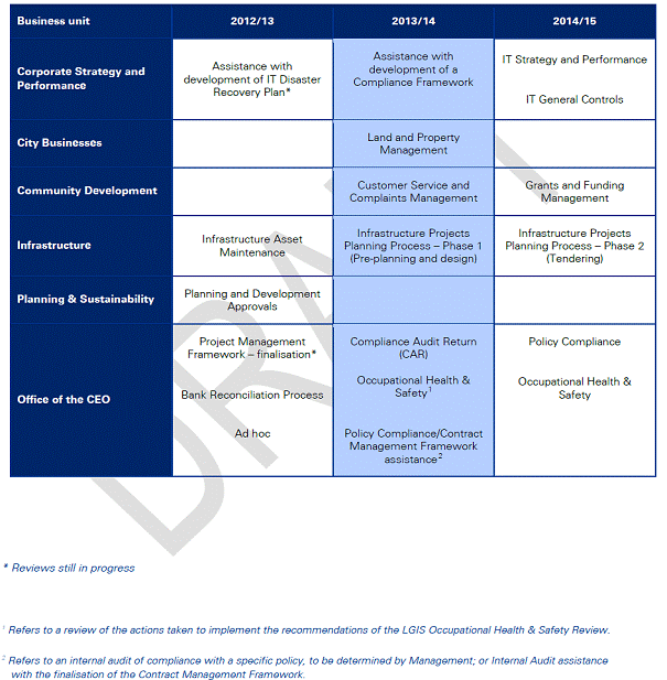
Consultation
The amendments were made based on discussions held between KPMG and the Chief Executive Officer in consultation with relevant Executives and Management.
The Revised Internal Audit Plan for 2013/14 was presented to the Audit Committee of 3 September 2013 (Item 4.3). The Audit Committee resolved to "RECOMMENDS to Council the adoption of the revised Internal Audit Plan for 2013/14, as detailed in Attachment 1."
Comment
The proposed changes to the Internal Audit Plan 2013/14 make provision for both the conduct of internal audits and the development of Frameworks to assist the organisation with strengthening of internal controls.
Statutory Compliance
The planned audits of the Compliance Audit Return (CAR) and the City's Occupational Health and Safety Systems will assist the City in ensuring statutory compliance requirements are met.
Strategic Implications
The proposal aligns with the following objective within the Strategic Community Plan 2013 – 2023:
“4 Civic Leadership - Working with others to ensure the best use of our resources.
4.3 A Strong and Progressive Organisation - You will recognise the hard work and professionalism delivered by your council through your interactions and how our community is developing.”
Policy Implications
The proposed Internal Audit Plan 2013/14 includes provision for new Policy development.
Financial Implications
The cost of implementing the 2013/14 Strategic Internal Audit Plan will be met through the City's Operating budget.
Voting Requirements
Simple Majority
That Council ADOPTS the revised Internal Audit Plan for 2013/14 as detailed in Attachment 1.
Attachments:
|
1View. |
Internal Audit Plan 2013/14 |
13/137138 |
Minuted |
CITY OF WANNEROO Agenda OF Elected Members' Briefing Session 10 September, 2013 380
Governance
File Ref: 2855V02 – 13/145774
Responsible Officer: Director, Corporate Strategy and Performance
Disclosure of Interest: Nil
Attachments: 2
Issue
To consider requests for sponsorships, donations and waiver of fees in accordance with the City’s Donations, Sponsorships and Waiver of Fees and Charges Policy.
Background
The Donations, Sponsorships and Waiver of Fees and Charges Policy requires applications over $500 from individuals and organisations to be determined by Council. Consequently a report is prepared for Council meetings, coinciding with a period where applications of this nature have been received.
With respect to requests for sponsorships, the City’s Policy specifies that for National Events the amount provided will be $200.00 per individual, capped at $600.00 per team, and for International Events the amount provided is $500.00 per individual capped at $1,500.00 per team. Schools are capped at $2,000.00 per school per financial year.
Detail
During this period, the City has received one sponsorship request, two community donation requests and one request for a waiver of fees and charges, which are summarised as follows. Copies of the full applications are available from Governance upon request.
Comment
Sponsorship Donations
|
Applicant 1 – Cycling WA |
|
|
Name of Individual/s |
Jarrod Karel, Matthew Jackson and Niken Jefferies |
|
Reside in City of Wanneroo 18years of age or under |
Yes Yes |
|
Event Details |
Cycling Australia Road National Championships, Wagga Wagga NSW 6 – 8 September 2013 |
|
Commitment to providing a written report regarding the event |
Yes |
|
Commitment to acknowledgement of the City of Wanneroo |
Yes |
|
Eligibility Level |
National ($200 each) |
|
Comments
|
As per the policy $200.00 per individual, capped at $600.00 per team to a maximum of four teams. |
|
Recommendation
|
APPROVE a request for sponsorship in the sum of $600.00 to Cycling WA for the participation of Jarrod Karel, Matthew Jackson and Niken Jefferies to attend the Cycling Australia Road National Championships to be held in Wagga Wagga NSW from 6 – 8 September 2013. |
|
|
This request satisfies the criteria of the policy. |
Community Group Donations
|
Applicant 1 – Gujarati Samaj of WA |
|
|
Request amount |
50% waiver of fees $2,441.40 |
|
Description of request |
"Navratri" Cultural Dance Festival, Kingsway Indoor Stadium, Madeley 4 and 11 October 2013 (see Attachment 1) |
|
Criteria |
Evaluation |
|
Potential for income generation |
A $10 entry fee is being charged. Organisers state this is purely to cover costs. |
|
Status of applicant organisation |
Not for profit |
|
Exclusivity of the event or project |
Open to general members of the public |
Alignment with Council’s existing philosophies, values and strategic direction |
This request supports Objective 2.2 of Council’s Strategic Community Plan being “Healthy and Active People". |
|
Alternative funding sources available or accessed by the organisation |
$1500 (approx) from sale of tickets |
|
Contribution to the event or activity made by the applicant or organisation |
$800.00 plus in-kind 500-600 hrs volunteer time |
|
Previous funding assistance provided to the organisation by the City |
Nil |
|
Commitment to acknowledge the City of Wanneroo |
Yes |
|
Comments |
The Donations, Sponsorships and Waiver of Fees and Charges Policy states Council will not consider funding applications for donations, sponsorships or the waiver of fees and charges for: Item 2.7 "requests that have the potential for income generation or profit or where an entry fee is being charged". Although a fee is being charged, organisers are using this to stage the event, not to make a profit. Elected Members may wish to consider this when making a decision. This group would have applied through the current Community Funding round but this was too late to cover an event in October. They will seek funding for the following year through that avenue. |
|
Recommendation |
NOT APPROVE a 50% Waiver of Fees in the sum of $2,441.40 to the Gujarati Samaj of WA for hire of the Kingsway Indoor Stadium for a "Navratri" Cultural Dance Festival to be held on 4 and 11 October 2013. |
|
Reason |
The request is not in accordance with Council’s Policy. |
|
Applicant 2 – Grandparents Rearing Grandchildren Inc. |
|
|
Request amount |
$1,200.00 |
|
Description of request |
To cover facilitator's fee (Virginia Huupponen, Certified Life Coach) in a life skills workshop for grandparents "Buttons to Boundaries" to be held at the Marangaroo Family Centre on 24 September and half day follow up on 15 October 2013. |
|
Criteria |
Evaluation |
|
Potential for income generation |
Nil |
|
Status of applicant organisation |
Not for profit |
|
Exclusivity of the event or project |
Open to all grandparents |
Alignment with Council’s existing philosophies, values and strategic direction |
This request supports Objective 2.2 of Council’s Strategic Community Plan being “Healthy and Active People". |
|
Alternative funding sources available or accessed by the organisation |
$250 (donation from Marangaroo Family Centre) |
|
Contribution to the event or activity made by the applicant or organisation |
$250 plus $150 volunteer time |
|
Previous funding assistance provided to the organisation by the City |
Nil |
|
Commitment to acknowledge the City of Wanneroo |
Yes |
|
Comments |
The course aims to assist grandparents to build better relationships with friends and family members, avoid stress and create personal boundaries. It is considered that this Workshop will provide substantial benefit to the City of Wanneroo community. |
|
Recommendation |
APPROVE a request for a donation in the sum of $1,200.00 to Grandparents Rearing Grandchildren Inc. to cover facilitator's fee (Virginia Huupponen, Certified Life Coach) in a life skills workshop for grandparents "Buttons to Boundaries" to be held at the Marangaroo Family Centre on 24 September and half day follow up on 15 October 2013. |
|
Reason |
This request satisfies the criteria of the policy. |
|
Applicant 3 – St Anthony's Catholic Church (Klickety Klacks) |
|
|
Request amount |
$4,500.00 |
|
Description of request |
Winter 2014 Appeal – Donation of wool to Klickety Klacks social craft group to knit and crochet 2014 items of clothing, accessories and blankets for the needy, |
|
Criteria |
Evaluation |
|
Potential for income generation |
Nil |
|
Status of applicant organisation |
Not for profit – social group |
|
Exclusivity of the event or project |
Open to anyone in community |
Alignment with Council’s existing philosophies, values and strategic direction |
This request supports Objective 2.2 of Council’s Strategic Community Plan being “Healthy and Active People". |
|
Alternative funding sources available or accessed by the organisation |
Nil |
|
Contribution to the event or activity made by the applicant or organisation |
500 Knee/baby rugs. Each takes approximately 3 balls of yarn x $3 = $4,500 plus 9,000 hours volunteer time. |
|
Previous funding assistance provided to the organisation by the City |
Nil |
|
Commitment to acknowledge the City of Wanneroo |
Yes |
|
Comments |
The organisers of the project have indicated they will need approximately 3,000 balls of wool at $3 per 100g ball. They intend to make 500 Hats, 500 Scarves and 500 Baby garments. Each takes approximately one ball of yarn x $3 = $4,500. The rugs, which also total $4,500 for wool, will be made at the expense of the community group members many of whom are pensioners. All clothes and blankets are donated to those in need (see Attachment 2 – letter from St Anthony's Church).
Klickety Klacks is a social craft group that meets at the Wanneroo Library and currently has 36 members, 27 of whom reside within the City of Wanneroo. They currently donate any items of clothing made at their own cost, to groups such as Emergency Foster Care; Women's Refuge Merriwa; Pregnancy Assistance; Anglicare Drop-in Centres; Miracle Babies; Nursing Homes and Lady Lawley Cottage. They would be happy to donate to any charity within the City of Wanneroo, such as the Mayor's Christmas Appeal. The Church has submitted the application on this group's behalf as Klickety Klacks is a social meeting group and do not have a bank account.
Whilst this appears a very worthwhile application, the Policy does not provide guidance for Administration to determine the extent of support. In view of this, in order to ensure equity of funding capacity from the available budget it is recommended to limit the donation to $2,000.00, however Council may wish to increase the requested amount.
|
|
Recommendation |
APPROVES a request for a donation in the sum of $2,000.00 to St Anthony's Catholic Church (Klickety Klacks) to buy wool to support the Winter 2014 Appeal to donate 2014 knitted and crocheted items of clothing, accessories and blankets for the needy. |
|
Reason |
This request satisfies the criteria of the policy. |
Statutory Compliance
Nil
Strategic Implications
The proposal aligns with the following objective within the Strategic Community Plan 2013 – 2023:
“2 Society - Healthy, safe, vibrant and active communities.
2.2 Healthy and Active People - We get active in our local area and we have many opportunities to experience a healthy lifestyle.”
Policy Implications
The City of Wanneroo Donations, Sponsorship and Waiver of Fees and Charges Policy states that sponsorship applications for attendance at National Events will be capped at $600.00 per team and Regional or State capped at $600 per club. International events will be capped at $1,500.00 per team and schools capped at $2,000.00 per school per financial year.
Financial Implications
|
Budget 2013/2014 |
|
$80 000.00 |
|
Amount expended to date (as at 29 August 2013) |
|
$18,035.05 |
|
Balance |
|
$61,964.95 |
|
Total of requests for this round: Donations (in this report):
Total this Round |
$3,800.00 |
$3,800.00 |
|
BALANCE |
|
$58,164.95 |
Voting Requirements
Simple Majority
Recommendation
That Council:-
1. APPROVES a request for sponsorship in the sum of $600.00 to Cycling WA for the participation of Jarrod Karel, Matthew Jackson and Niken Jefferies to attend the Cycling Australia Road National Championships to be held in Wagga Wagga NSW from 6 – 8 September 2013;
2. NOT APPROVE a 50% Waiver of Fees in the sum of $2,441.40 to the Gujarati Samaj of WA for hire of the Kingsway Indoor Stadium for a "Navratri" Cultural Dance Festival to be held on 4 and 11 October 2013;
3. APPROVES a request for a donation in the sum of $1,200.00 to Grandparents Rearing Grandchildren Inc. to cover facilitator's fee (Virginia Huupponen, Certified Life Coach) in a life skills workshop for grandparents "Buttons to Boundaries" to be held at the Marangaroo Family Centre on 24 September and half day follow up on 15 October 2013; and
4. APPROVES a request for a donation in the sum of $2,000.00 to St Anthony's Catholic Church (Klickety Klacks) to buy wool to support the Winter 2014 Appeal to donate 2014 knitted and crocheted items of clothing, accessories and blankets for the needy.
Attachments:
|
1View. |
Annexure 1 Gujarati Samaj of WA |
13/146969 |
|
|
2View. |
Letter from St Anthony's Church |
13/147105 |
|
Annexure-I
The aim of the organisation is to cultivate an understanding and an appreciation of Gujarati culture, language and society amongst all Australians.
During the year, GSWA organises several events to promote welfare, social, cultural and educational interests of all Gujaratis of WA. Navratri is GSWA's flagship event planned to cater socio-cultural requirement of all age group in the community. This event is open for members of public.
Navratri is celebrated in state of Gujarat over nine days. "Nav" means Nine and "ratri" means nights. Basically it is festival for saluting the power of women in our society.
The festival is basically Gujarati folk danace ( circle dance) along with live band. All ages of people (mainly ladies) dance in tarditional colourful costumes and jewellary. The purpose of this event is to keep alive this traditional festive spirit in the community and at the same time share the cultural values to wider australian community.
This is our flag ship event and we were celebrating it at herb Greham recreation centre since last 8-10 years. Due to the polarisation of Indian community in City of Wanneroo we have organised this event in Kingsway Indoor Stadium. Also we are intending to arrange this event at same place in future.
Please see some of the photographs from last year’s event. Also you can watch video through link http://www.youtube.com/watch?v=fqY0pPuxD9c
3.30 Amendments to the Adopted Council Meeting Schedule
File Ref: 5153 – 13/146964
Responsible Officer: Director, Corporate Strategy and Performance
Disclosure of Interest: Nil
Attachments: Nil
Issue
To consider proposed changes to the adopted Council meeting schedule inclusive of the Annual General Meeting of Electors (AGM) date.
Background
Section 5.10 of the Local Government Act 1995 relates to the appointment of committee members and Section 5.11 to the tenure of committee membership. Membership of a committee continues until:-
“(d) the next ordinary elections day”.
Section 5.27 of the Local Government Act 1995 requires all local governments to conduct a general meeting of electors of a district at least once every financial year to present the City’s Annual Report for the preceding financial year, including the audited financial statements. The AGM must be held no more than 56 days after the local government accepts its annual report
Detail
The impact of the October local government elections together with the availability of the audited financial statements requires that the Council meeting schedule be amended to accommodate the calling of a Special Council Meeting to elect representatives to committees and to elect the Deputy Mayor. This will facilitate the ability of the Audit Committee to meet to consider the audited financials prior to being presented, along with the Annual Report, to Council for consideration on 10 December 2013.
Should Council adopt the Annual Report and audited financials at its meeting of 10 December 2013, the AGM could then be scheduled for 28 January 2014 prior to the first Briefing Session of the New Year.
The following schedule is therefore presented for consideration:-
|
|
|
Date |
|
1. |
Election Day |
Saturday 19 October 2013 |
|
2. |
Swearing-In Ceremony (Proposed that this date be advertised). |
Monday 21 October 2013 6.30pm |
|
3. |
First Induction Session. Part of this session will be dedicated to providing new Councillors with information on the City’s Committees and Working Groups and nomination process as well as process for appointing a Deputy Mayor. (Full program to be advised). |
Tuesday 22 October 2013 7.00pm
|
|
4. |
Second Induction Session (Program to be advised) |
Monday 28 October 2013 6.30pm |
|
5. |
Special Council Meeting to determine Committee and Working Group Representation and to appoint a Deputy Mayor, followed by a third induction session for new Councillors. (Program to be advised) This meeting date requires public advertising. |
Tuesday 29 October 2013 6.00pm |
|
5. |
Fourth Induction Session (Program to be advised |
Monday 04 November 2013 |
|
6. |
Joint Induction Session (Cities of Wanneroo, Stirling and Joondalup) to be held at the City of Stirling. Program to be advised). |
Saturday 9 November
2013 |
|
7. |
Council Briefing and Council Meeting (as per previously adopted meeting schedule). |
05 November 2013
12 November 2013 |
|
8. |
Scheduled Audit and Forum meeting Dates The consideration of the Audited Financials to be considered at the 26 November 2013 Audit Committee in order to be adopted at the December Council meeting. |
14 November 2013 |
|
9. |
Proposed that the AGM be held prior to the first Briefing Session in the new year.
Both the AGM date and the new Briefing session time to be incorporated into the meeting schedule for 2014 still to be considered by Council. |
28 January 2014 Briefing Session – 7.00pm |
Consultation
Nil
Comment
The change to the meeting schedule will facilitate the appointment of representatives to committees, the election of the deputy mayor and accommodate the required induction sessions
Statutory Compliance
Local Government Act 1995, Part 5 – Administration:
Division 2 – Council meetings, committees and their meetings and electors’ meetings; and Division 5 – Annual reports and planning.
Strategic Implications
The proposal accords with the following Outcome Objective of the City’s Strategic Plan 2006 – 2021:
“4 Civic Leadership - Working with others to ensure the best use of our resources.
4.1 Listening and Leading - Our community actively participates in forums and events to discuss and inform the local decision-making.”
Policy Implications
Nil
Financial Implications
Nil
Voting Requirements
Simple Majority
That Council RESOLVE to:-
1. HOLD a Special Council Meeting on 29 October 2013 at 6.00pm for the purpose of appointing the Deputy Mayor and appointing representatives to Committees and Working Groups; and
2. AMEND the City of Wanneroo adopted meeting schedule to change the date of the Annual General Meeting of Electors from 3 December 2013 to 28 January 2014 at 6.00pm.
File Ref: 5642V02 – 13/145690
Responsible Officer: Chief Executive Officer
Disclosure of Interest: Nil
Attachments: 1
Issue
To update Council on the progress of the Deed of Agreement between Yanchep Beach Joint Venture (YBJV) and the City of Wanneroo (City) for delivery of the Yanchep Active Open Space Project (YAOSP).
Background
At the Ordinary Council Meeting on 28 May 2013, Council considered Report CS04-05/13 Yanchep Active Open Space – Deed of Agreement and resolved as follows :
"1. In respect of Condition 1, Council:
a) REAFFIRMS that in accordance with Council's resolution 5 from 10 April 2013, the results of the public consultation on the Charnwood Park proposal will only be considered by Council following gazettal of Amendment No. 122 to District Planning Scheme No. 2. At that stage, it will be known whether the land component for the YAOS is included in the DCP and, if it is, then the YAOS project will proceed (subject to acceptance of the Deed) and there will be no need to continue advancing the Charnwood Park proposal. In the interim, no further action will be taken in respect to the Charnwood Park Proposal; and
b) AGREES to defer investigating alternative active open space sites in Yanchep-Two Rocks, pending the conclusion of negotiations with YBJV on the draft Deed of Agreement.
2. In respect of Condition 2, ADVISES YBJV that the Department of Sport and Recreation has acknowledged that the grant funding for the Yanchep Active Open Space project is still current and available, and is awaiting further advice from the City when the position on the project is finalised;
3. In respect of Condition 3, ADVISES YBJV that:
a) It is considered premature, prejudicial and contrary to orderly and proper planning for Council to provide any form of "guarantee" to YBJV, along the lines it has requested;
b) Council will consider the scope, timing and inclusion of all facilities incorporated in the Draft Yanchep-Two Rocks Developer Contribution Plan under Amendment No. 122 to District Planning Scheme No. 2, including the proposed Yanchep Active Open Space facility, when it considers that Amendment for final adoption scheduled for 25 June 2013, in light of submissions received; and
c) Final determination of Amendment No. 122 to District Planning Scheme No. 2 will rest with the Minister for Planning, not the City of Wanneroo.
4. In respect of Condition 4, ADVISES YBJV that:
a) The draft Deed dated 8 May 2012 is the recognised version received prior to 16 October 2012 as suitable to be used as the basis for further negotiations, subject to review by the City's appointed legal advisers; and
b) Council AGREES to its previously adopted deed principles (from its meetings on 13 December 2011 – Item CR01-12/11, 26 June 2012 – Item CR03-06/12 and 16 October 2012 – Item CR02-10/12) forming the basis for further negotiations with YBJV to finalise a draft Deed of Agreement.
5. In respect of Condition 5, ADVISES YBJV that it is premature for Council to consider releasing the findings of an audit to YBJV, or any other party, given that Council has not yet set the terms of reference for the audit referred to in its decision of 10 April 2013, or appointed an auditor to conduct the audit, nor has Council determined how or when it will consider the findings of that audit;
6. REAFFIRMS its commitment to recommence negotiations with YBJV and ADVISES YBJV that the Chief Executive Officer (assisted by the City's legal advisors as required) is authorised by Council to negotiate on its behalf the terms of the draft Deed of Agreement in conjunction with YBJV’s Chief Executive Officer (and legal advisors as required); and
7. AGREE that the three month period to negotiate and finalise the Deed of Agreement will commence from the date of agreement to recommence negotiations between the City and YBJV".
Pursuant to the 18 May 2013 Resolution 7, the three month period commenced on 21 June 2013, being the date YBJV confirmed its Board's decision to resume negotiations, expires on 21 September 2013.
On 26 June 2013, the City provided written instructions, supported by documentary evidence, to Squire Sanders comprising of a chronology of events from the initial consideration of Lot 9025 in early 2010 to notification from YBJV on 21 June 2013 of its preparedness to recommence negotiations with the City in respect to concluding a Deed of Agreement relating to the YAOSP. The chronology instructions were provided in order that Squire Sanders understand the developments as they occurred for the purposes of drafting the deed principles set down by Council and the further matters agreed between the parties.
Pursuant to the 18 May 2013 Resolution 6, on 10 July, 16 July, 25 July and 1 August 2013, the CEO and the Chief Executive Officer of YBJV (Mr Ang) met to negotiate the terms to be included in a draft Deed of Agreement. As a consequence of those meetings and subsequent consideration thereof by relevant Administration staff, on 7 August 2013 the City provided the draft concluded negotiated position of both the City and YBJV (agreed principles) to Squire Sanders in addition to the draft Deed of Agreement of 8 May 2012, pursuant to the 18 May 2013 Resolution 4(a). A copy of the spreadsheet containing the agreed principles is Attachment 1.
On 8 August 2013, Squire Sanders provided the City with a draft Deed of Agreement for review in respect to the agreed principles contained in Attachment 1 and consideration of any ancillary matters which required inclusion or amendment in the draft Deed of Agreement.
Between 13 and 16 August 2013, Administration compared the draft Deed of Agreement with the agreed principles of Council, the 8 May 2012 draft Deed of Agreement and the matters contained in Attachment 1 to ensure compliance and raised some issues with Squire Sanders in respect thereto. As a consequence of the issues raised, a further draft Deed of Agreement was provided to the City on 19 August 2013 for further review by Administration.
On 22 August 2013, the draft Deed of Agreement was provided to YBJV's nominated legal representative, Ashurst Australia for review by YBJV.
On 3 September 2013, Ashurst Australia advised Squire Sanders that it is reviewing the draft Deed of Agreement for the purposes of convening a meeting with YBJV. At this point in time, the City is unable to estimate how long YBJV will take to further instruct Ashurst Australia and whether or not those instructions will include further matters to be negotiated between the parties.
Detail
On the basis of the discussions with YBJV, YBJV confirmed that it would construct earthworks for two ovals therefore the requirement for consideration of one versus two ovals is no longer applicable to the negotiations between the parties.
The negotiations between the City and YBJV progressed well and both parties undertook that process in good faith.
The essential terms of the draft Deed of Agreement (including the principles adopted by Council) and matters YBJV required to be included, the subject of the discussions during negotiations were in respect of :
1. Gazettal of Amendment No 122 as a condition precedent to the operation of the Deed of Agreement.
2. If Amendment 122 is not gazetted within 12 months, then the Deed of Agreement will terminate.
3. If the Deed of Agreement terminates because Amendment 122 is not gazetted within 12 months, the City will reimburse YBJV the reasonable design costs subject to the Agreed Structure Plan 68 (ASP68) not being amended in respect to the YAOS site, the YAOS site always being available for development of the ovals and the contours and the land surrounding the YAOS site not changing from the contours and levels applicable at the date of adoption of ASP68.
4. Ground works for two ovals related to cost sharing of Marmion Avenue extension to second entry point
5. Treatment of cost of groundworks by YBJV
6. Acquisition by the City of the YAOS Site and mechanism for payment to the YBJV for the YAOS Site.
7. Tender issues
8. Dealing with Grants for groundworks/infrastructure costs by the City
Consultation
Consultation between the City and YBJV has taken place on 6 July, 10 July, 16 July, 25 July and 1 August 2013.
The Squire Sanders draft Deed of Agreement was provided to Ashurst Australia, as and by way of further consultation, on 22 August 2013.
Comment
The negotiations and further consideration of issues raised by each of the parties at the meetings undertaken have progressed in a positive and productive way and concluded with the drafting of a Deed of Agreement by the City's appointed legal panel representative, Squire Sanders. That draft is being considered by YBJV and Ashurst Australia and it is anticipated that some minor issues may be raised by YBJV for further consideration by the City.
Given the complexity of matters agreed between the parties and those which may require further negotiation, the City is of the view that tabling a draft Deed of Agreement within the three month timetable set by Council at the meeting on 28 May 2013 may put unreasonable pressure on YBJV to form a view on the draft Deed of Agreement provided to Ashurst Australia on 22 August 2013, any additional matters it wishes to raise with the City or in respect to the outstanding matters agreed between the parties to be further considered.
In consideration of the above, it is the City's view that the time for negotiating, finalising and tabling a draft Deed of Agreement for Council's consideration should be extended for a further two months so as to ensure that YBJV is not unreasonably required to form a final view on the currently outstanding matters for its consideration and in order that all essential matters are contained within the draft Deed of Agreement. In the event that the draft Deed of Agreement is agreed between the parties and finalised prior to this time, the Deed will be presented to Council at the next, first opportunity.
Statutory Compliance
The comments contained in this report and the actions arising from Council's consideration of this report are subject to the provisions of the Local Government Act 1995, the Local Government Financial Management (Audit) Regulations and the Planning and Development Act 2005.Do not delete this line
Strategic Implications
The proposal aligns with the following objective within the Strategic Community Plan 2013 – 2023:
“3 Economic
3.3 Provision of timely and coordinated regional infrastructure”
Policy Implications
Nil
Financial Implications
There are no direct financial costs associated with Council's consideration of this report. Squire Sanders has been retained through the City's Legal Panel to negotiate the terms of the draft Deed of Agreement and a provisional sum has been included in the 2013/2014 Annual Budget for the associated legal fees. Further, all costs associated with the YAOS are linked to the DCP.
Voting Requirements
Simple Majority
|
Recommendation That Council:- 1. NOTES the positive progress between the City and Yanchep Beach Joint Venture in respect to negotiating the terms to be included in a draft Deed of Agreement; and 2. AGREES that the time consideration included in Council Recommendation 7 adopted at the Ordinary Council meeting held on 38 May 2013 (CS04-05/13) be extended allow a further two months for negotiation, finalisation and presentation to Council of a draft Deed of Agreement between the City and YBJV.
|
CITY OF WANNEROO Agenda OF Elected Members' Briefing Session 10 September, 2013 405
Item 4 Motions on Notice
4.1 Cr Laura Gray – Signalisation of the Marmion Avenue/Peony Boulevard/Lagoon Drive Intersection at Yanchep and Installation of School Zone Signage and Associated 40kmh speed Limit in the same vicinity
Item 5 To Be Tabled at the Briefing
File Ref: 2413 – 13/144590
Responsible Officer: Manager Human Resources
This report is to be dealt with in confidential session, under the terms of the Local Government Act 1995 Section 5.23(2), as follows:
(a) a matter affecting an employee or employees
To be circulated under separate cover.
The next Ordinary Council Meeting has been scheduled for 7:00pm on 17 September 2013, to be held at Council Chambers, Dundebar Road, Wanneroo.