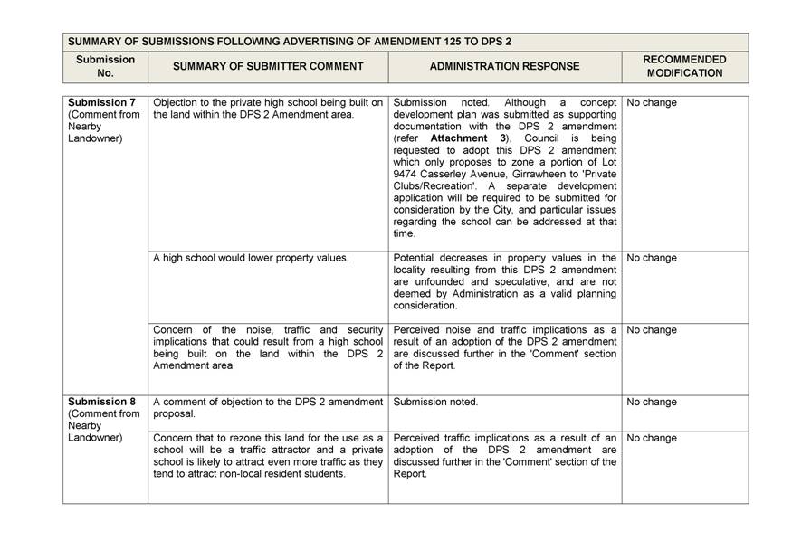
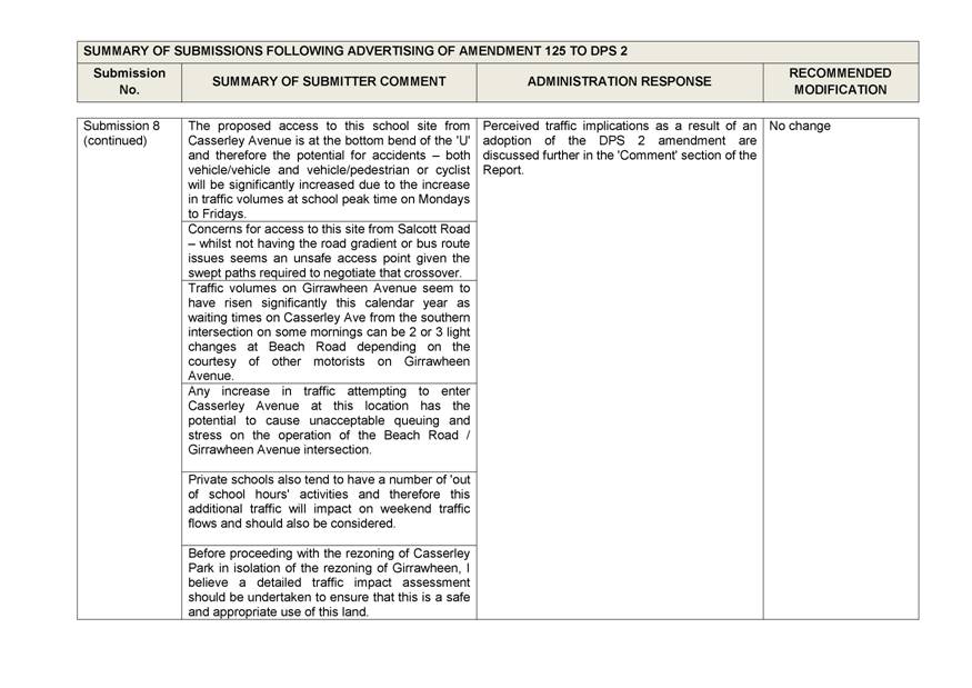
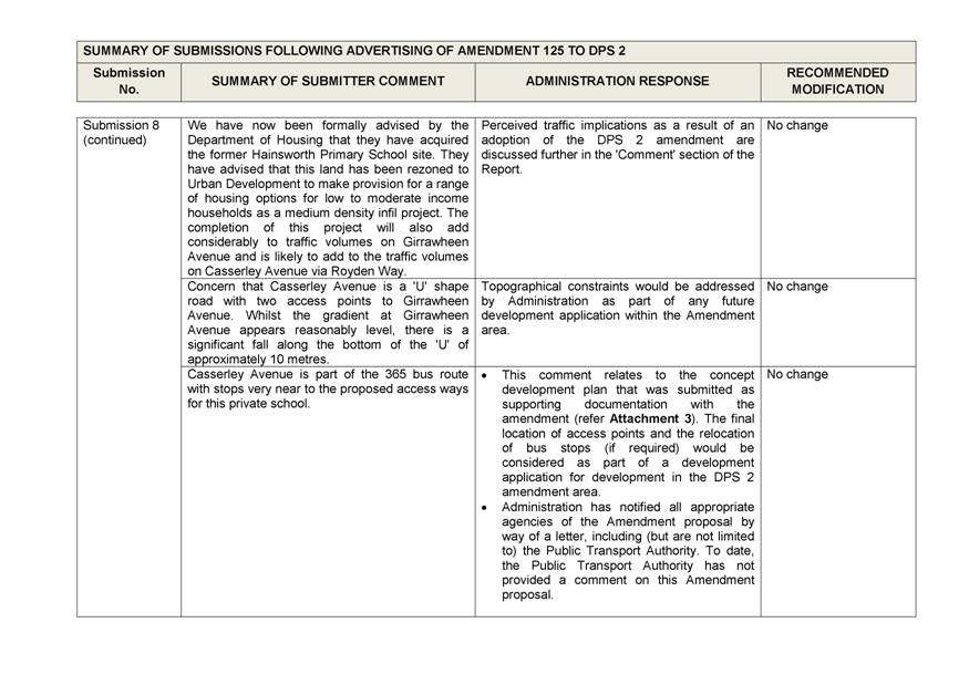
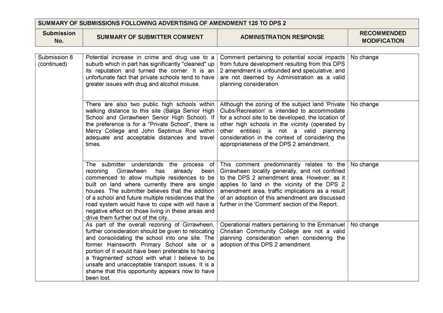
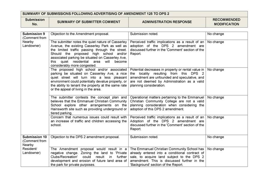
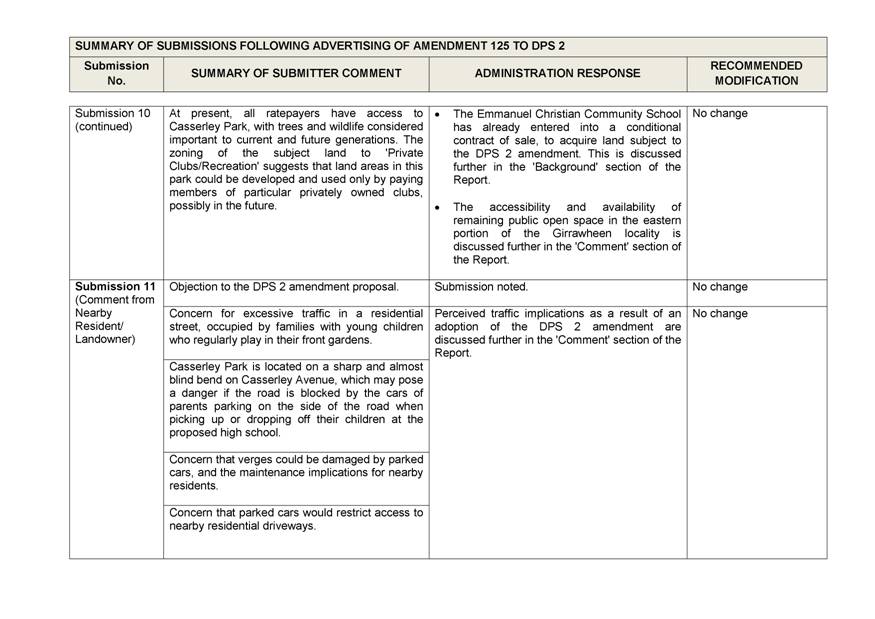
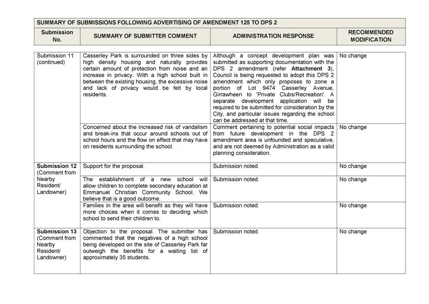
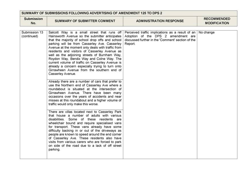
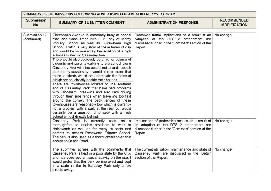
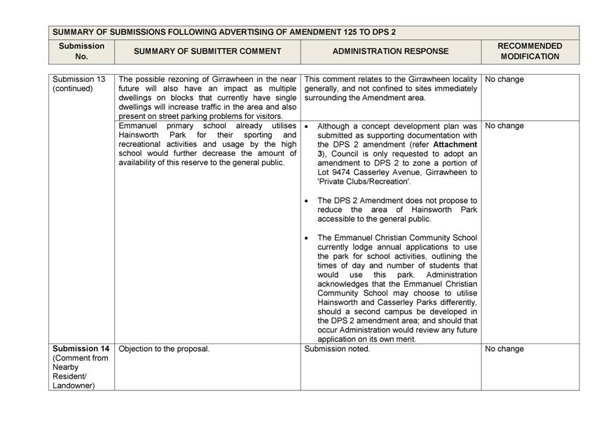
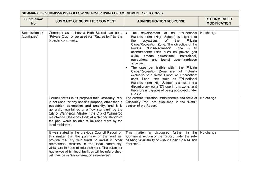
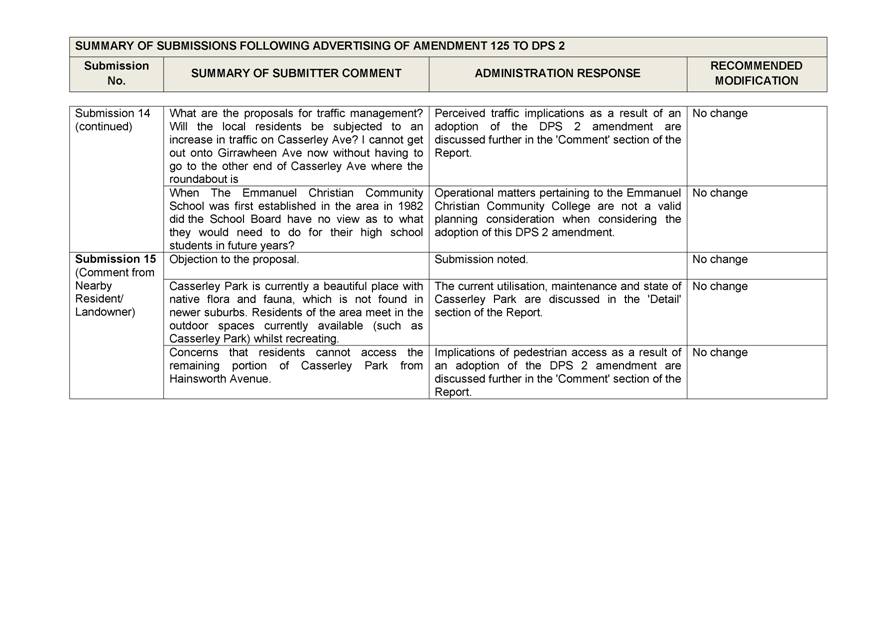
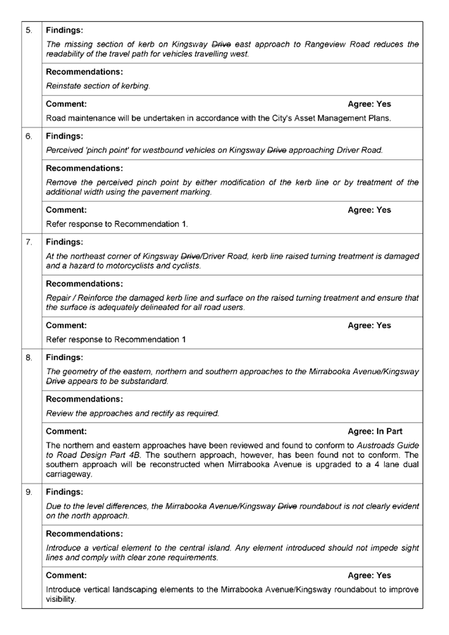
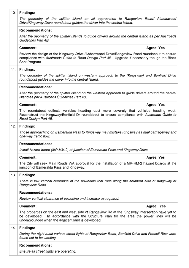
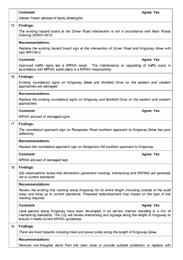
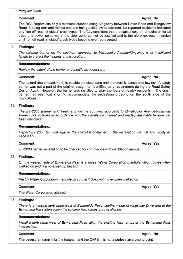
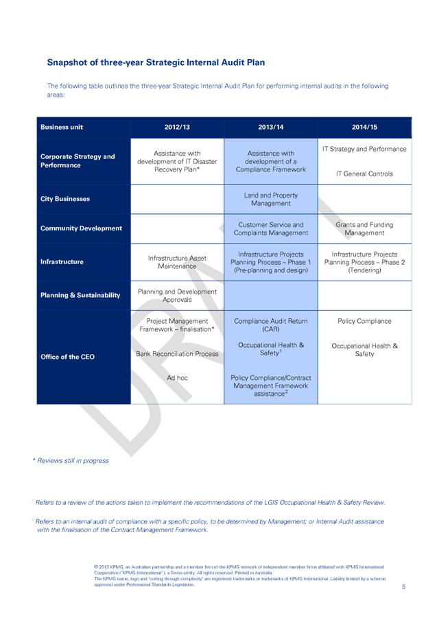
|
WARRANT OF
PAYMENTS JULY 2013
|
|
|
|
|
|
|
PAYMENT
|
DATE
|
DESCRIPTION
|
AMOUNT
|
|
00093382
|
06/08/2013
|
Kylie De Vos
|
$360.00
|
|
|
|
Vehicle Crossing
Subsidy
|
|
|
00093383
|
06/08/2013
|
Bogdanis Nominees Pty Ltd
|
$200.00
|
|
|
|
Refund
Section 40 (80.2013.24.1) - Lot 211 (2) Quinns Road Mindarie - Application
Not Required
|
|
|
00093384
|
06/08/2013
|
Redink Homes
|
$216.00
|
|
|
|
Reimbursement
Of Development Application - Withdrawn As Duplicate
|
|
|
00093385
|
06/08/2013
|
Christian Schools Australia
|
$500.00
|
|
|
|
Bond
Refund - Arts Trailer
|
|
|
00093386
|
06/08/2013
|
Wanneroo BMX Club
|
$1,500.00
|
|
|
|
Sponsorship
For 3 x Children In Their Participation At The ECI BMX World Championships
Auckland 24 - 28.07.2013
|
|
|
00093387
|
06/08/2013
|
Woodvale Secondary College Soccer Excellence Program
|
$1,500.00
|
|
|
|
Sponsorship
For 3 x Children - Secondary Schools Football Challenge Kuala Lumpur
October 2013
|
|
|
00093388
|
06/08/2013
|
Kingsway Little Athletics Centre
|
$1,000.00
|
|
|
|
Sponsorship
- 2 x Children – 21st International Little Athletics
Championships Kuala Lumpur 6 - 7.07.13
|
|
|
00093389
|
06/08/2013
|
Quinns Rocks Volunteer Bush Fire Brigade
|
$1,200.00
|
|
|
|
Sponsorship
For Cadet Unit A - 4 x Children, Cadet Unit B - 3 x Children - 2013
National Australian Fire Cadet Championships Dora Creek NSW 30.09.2013
|
|
|
00093390
|
06/08/2013
|
Butler Bulldogs
|
$600.00
|
|
|
|
Sponsorship
- 3 x Children - Go Kan Ryu Karate Australian World Cup - Sydney
19-21.09.2013
|
|
|
00093391
|
06/08/2013
|
1st Ballajura Scout Group
|
$1,000.00
|
|
|
|
Sponsorship
- 2 x Children - Singapore Scout Camporee 22 - 25.06.2013
|
|
|
00093392
|
06/08/2013
|
Karen Snelling
|
$82.80
|
|
|
|
Refund
- Swim Lessons Term 3 - Cancelled
|
|
|
00093393
|
06/08/2013
|
Marie Short
|
$360.00
|
|
|
|
Vehicle Crossing
Subsidy
|
|
|
00093394
|
06/08/2013
|
Emma Jensen
|
$480.00
|
|
|
|
Bond Refund
|
|
|
00093395
|
06/08/2013
|
Sally Cole
|
$480.00
|
|
|
|
Bond Refund
|
|
|
00093396
|
06/08/2013
|
Elaine Awad
|
$1,600.00
|
|
|
|
Bond Refund
|
|
|
00093397
|
06/08/2013
|
Joondalup United Football Club
|
$750.00
|
|
|
|
Bond Refund
|
|
|
00093398
|
06/08/2013
|
Cause Force
|
$50.00
|
|
|
|
Bond Refund
|
|
|
00093399
|
06/08/2013
|
B Lund
|
$10.00
|
|
|
|
Refund - Gold
Program - Rug Making
|
|
|
00093400
|
06/08/2013
|
J Marinovich
|
$10.00
|
|
|
|
Refund - Gold
Program - Laser Tag
|
|
|
00093401
|
06/08/2013
|
J Ennis
|
$10.00
|
|
|
|
Refund
- Gold Program - Change Of Booking From Laser Corps To Bowling
|
|
|
00093402
|
06/08/2013
|
F Vermeulen & H Simoen
|
$360.00
|
|
|
|
Vehicle Crossing
Subsidy
|
|
|
00093403
|
06/08/2013
|
Khaled Ahmad
|
$360.00
|
|
|
|
Vehicle Crossing
Subsidy
|
|
|
00093404
|
06/08/2013
|
L & M Rossi
|
$360.00
|
|
|
|
Vehicle Crossing
Subsidy
|
|
|
00093405
|
06/08/2013
|
T Weight
|
$18.40
|
|
|
|
Refund
- Swimming Credits Not Re-Enrolling
|
|
|
00093406
|
06/08/2013
|
Cancelled
|
|
|
00093407
|
06/08/2013
|
Affordable Living Homes
|
$561.09
|
|
|
|
Refund
- Development Application - Not Required
|
|
|
00093408
|
06/08/2013
|
Department Of Housing
|
$400.00
|
|
|
|
1 x Financial
Assistance
|
|
|
00093409
|
06/08/2013
|
P McDonald
|
$89.21
|
|
|
|
Refund
- Lost/Damaged Book Charges - Item Returned
|
|
|
00093410
|
06/08/2013
|
Lake Joondalup Baptist College Primary School P &
F
|
$800.00
|
|
|
|
Bond Refund
|
|
|
00093411
|
06/08/2013
|
Nemesis Fight Nights
|
$1,650.00
|
|
|
|
Bond
Refund - Nemesis Fight Show On 15.06.2013
|
|
|
00093412
|
06/08/2013
|
Account Collection Services
|
$363.70
|
|
|
|
1 x Financial
Assistance
|
|
|
00093413
|
06/08/2013
|
A Troy
|
$773.55
|
|
|
|
Refund
Of Gym And Aquatic Membership Fees - Class Cancelled For Cooling Off Period
|
|
|
00093414
|
06/08/2013
|
Longlife Strategies Superannuation
|
$270.00
|
|
|
|
Building
Application Accepted As Uncertified - Should Be Certified 2013/3262
|
|
|
00093415
|
06/08/2013
|
Cancelled
|
|
|
00093416
|
06/08/2013
|
R Castles
|
$18.00
|
|
|
|
Residential
Plan Sales Pool Compliance Certificate
|
|
|
00093417
|
06/08/2013
|
B Huynh
|
$139.00
|
|
|
|
Refund
For Building Application Fee - Codes Variation Fee Not Required
|
|
|
00093418
|
06/08/2013
|
D & T Cotton
|
$360.00
|
|
|
|
Vehicle Crossing
Subsidy
|
|
|
00093419
|
06/08/2013
|
R Buckingham
|
$89.60
|
|
|
|
Refund - Swim
Lessons - Client Cancelled
|
|
|
00093420
|
06/08/2013
|
Baseball WA
|
$500.00
|
|
|
|
Sponsorship
1 x Child Armstrong Participation In The USA Colts Trip 15.06.2012 -
21.07.2012 Reissue Of Cheque #87600 - Incorrect Address
|
|
|
00093421
|
06/08/2013
|
L Godfrey
|
$140.00
|
|
|
|
Refund
- Swim Lessons Term 3 - Client Cancelled
|
|
|
00093422
|
06/08/2013
|
H Workman
|
$92.00
|
|
|
|
Refund
- Swim Lessons Term 3 - Client Cancelled
|
|
|
00093423
|
06/08/2013
|
B Reay
|
$33.60
|
|
|
|
Refund
- Swim Lessons Term 2 - Missed Lessons Due To Health Issue
|
|
|
00093424
|
06/08/2013
|
Alinta Gas
|
$786.55
|
|
|
|
Gas
Supplies For The City
|
|
|
00093425
|
06/08/2013
|
Clarkson Youth Centre Petty Cash
|
$197.85
|
|
|
|
Petty Cash
|
|
|
00093426
|
06/08/2013
|
Landgate
|
$797.50
|
|
|
|
Land Enquiries For
The City
|
|
|
00093427
|
06/08/2013
|
Fines Enforcement Registry
|
$2,193.00
|
|
|
|
Lodgement
Of 51 Infringement Notice Records - Regulatory Services
|
|
|
00093428
|
06/08/2013
|
Quinns Rocks Adult Day Care Petty Cash
|
$90.65
|
|
|
|
Petty Cash
|
|
|
00093429
|
06/08/2013
|
Water Corporation
|
$9,715.16
|
|
|
|
Water Charges For
The City
|
|
|
00093430
|
06/08/2013
|
Cancelled
|
|
|
00093431
|
06/08/2013
|
Cancelled
|
|
|
00093432
|
06/08/2013
|
Synergy
|
$146,143.45
|
|
|
|
Power Supplies For
The City
|
|
|
00093433
|
06/08/2013
|
Telstra
|
$68,279.37
|
|
|
|
Relocation
Of Telstra Assets At Corner Marmion Avenue & Hester Avenue - Projects
|
|
|
00093434
|
06/08/2013
|
Clarkson Library Petty Cash
|
$82.10
|
|
|
|
Petty Cash
|
|
|
00093435
|
06/08/2013
|
Wanneroo Adult Day Centre Petty Cash
|
$93.85
|
|
|
|
Petty Cash
|
|
|
00093436
|
06/08/2013
|
St George Bank Limited
|
$32.50
|
|
|
|
Audit
Confirmation Fees 2013 - Finance
|
|
|
00093437
|
06/08/2013
|
Mr John Di Candilo
|
$62.75
|
|
|
|
Reimbursement
- National Police Certificate
|
|
|
00093438
|
06/08/2013
|
Telstra Store Wanneroo
|
$35.00
|
|
|
|
Flip Case Suits HTC
One - Conservation
|
|
|
00093439
|
06/08/2013
|
City of Gosnells
|
$3,185.20
|
|
|
|
Long
Service Leave Entitlement – J Toomey - Finance
|
|
|
00093440
|
06/08/2013
|
City of Mandurah
|
$579.94
|
|
|
|
Long
Service Leave Entitlement – T Hartland - Finance
|
|
|
00093441
|
13/08/2013
|
Rates Refund
|
$335.27
|
|
00093442
|
13/08/2013
|
Rates Refund
|
$1,967.06
|
|
00093443
|
13/08/2013
|
Robert Holl Master Builder
|
$655.63
|
|
|
|
Reimbursement
Of Development Application - Cancelled
|
|
|
00093444
|
13/08/2013
|
Northern Corridor Developments
|
$380.00
|
|
|
|
Reimbursement
- Detailed Area Plan Application Fees - Agora Village
|
|
|
00093445
|
13/08/2013
|
Cancelled
|
|
|
00093446
|
13/08/2013
|
Rates Refund
|
$2,902.50
|
|
00093447
|
13/08/2013
|
Rates Refund
|
$613.00
|
|
00093448
|
13/08/2013
|
Rates Refund
|
$1,825.48
|
|
00093449
|
13/08/2013
|
M Jurgens
|
$25.00
|
|
|
|
Refund
- School Holiday Programs Laser Corps - Cancelled
|
|
|
00093450
|
13/08/2013
|
Circus Joseph Ashton Pty Ltd
|
$139.00
|
|
|
|
Reimbursement
Of Development Application Fees - Withdrawn
|
|
|
00093451
|
13/08/2013
|
Z Bosch
|
$50.00
|
|
|
|
Refund
- Cancellation Of Hands Up Make Your Own Hand Puppet Workshop
|
|
|
00093452
|
13/08/2013
|
B Blackall
|
$50.00
|
|
|
|
Refund
- Cancellation Of Hands Up Make Your Own Hand Puppet Workshop
|
|
|
00093453
|
13/08/2013
|
M Tomney
|
$360.00
|
|
|
|
Vehicle Crossing
Subsidy
|
|
|
00093454
|
13/08/2013
|
Elaine Wilson
|
$480.00
|
|
|
|
Bond Refund
|
|
|
00093455
|
13/08/2013
|
Paula Walker
|
$750.00
|
|
|
|
Bond Refund
|
|
|
00093456
|
13/08/2013
|
Celia Nascimento
|
$480.00
|
|
|
|
Bond Refund
|
|
|
00093457
|
13/08/2013
|
Suzan Armanious
|
$480.00
|
|
|
|
Bond Refund
|
|
|
00093458
|
13/08/2013
|
Darts of the Southern Hemisphere
|
$750.00
|
|
|
|
Bond Refund
|
|
|
00093459
|
13/08/2013
|
Claire Lark
|
$480.00
|
|
|
|
Bond Refund
|
|
|
00093460
|
13/08/2013
|
Black Swan Taekwondo Inc
|
$480.00
|
|
|
|
Bond Refund
|
|
|
00093461
|
13/08/2013
|
Wanneroo Cricket Club Inc
|
$75.00
|
|
|
|
Key Bond Refund
|
|
|
00093462
|
13/08/2013
|
S & R Lacoul
|
$360.00
|
|
|
|
Vehicle Crossing
Subsidy
|
|
|
00093463
|
13/08/2013
|
Thornlie Christian College
|
$500.00
|
|
|
|
Bond Refund
|
|
|
00093464
|
13/08/2013
|
Wanneroo Bush Fire Brigade
|
$800.00
|
|
|
|
Bond Refund
|
|
|
00093465
|
13/08/2013
|
A Carr
|
$10.00
|
|
|
|
Refund
- Gold Rug Making Client Cancelled
|
|
|
00093466
|
13/08/2013
|
N Nikolskaya
|
$80.00
|
|
|
|
Refund
- Direct Debit Payment For Wanneroo Aquamotion
|
|
|
00093467
|
13/08/2013
|
Vodafone Pty Ltd
|
$130.43
|
|
|
|
1 x Financial
Assistance
|
|
|
00093468
|
13/08/2013
|
The Municipal Workcare Scheme
|
$115.39
|
|
|
|
Refund
- Double Payment Of Debtor 1608-01 Invoice 130811
|
|
|
00093469
|
13/08/2013
|
Greg Rowe & Associates
|
$400.00
|
|
|
|
Reimbursement
Of Detailed Area Application Fee - Withdrawn
|
|
|
00093470
|
13/08/2013
|
Katie Lewis
|
$40.00
|
|
|
|
Dog Registration
Refund - Sterilised
|
|
|
00093471
|
13/08/2013
|
N Prentice
|
$6.00
|
|
|
|
Dog Registration
Refund - Deceased
|
|
|
00093472
|
13/08/2013
|
Jacqueline Kalligeros-Drummond
|
$20.00
|
|
|
|
Dog Registration
Refund - Sterilised
|
|
|
00093473
|
13/08/2013
|
G Cooke
|
$57.00
|
|
|
|
Dog Registration
Refund - Sterilised
|
|
|
00093474
|
13/08/2013
|
K Lord
|
$20.00
|
|
|
|
Dog Registration
Refund - Sterilised
|
|
|
00093475
|
13/08/2013
|
T Anderson
|
$12.00
|
|
|
|
Dog Registration
Refund - Deceased
|
|
|
00093476
|
13/08/2013
|
Tessa Van Vulpen
|
$20.00
|
|
|
|
Dog Registration
Refund - Sterilised
|
|
|
00093477
|
13/08/2013
|
D Parin
|
$40.00
|
|
|
|
Refund For Writing
Your Family History Workshop - 10.08.2013
|
|
|
00093478
|
13/08/2013
|
G P & J M Hondris
|
$357.00
|
|
|
|
Vehicle Crossing
Subsidy
|
|
|
00093479
|
13/08/2013
|
Christian Schools Australia
|
$500.00
|
|
|
|
Bond Refund
|
|
|
00093480
|
13/08/2013
|
Rates Refund
|
$635.68
|
|
00093481
|
13/08/2013
|
Richard Tang
|
$50.00
|
|
|
|
Key Bond Refund
|
|
|
00093482
|
13/08/2013
|
G & N Guerini
|
$360.00
|
|
|
|
Vehicle Crossing
Subsidy
|
|
|
00093483
|
13/08/2013
|
V Basmadjian
|
$360.00
|
|
|
|
Vehicle Crossing
Subsidy
|
|
|
00093484
|
13/08/2013
|
S Deshwal
|
$360.00
|
|
|
|
Vehicle Crossing
Subsidy
|
|
|
00093485
|
13/08/2013
|
S Montes
|
$360.00
|
|
|
|
Vehicle Crossing
Subsidy
|
|
|
00093486
|
13/08/2013
|
D Baum
|
$360.00
|
|
|
|
Vehicle Crossing
Subsidy
|
|
|
00093487
|
13/08/2013
|
D Morrison
|
$360.00
|
|
|
|
Vehicle Crossing
Subsidy
|
|
|
00093488
|
13/08/2013
|
R & C Kerr
|
$360.00
|
|
|
|
Vehicle Crossing
Subsidy
|
|
|
00093489
|
13/08/2013
|
Professionals North Shore
|
$300.00
|
|
|
|
1 x Financial
Assistance
|
|
|
00093490
|
13/08/2013
|
Department of Housing
|
$300.00
|
|
|
|
1 x Financial
Assistance
|
|
|
00093491
|
13/08/2013
|
A Geddes
|
$85.00
|
|
|
|
1 x Financial
Assistance
|
|
|
00093492
|
13/08/2013
|
Professionals Northern Coast
|
$420.00
|
|
|
|
1 x Financial
Assistance
|
|
|
00093493
|
13/08/2013
|
Cancelled
|
|
|
00093494
|
13/08/2013
|
Capricorn Village Joint Venture
|
$159.20
|
|
|
|
Refund Hire Fees
|
|
|
00093495
|
13/08/2013
|
Gymnastics Western Australia
|
$400.00
|
|
|
|
Sponsorship
For 2 x Children - Participation At The Australian Gymnastic Championships
- Sydney 15 - 20.07.2013
|
|
|
00093496
|
13/08/2013
|
Westside BMX Club
|
$500.00
|
|
|
|
Sponsorship
For 1 x Child At The 2013 UCI BMX World Championships In Auckland 15 -
20.07.2013
|
|
|
00093497
|
13/08/2013
|
School Sport WA
|
$200.00
|
|
|
|
Sponsorship
For 1 X Child SSA National AFL Championships At Darwin From 10 - 18.08.2013
|
|
|
00093498
|
13/08/2013
|
School Sport WA
|
$200.00
|
|
|
|
Sponsorship
For 1 x Child At WA Schools Football (Soccer) Team Competition At Richlands
QLD From 14 - 20.09.2013
|
|
|
00093499
|
13/08/2013
|
Alexander Heights Adult Day Care Petty Cash
|
$109.75
|
|
|
|
Petty Cash
|
|
|
00093500
|
13/08/2013
|
Alinta Gas
|
$1,147.70
|
|
|
|
Gas Supplies For
The City
|
|
|
|
|
2 x Financial
Assistance $200.00
|
|
|
00093501
|
13/08/2013
|
AMP Life Limited
|
$3,322.37
|
|
|
|
Payroll Deductions
|
|
|
00093502
|
13/08/2013
|
Construction Training Fund
|
$74,560.78
|
|
|
|
Construction
Levy Payments 01.07 - 31.07.2013 - Finance
|
|
|
00093503
|
13/08/2013
|
Landgate
|
$29,691.16
|
|
|
|
Unimproved
Valuations Chargeable Schedule 01 - 31.07.2013 - Rates
|
|
|
|
|
Mining
Tenements Chargeable Schedule 14.06 - 15.07.2013 - Rates
|
|
|
|
|
Gross
Rental Valuations Chargeable Schedule 20.07 - 02.08.2013 - Rates
|
|
|
00093504
|
13/08/2013
|
Girrawheen Library Petty Cash
|
$206.00
|
|
|
|
Petty Cash
|
|
|
00093505
|
13/08/2013
|
Water Corporation
|
$3,699.63
|
|
|
|
Water Charges For
The City
|
|
|
|
|
1 x Financial
Assistance $200.00
|
|
|
00093506
|
13/08/2013
|
Zurich Client Service
|
$688.41
|
|
|
|
Payroll Deductions
|
|
|
00093507
|
13/08/2013
|
Cancelled
|
|
|
00093508
|
13/08/2013
|
Cancelled
|
|
|
00093509
|
13/08/2013
|
Cancelled
|
|
|
00093510
|
13/08/2013
|
Cancelled
|
|
|
00093511
|
13/08/2013
|
Cancelled
|
|
|
00093512
|
13/08/2013
|
Cancelled
|
|
|
00093513
|
13/08/2013
|
Cancelled
|
|
|
00093514
|
13/08/2013
|
Cancelled
|
|
|
00093515
|
13/08/2013
|
Cancelled
|
|
|
00093516
|
13/08/2013
|
Cancelled
|
|
|
00093517
|
13/08/2013
|
Cancelled
|
|
|
00093518
|
13/08/2013
|
Cancelled
|
|
|
00093519
|
13/08/2013
|
Catholic Superannuation and Retirement Fund
|
$881.67
|
|
|
|
Payroll Deductions
|
|
|
00093520
|
13/08/2013
|
MTAA Superannuation Fund
|
$1,056.38
|
|
|
|
Payroll Deductions
|
|
|
00093521
|
13/08/2013
|
Australiansuper
|
$6,505.19
|
|
|
|
Payroll Deductions
|
|
|
00093522
|
13/08/2013
|
Rest Superannuation
|
$11,842.49
|
|
|
|
Payroll Deductions
|
|
|
00093523
|
13/08/2013
|
Asgard Capital Management Ltd
|
$1,799.87
|
|
|
|
Payroll Deductions
|
|
|
00093524
|
13/08/2013
|
Hospitality Petty Cash
|
$483.05
|
|
|
|
Petty Cash
|
|
|
00093525
|
13/08/2013
|
Unisuper Limited
|
$1,388.76
|
|
|
|
Payroll Deductions
|
|
|
00093526
|
13/08/2013
|
Finance Services Petty Cash
|
$735.75
|
|
|
|
Petty Cash
|
|
|
00093527
|
13/08/2013
|
Hesta Super Fund
|
$3,652.13
|
|
|
|
Payroll Deductions
|
|
|
00093528
|
13/08/2013
|
Prime Super
|
$512.06
|
|
|
|
Payroll Deductions
|
|
|
00093529
|
13/08/2013
|
Colonial First State Firstchoice
|
$3,341.93
|
|
|
|
Payroll Deductions
|
|
|
00093530
|
13/08/2013
|
Care Super
|
$1,235.48
|
|
|
|
Payroll Deductions
|
|
|
00093531
|
13/08/2013
|
Spectrum Super
|
$628.01
|
|
|
|
Payroll Deductions
|
|
|
00093532
|
13/08/2013
|
BT Super For Life
|
$2,591.77
|
|
|
|
Payroll Deductions
|
|
|
00093533
|
13/08/2013
|
Telstra Superannuation Scheme
|
$1,024.68
|
|
|
|
Payroll Deductions
|
|
|
00093534
|
13/08/2013
|
Amist Super
|
$1,149.34
|
|
|
|
Payroll Deductions
|
|
|
00093535
|
13/08/2013
|
Agest Administration
|
$197.78
|
|
|
|
Payroll Deductions
|
|
|
00093536
|
13/08/2013
|
Valdor Superannuation Fund
|
$348.18
|
|
|
|
Payroll Deductions
|
|
|
00093537
|
13/08/2013
|
Vision Super Pty Ltd
|
$591.12
|
|
|
|
Payroll Deductions
|
|
|
00093538
|
13/08/2013
|
Recruitmentsuper
|
$2,184.04
|
|
|
|
Payroll Deductions
|
|
|
00093539
|
13/08/2013
|
Macquarie Investment Management Ltd
|
$178.03
|
|
|
|
Payroll Deductions
|
|
|
00093540
|
13/08/2013
|
Sunsuper Pty Ltd
|
$1,106.15
|
|
|
|
Payroll Deductions
|
|
|
00093541
|
13/08/2013
|
Construction & Building Unions
|
$1,174.59
|
|
|
|
Payroll Deductions
|
|
|
00093542
|
13/08/2013
|
Plum Superannuation Fund
|
$1,720.60
|
|
|
|
Payroll Deductions
|
|
|
00093543
|
13/08/2013
|
ANZ Superannuation Saving Account
|
$154.28
|
|
|
|
Payroll Deductions
|
|
|
00093544
|
13/08/2013
|
Perpetual Wealth Focus Super Plan
|
$603.15
|
|
|
|
Payroll Deductions
|
|
|
00093545
|
13/08/2013
|
Statewide Superannuation Trust
|
$755.82
|
|
|
|
Payroll Deductions
|
|
|
00093546
|
13/08/2013
|
IHS Superannuation Fund
|
$54.21
|
|
|
|
Payroll Deductions
|
|
|
00093547
|
13/08/2013
|
AXA Australia
|
$614.07
|
|
|
|
Payroll Deductions
|
|
|
00093548
|
13/08/2013
|
The Trustee For Oldy's Super Fund
|
$43.78
|
|
|
|
Payroll Deductions
|
|
|
00093549
|
13/08/2013
|
MLC Nominees Pty Ltd (Employer Super)
|
$58.38
|
|
|
|
Payroll Deductions
|
|
|
00093550
|
13/08/2013
|
Bendigo & Adelaide Bank Staff
|
$697.62
|
|
|
|
Payroll Deductions
|
|
|
00093551
|
13/08/2013
|
Victorian Superannuation Fund
|
$584.32
|
|
|
|
Payroll Deductions
|
|
|
00093552
|
13/08/2013
|
Eagles Junior Basketball Club (Inc)
|
$145.00
|
|
|
|
Kidsport Voucher X
1 Child
|
|
|
00093553
|
13/08/2013
|
Commonwealth Bank Group Super
|
$591.12
|
|
|
|
Payroll Deductions
|
|
|
00093554
|
13/08/2013
|
Matrix Superannuation Master Trust
|
$890.16
|
|
|
|
Payroll Deductions
|
|
|
00093555
|
13/08/2013
|
The Trustee for Tindari Self Manage
|
$210.81
|
|
|
|
Payroll Deductions
|
|
|
00093556
|
13/08/2013
|
Mr John Di Candilo
|
$120.00
|
|
|
|
Reimbursement
- Drivers Medical Assessment
|
|
|
00093557
|
13/08/2013
|
Telstra
|
$12,631.26
|
|
|
|
Internet/Phone
Charges For The City
|
|
|
00093558
|
13/08/2013
|
Department of Housing
|
$400.00
|
|
|
|
1 x Financial
Assistance
|
|
|
00093559
|
13/08/2013
|
Navigator Applications Account
|
$304.02
|
|
|
|
Payroll Deductions
|
|
|
00093560
|
13/08/2013
|
Hostplus Superannuation Fund
|
$3,669.23
|
|
|
|
Payroll Deductions
|
|
|
00093561
|
13/08/2013
|
Australian Super
|
$6,540.57
|
|
|
|
Payroll Deductions
|
|
|
00093562
|
13/08/2013
|
MLC Nominees Pty Limited
|
$2,748.00
|
|
|
|
Payroll Deductions
|
|
|
00093563
|
13/08/2013
|
The Industry Superannuation Fund
|
$632.43
|
|
|
|
Payroll Deductions
|
|
|
00093564
|
13/08/2013
|
1OOF Portfolio Service Superannuation
|
$468.93
|
|
|
|
Payroll Deductions
|
|
|
00093565
|
13/08/2013
|
Integra Super
|
$994.16
|
|
|
|
Payroll Deductions
|
|
|
00093566
|
13/08/2013
|
Coles Supermarkets Aust Pty Ltd
|
$500.00
|
|
|
|
Gift
Voucher - V Humphries Retirement Gift
|
|
|
00093567
|
13/08/2013
|
G & S Maintenance
|
$600.00
|
|
|
|
Remove
Asbestos From Casserley Park - Parks
|
|
|
00093568
|
13/08/2013
|
Lexis Nexis
|
$7,419.80
|
|
|
|
Civil
Proc West Australia Issue 147 - Legal Services
|
|
|
|
|
Online
Legal Research Subscription Practical Guidance Module June 2013 - May 2014
- Legal Services
|
|
|
00093569
|
13/08/2013
|
Mirco Bros Pty Ltd Oil Distributors
|
$2,523.90
|
|
|
|
Various Items -
Parks
|
|
|
00093570
|
13/08/2013
|
North Metropolitan Health Services
|
$70.00
|
|
|
|
Registration
Fee - Understanding And Working With Young People Who Self-Harm For T
Reynolds - Youth Programs
|
|
|
00093571
|
13/08/2013
|
State Library of WA
|
$24.20
|
|
|
|
Lost/Damaged
Book Charges
|
|
|
00093572
|
13/08/2013
|
Cancelled
|
|
|
00093573
|
13/08/2013
|
Cancelled
|
|
|
00093574
|
13/08/2013
|
Synergy
|
$52,809.05
|
|
|
|
Power Supplies For
The City
|
|
|
|
|
4 x Financial
Assistance $539.35
|
|
|
00093575
|
15/08/2013
|
Coles Supermarkets Aust Pty Ltd
|
$1,000.00
|
|
|
|
Coles
Myer Gift Voucher For C Higo Retirement Gift - Projects
|
|
|
00093576
|
19/08/2013
|
Cr F Cvitan
|
$3,538.13
|
|
|
|
Councillors
Allowance - Monthly
|
|
|
00093577
|
19/08/2013
|
Cr Dorothy Newton
|
$3,454.80
|
|
|
|
Councillors
Allowance - Monthly - Rates $83.33
|
|
|
00093578
|
20/08/2013
|
Rate Refund
|
$919.20
|
|
00093579
|
20/08/2013
|
Rate Refund
|
$788.52
|
|
00093580
|
20/08/2013
|
Brighton Playgroup
|
$480.00
|
|
|
|
Bond Refund
|
|
|
00093581
|
20/08/2013
|
Reformed Evangelical Church In Aust
|
$480.00
|
|
|
|
Bond Refund
|
|
|
00093582
|
20/08/2013
|
Michelle Du Toit
|
$504.00
|
|
|
|
Bond Refund
|
|
|
00093583
|
20/08/2013
|
Rohina Assadullah
|
$480.00
|
|
|
|
Bond Refund
|
|
|
00093584
|
20/08/2013
|
Libby Hita
|
$480.00
|
|
|
|
Bond Refund
|
|
|
00093585
|
20/08/2013
|
Ridgewood Little Athletics Centre
|
$480.00
|
|
|
|
Bond Refund
|
|
|
00093586
|
20/08/2013
|
Lisa Serraino
|
$480.00
|
|
|
|
Bond Refund
|
|
|
00093587
|
20/08/2013
|
Diana Baker
|
$504.00
|
|
|
|
Bond Refund
|
|
|
00093588
|
20/08/2013
|
Helen Anderson
|
$480.00
|
|
|
|
Bond Refund
|
|
|
00093589
|
20/08/2013
|
Mr Ahmed H Esat
|
$504.00
|
|
|
|
Bond Refund
|
|
|
00093590
|
20/08/2013
|
Jessica Auditore
|
$50.00
|
|
|
|
Bond Refund
|
|
|
00093591
|
20/08/2013
|
Rate Refund
|
$237.95
|
|
00093592
|
20/08/2013
|
Department of Housing
|
$300.00
|
|
|
|
1 x Financial
Assistance
|
|
|
00093593
|
20/08/2013
|
Ventura Homes
|
$1,384.06
|
|
|
|
Refund Codes
Variation Not Required
|
|
|
00093594
|
20/08/2013
|
K Cvitan
|
$12.00
|
|
|
|
Dog Registration
Refund - Deceased
|
|
|
00093595
|
20/08/2013
|
D Ritchie
|
$360.00
|
|
|
|
Vehicle Crossing
Subsidy
|
|
|
00093596
|
20/08/2013
|
T Thomas
|
$265.00
|
|
|
|
Vehicle Crossing
Subsidy
|
|
|
00093597
|
20/08/2013
|
D & J Vicary
|
$360.00
|
|
|
|
Vehicle Crossing
Subsidy
|
|
|
00093598
|
20/08/2013
|
D Deacon & A Cirolli
|
$360.00
|
|
|
|
Vehicle Crossing
Subsidy
|
|
|
00093599
|
20/08/2013
|
J Corp T/As Homestart
|
$506.19
|
|
|
|
Reimbursement
Of Development Application Fees - Duplicated
|
|
|
00093600
|
20/08/2013
|
Signs & Lines
|
$139.00
|
|
|
|
Reimbursement
Of Development Application Fees - Withdrawn
|
|
|
00093601
|
20/08/2013
|
Aussie Living Homes
|
$448.18
|
|
|
|
Reimbursement
Of Development Application Fees - Withdrawn
|
|
|
00093602
|
20/08/2013
|
W Walker
|
$32.00
|
|
|
|
Refund
- Gold Program - Gin Gin Client Cancelled
|
|
|
00093603
|
20/08/2013
|
V Ingleby
|
$6.00
|
|
|
|
Refund
- Gold Program - BBQ And Beach Walk Client Cancelled
|
|
|
00093604
|
20/08/2013
|
J Stapleton
|
$6.00
|
|
|
|
Refund
- Gold Program - BBQ And Beach Walk Client Cancelled
|
|
|
00093605
|
20/08/2013
|
C Weaver
|
$12.00
|
|
|
|
Refund
- Gold Program - Senior Self Defense Client Cancelled
|
|
|
00093606
|
20/08/2013
|
A Carr
|
$6.00
|
|
|
|
Refund
- Gold Program - BBQ And Beach Walk Client Cancelled
|
|
|
00093607
|
20/08/2013
|
K Ondek
|
$438.48
|
|
|
|
Refund
Of Membership Fees Charged At Full Rate Instead Of CoW Discount 14 Payments
- Aquamotion
|
|
|
00093608
|
20/08/2013
|
A Palmer
|
$360.00
|
|
|
|
Vehicle Crossing
Subsidy
|
|
|
00093609
|
20/08/2013
|
P D'Costa
|
$63.84
|
|
|
|
Refund
- Swim Lesson In Term 1 2013 Due To Medical Reasons
|
|
|
00093610
|
20/08/2013
|
Magistrates Court
|
$249.00
|
|
|
|
Notice
Of Intention To Defend General Procedure Claim - 3 Pre-Trial Conference Fee
- Rating Services
|
|
|
00093611
|
20/08/2013
|
Jean-Michel & Kim Landuyt
|
$360.00
|
|
|
|
Vehicle Crossing
Subsidy
|
|
|
00093612
|
20/08/2013
|
T Alexander
|
$360.00
|
|
|
|
Vehicle Crossing
Subsidy
|
|
|
00093613
|
20/08/2013
|
S Lewis
|
$360.00
|
|
|
|
Vehicle Crossing
Subsidy
|
|
|
00093614
|
20/08/2013
|
Rate Refund
|
$517.70
|
|
00093615
|
20/08/2013
|
Rate Refund
|
$2,675.90
|
|
00093616
|
20/08/2013
|
Alinta Gas
|
$479.75
|
|
|
|
1 x Financial
Assistance $400.40
|
|
|
|
|
Gas Supplies For
The City
|
|
|
00093617
|
20/08/2013
|
Facility Officer WLCC Petty Cash
|
$58.05
|
|
|
|
Petty Cash
|
|
|
00093618
|
20/08/2013
|
Mr Evan Martin
|
$257.00
|
|
|
|
Keyholder/Tennis
Court Booking Officer Payment For July 2013
|
|
|
00093619
|
20/08/2013
|
Quinns Rocks Adult Day Care Petty Cash
|
$184.55
|
|
|
|
Petty Cash
|
|
|
00093620
|
20/08/2013
|
Water Corporation
|
$3,300.38
|
|
|
|
Water Supplies For
The City
|
|
|
|
|
2 x Financial
Assistance $400.00
|
|
|
00093621
|
20/08/2013
|
Cancelled
|
|
|
00093622
|
20/08/2013
|
Synergy
|
$10,490.85
|
|
|
|
Power Supplies For
The City
|
|
|
|
|
2 x Financial
Assistance $500.00
|
|
|
00093623
|
20/08/2013
|
Telstra
|
$13,287.34
|
|
|
|
1 x Financial
Assistance $100.00
|
|
|
|
|
Phone Charges For
The City - IT
|
|
|
00093624
|
20/08/2013
|
Mrs Jennifer Martin
|
$226.20
|
|
|
|
Keyholder/Tennis
Court Booking Officer Payment For July 2013
|
|
|
00093625
|
20/08/2013
|
Ms Deanne Hetherington
|
$215.90
|
|
|
|
Keyholder Payment
For July 2013
|
|
|
00093626
|
20/08/2013
|
Zurich Aust Insurance Ltd
|
$1,000.00
|
|
|
|
Motor
Vehicle Insurance Claim Excess Payment - WN 32908
|
|
|
00093627
|
20/08/2013
|
Australia Post
|
$603.80
|
|
|
|
Renewal
Of Mail Redirection Service - Lisford Avenue Phil Renkin Building -
Information Management
|
|
|
00093628
|
20/08/2013
|
Ms Jodie Walter
|
$102.80
|
|
|
|
Keyholder Payment
For July 2013
|
|
|
00093629
|
20/08/2013
|
Ms Venetia Donnellan
|
$174.80
|
|
|
|
Keyholder/Tennis
Court Booking Officer Payment July 2013
|
|
|
00093630
|
20/08/2013
|
Mrs Kim Forrestal
|
$51.40
|
|
|
|
Keyholder Payment
For July 2013
|
|
|
00093631
|
20/08/2013
|
Yanchep Netball Club Incorporated
|
$200.00
|
|
|
|
Kidsport Voucher X
1 Child
|
|
|
00093632
|
20/08/2013
|
Geoffrey Bottomley
|
$192.80
|
|
|
|
Keyholder Payment
For July 2013
|
|
|
00093633
|
20/08/2013
|
R Macri
|
$180.00
|
|
|
|
Refund
- Building Application - Charged For Uncertified - Should Be Certified
|
|
|
00093634
|
25/08/2013
|
Altronic Distributors
|
$19.40
|
|
|
|
Various Items For
Fleet
|
|
|
00093635
|
25/08/2013
|
Bridgeall Libraries Limited
|
$10,000.00
|
|
|
|
Annual
Subscription And Implementation Charges - Library Services
|
|
|
00093636
|
25/08/2013
|
CNW Pty Ltd
|
$54.45
|
|
|
|
Pit Lid -
Engineering
|
|
|
00093637
|
25/08/2013
|
Coles Supermarkets Aust Pty Ltd
|
$1,000.00
|
|
|
|
Gift Voucher -
Retirement Gift - Mal Brown
|
|
|
00093638
|
25/08/2013
|
Cooldrive Distribution
|
$376.61
|
|
|
|
Spare Parts For
Fleet
|
|
|
00093639
|
25/08/2013
|
Cancelled
|
|
|
00093640
|
25/08/2013
|
Developmental Disability Council of
|
$100.00
|
|
|
|
Autism
Anxiety Parental Distress And Mental Health Event - Aquamotion
|
|
|
00093641
|
25/08/2013
|
G & S Maintenance
|
$1,820.00
|
|
|
|
Relay
Paving - Various Locations - Waste
|
|
|
|
|
Remove
Asbestos - Various Locations - Waste
|
|
|
00093642
|
25/08/2013
|
Gloria R Cnapich
|
$130.00
|
|
|
|
Entertainment
For Christmas In July Party - Funded Services
|
|
|
00093643
|
25/08/2013
|
Harvey Norman AV/TI Superstore
|
$1,133.00
|
|
|
|
Replacement
Of Microwave Oven - 3 x Community Centres - Facilities
|
|
|
00093644
|
25/08/2013
|
Makene Holdings Pty Ltd
|
$1,120.00
|
|
|
|
Training
- HR Driving Licence - D Goljok - WRC
|
|
|
00093645
|
25/08/2013
|
Marevic Enterprises Pty Ltd
|
$130.00
|
|
|
|
Supply Of Materials
- Parks
|
|
|
00093646
|
25/08/2013
|
Mirco Bros Pty Ltd Oil Distributors
|
$393.30
|
|
|
|
Various Items -
Parks
|
|
|
00093647
|
25/08/2013
|
Mrs Hebe Morgan
|
$125.00
|
|
|
|
Books For Heritage
& Museums
|
|
|
00093648
|
25/08/2013
|
North Metropolitan Health Services
|
$70.00
|
|
|
|
Training
- Working With Complex Trauma 26.06.2013 - R Clough
|
|
|
00093649
|
25/08/2013
|
Quirks Australia Pty Ltd
|
$493.90
|
|
|
|
Skope
SK1000 Fridge - Emergency Services
|
|
|
00093650
|
25/08/2013
|
RAC Motoring & Services Pty Ltd
|
$511.00
|
|
|
|
Call
Out - 3 x Vehicles - Fleet
|
|
|
|
|
New
Vehicle Nomination Fee WN 33506 - Fleet
|
|
|
00093651
|
25/08/2013
|
Repco Auto Parts & Accessories
|
$154.00
|
|
|
|
Spare Parts For
Fleet
|
|
|
00093652
|
25/08/2013
|
Sensis Pty Ltd
|
$129.80
|
|
|
|
Advertising
- Health And Fitness Centres - Aquamotion
|
|
|
00093653
|
25/08/2013
|
State Library of WA
|
$8,211.40
|
|
|
|
Lost/Damaged
Book Charges - Library Services
|
|
|
|
|
Service
Charge Van Deliveries - Library Services
|
|
|
00093654
|
25/08/2013
|
Stephen McKee
|
$2,000.00
|
|
|
|
Removal
Of Asbestos From Old Yanchep Road - Waste
|
|
|
00093655
|
25/08/2013
|
Suncorp Metway
|
$30.00
|
|
|
|
Audit
Confirmation Fees 2013 - Finance
|
|
|
00093656
|
25/08/2013
|
The Active Network
|
$21,840.00
|
|
|
|
Class
Registration/Maintenance/Support - IT
|
|
|
00093657
|
25/08/2013
|
Wanneroo Automatic Transmission
|
$440.00
|
|
|
|
Repair
Torque Converter - Fleet
|
|
|
00093658
|
25/08/2013
|
Webforge
|
$1,320.02
|
|
|
|
Various
Items For Fleet
|
|
|
00093659
|
25/08/2013
|
West Australian Opera Company
|
$1,200.00
|
|
|
|
Groceries
For Insideart - Heritage
|
|
|
00093660
|
26/08/2013
|
M Latip
|
$20.50
|
|
|
|
Refund
- Direct Debit In Error - Debited As An Adult Fees Instead Of Concession
Debited $70 Instead Of $59.50
|
|
|
00093661
|
26/08/2013
|
Australian Refrigeration Council Ltd
|
$130.00
|
|
|
|
Refrigeration
Handling License - Reference L011191 J Fryer, CoW - Fleet
|
|
|
00093662
|
27/08/2013
|
Rate Refund
|
$108.66
|
|
00093663
|
27/08/2013
|
Patricia Taylor
|
$750.00
|
|
|
|
Bond Refund
|
|
|
00093664
|
27/08/2013
|
Rate Refund
|
$293.99
|
|
00093665
|
27/08/2013
|
Rate Refund
|
$665.15
|
|
00093666
|
27/08/2013
|
Rate Refund
|
$3,177.26
|
|
00093667
|
27/08/2013
|
Rate Refund
|
$689.67
|
|
00093668
|
27/08/2013
|
Rate Refund
|
$218.26
|
|
00093669
|
27/08/2013
|
Rate Refund
|
$33.96
|
|
00093670
|
27/08/2013
|
Rate Refund
|
$110.00
|
|
00093671
|
27/08/2013
|
Rate Refund
|
$1,351.15
|
|
00093672
|
27/08/2013
|
Catherine Araya
|
$787.50
|
|
|
|
Bond Refund
|
|
|
00093673
|
27/08/2013
|
Cancelled
|
|
|
00093674
|
27/08/2013
|
Haydar Pty Ltd
|
$504.00
|
|
|
|
Bond Refund
|
|
|
00093675
|
27/08/2013
|
Nerissa Toh
|
$480.00
|
|
|
|
Bond Refund
|
|
|
00093676
|
27/08/2013
|
Niraj Patel
|
$480.00
|
|
|
|
Bond Refund
|
|
|
00093677
|
27/08/2013
|
Hannia Villarreal
|
$504.00
|
|
|
|
Bond Refund
|
|
|
00093678
|
27/08/2013
|
Fiona Cunningham
|
$480.00
|
|
|
|
Bond Refund
|
|
|
00093679
|
27/08/2013
|
Quinns Districts Amateur Football
|
$750.00
|
|
|
|
Bond Refund
|
|
|
00093680
|
27/08/2013
|
Anitha George
|
$480.00
|
|
|
|
Bond Refund
|
|
|
00093681
|
27/08/2013
|
Amanda Greenwood
|
$504.00
|
|
|
|
Bond Refund
|
|
|
00093682
|
27/08/2013
|
Gabrielle Caravella
|
$504.00
|
|
|
|
Bond Refund
|
|
|
00093683
|
27/08/2013
|
Silky Kanojia
|
$750.00
|
|
|
|
Bond Refund
|
|
|
00093684
|
27/08/2013
|
Amanda Robinson
|
$460.70
|
|
|
|
Bond Refund
|
|
|
00093685
|
27/08/2013
|
Yanchep & Districts Country Womens Assoc
|
$480.00
|
|
|
|
Bond Refund
|
|
|
00093686
|
27/08/2013
|
Colin Blab
|
$360.00
|
|
|
|
Vehicle Crossing
Subsidy
|
|
|
00093687
|
27/08/2013
|
P Lonergan & A Arnold
|
$360.00
|
|
|
|
Vehicle Crossing
Subsidy
|
|
|
00093688
|
27/08/2013
|
Ivan Tan
|
$360.00
|
|
|
|
Vehicle Crossing
Subsidy
|
|
|
00093689
|
27/08/2013
|
Dean Martin
|
$360.00
|
|
|
|
Vehicle Crossing
Subsidy
|
|
|
00093690
|
27/08/2013
|
Diana Crosse
|
$360.00
|
|
|
|
Vehicle Crossing
Subsidy
|
|
|
00093691
|
27/08/2013
|
Terri Paterson Pty Ltd
|
$230.00
|
|
|
|
1 x Financial
Assistance
|
|
|
00093692
|
27/08/2013
|
Monica Kane
|
$113.50
|
|
|
|
Reimbursement
Of Infringement 1007026 Paid Twice Cheque Re-Issued Original Not Received
|
|
|
00093693
|
27/08/2013
|
D Williams & B Ogden
|
$271.00
|
|
|
|
Vehicle Crossing
Subsidy
|
|
|
00093694
|
27/08/2013
|
Buzz Homes And Living
|
$588.68
|
|
|
|
Reimbursement
- Development Application Not Required
|
|
|
00093695
|
27/08/2013
|
Freelife Homes
|
$428.69
|
|
|
|
Reimbursement
- Development Application Not Required
|
|
|
00093696
|
27/08/2013
|
Inspired Homes
|
$1,245.38
|
|
|
|
Reimbursement
- Development Application Not Required
|
|
|
00093697
|
27/08/2013
|
Don Russell Homes Pty Ltd
|
$581.82
|
|
|
|
Reimbursement
- Development Application Not Required
|
|
|
00093698
|
27/08/2013
|
Don Russell Homes Pty Ltd
|
$539.80
|
|
|
|
Reimbursement
- Development Application Not Required
|
|
|
00093699
|
27/08/2013
|
Affordable Living Homes
|
$506.46
|
|
|
|
Reimbursement
- Development Application Not Required
|
|
|
00093700
|
27/08/2013
|
AA Meetings
|
$26.43
|
|
|
|
Refund - Booking
Fee Cancelled
|
|
|
00093701
|
27/08/2013
|
Dorothy Jones
|
$6.00
|
|
|
|
Refund
- Gold Program BBQ & Beach Walk
|
|
|
00093702
|
27/08/2013
|
Jesse Lovelock
|
$2,120.00
|
|
|
|
Refund
- Overpaid HACC Account - Programs
|
|
|
00093703
|
27/08/2013
|
Foundation Housing
|
$245.47
|
|
|
|
1 x Financial
Assistance
|
|
|
00093704
|
27/08/2013
|
Department of Housing
|
$300.00
|
|
|
|
1 x Financial
Assistance
|
|
|
00093705
|
27/08/2013
|
Healy Constructions
|
$147.00
|
|
|
|
Refund
- Development Application Fee
|
|
|
00093706
|
27/08/2013
|
Homegroup WA
|
$791.38
|
|
|
|
Reimbursement
- Development Application Not Required
|
|
|
00093707
|
27/08/2013
|
Studio 8 Builders & Designers
|
$1,479.99
|
|
|
|
Reimbursement
- Development Application Not Required
|
|
|
00093708
|
27/08/2013
|
Capricorn Village Joint Venture
|
$6,461.58
|
|
|
|
Refund
Portion Of Fees Not Expended Assessing Amendment No.6 To The Capricorn
Coastal Village Agreed Structure Plan No.44
|
|
|
00093709
|
27/08/2013
|
RAC
|
$155.00
|
|
|
|
1 x Financial
Assistance
|
|
|
00093710
|
27/08/2013
|
J Rowell
|
$360.00
|
|
|
|
Vehicle Crossing
Subsidy
|
|
|
00093711
|
27/08/2013
|
G & K Spencer
|
$360.00
|
|
|
|
Vehicle Crossing
Subsidy
|
|
|
00093712
|
27/08/2013
|
Peet No 109 Pty Ltd
|
$6,201.69
|
|
|
|
Bond
Refund Shorehaven Rise Stage 2 Alikimos
|
|
|
00093713
|
27/08/2013
|
D Tarei & A Cattach
|
$360.00
|
|
|
|
Vehicle Crossing
Subsidy
|
|
|
00093714
|
27/08/2013
|
Welcome 2 Perth 4 Women Inc
|
$100.00
|
|
|
|
Bond Refund
|
|
|
00093715
|
27/08/2013
|
Yanchep Two Rocks Recreation Association
|
$1,000.00
|
|
|
|
Community
Funding Program - Volunteers Breakfast 07.09.2013
|
|
|
00093716
|
27/08/2013
|
East Wanneroo Primary School High
|
$1,320.00
|
|
|
|
Community
Funding Program - East Wanneroo Primary School Year 6 Canberra Trip
03.11.13 - 08.11.13
|
|
|
00093717
|
27/08/2013
|
Quinns Rocks RSL Sub Branch
|
$5,500.00
|
|
|
|
Community
Funding Program - Vietnam Veterans Day And Remembrance Day 2013
|
|
|
00093718
|
27/08/2013
|
Yanchep Two Rocks RSL Sub Branch
|
$3,100.00
|
|
|
|
Community
Funding Program - Vietnam Veterans Merchant Navy Battle For Australia &
Remembrance Day 2013
|
|
|
00093719
|
27/08/2013
|
Rainwell Holdings Pty Ltd
|
$66,228.03
|
|
|
|
Bond Refund
|
|
|
00093720
|
27/08/2013
|
Eric Couasnon
|
$18.10
|
|
|
|
Refund - Copy Of
Floor Plan
|
|
|
00093721
|
27/08/2013
|
Guy Gulla
|
$40.50
|
|
|
|
Refund
- Building Services Levy Not Required - 35 Distinction Drive Wangara
|
|
|
00093722
|
27/08/2013
|
Guy Gulla
|
$40.50
|
|
|
|
Refund
- Building Services Levy Not Required - 4 Darlot Road Landsdale
|
|
|
00093723
|
27/08/2013
|
Mayur Kacha
|
$480.00
|
|
|
|
Bond Refund
|
|
|
00093724
|
27/08/2013
|
Alinta Gas
|
$3,989.21
|
|
|
|
Gas Supplies For
The City
|
|
|
|
|
2 x Financial
Assistance $549.01
|
|
|
00093725
|
27/08/2013
|
Landgate
|
$3,320.43
|
|
|
|
Gross
Rental Valuations Chargeable Schedule - Rates
|
|
|
|
|
Land
Enquiry - Rates, Property And Legal Services
|
|
|
00093726
|
27/08/2013
|
Dept of Local Government
|
$2,250.99
|
|
|
|
LG
Standards Panel's Non-Public Service Members Fees - Governance
|
|
|
00093727
|
27/08/2013
|
Girrawheen Library Petty Cash
|
$63.70
|
|
|
|
Petty Cash
|
|
|
00093728
|
27/08/2013
|
Optus
|
$400.00
|
|
|
|
1 x Financial
Assistance
|
|
|
00093729
|
27/08/2013
|
Wanneroo Library Petty Cash
|
$59.85
|
|
|
|
Petty Cash
|
|
|
00093730
|
27/08/2013
|
Water Corporation
|
$8,572.95
|
|
|
|
Water Charges For
The City
|
|
|
00093731
|
27/08/2013
|
Cancelled
|
|
|
00093732
|
27/08/2013
|
Cancelled
|
|
|
00093733
|
27/08/2013
|
Synergy
|
$394,197.10
|
|
|
|
Power Supplies For
The City
|
|
|
|
|
2 x Financial
Assistance $625.00
|
|
|
|
|
Streetlights x
21345 - 25.06.13 - 24.07.13
|
|
|
00093734
|
27/08/2013
|
Hospitality Petty Cash
|
$488.10
|
|
|
|
Petty Cash
|
|
|
00093735
|
27/08/2013
|
Mrs Fiona Laden-Wearne
|
$120.00
|
|
|
|
Reimbursement
- Pool Lifeguard Requalification
|
|
|
00093736
|
27/08/2013
|
Girl Guides WA inc
|
$400.00
|
|
|
|
Kidsport Voucher x
2 Children
|
|
|
00093737
|
27/08/2013
|
Jaguar FC
|
$200.00
|
|
|
|
Kidsport Voucher X
1 Child
|
|
|
00093738
|
27/08/2013
|
G & S Maintenance
|
$250.00
|
|
|
|
Remove
Oil Stain From 3 Hollywood Heights Clarkson - Waste
|
|
|
00093739
|
27/08/2013
|
Royal Oak Trading
|
$1,980.00
|
|
|
|
Desk
Top Review - Documentation And Report – HR
|
|
|
00093740
|
27/08/2013
|
Stephen McKee
|
$600.00
|
|
|
|
Remove
Asbestos - Oakdean Drive And Denver Avenue – Waste
|
|
|
|
|
|
|
|
|
|
Total Director Corporate
Services Advance - Cheques
|
$1,174,692.16
|
|
|
|
|
|
ELECTRONIC FUNDS
TRANSFER
|
|
00001776
|
01/08/2013
|
City of Wanneroo - Muni
|
|
|
|
|
Bank
Reconciliation For July 2013 $8,548.65 - Breakdown At End Of Report
|
|
|
|
|
|
|
|
00001777
|
06/08/2013
|
|
|
|
|
|
3 Australia
|
$932.49
|
|
|
|
Mobile
Messaging Services July 2013 - Fire Services
|
|
|
|
|
Australian Manufacturing Workers Union
|
$246.40
|
|
|
|
Payroll Deduction
|
|
|
|
|
Australian Services Union
|
$785.92
|
|
|
|
Payroll Deduction
|
|
|
|
|
Australian Taxation Office
|
$430,476.00
|
|
|
|
Payroll Deduction
|
|
|
|
|
CFMEU WA Branch
|
$54.00
|
|
|
|
Payroll Deduction
|
|
|
|
|
Child Support Agency
|
$1,519.46
|
|
|
|
Payroll Deduction
|
|
|
|
|
City of Wanneroo - Payroll Rates
|
$3,816.00
|
|
|
|
Payroll Deduction
|
|
|
|
|
City of Wanneroo - Rates
|
$420.65
|
|
|
|
Rates A/N 2170575
|
|
|
|
|
City of Wanneroo - Social Club
|
$888.00
|
|
|
|
Payroll Deduction
|
|
|
|
|
Cr Robert Smithson
|
$179.50
|
|
|
|
Balance
Of Monthly Allowance - Already Received $403.83
|
|
|
|
|
Department of Infrastructure and Transport
|
$370,055.85
|
|
|
|
Returning
Of Unspent Commonwealth Funding - Hepburn Avenue Upgrade - Bellerie
Boulevard To Alexander Heights - Projects
|
|
|
|
|
DG & MJ Le Cerf
|
$9,522.10
|
|
|
|
Contract
Management Fees For July 2013 - Property
|
|
|
|
|
Payment
Of Eftpos Fees For Quinns Rocks Caravan Park - Property
|
|
|
|
|
Frediani Milk Wholesalers
|
$1,550.75
|
|
|
|
Milk Deliveries For
The City
|
|
|
|
|
HBF Insurance
|
$1,356.20
|
|
|
|
Payroll Deduction
|
|
|
|
|
LGIS Insurance Broking
|
$327,697.61
|
|
|
|
Insurance
- Plant 2013-2014
|
|
|
|
|
Insurance
- Contract Works 30.06.2013 -30.06.2014
|
|
|
|
|
Insurance
- Marine Cargo 30.06.2013 -30.06.2014
|
|
|
|
|
Insurance
- Personal Accident 30.06.2013 -30.06.2014
|
|
|
|
|
Insurance
- Councillors And Officer Liability 30.06.2013 - 30.06.2014
|
|
|
|
|
Insurance
- Statutory & Business Practices Liability 30.06.2013 - 30.06.2014
|
|
|
|
|
LGIS Risk Management
|
$17,077.50
|
|
|
|
Insurance
- Strategic OSH Project Services To 26.06.2013 - OSH
|
|
|
|
|
LGISWA
|
$601,492.17
|
|
|
|
Insurance
- Property 2013/2014
|
|
|
|
|
Insurance
- Casual Hirers 30.06.2013 -30.06.2014
|
|
|
|
|
Insurance
- Bushfire 30.06.2013 -30.06.2014
|
|
|
|
|
Insurance
- Liability 30.06.2013 -30.06.2014
|
|
|
|
|
Insurance
- Fidelity Guarantee 30.06.2013 - 30.06.2014
|
|
|
|
|
LGRCEU
|
$2,298.90
|
|
|
|
Payroll
Deduction
|
|
|
|
|
Mayor Tracey Roberts
|
$51.76
|
|
|
|
Reimbursement
Of Travel Allowance July 2013
|
|
|
|
|
Miss Anne-Marie Gillespie
|
$500.00
|
|
|
|
Mobile
Phone Allowance Sept 2012-June 2013
|
|
|
|
|
Mr Neville Baily
|
$114.70
|
|
|
|
Reimbursement
Of Fuel Purchase - Unable To Locate Fuel Card - Parks
|
|
|
|
|
Mrs Fung Kuen Lucia Lam
|
$353.45
|
|
|
|
Reimbursement
- Skill Path Management And Communication Training
|
|
|
|
|
Ms Juanita Lee
|
$136.00
|
|
|
|
Reimbursement
For Glasses As Per Policy
|
|
|
|
|
Quinns Rock Bush Fire Brigade
|
$986.00
|
|
|
|
Catering
Cost - Recruit Training 08.03.2013 - Fire Services
|
|
|
|
|
Selectus Salary Packaging
|
$14,743.85
|
|
|
|
Payroll
Deduction
|
|
|
|
|
GST
Inputs Claimed To Be Credited To Employees Accounts For July 2013 - Finance
|
|
|
|
|
Western Power
|
$3,000.00
|
|
|
|
Bypass
Design Fee - Baltimore Parade - Projects
|
|
|
|
|
|
|
|
00001778
|
06/08/2013
|
|
|
|
|
|
Automotive Personnel
|
$4,906.00
|
|
|
|
Casual Labour For
Fleet
|
|
|
|
|
Bollig Design Group Ltd
|
$1,100.00
|
|
|
|
Consultancy
- Yanchep Surf Life Saving Club Facility - Projects
|
|
|
|
|
Burkeair Pty Ltd
|
$1,168.29
|
|
|
|
Airconditioning
Maintenance For The City
|
|
|
|
|
City of Joondalup
|
$2,898.76
|
|
|
|
Long
Service Leave Entitlements - S Phillips - Finance
|
|
|
|
|
Clean Industry Environmental Solutions
|
$4,312.58
|
|
|
|
Road Sweeping
Services For The City
|
|
|
|
|
Coates Hire Operations Pty Ltd
|
$4,137.05
|
|
|
|
Message Boards -
WRC
|
|
|
|
|
Commissioner of Police
|
$52.00
|
|
|
|
Volunteer
National Police Checks - Programs
|
|
|
|
|
De Vita & Dixon Lawyers
|
$766.70
|
|
|
|
Legal
Fees - Prosecution - Health Services
|
|
|
|
|
Dowsing Concrete
|
$6,840.45
|
|
|
|
Prepare/Lay
Crossover - Greygum Crescent - Projects
|
|
|
|
|
Lay
Pathway - Various Locations - Engineering
|
|
|
|
|
Drainflow Services Pty Ltd
|
$2,112.00
|
|
|
|
Clean
Drains - Da Vinci Street - Engineering
|
|
|
|
|
Elliotts Irrigation Pty Ltd
|
$6,793.60
|
|
|
|
Release
Retention - Kingsway Cricket & Hockey Oval - Projects
|
|
|
|
|
Emrich Industries (WA) Pty Ltd
|
$23,980.00
|
|
|
|
Self Check Unit -
IT
|
|
|
|
|
Harmer News Pty Ltd
|
$34.00
|
|
|
|
Newspapers/Periodicals - Mayors Office
|
|
|
|
|
Instant Weighing Systems
|
$2,491.50
|
|
|
|
Repairs To Loader -
Fleet
|
|
|
|
|
Kleenit
|
$346.50
|
|
|
|
High
Pressure Clean - Green Park Road - Engineering
|
|
|
|
|
Kmart Australia Limited
|
$94.00
|
|
|
|
Various
Items For Youth Holiday Program - Programs
|
|
|
|
|
Kyocera Document Solutions
|
$978.13
|
|
|
|
Photocopier
Meter Reading For Various Departments
|
|
|
|
|
Landmark Products Limited
|
$8,004.70
|
|
|
|
Design
& Engineering For Re-Location & Modification Of Existing Bridges
& Towers Between Compass Circle & Foreshore Vista Footpath -
Projects
|
|
|
|
|
Marketforce Express Pty Ltd
|
$5,051.27
|
|
|
|
Advertising
Services For The City
|
|
|
|
|
McLeods Barristers And Solicitors
|
$1,373.02
|
|
|
|
Legal
Fees - Health Act Prosecution - Regulatory Services
|
|
|
|
|
McLernon's Supply & Demand
|
$434.00
|
|
|
|
Equipment For
Funded Services
|
|
|
|
|
Mindarie Regional Council
|
$610,864.19
|
|
|
|
Refuse Disposal For
The City
|
|
|
|
|
Morley Mower Centre
|
$71.25
|
|
|
|
Vehicle Spare Parts
- Fleet
|
|
|
|
|
Office Cleaning Experts
|
$4,420.24
|
|
|
|
Cleaning Services
For The City
|
|
|
|
|
Pacific Brands Workwear Group
|
$98.26
|
|
|
|
Uniform Order - L
Cole
|
|
|
|
|
Prestige Alarms
|
$2,120.25
|
|
|
|
Alarm Services For
The City
|
|
|
|
|
Programmed Integrated Workforce
|
$60,237.98
|
|
|
|
Casual Labour For
The City
|
|
|
|
|
Squire Sanders (AU)
|
$552.20
|
|
|
|
Legal
Fees - Unlawful Structures - Planning
|
|
|
|
|
The Watershed Water Systems
|
$729.48
|
|
|
|
Retic Fittings -
Parks
|
|
|
|
|
TLC Safety Pty Ltd
|
$470.80
|
|
|
|
Top
Secret Science Workshop - Alexander Heights Community Centre
|
|
|
|
|
TMH Total Materials Handling
|
$4,032.05
|
|
|
|
Spare Parts For WRC
|
|
|
|
|
Total Road Services
|
$535.61
|
|
|
|
Traffic
Control - Wanneroo Road - Engineering
|
|
|
|
|
WA Limestone Company
|
$1,211.18
|
|
|
|
BSL Mix -
Engineering
|
|
|
|
|
WA Local Government Assoc
|
$456.50
|
|
|
|
Training
- Introduction To Local Government 15.07.2013 - M Du Preez
|
|
|
|
|
Wanneroo Electric
|
$3,270.15
|
|
|
|
Electrical
Maintenance For The City
|
|
|
|
|
Westrac
|
$381.32
|
|
|
|
Travel
To & From Job Site For Equipment - Fleet
|
|
|
|
|
|
|
|
00001779
|
06/08/2013
|
|
|
|
|
|
Connolly Building Company
|
$51,549.36
|
|
|
|
Release
Of Retention - Houghton Park Amenities Building - Projects
|
|
|
|
|
Progress
Claim 4 - Design & Construction Of Two Rocks Fire Station - Projects
|
|
|
|
|
Release
Of Retention - Design & Construction Of Two Rocks Fire Station -
Projects
|
|
|
|
|
Peter Stewart Homes
|
$6,388.25
|
|
|
|
Release
Of Retention - Wangara Recycling Centre Office & Staff Facilities -
Projects
|
|
|
|
|
|
|
|
00001780
|
13/08/2013
|
|
|
|
|
|
Arena Swim Club
|
$200.00
|
|
|
|
Kidsport Voucher X
1 Child
|
|
|
|
|
Australia Post
|
$9,962.49
|
|
|
|
Postage Charges For
June 2013
|
|
|
|
|
Barlow Superannuation Fund
|
$1,182.53
|
|
|
|
Payroll Deductions
|
|
|
|
|
Building Commission
|
$75,907.03
|
|
|
|
Collection
Agency Fee Payments 01 -31.07.2013 - Finance
|
|
|
|
|
City of Wanneroo - Rates
|
$5,685.10
|
|
|
|
Rates
Refund A/N 2006498 Incorrectly Posted
|
|
|
|
|
Crosbie & Duncan Golf
|
$36,520.88
|
|
|
|
Commission
On Fees Collected At Carramar Golf Course For July 2013 - Property
|
|
|
|
|
Duncan & Crosbie Pro Golf WA Pty Ltd
|
$31,080.83
|
|
|
|
Marangaroo
Golf Course Commissions 01 -31.07.2013 - Property
|
|
|
|
|
Frediani Milk Wholesalers
|
$1,110.20
|
|
|
|
Milk Deliveries For
The City
|
|
|
|
|
Generations Personal Super
|
$323.19
|
|
|
|
Payroll Deductions
|
|
|
|
|
High Flyers Gym
|
$200.00
|
|
|
|
Kidsport Voucher X
1 Child
|
|
|
|
|
Jeffrey Locke Pty Ltd
|
$2,322.33
|
|
|
|
Payroll Deductions
|
|
|
|
|
John Everitt Superannuation Fund
|
$316.32
|
|
|
|
Payroll Deductions
|
|
|
|
|
Joondalup Kinross Jnr Football Club
|
$156.00
|
|
|
|
Kidsport Voucher X
1 Child
|
|
|
|
|
L & D Ryan Superannuation Fund
|
$246.74
|
|
|
|
Payroll Deductions
|
|
|
|
|
Local Government Planners Association
|
$720.00
|
|
|
|
Registration
For X 10 Officers To LGPA Forum - State Administrative Tribunal On
22.08.2013 - Planning Implementation
|
|
|
|
|
Miss Anne-Marie Gillespie
|
$105.67
|
|
|
|
Reimbursement - OSH
Training
|
|
|
|
|
Mr Anthony Verteramo
|
$395.00
|
|
|
|
Reimbursement
- Building Services Registration Fees
|
|
|
|
|
Mr Christopher Mills
|
$206.00
|
|
|
|
Reimbursement
- MCSA Windows Server 2012 Exam On 31.07.2013
|
|
|
|
|
Mr Daniel Simms
|
$81.91
|
|
|
|
Reimbursement
- Broadband Usage 01-30.06.2013
|
|
|
|
|
Mr Zanya Khama
|
$64.10
|
|
|
|
Reimbursement
- Premium Unleaded Fuel WN 33303
|
|
|
|
|
Mrs Melinda Goode
|
$115.86
|
|
|
|
Reimbursement
- Costal Conference In Esperance WA
|
|
|
|
|
North Coast Ball Club Inc
|
$547.00
|
|
|
|
Kidsport Voucher X
3 Children
|
|
|
|
|
North Coast Rugby Union Football Club Inc
|
$180.00
|
|
|
|
Kidsport Voucher X
1 Child
|
|
|
|
|
Prelates Netball Club
|
$400.00
|
|
|
|
Kidsport Voucher X
2 Children
|
|
|
|
|
Snowbird Gardens Superannuation Fund
|
$421.63
|
|
|
|
Payroll Deductions
|
|
|
|
|
The Claystone Superannuation Fund
|
$557.34
|
|
|
|
Payroll Deductions
|
|
|
|
|
The FIA Magid Superannuation Fund
|
$680.31
|
|
|
|
Payroll Deductions
|
|
|
|
|
The Forrestal Superannuation Fund
|
$229.89
|
|
|
|
Payroll Deductions
|
|
|
|
|
The Michael Penson Superannuation Fund
|
$1,418.74
|
|
|
|
Payroll Deductions
|
|
|
|
|
The Scout Association of Australia WA
|
$1,000.00
|
|
|
|
Kidsport Voucher X
5 Children
|
|
|
|
|
The Trustees of The Easson Family Superannuation
Fund
|
$632.43
|
|
|
|
Payroll Deductions
|
|
|
|
|
Timms Superannuation Fund
|
$471.48
|
|
|
|
Payroll Deductions
|
|
|
|
|
Trailer Parts Pty Ltd
|
$214.85
|
|
|
|
Vehicle Spare Parts
- Fleet
|
|
|
|
|
WA Local Govt Superannuation Plan Pty Ltd
|
$767,814.42
|
|
|
|
Payroll Deductions
|
|
|
|
|
Wanneroo City Soccer Club Inc
|
$400.00
|
|
|
|
Kidsport Voucher X
2 Children
|
|
|
|
|
Wanneroo District Rugby Union Football Club Inc
|
$200.00
|
|
|
|
Kidsport Voucher X
1 Child
|
|
|
|
|
Western Power
|
$3,000.00
|
|
|
|
Design
Fee - Mp 137820 L28 171 Elliot Road Wanneroo - Projects
|
|
|
|
|
|
|
|
00001781
|
13/08/2013
|
|
|
|
|
|
Amcap Distribution Centre
|
$858.16
|
|
|
|
Vehicle Spare Parts
- Fleet
|
|
|
|
|
AUSQ Training
|
$590.00
|
|
|
|
Training
- Basic Traffic Management For J McCarthy - Parks
|
|
|
|
|
Automotive Personnel
|
$2,329.25
|
|
|
|
Contract
Staff - D Page - Casual Workshop Supervisor
|
|
|
|
|
Autosmart WA North Metro
|
$657.25
|
|
|
|
Floor Smart Cleanse
For Fleet
|
|
|
|
|
Brighton Seahawks Football Club
|
$400.00
|
|
|
|
Kidsport Voucher X
2 Children
|
|
|
|
|
David And Leon Hendroff
|
$1,320.00
|
|
|
|
Puppetry
Presentation On Art Expo 28.07.2013 - Heritage
|
|
|
|
|
Diamond Lock & Key
|
$428.00
|
|
|
|
Locking
Services - Depot Building 3 - Building Maintenance
|
|
|
|
|
Dolphin Lighting Pty Ltd
|
$440.00
|
|
|
|
Lighting Design
Plans - Kingsway
|
|
|
|
|
Fence Hire WA
|
$80.00
|
|
|
|
Fence
Hire Broadview Park Landsdale - Parks
|
|
|
|
|
Foxtel
|
$174.00
|
|
|
|
Foxtel For WLCC
|
|
|
|
|
GHD Pty Ltd
|
$23,100.00
|
|
|
|
Audit
Of Clarkson Library - Infrastructure Assets
|
|
|
|
|
Audit
Of Wanneroo Library - Infrastructure Assets
|
|
|
|
|
Audit
Of Aquamotion Building - Infrastructure Assets
|
|
|
|
|
Hart Sport
|
$81.00
|
|
|
|
Pump Bar For
Healthy Communities
|
|
|
|
|
Hills Community Support Group
|
$165.00
|
|
|
|
Registration
Fee For All For Youth Summit 2013 - S Arthur, T Reynolds, A Dackins -
Youth Programs
|
|
|
|
|
IBolt Fencing
|
$1,534.50
|
|
|
|
Repair Fence -
Various Locations - Parks
|
|
|
|
|
IPWEA WA
|
$1,925.00
|
|
|
|
Registration
- Road Safety Audit On 09 -11.07.2013 For K Richter - Projects
|
|
|
|
|
Isentia Pty Ltd
|
$224.08
|
|
|
|
Presentation -
Audio 6PR - Marketing
|
|
|
|
|
James Bennett Pty Ltd
|
$79.29
|
|
|
|
Book Purchases -
Library
|
|
|
|
|
Kmart Australia Limited
|
$109.00
|
|
|
|
Vacuum
Bags For Toddler Tuesday - Heritage
|
|
|
|
|
Esky For Regulatory
Services
|
|
|
|
|
Kyocera Document Solutions
|
$59.87
|
|
|
|
Photocopier
Meter Reading For Library Services
|
|
|
|
|
Ladybirds Plant Hire
|
$62.15
|
|
|
|
Rental If Indoor
Plants For Library
|
|
|
|
|
Local Government Managers Australia
|
$7,354.73
|
|
|
|
Membership
2013/2014 - L Lam - Finance
|
|
|
|
|
Training
- Cert IV Project Management 01 - 03.07.2013 For C Barlett, L Hamling,
M Hansen, I Ireland & S Spinks
|
|
|
|
|
Membership
2013/2014 - F Bentley - Community Program
|
|
|
|
|
Maclean & Lawrence Pty Ltd
|
$12,958.00
|
|
|
|
Consulting
Engineering Services For Hydraulic Services - Projects
|
|
|
|
|
Marketforce Express Pty Ltd
|
$49,440.89
|
|
|
|
Advertising
Services For The City
|
|
|
|
|
Merlo Australia
|
$47.54
|
|
|
|
Parts For Fleet
|
|
|
|
|
Mindarie Regional Council
|
$99,872.94
|
|
|
|
Refuse Disposal For
The City
|
|
|
|
|
Office Cleaning Experts
|
$100,270.36
|
|
|
|
Cleaning Service
For The City
|
|
|
|
|
Officeworks Superstores Pty Ltd
|
$97.54
|
|
|
|
Lifetime 6ft Bifold
Table For Conservation
|
|
|
|
|
Paper Recycling Industries
|
$237.60
|
|
|
|
Recycling
Bin Exchange - Information Management
|
|
|
|
|
PML-Landmark Products Pty Ltd
|
$7,629.05
|
|
|
|
Installation
Of Marquee Roof Park Shelter - Buildings Projects
|
|
|
|
|
Programmed Integrated Workforce
|
$27,285.11
|
|
|
|
Casual Labour For
The City
|
|
|
|
|
SAI Global Ltd
|
$1,895.38
|
|
|
|
BCA
& Ref Standards Online Renewal 16.05.2013 - 15.05.2014 - Building
Services
|
|
|
|
|
Specialised Security Shredding
|
$43.34
|
|
|
|
Shredding Services
For The City
|
|
|
|
|
Switch Group Pty Ltd
|
$8,150.00
|
|
|
|
Electrical
Works For The Relocation Of Call Centre - Buildings Projects
|
|
|
|
|
The Watershed Water Systems
|
$2,651.42
|
|
|
|
Reticulation Items
- Parks
|
|
|
|
|
Thwaites-Morrissey Trust
|
$1,980.00
|
|
|
|
Laser
Safety Course For G Kostov, K Barlow, K Hicks, R Smith, T Dalling,
T Newburn, T Cooper, V Humphries & W Walton - Projects
|
|
|
|
|
Western Australian Treasury Corporation
|
$937,503.55
|
|
|
|
Loan
Repayment Due 02.09.2013 - Finance
|
|
|
|
|
|
|
|
|
|
|
|
|
00001782
|
19/08/2013
|
|
|
|
|
|
City of Wanneroo - Rates
|
$219.33
|
|
|
|
Rates
Payments Deducted From Councillors Allowance
|
|
|
|
|
Cr Anh Truong
|
$3,538.13
|
|
|
|
Councillors
Allowance - Monthly
|
|
|
|
|
Cr Brett Treby
|
$3,538.13
|
|
|
|
Councillors
Allowance - Monthly
|
|
|
|
|
Cr Denis John Hayden
|
$3,538.13
|
|
|
|
Monthly Allowance
|
|
|
|
|
Cr Dianne Guise
|
$3,538.13
|
|
|
|
Councillors
Allowance - Monthly
|
|
|
|
|
Cr Ian Goodenough
|
$3,538.13
|
|
|
|
Councillors
Allowance - Monthly
|
|
|
|
|
Cr Laura Gwendolyn Gray
|
$5,583.04
|
|
|
|
Councillors
Allowance - Monthly
|
|
|
|
|
Cr Norman Hewer
|
$3,538.13
|
|
|
|
Monthly Allowance
|
|
|
|
|
Cr Robert Smithson
|
$3,538.13
|
|
|
|
Monthly Allowance
|
|
|
|
|
Cr Rudi Steffens
|
$3,402.13
|
|
|
|
Councillors
Allowance - Monthly - Rates
|
|
|
|
|
Cr Russell Driver
|
$3,538.13
|
|
|
|
Monthly Allowance
|
|
|
|
|
Cr Stuart Mackenzie
|
$3,538.13
|
|
|
|
Councillors
Allowance - Monthly
|
|
|
|
|
Mayor Tracey Roberts
|
$13,318.02
|
|
|
|
Councillors
Allowance - Monthly
|
|
|
|
|
|
|
|
00001783
|
20/08/2013
|
|
|
|
|
|
Hughan Saw Service
|
$182.86
|
|
|
|
Bimetal Blade -
Fleet
|
|
|
|
|
Porter Consulting Engineers
|
$4,298.80
|
|
|
|
Progress
Payment 1 - Consultancy Services - Marangaroo Main Drain - Projects
|
|
|
|
|
|
|
|
00001784
|
20/08/2013
|
|
|
|
|
|
Australia Post
|
$850.19
|
|
|
|
Billpay Transaction
Fees - Rates
|
|
|
|
|
Australian Manufacturing Workers Union
|
$246.40
|
|
|
|
Payroll Deduction
|
|
|
|
|
Australian Services Union
|
$737.04
|
|
|
|
Payroll Deduction
|
|
|
|
|
Australian Taxation Office
|
$458,949.00
|
|
|
|
Payroll Deduction
|
|
|
|
|
CFMEUW
|
$78.00
|
|
|
|
Payroll Deduction
|
|
|
|
|
Child Support Agency
|
$1,391.29
|
|
|
|
Payroll Deduction
|
|
|
|
|
City of Wanneroo - Payroll Rates
|
$4,076.00
|
|
|
|
Payroll Deduction
|
|
|
|
|
City of Wanneroo - Social Club
|
$888.00
|
|
|
|
Payroll Deduction
|
|
|
|
|
Cr Laura Gwendolyn Gray
|
$1,032.17
|
|
|
|
Councillors
Allowance - Travel And Childcare Expenses For July 2013
|
|
|
|
|
Cr Russell Driver
|
$213.99
|
|
|
|
Travel Expenses
June & July 2013
|
|
|
|
|
Decipha Pty Ltd
|
$1,871.19
|
|
|
|
Monthly
Mailroom Contract Fee July 2013 - Information Management
|
|
|
|
|
DEFS
|
$19,744.80
|
|
|
|
Annual
Monitoring Fee 2013/2014 - Various Locations - Building Maintenance
|
|
|
|
|
Douglas Valeriani
|
$51.40
|
|
|
|
Keyholder Payment
For July 2013
|
|
|
|
|
Frediani Milk Wholesalers
|
$34.60
|
|
|
|
Milk Deliveries For
The City
|
|
|
|
|
Gregory Johnson
|
$215.90
|
|
|
|
Keyholder/Tennis
Court Booking Officer Payment For July 2013
|
|
|
|
|
HBF Insurance
|
$1,356.20
|
|
|
|
Payroll Deduction
|
|
|
|
|
Joe Arrigo
|
$113.10
|
|
|
|
Keyholder/Tennis
Court Booking Officer Payment For July 2013
|
|
|
|
|
LGRCEU
|
$2,318.30
|
|
|
|
Payroll Deduction
|
|
|
|
|
Local Government Planners Association
|
$300.00
|
|
|
|
Registration
- State Administrative Tribunal 22.08.2013 - M Dickson, S Smith, N Long And
J Curran
|
|
|
|
|
Mr Anthony Verteramo
|
$62.75
|
|
|
|
Reimbursement
- Police Clearance For Building Surveyor Registration
|
|
|
|
|
Mr Ian McDowell
|
$20.00
|
|
|
|
Reimbursement
- Mobile Phone Allowance July/August 2013
|
|
|
|
|
Mr John Baker
|
$77.10
|
|
|
|
Keyholder Payment
For July 2013
|
|
|
|
|
Ms Ruth Piper
|
$63.50
|
|
|
|
Reimbursement -
Police Clearance
|
|
|
|
|
Peggy Brown
|
$102.80
|
|
|
|
Keyholder Payment
For July 2013
|
|
|
|
|
Quinns Districts Calisthenics Club
|
$200.00
|
|
|
|
Kidsport Voucher X
1 Child
|
|
|
|
|
Selectus Salary Packaging
|
$12,953.76
|
|
|
|
Payroll Deduction
|
|
|
|
|
Trailer Parts Pty Ltd
|
$876.14
|
|
|
|
Vehicle Spare Parts
- Fleet
|
|
|
|
|
|
|
|
00001785
|
25/08/2013
|
|
|
|
|
|
1300Tempfence
|
$1,254.44
|
|
|
|
Hire
Of Temporary Fencing - Various Locations - Projects
|
|
|
|
|
360 Environmental Pty Ltd
|
$2,684.00
|
|
|
|
Consultancy
Services - WRC - Property
|
|
|
|
|
A One Audio Pty Ltd
|
$97.00
|
|
|
|
Repair CD Player -
Fleet
|
|
|
|
|
A2Z Telecom
|
$2,665.41
|
|
|
|
Installation
Of Data Cables And Phone Lines - Rangers
|
|
|
|
|
Access Unlimited International Pty Ltd
|
$1,487.20
|
|
|
|
Various Works For
WRC
|
|
|
|
|
Accidental First Aid Supplies
|
$675.69
|
|
|
|
First Aid Supplies
- Various Departments
|
|
|
|
|
Action Glass & Aluminium
|
$13,025.11
|
|
|
|
Glazing Services
For The City
|
|
|
|
|
Adcraft Pty Ltd
|
$920.70
|
|
|
|
Various Items For
Marketing
|
|
|
|
|
Advance Press (2013) Pty Ltd
|
$572.00
|
|
|
|
Printing
- Final Demand Notices - Regulatory Services
|
|
|
|
|
Affirmative Paving
|
$1,995.43
|
|
|
|
Supply/Install
Sandstone Pavers At Cockman House - Building Projects
|
|
|
|
|
Air Communications
|
$17,061.00
|
|
|
|
Annual
Maintenance Contract Renewal 01.09.2013 - 31.08.2014 - IT
|
|
|
|
|
Air Liquide WA Pty Ltd
|
$828.70
|
|
|
|
Gas Cylinder Hire -
Stores/Fleet
|
|
|
|
|
Alance Newspaper and Magazine Delivery
|
$52.32
|
|
|
|
Newspapers For
Clarkson Library
|
|
|
|
|
Alexander House of Flowers
|
$220.00
|
|
|
|
2 x
Large Bright Box Arrangement For Mayor's Office - Executive Services
|
|
|
|
|
Allied Diesel and Turbo
|
$660.00
|
|
|
|
Vehicle Repairs -
Fleet
|
|
|
|
|
Allstamps
|
$176.00
|
|
|
|
Self
Inking Stamp - CV Approved - Regulatory Services
|
|
|
|
|
Allstyle Brickpaving
|
$4,730.00
|
|
|
|
Laying
Of Pavers At Various Locations - Projects
|
|
|
|
|
Allwest Engineering Services
|
$990.99
|
|
|
|
Hose Reel - Fleet
|
|
|
|
|
Amana Living
|
$44.00
|
|
|
|
Registration
Fee - WII Challenge - Funded Services
|
|
|
|
|
Amcap Distribution Centre
|
$8,636.34
|
|
|
|
Vehicle Spare Parts
- Fleet/Stores
|
|
|
|
|
AMF Bowling Centres Australia
|
$264.00
|
|
|
|
Holiday
Excursion On 19.07.2013 - Programs
|
|
|
|
|
Amgrow Pty Ltd
|
$6,165.50
|
|
|
|
Various Items For
Parks
|
|
|
|
|
Anything Telephones & Data
|
$179.85
|
|
|
|
Protective
Cases For Iphone 5 And 4S - Fire Services
|
|
|
|
|
Arbor Plus / Whitfords Tree Services
|
$4,125.00
|
|
|
|
Chipper Hire -
Conservation
|
|
|
|
|
Archival Survival Pty Ltd
|
$318.29
|
|
|
|
Stationery Items
For Heritage
|
|
|
|
|
Armaguard
|
$1,179.93
|
|
|
|
Cash Collection
Services For The City
|
|
|
|
|
ARRB Transport Research Ltd
|
$1,452.00
|
|
|
|
Training
- Traffic Control Devices Workshop July 2013 For K Richter - Projects
|
|
|
|
|
Ashdown Ingram
|
$481.59
|
|
|
|
Spare Parts For
Fleet
|
|
|
|
|
Atco Gas Australia
|
$45,353.94
|
|
|
|
Relocate
MP Gas Main At Hester/Marmion Avenue Intersection Clarkson - Projects
|
|
|
|
|
Australian Fitness Network Pty Ltd
|
$1,995.00
|
|
|
|
Training
- WAFIC Registrations - Aquamotion
|
|
|
|
|
Australian Institute of Management
|
$4,672.50
|
|
|
|
Training
- Excel Essentials Version 2007 24.07.2013 - HR
|
|
|
|
|
Training
- One To One Coaching For M Wong 09.07.2013 - Legal Services
|
|
|
|
|
Training
- Visio Essentials 16.08.2013 – T Goode
|
|
|
|
|
Training - Outlook
Essentials - HR
|
|
|
|
|
Australian Plant Wholesalers/Lullfitz
|
$419.65
|
|
|
|
Plants -
Citizenship Ceremony - Marketing
|
|
|
|
|
Plants - Parks
|
|
|
|
|
Austswim WA
|
$1,156.00
|
|
|
|
King
Neptune Conference Registration For L Duffy - Aquamotion
|
|
|
|
|
Automotive Personnel
|
$13,545.40
|
|
|
|
Casual Labour For
Fleet
|
|
|
|
|
Autosmart WA North Metro
|
$2,587.75
|
|
|
|
Floor Smart
Cleanser - Fleet
|
|
|
|
|
AV Truck Service Pty Ltd
|
$128.57
|
|
|
|
Shock Absorber -
Fleet
|
|
|
|
|
Awesome Arts Australia
|
$532.40
|
|
|
|
Workshop
- Crown Making - Library Services
|
|
|
|
|
Battery World Joondalup
|
$110.00
|
|
|
|
Panasonic 12V
Battery - Fleet
|
|
|
|
|
Beau Vivian Clarke
|
$660.00
|
|
|
|
Call
Out Fee - Draining/Relocation Of Portable Spa - Building Approvals
|
|
|
|
|
Beaurepaires For Tyres
|
$51,032.28
|
|
|
|
Tyre
Fitting Services For The City
|
|
|
|
|
Belair Smash Repairs Pty Ltd
|
$1,408.48
|
|
|
|
Insurance
Excess - WN 32552 & WN 33261 - Insurance
|
|
|
|
|
Benara Nurseries
|
$23,852.60
|
|
|
|
Plants - Parks
|
|
|
|
|
Beryl Weston
|
$60.00
|
|
|
|
Cleaning
Of Hall At 28 Denston Way Girrawheen - Programs
|
|
|
|
|
Betahose & Fittings P/L
|
$4,124.72
|
|
|
|
Supply And Make Up
Hoses - Fleet
|
|
|
|
|
BGC Concrete
|
$2,668.16
|
|
|
|
Concrete
Mix - Various Locations - Engineering
|
|
|
|
|
Bin Bomb Pty Ltd
|
$246.67
|
|
|
|
Deodorant Pellets -
Waste
|
|
|
|
|
Bladon WA Pty Ltd
|
$3,281.30
|
|
|
|
Various Items For
Marketing
|
|
|
|
|
BOC Limited
|
$22.59
|
|
|
|
Nitrogen
Indus Dry D Size And Fluorocarbons - Fleet
|
|
|
|
|
Boral Construction Materials Group Ltd
|
$2,848.52
|
|
|
|
Concrete
Mix - Various Locations - Engineering
|
|
|
|
|
Boya Equipment
|
$746.98
|
|
|
|
Spraying
Equipment For Parks
|
|
|
|
|
BP Australia Ltd
|
$13,338.46
|
|
|
|
Vehicle Oil/Fuel
For Stores
|
|
|
|
|
Bridgeleigh Reception Centre
|
$7,511.50
|
|
|
|
Equipment
Hire For Financial Counselling PD Day - Funded Services
|
|
|
|
|
Leadership Workshop
- HR
|
|
|
|
|
Bring Couriers
|
$221.14
|
|
|
|
Courier Services -
Health
|
|
|
|
|
Bunnings Pty Ltd
|
$7,244.69
|
|
|
|
Hardware
Purchases For Various Departments
|
|
|
|
|
Bunzl
|
$11,235.62
|
|
|
|
Various Items For
Stores
|
|
|
|
|
Burkeair Pty Ltd
|
$14,218.36
|
|
|
|
Airconditioning
Maintenance For The City
|
|
|
|
|
C Wood Distributors
|
$631.40
|
|
|
|
Protein Shakes For
Resale - Aquamotion
|
|
|
|
|
Campbells Wholesale Pty Ltd
|
$1,137.95
|
|
|
|
Various Items For
Stores
|
|
|
|
|
Candice Lorrae Dempsey
|
$750.00
|
|
|
|
Performance
- The Merindas And Ulla Shat - Naidoc Week
|
|
|
|
|
Capital Finance Australia Limited
|
$2,877.60
|
|
|
|
Equipment
Lease - 22.08 - 21.09.2013 - Aquamotion
|
|
|
|
|
Caravan Industry Association WA Inc
|
$110.00
|
|
|
|
Associate
Membership 2013/2014 - Murray Sparks
|
|
|
|
|
Cardno (WA) Pty Ltd
|
$716.10
|
|
|
|
Professional
Services - 26.07.2013 - Projects
|
|
|
|
|
Carramar Resources Industries
|
$9,335.14
|
|
|
|
Disposal
Of Rubble - Engineering
|
|
|
|
|
Castledex
|
$75.90
|
|
|
|
Stationery Items
For HR
|
|
|
|
|
Castledine Gregory
|
$6,615.40
|
|
|
|
Legal
Fees - Compensation Claim - Property
|
|
|
|
|
Legal
Fees - Audit Of Deed Yanchep AOS - Legal
|
|
|
|
|
Castles R Us
|
$280.00
|
|
|
|
Hire Of Bouncy
Castle - Community Links
|
|
|
|
|
CBC Australia Pty Ltd
|
$51.23
|
|
|
|
Parts For Fleet
|
|
|
|
|
Challenge Batteries WA
|
$2,100.20
|
|
|
|
Vehicle Batteries -
Stores/Fleet
|
|
|
|
|
Chemical Essentials Pty Ltd
|
$743.60
|
|
|
|
Vet Disinfectant -
Regulatory Services
|
|
|
|
|
Cherry's Catering
|
$12,349.10
|
|
|
|
Catering
Services For Various Council Functions
|
|
|
|
|
Chiorino Australia Pty Ltd
|
$9,859.93
|
|
|
|
Bull Horn -
Aquamotion
|
|
|
|
|
Choice
|
$544.00
|
|
|
|
Magazine
Subscription 2013/2014 - Library
|
|
|
|
|
Chris Kershaw Photography
|
$1,206.25
|
|
|
|
Photography
- Tree Planting Day - Marketing
|
|
|
|
|
Photography
- Pioneers Lunch - Marketing
|
|
|
|
|
Photography
- What's Happening - Marketing
|
|
|
|
|
City of Stirling
|
$861.30
|
|
|
|
Hire Of Front Lift
Truck - Waste
|
|
|
|
|
Civica Pty Ltd
|
$31,383.62
|
|
|
|
Travel
Expenses Recovery - H Adem & J Hartley - IT
|
|
|
|
|
Annual
Managed Services Fee 17.09.2013 - 16.09.2014 - IT
|
|
|
|
|
Trim
Initial/Annual License - IT
|
|
|
|
|
Clark Equipment Sales Pty Ltd
|
$57.38
|
|
|
|
Spare Parts For
Fleet
|
|
|
|
|
Clark Rubber
|
$100.00
|
|
|
|
Rubber Mats -
Healthy Communities
|
|
|
|
|
Clean Industry Environmental Solutions
|
$7,371.63
|
|
|
|
Sweeping Services
For The City
|
|
|
|
|
Coastal Services
|
$1,912.90
|
|
|
|
Repairs
To Fridge & Freezer At Aquamotion - Building Maintenance
|
|
|
|
|
Coates Hire Operations Pty Ltd
|
$17,360.41
|
|
|
|
Equipment Hire For
Various Departments
|
|
|
|
|
Coca Cola Amatil Pty Ltd
|
$876.76
|
|
|
|
Beverages -
Kingsway Stadium
|
|
|
|
|
Commissioner of Police
|
$117.00
|
|
|
|
Volunteer
National Police Checks June 13 - Community Links
|
|
|
|
|
Community Newspapers
|
$2,298.92
|
|
|
|
Advertising
July 2013 - Waste
|
|
|
|
|
Complete Film Solutions
|
$6,913.50
|
|
|
|
Removal
Of Graffiti - Wanneroo Community Centre - Projects
|
|
|
|
|
Complete Turf Supplies
|
$414.61
|
|
|
|
Install Turf -
Greygum Crescent - Projects
|
|
|
|
|
Computer School
|
$1,650.00
|
|
|
|
Subscription -
Library Services
|
|
|
|
|
Corporate Scorecard
|
$3,918.86
|
|
|
|
Financial
And Performance Assessment - Purchasing
|
|
|
|
|
Country Club International Pty Ltd
|
$489.50
|
|
|
|
Sign
- No Chipping - Marangaroo Golf Course - Property
|
|
|
|
|
Courier Australia
|
$585.33
|
|
|
|
Courier Services -
Stores/Fleet
|
|
|
|
|
Coventry Fasteners
|
$311.70
|
|
|
|
Spare Parts - WRC
|
|
|
|
|
COVS Parts
|
$1,756.14
|
|
|
|
Various Items -
Fleet/Stores
|
|
|
|
|
Cubic Solutions
|
$560.42
|
|
|
|
Supplies Of Piping
For Engineering
|
|
|
|
|
Dark Light Pty Ltd
|
$484.00
|
|
|
|
Excursion
For School Holiday Program - Youth Programs
|
|
|
|
|
Dark Zone Malaga
|
$350.00
|
|
|
|
Excursion - Youth
Services
|
|
|
|
|
Data #3 Limited
|
$89,878.79
|
|
|
|
Microsoft
Project Standard 2013 License - IT
|
|
|
|
|
Microsoft
Access 2013 English Local Government Open 1 License - IT
|
|
|
|
|
Microsoft
Windows Server 2013 - IT
|
|
|
|
|
De Vita & Dixon Lawyers
|
$17,335.90
|
|
|
|
Legal
Fees - Prosecution - Health Services
|
|
|
|
|
Legal
Fees - Prosecution - Regulatory Services
|
|
|
|
|
Legal
Fees - Petric Properties - Planning
|
|
|
|
|
Dell Australia Pty Ltd
|
$4,829.00
|
|
|
|
Various Items For
IT
|
|
|
|
|
Delville Smith
|
$700.00
|
|
|
|
Condition
Report For Art Collection 15.08.2013 - Heritage, Museums & Arts
|
|
|
|
|
Diamond Lock & Key
|
$492.70
|
|
|
|
Locking
Services - 182 Ocean Key Boulevard - Parks
|
|
|
|
|
Locking
Services - Hainsworth Leisure Centre - Building Maintenance
|
|
|
|
|
Dick Smith Electronics
|
$134.86
|
|
|
|
Rechargeable
Batteries For Covert Camera - Regulatory Services
|
|
|
|
|
Dingobus Charter
|
$440.00
|
|
|
|
Bus
Hire For Full Of Fun School Holiday Excursion - Youth Programs
|
|
|
|
|
Discus Digital Print
|
$200.20
|
|
|
|
Printing
- Free Event - WLCC
|
|
|
|
|
Don@100smallthings Pty Ltd
|
$12,112.32
|
|
|
|
Leadership
Consulting & Training Fees Booster Sessions & Travel Expenses
19.07.13 & 25.07.13 - HR
|
|
|
|
|
Dowsing Concrete
|
$4,238.01
|
|
|
|
Concrete
Footpath - Various Locations - Projects
|
|
|
|
|
Drainflow Services Pty Ltd
|
$2,420.00
|
|
|
|
Road
Sweeping/Eduction - Various Locations - Engineering
|
|
|
|
|
Drive In Electrics
|
$424.75
|
|
|
|
Service
- WN 33534 - Fleet
|
|
|
|
|
Dy-Mark (Aust) Pty Ltd
|
$670.15
|
|
|
|
Various Items For
Stores
|
|
|
|
|
Dynamic Flame Badminton Club Inc
|
$450.00
|
|
|
|
Badminton
For July School Holidays Multisports Program - Programs
|
|
|
|
|
E & MJ Rosher
|
$3,165.65
|
|
|
|
Vehicle Spare Parts
- Fleet/Stores
|
|
|
|
|
Eagle Boys Pizza Wanneroo
|
$237.95
|
|
|
|
Catering - Training
For Fire Services
|
|
|
|
|
E'Co Australia Ltd
|
$804.10
|
|
|
|
Bags Of Rags -
Stores
|
|
|
|
|
Eco Logical Australia Pty Ltd
|
$1,427.03
|
|
|
|
Professional
Services - Flynn Drive - Property
|
|
|
|
|
Eco-Care (WA) Pty Ltd
|
$471.90
|
|
|
|
General
Cleaning - Merriwa Administration - Building Maintenance
|
|
|
|
|
Ecosystem Management Services
|
$836.00
|
|
|
|
Typha
Removal Works At Kingsway Water Body - Parks
|
|
|
|
|
Edgewater Veterinary Hospital
|
$54.00
|
|
|
|
Veterinary
Costs - Euthanasia X 2 - Regulatory Services
|
|
|
|
|
Edith Cowan University
|
$48,200.90
|
|
|
|
Project
N Water Quality Monitoring - Yellagonga Wetlands - Planning &
Sustainability
|
|
|
|
|
Project
M Monitoring Of Groundwater Wells - Planning & Sustainability
|
|
|
|
|
Project
O Acid Sulphate Soil Investigation - Planning And Sustainability
|
|
|
|
|
e-Fire & Safety
|
$3,747.70
|
|
|
|
Service
Fire Equipment - AOC - Fleet
|
|
|
|
|
Embroidme Malaga
|
$3,549.15
|
|
|
|
Uniforms
For Aquamotion/Regulatory Services
|
|
|
|
|
Environmental Industries Pty Ltd
|
$81,847.97
|
|
|
|
Landscaping
Works - Various Locations - Parks
|
|
|
|
|
ERS Australia Pty Ltd
|
$1,506.34
|
|
|
|
Monthly
Charges For Parts Washer - Fleet
|
|
|
|
|
Essential Fire Services
|
$2,100.40
|
|
|
|
Inspection
And Testing Of Fire Equipment - Building Maintenance
|
|
|
|
|
Inspection/Testing
Extinguishers - AOC - Building Maintenance
|
|
|
|
|
Every Second Counts
|
$300.00
|
|
|
|
Update
Emergency Evacuation Plan - Warradale Clubrooms
|
|
|
|
|
Evolution Sports Imports Pty Ltd
|
$510.00
|
|
|
|
Soccer Balls -
Kingsway
|
|
|
|
|
Experience Perth
|
$310.00
|
|
|
|
Annual
Gold Membership With Perth Region Tourism Organisation - Planning And
Sustainability
|
|
|
|
|
Ezy Vend
|
$198.00
|
|
|
|
Hire
Dispenser Machine - Wanneroo Aquamotion
|
|
|
|
|
Fawzak Pty Ltd
|
$1,531.56
|
|
|
|
Subscriptions
For Library Services
|
|
|
|
|
Fence Hire WA
|
$2,156.80
|
|
|
|
Temporary
Fence Hire - Various Locations - Building Maintenance/Parks
|
|
|
|
|
Financial Counsellors Association WA
|
$170.00
|
|
|
|
Membership - J
Ecclestone
|
|
|
|
|
Find Wise Location Services
|
$5,341.05
|
|
|
|
Location
Of Services - Various Locations - Projects
|
|
|
|
|
Fire & Safety WA
|
$1,013.61
|
|
|
|
Various
Items For Fire Services
|
|
|
|
|
Freds Hardware
|
$927.34
|
|
|
|
Hardware Purchases
- Parks/Engineering
|
|
|
|
|
Freehills
|
$385.00
|
|
|
|
Audit Comfort
Request - Finance
|
|
|
|
|
Fuji Xerox Australia Pty Ltd
|
$817.86
|
|
|
|
Paper Supplies For
Governance
|
|
|
|
|
Gastech Australia
|
$1,078.00
|
|
|
|
Gas
Bottle To Test Gas And Regulator - Projects
|
|
|
|
|
Gecko Contracting Turf & Landscape Maintenance
|
$26,202.00
|
|
|
|
Streetscape
Maintenance - Pinjar Road - Parks
|
|
|
|
|
Streetscape
Maintenance - Ocean Reef Road - Parks
|
|
|
|
|
Geoff's Tree Service Pty Ltd
|
$22,816.03
|
|
|
|
Chipper
Works - Various Locations - Conservation
|
|
|
|
|
Stump
Grinding - Various Locations - Conservation
|
|
|
|
|
Vegetation
Maintenance - Various Locations - Parks
|
|
|
|
|
Tree
Surgeon - Various Locations - Parks
|
|
|
|
|
GHD Pty Ltd
|
$14,807.10
|
|
|
|
Winter
Tree And Vegetation Surveys And Reports - Cheltondale Park - Projects
|
|
|
|
|
Retaining
Wall Assessment - Nankeen Circle - Parks
|
|
|
|
|
GISSA International Pty Ltd
|
$3,692.70
|
|
|
|
Contribution/Annual
Maintenance Fee - Road Specifications - Infrastructure Assets
|
|
|
|
|
GLG Greenlife Group
|
$9,879.65
|
|
|
|
Additional
Works For July 2013 At Various Locations - Parks
|
|
|
|
|
Grounds
Maintenance For July 2013 At Butler East - Parks
|
|
|
|
|
Grand Toyota
|
$5,509.95
|
|
|
|
Vehicle Services -
Fleet
|
|
|
|
|
Grass Growers
|
$47,730.38
|
|
|
|
Greenwaste
Delivered - Flynn Drive - Waste
|
|
|
|
|
Green Skills Inc
|
$5,876.20
|
|
|
|
Laying
Of Jute Matting And Planting Tubestock At Clayton Beach Foreshore Reserve -
Conservation
|
|
|
|
|
Hand
Weeding - Koondoola Reserve - Conservation
|
|
|
|
|
Planting
Of Tube Stock - Clayton Beach, Mindarie - Conservation
|
|
|
|
|
Greens Hiab Service
|
$574.75
|
|
|
|
Hire
Of Hiab - Goal Post Kingsway Football Oval - Parks
|
|
|
|
|
Move
Goal Posts - Wanneroo Showgrounds - Parks
|
|
|
|
|
Greenway Enterprises
|
$584.24
|
|
|
|
Various Items For
Stores
|
|
|
|
|
Greenwood Party Hire
|
$395.00
|
|
|
|
Equipment
Hire - Trestle Tables - Heritage
|
|
|
|
|
Greenworx
|
$5,087.51
|
|
|
|
Maintenance
Of Conservation Offset Sites - Parks
|
|
|
|
|
Gymcare
|
$2,168.65
|
|
|
|
Service Equipment -
Aquamotion
|
|
|
|
|
Hanson Construction Materials Pty Ltd
|
$9,402.36
|
|
|
|
Concrete
Mix Delivered To Various Locations - Engineering
|
|
|
|
|
Harmer News Pty Ltd
|
$345.36
|
|
|
|
Newspapers/Periodicals
- Various Departments
|
|
|
|
|
Health Safety Environment Australia Pty Ltd
|
$2,535.50
|
|
|
|
Seminar
- Asbestos Awareness And Personal Exposure - Parks
|
|
|
|
|
Heatley Sales Pty Ltd
|
$1,394.80
|
|
|
|
Various Items -
Fleet/Stores
|
|
|
|
|
Heavy Automatics
|
$4,286.57
|
|
|
|
Transmission Fluid
- Stores
|
|
|
|
|
Heightech Safety Systems
|
$578.05
|
|
|
|
Various Items For
Infrastructure
|
|
|
|
|
Hendercare
|
$28,981.02
|
|
|
|
Support
Services For HACC/CACP Clients
|
|
|
|
|
Hitachi Construction Machinery Pty Ltd
|
$971.58
|
|
|
|
Vehicle Filters For
Depot Store
|
|
|
|
|
Honeywell Ltd
|
$1,569.60
|
|
|
|
Preventative
Maintenance At WLCC - Building Maintenance
|
|
|
|
|
Hort Marketing
|
$766.48
|
|
|
|
Supply Of Plants -
Parks
|
|
|
|
|
HS Hyde & Son
|
$31,968.20
|
|
|
|
Construction
Of Pergola At Ridgewood Community Centre - Buildings Projects
|
|
|
|
|
Hughan Saw Service
|
$52.80
|
|
|
|
Parts For Fleet
|
|
|
|
|
Humes Concrete Products
|
$22,142.89
|
|
|
|
Drainage
Items At Various Locations - Projects
|
|
|
|
|
Hydraulic Hoist & Winch
|
$134.20
|
|
|
|
Spare Parts For
Fleet
|
|
|
|
|
Hydroquip Pumps
|
$2,475.00
|
|
|
|
Supply/Install
Irrigation System - Marangaroo Golf Course - Parks
|
|
|
|
|
Ibby Australia Inc
|
$100.00
|
|
|
|
Annual
Membership - 01.07.2013 - 30.06.2014 - Library Services
|
|
|
|
|
IBolt Fencing
|
$9,126.70
|
|
|
|
Repair Cricket Net
- Oldham Park - Parks
|
|
|
|
|
Remove/Repair
Fencing At Various Locations - Parks
|
|
|
|
|
Ice and Oven Technologies Pty Ltd
|
$2,892.31
|
|
|
|
Preventative
Maintenance - Various Locations - Building Maintenance
|
|
|
|
|
ID Consulting Pty Ltd
|
$40,458.00
|
|
|
|
Profile
Id And Atlas Id Yearly Subscription Fee August 2013/2014 - IT
|
|
|
|
|
Forecast
Id Yearly Subscription Fee August 2013/2014 - IT
|
|
|
|
|
Independence Studios Pty Ltd
|
$289.08
|
|
|
|
Various Retail
Items For Heritage
|
|
|
|
|
Insight Call Centre Services
|
$6,556.15
|
|
|
|
Call Centre
Services - Customer Relations
|
|
|
|
|
Intercity Office Partitioning
|
$3,850.00
|
|
|
|
Install Ramp And
Landing At Girrawheen Library - Building Maintenance
|
|
|
|
|
Isentia Pty Ltd
|
$300.31
|
|
|
|
Media Reports - 6PR
- Marketing
|
|
|
|
|
J Blackwood & Son Ltd
|
$14,157.61
|
|
|
|
Various Items For
Stores/Fleet
|
|
|
|
|
Jacksons Drawing Supplies Pty Ltd
|
$242.92
|
|
|
|
Art
Materials For Heights Community Club - Funded Services
|
|
|
|
|
Jag Demolition
|
$46,416.80
|
|
|
|
Removal
Of Asbestos - Various Locations - Building Maintenance
|
|
|
|
|
James Bennett Pty Ltd
|
$11,069.10
|
|
|
|
Book
Purchases - Library Services
|
|
|
|
|
Jaycar Pty Ltd
|
$149.00
|
|
|
|
Wireless Camera -
Fleet
|
|
|
|
|
Joondalup Drive Medical Centre
|
$9,867.00
|
|
|
|
Medical Fees -
HR/Fire Services/Fleet
|
|
|
|
|
Joondalup Smash Repairs Pty Ltd
|
$1,000.00
|
|
|
|
Insurance Excess WN
33462 - Insurance
|
|
|
|
|
KD Instruments
|
$334.40
|
|
|
|
Food Thermometer -
Health
|
|
|
|
|
KDAire Mechanical Services
|
$5,264.60
|
|
|
|
Supply/Install
Airconditioner - Regulatory Services
|
|
|
|
|
Kelly Algar
|
$225.00
|
|
|
|
Lacrosse
Clinics For 3 Hours At Gumblossom Reserve On 19.07.2013 - Programs
|
|
|
|
|
Kleenit
|
$690.01
|
|
|
|
Graffiti Removal
Services For The City
|
|
|
|
|
Kmart Australia Limited
|
$197.00
|
|
|
|
Various
Items - Hainsworth Youth Program
|
|
|
|
|
Knight And Sons
|
$424.95
|
|
|
|
Food For Animal
Care Centre
|
|
|
|
|
Konekt Australia Pty Ltd
|
$568.39
|
|
|
|
Ergonomic
Assessment From 08-15.07.2013 - HR
|
|
|
|
|
Kott Gunning Lawyers
|
$846.89
|
|
|
|
Legal
Fees - Audit 2013 - Finance
|
|
|
|
|
Legal
Fees - Kingsway - Infrastructure Assets
|
|
|
|
|
Kyocera Document Solutions
|
$10,097.50
|
|
|
|
Photocopier
Meter Reading For Various Departments
|
|
|
|
|
Labour
Call Out Fee - IT
|
|
|
|
|
Printer
For Hainsworth Community Centre - IT
|
|
|
|
|
L & T Venables Pty Ltd
|
$143.28
|
|
|
|
4 X Ratchet Straps
- Waste
|
|
|
|
|
Welding Rods - WRC
|
|
|
|
|
Ladybirds Plant Hire
|
$545.05
|
|
|
|
Rental
Of Indoor Plants For July 2013 - Various Locations
|
|
|
|
|
Landmark Products Limited
|
$24,013.00
|
|
|
|
Construction
Of Marquee Roof Park Shelter - Projects
|
|
|
|
|
Lasso Kip Pty Ltd
|
$1,100.00
|
|
|
|
Advertising -
Aquamotion
|
|
|
|
|
Lawn Doctor
|
$1,100.00
|
|
|
|
Vertidrain
At Wanneroo Showgrounds - Parks
|
|
|
|
|
Lawrence & Hanson
|
$169.30
|
|
|
|
Various Items -
Fleet
|
|
|
|
|
LD Total
|
$73,884.95
|
|
|
|
Landscape
Maintenance - Various Locations - Parks
|
|
|
|
|
Legalwise Seminars Pty Ltd
|
$920.00
|
|
|
|
Registration
- Advanced Property Law Update 12.09.2013 - R Wright, P Greer
|
|
|
|
|
Leisure Institute of WA Aquatics
|
$120.00
|
|
|
|
Annual
Conference Dinner For G Alexander - Aquamotion
|
|
|
|
|
Len French Fencing Contractor
|
$220.00
|
|
|
|
Repairs
To Baseball Fence At Gumblossom Park - Parks
|
|
|
|
|
Repair
To Carpark Fence At Ridgewood Park - Parks
|
|
|
|
|
Les Mills Asia Pacific
|
$1,271.96
|
|
|
|
License Fees For
Aquamotion
|
|
|
|
|
Les Trios Amies
|
$583.00
|
|
|
|
Performance
- Winter Warmer Concert 31.07.2013 - Heritage
|
|
|
|
|
Local Government Managers Australia
|
$617.00
|
|
|
|
Membership
2013/2014 - Bob Figg
|
|
|
|
|
Finance
Professionals Network August 2013 - L Lam And S Paulsen
|
|
|
|
|
Local Health Authorities Analytical Committee
|
$34,167.18
|
|
|
|
Analytical
Services - Health
|
|
|
|
|
Loreley Morling
|
$130.00
|
|
|
|
Presentation
- Transform Your Family History Into A Story - Heritage
|
|
|
|
|
Love Grid Badminton Academy Incorporated
|
$875.00
|
|
|
|
Ashaway
Badminton Feather Shuttlecocks - Kingsway
|
|
|
|
|
Lovegrove Turf Services Pty Ltd
|
$30,525.00
|
|
|
|
Install/Lay Turf -
Various Locations - Parks
|
|
|
|
|
Sweep
& Remove Debris At Kingsway - Parks
|
|
|
|
|
Compost - Kingsway
AFL - Parks
|
|
|
|
|
Supply
And Install Slabbed Kikuyu Turf At Kingsway AFL - Parks
|
|
|
|
|
MacDonald Johnston Engineering Company
|
$22,302.60
|
|
|
|
Vehicle Spare Parts
- Fleet/Stores
|
|
|
|
|
Major Motors
|
$807.98
|
|
|
|
Spare Parts For
Fleet
|
|
|
|
|
Mammoth Equipment & Exhausts Pty Ltd
|
$48.58
|
|
|
|
Spare Parts For
Fleet
|
|
|
|
|
Marfleet Distributing Co. Pty Ltd
|
$528.00
|
|
|
|
Spare Parts For
Fleet
|
|
|
|
|
Marketforce Express Pty Ltd
|
$12,685.03
|
|
|
|
Advertising
Services For The City
|
|
|
|
|
Martins Environmental Services
|
$616.00
|
|
|
|
Apply
Chemicals - Yellagonga Reserve - Projects
|
|
|
|
|
Matrix Productions
|
$484.00
|
|
|
|
Stage
And Drapes For Perspectives Opening - Heritage
|
|
|
|
|
Mayday Earthmoving
|
$138,297.28
|
|
|
|
Heavy
Equipment Hire For The City
|
|
|
|
|
McLeods Barristers And Solicitors
|
$1,298.66
|
|
|
|
Legal
Fees - Compulsory Acquisition - Property
|
|
|
|
|
McLernon's Supply & Demand
|
$814.00
|
|
|
|
Various
Items For Funded Services
|
|
|
|
|
Meridian Services
|
$3,317.05
|
|
|
|
Provision
Of Security Patrol - Regulatory Services
|
|
|
|
|
Merlo Australia
|
$1,496.42
|
|
|
|
Parts For Fleet
|
|
|
|
|
Metrocount
|
$335.50
|
|
|
|
Battery Packs -
Transport And Traffic
|
|
|
|
|
Metropolitan Cash Register Co
|
$202.16
|
|
|
|
Thermal
Paper Rolls/Cash Drawer - Customer Relations
|
|
|
|
|
Mey Equipment
|
$72.30
|
|
|
|
Spare Parts For
Fleet
|
|
|
|
|
Midalia Steel Pty Ltd
|
$2,893.49
|
|
|
|
Steel Repairs - WRC
|
|
|
|
|
Mindarie Regional Council
|
$162,575.47
|
|
|
|
Refuse Disposal For
The City
|
|
|
|
|
Miracle Recreation Equipment Pty Ltd
|
$8,734.00
|
|
|
|
Supply/Repair
Playground Equipment - Various Locations - Parks
|
|
|
|
|
Modern Motor Trimmers
|
$1,875.47
|
|
|
|
Vehicle Seat
Repairs - Fleet
|
|
|
|
|
Morley Mower Centre
|
$1,048.30
|
|
|
|
Vehicle Spare Parts
- Fleet/Stores
|
|
|
|
|
Morrison Low Consultants Pty Ltd
|
$6,314.00
|
|
|
|
Feasibility
For Com Delivery Of Building Approvals - City Businesses
|
|
|
|
|
Move It
|
$363.00
|
|
|
|
Removal
Services - Heritage And Museum
|
|
|
|
|
MP Rogers & Associates Pty Ltd
|
$14,729.41
|
|
|
|
Professional
Services - Mindarie Breakwater Monitoring And Management Plan - Engineering
|
|
|
|
|
Ms Cindy Lane
|
$820.00
|
|
|
|
Workshop
- Wild Watercolurs 27.07.2013 - Heritage And Arts
|
|
|
|
|
Workshop
- Kids Kite 11.07.2013 - Heritage And Arts
|
|
|
|
|
Ms Oriel Green
|
$300.00
|
|
|
|
Welcome
To Country - Heritage
|
|
|
|
|
Natural Area Holdings Pty Ltd
|
$5,258.00
|
|
|
|
Spraying/Chemical
Costs - Various Locations - Conservation
|
|
|
|
|
Newsxpress Ocean Keys
|
$44.50
|
|
|
|
Newspapers/Periodicals
- Clarkson Library
|
|
|
|
|
Nick's Bus Charter
|
$380.00
|
|
|
|
Bus
Hire - Hainsworth School Holiday Program - Youth Services
|
|
|
|
|
Northern Districts Pest Control
|
$1,698.00
|
|
|
|
Pest Control
Services For The City
|
|
|
|
|
Northern Lawnmower & Chainsaw Specialists
|
$1,813.10
|
|
|
|
Various Items For
Parks
|
|
|
|
|
Novus Autoglass
|
$702.50
|
|
|
|
Supply/Fit Glass -
Various Vehicles - Fleet
|
|
|
|
|
Nuford
|
$122.65
|
|
|
|
Service/Spare Parts
For Fleet
|
|
|
|
|
NVMS Pty Ltd
|
$504.81
|
|
|
|
Lithium Battery -
Regulatory Services
|
|
|
|
|
Oakvale Capital Limited
|
$2,200.00
|
|
|
|
Consulting Services
- Finance
|
|
|
|
|
Oce Australia Limited
|
$352.77
|
|
|
|
Monthly
Maintenance - Scanner - Infrastructure Assets
|
|
|
|
|
OCP Sales - Omnific Enterprises P/L
|
$122.65
|
|
|
|
Reprogramming
Of Portable Radios - Aquamotion
|
|
|
|
|
Office Cleaning Experts
|
$53,972.67
|
|
|
|
Cleaning Services
For The City
|
|
|
|
|
Officemax
|
$1,026.76
|
|
|
|
Various Items For
IT
|
|
|
|
|
OH&S Consulting
|
$39,381.10
|
|
|
|
Professional
Services For OSH
|
|
|
|
|
Olivia Charlotte Robinson
|
$105.00
|
|
|
|
Lacrosse Session -
Programs
|
|
|
|
|
Orica Australia P/L
|
$1,916.25
|
|
|
|
Pool Chemicals -
Aquamotion
|
|
|
|
|
Outdoor Cameras Australia
|
$1,458.00
|
|
|
|
Covert Cameras -
Regulatory Services
|
|
|
|
|
Pacific Brands Workwear Group
|
$1,429.43
|
|
|
|
Uniform Issue -
Stores/A Begg
|
|
|
|
|
Paper Pak WA
|
$152.90
|
|
|
|
Blue Paper Bags -
Marketing
|
|
|
|
|
Paperbark Technologies
|
$500.00
|
|
|
|
Arboricultural
Report - Neville Drive - Parks
|
|
|
|
|
People Rich Pty Ltd
|
$1,425.00
|
|
|
|
Online
Extended Disc Profiles Including Leadership Profile - HR
|
|
|
|
|
Perth Bin Hire
|
$73,597.50
|
|
|
|
Truck
Hire/Driver/Bins - WRC
|
|
|
|
|
Transport - Glass -
WRC
|
|
|
|
|
Perth Industrial Centre Pty Ltd
|
$837.83
|
|
|
|
Spare Parts For
Stores
|
|
|
|
|
Peter's Bus Charters
|
$2,420.00
|
|
|
|
Transport
- Social Support Outings - Funded Services
|
|
|
|
|
Bus
Hire - Darklight Excursion - Youth Services
|
|
|
|
|
Pizza Hut Woodvale
|
$167.00
|
|
|
|
Pizzas For Kingsway
|
|
|
|
|
PJ & CA Contracting
|
$1,853.50
|
|
|
|
Repairs - Various
Locations - Parks
|
|
|
|
|
Planex Sales Pty Ltd
|
$379.10
|
|
|
|
Various Items For
Asset Management
|
|
|
|
|
Planning Institute Australia WA Division
|
$1,900.00
|
|
|
|
Registration
For 2013 WA State Conference 19 - 20.09.2013 For R Hall & P Bracone -
Planning & Sustainability
|
|
|
|
|
Playsafe Kids
|
$381.23
|
|
|
|
Various Items For
Heritage
|
|
|
|
|
PLE Computers
|
$490.00
|
|
|
|
Various Items For
IT
|
|
|
|
|
PMP Distribution
|
$1,317.70
|
|
|
|
Delivery
- Postcards - Yanchep Toy Library
|
|
|
|
|
Deliver - Brochures
- Insideart - Heritage
|
|
|
|
|
Portner Press Pty Ltd
|
$77.00
|
|
|
|
Health And Safety
2013 Update 4 - OSH
|
|
|
|
|
Power Vac Pty Ltd
|
$203.23
|
|
|
|
Various Parts For
Fleet
|
|
|
|
|
Prestige Alarms
|
$4,921.46
|
|
|
|
Alarm Services For
The City
|
|
|
|
|
Print Smart Online Pty Ltd
|
$3,946.75
|
|
|
|
Printing
- HACC Flyer - Funded Services
|
|
|
|
|
Printing
- October School Holiday Program Brochures - Programs
|
|
|
|
|
Printing
- Greens Rates Tip Passes 2013/2014 - WRC
|
|
|
|
|
Printstuf
|
$848.10
|
|
|
|
Printing
- Membership Agreement And Direct Debit Books - Aquamotion
|
|
|
|
|
Pro Water Services
|
$865.70
|
|
|
|
Parts/Repairs
For Fleet
|
|
|
|
|
Programmed Integrated Workforce
|
$178,570.52
|
|
|
|
Casual Labour For
The City
|
|
|
|
|
Prompt Engineering Pty Ltd
|
$1,320.00
|
|
|
|
Retaining Wall
Inspection - Building
|
|
|
|
|
Protector Alsafe
|
$6,702.78
|
|
|
|
Various Items -
Stores
|
|
|
|
|
Proton Promotional Advertising
|
$869.00
|
|
|
|
25 X Cardholder/Pen
Set - Marketing
|
|
|
|
|
Put On Happy Face - Face Painting
|
$792.00
|
|
|
|
2 X
Face Painters - Inside Art - Heritage Museum And Arts
|
|
|
|
|
Face
Painting At Big Play Day 07.08.2013 - Community Links
|
|
|
|
|
Qualcon Laboratories
|
$1,193.70
|
|
|
|
NDM
Testing And Modified Compaction At Hester & Marmion Ave - Projects
|
|
|
|
|
Raeco International Pty Ltd
|
$58.80
|
|
|
|
Book Purchases -
Library
|
|
|
|
|
RCG Pty Ltd
|
$33,057.94
|
|
|
|
Disposal Of Rubble
- Projects/Engineering
|
|
|
|
|
Recall Total Information Management
|
$3,190.21
|
|
|
|
Document
Retrieval Services - Information Management
|
|
|
|
|
Reliable Fencing
|
$30,287.21
|
|
|
|
Fencing
Works - Various Locations - Parks/Engineering
|
|
|
|
|
REmida Perth Inc
|
$330.00
|
|
|
|
Workshop
- Junk Bugs 09.07.2013 - Heritage And Arts
|
|
|
|
|
Retech Rubber Pty Ltd
|
$8,143.62
|
|
|
|
Supply
And Delivery Of Full Set Of Cricket Mats - Parks
|
|
|
|
|
Richgro
|
$555.00
|
|
|
|
Lawn Mix/Brickies
Sand - Parks
|
|
|
|
|
Ricoh Australia Pty Ltd
|
$3,750.94
|
|
|
|
Image
Charges - Colour And Black - Reprographics
|
|
|
|
|
Ricoh Finance
|
$3,294.50
|
|
|
|
Lease
- B&W And Colour Copier For Printroom - Governance
|
|
|
|
|
Road & Traffic Services
|
$887.70
|
|
|
|
Linemarking
Services - Conlan Avenue - Engineering
|
|
|
|
|
Road Signs Australia
|
$24,066.23
|
|
|
|
Sign - Holwell
Gardens - Engineering
|
|
|
|
|
Sign
- Dog Exercise Area & No Dogs Past This Point - Engineering
|
|
|
|
|
Galvanised Steel
Poles - Engineering
|
|
|
|
|
Sign - Playground
Disclaimer - Parks
|
|
|
|
|
Sign
- No Trail Bikes On Foreshore - Engineering
|
|
|
|
|
Sign - Parking Sign
- Engineering
|
|
|
|
|
Sign - Special
Parking - Engineering
|
|
|
|
|
Sign - Future
Fitness Station - Projects
|
|
|
|
|
Barrier
Mesh/Flagging Tape - Projects
|
|
|
|
|
Signs - Street Name
Plates - Engineering
|
|
|
|
|
Sign
- Rainbow Community Church - Engineering
|
|
|
|
|
Installation
And Removal Of Signs At Clarkson Sub Station Site - Engineering
|
|
|
|
|
Sign
- P 2 Minutes Marked Bays Only - Engineering
|
|
|
|
|
Stencil From A To Z
- Engineering
|
|
|
|
|
Muster
Point & Danger Deep Excavation - Projects
|
|
|
|
|
Street Name Plates
- Engineering
|
|
|
|
|
6M Length 8MM Steel
Rods - Engineering
|
|
|
|
|
Sign
- Rainbow Community Church - Road And Traffic
|
|
|
|
|
Sign - Global Road
- Engineering
|
|
|
|
|
Roads 2000 Pty Ltd
|
$166,340.98
|
|
|
|
Road
Works - Various Locations - Engineering/Projects
|
|
|
|
|
Robertsons Lifting & Rigging Pty Ltd
|
$463.82
|
|
|
|
Chain Testing -
Engineering
|
|
|
|
|
Chain/Rigs
Inspection - Projects
|
|
|
|
|
Rottnest Fast Ferries
|
$354.60
|
|
|
|
20%
Deposit For Whale Watching Tour 24.10.2013 - Programs
|
|
|
|
|
Roy Gripske & Sons Pty Ltd
|
$1,237.08
|
|
|
|
Various Items For
Stores
|
|
|
|
|
Rubek Automatic Doors
|
$1,122.00
|
|
|
|
Repair
To Automatic Sliding Door At Wanneroo Library - Building Maintenance
|
|
|
|
|
Supply
And Installation Of Safety Sensor To Automatic Swing Door At Civic Centre
|
|
|
|
|
Safety World
|
$6,272.91
|
|
|
|
Safety Items For
Various Departments
|
|
|
|
|
Safetyquip
|
$747.78
|
|
|
|
Expanding Barrier -
IT
|
|
|
|
|
Sage Consulting Engineers
|
$25,896.75
|
|
|
|
Lighting
Report Update - Kingsway - Projects
|
|
|
|
|
Kingsway
Fence Low Frequency Induction Report - Projects
|
|
|
|
|
Sanax Medical And First Aid Supplies
|
$1,112.95
|
|
|
|
First Aid Supplies
- Aquamotion
|
|
|
|
|
Scorpion Training Solutions
|
$1,100.00
|
|
|
|
Training
- OSH Representatives Course For M Brookes And D Patterson
|
|
|
|
|
Scott Lawrence Collins
|
$210.00
|
|
|
|
Photography
For Insideart Event - WLCC
|
|
|
|
|
Scott Print
|
$8,374.30
|
|
|
|
Printing - Junk
Brochures - Waste
|
|
|
|
|
Printing - Rates
Flyers - Finance
|
|
|
|
|
Sealanes
|
$562.20
|
|
|
|
Food/Beverages -
Fire Services
|
|
|
|
|
Seamless (Aust) Pty Ltd
|
$2,946.35
|
|
|
|
Intranet Updates -
Marketing
|
|
|
|
|
Seniors Indian Of Western Australia (SIWA)
|
$138.00
|
|
|
|
Catering
For 23 People For Open Day Event At Alexander Day Club - Funded Services
|
|
|
|
|
Sharp Impressions
|
$1,663.86
|
|
|
|
Various Items For
Stores
|
|
|
|
|
Sigma Chemicals
|
$1,346.92
|
|
|
|
Pool Chemicals -
Aquamotion
|
|
|
|
|
Sign A Rama
|
$2,016.85
|
|
|
|
Room
Signage 9C, 9D, 9E And 9F At Wanneroo Recreation Centre And Phil Renkin
Centre - Facilities
|
|
|
|
|
Snack Time Vending
|
$879.42
|
|
|
|
Confectionary -
Kingsway Stadium
|
|
|
|
|
Sorensen Short & Associates
|
$1,078.00
|
|
|
|
Repeg
Boundaries Lot 13496 Wilkie Ave, Brazier Road Yanchep - Projects
|
|
|
|
|
Southern Cross Cleaning Services
|
$3,696.78
|
|
|
|
Cleaning
Services - Kingsway - Building Maintenance
|
|
|
|
|
Specialised Security Shredding
|
$65.02
|
|
|
|
Security Shredding
For The City
|
|
|
|
|
Sports World of WA
|
$1,791.90
|
|
|
|
Various Items For
Resale - Aquamotion
|
|
|
|
|
Spotlight Stores Pty Ltd
|
$310.01
|
|
|
|
Various Items -
Youth Programs
|
|
|
|
|
Various
Items - Alexander Heights Community Centre
|
|
|
|
|
Sprayline Spraying Equipment
|
$231.00
|
|
|
|
Quick Spray Aerial
- Parks
|
|
|
|
|
Squire Sanders (AU)
|
$385.00
|
|
|
|
Audit Letter
2012/2013 - Finance
|
|
|
|
|
Star Electrical (WA) Pty Ltd
|
$401.50
|
|
|
|
Electrical
Works - Alexander Heights Community Centre - Building Services
|
|
|
|
|
State Law Publisher
|
$1,610.72
|
|
|
|
Advertising
- Government Gazette - Rates/Planning/City Growth
|
|
|
|
|
Statewide Pump Services
|
$1,697.00
|
|
|
|
Annual
Inspection On Sewer And Faulty Pump At Rotary Park - Building Maintenance
|
|
|
|
|
Maintenance
Inspection July 2013 For Sewer Pump At Yanchep Beach Toilets - Building
Maintenance
|
|
|
|
|
Supply
And Install New Alarm Flashing Light At Rotary Park Toilets - Building
Maintenance
|
|
|
|
|
Streetcut WA
|
$3,681.70
|
|
|
|
Asphalt
Cutting - Hester Avenue - Projects
|
|
|
|
|
Structerre Consulting Engineers
|
$2,420.00
|
|
|
|
Geotechnical
Investigation And Report Commercial - Broadview Park Lookout Platform
Landsdale - Projects
|
|
|
|
|
Sun City Publishing Pty Ltd
|
$9,360.00
|
|
|
|
Advertising
Services For The City
|
|
|
|
|
Sunny Industrial Brushware
|
$614.25
|
|
|
|
Various Items For
Stores
|
|
|
|
|
Supreme Drycleans and Laundrette
|
$280.00
|
|
|
|
Laundry Of Sports
Bibs - Kingsway
|
|
|
|
|
Supreme Shades
|
$220.00
|
|
|
|
Repair
Shade Sail At Jenolan Way Merriwa - Parks
|
|
|
|
|
Surekleen Products
|
$928.53
|
|
|
|
Various Items For
Waste
|
|
|
|
|
Swan Towing Services Pty Ltd
|
$1,966.25
|
|
|
|
Towing Services -
Fleet
|
|
|
|
|
Tactile Indicators (Perth) Pty Ltd
|
$390.00
|
|
|
|
TGSI
Treatment To Kingsway And Butterworth Beach - Engineering
|
|
|
|
|
Tamala Park Regional Council
|
$9,032.35
|
|
|
|
GST
Payable For July 2013 Pursuant To Section 153B Of Agreement - Finance
|
|
|
|
|
Tenderlink.com
|
$962.50
|
|
|
|
Tenderlink SAAS
Service - Contracts
|
|
|
|
|
The Artists Foundation of WA
|
$180.00
|
|
|
|
12
Months Artsource Association Subscription - Heritage, Museums & Arts
|
|
|
|
|
The Golden Roast Bunbury
|
$100.00
|
|
|
|
Deposit
For Catering - 05.12.13 - Alexander Heights Community Centre
|
|
|
|
|
The Hire Guys Wangara
|
$385.00
|
|
|
|
16" White
Concrete - Engineering
|
|
|
|
|
The Linen Press
|
$816.00
|
|
|
|
Linen
For Function And Meetings - Hospitality
|
|
|
|
|
The Printing Factory
|
$509.68
|
|
|
|
Printing
- Abandoned Vehicle Pads - Ranger Services
|
|
|
|
|
The Rigging Shed
|
$2,420.28
|
|
|
|
Girder Trolley For
WRC
|
|
|
|
|
Various Parts For
Fleet
|
|
|
|
|
The Royal Life Saving Society Australia WA Branch
Inc
|
$4,663.60
|
|
|
|
Pool
Lifeguard PD Sessions - Aquamotion
|
|
|
|
|
Resuscitation
Requalifications - Aquamotion Employees/HR
|
|
|
|
|
Completed
Home Pool Inspections - Building Approvals
|
|
|
|
|
Training
- Senior First Aid Requalification On 30.07.2013 - HR
|
|
|
|
|
Printing
- Term 3 Certificates - Aquamotion
|
|
|
|
|
The Sunday Times
|
$200.00
|
|
|
|
Promotional
Copies Of The Sunday Times November 2012 - Marketing
|
|
|
|
|
The Watershed Water Systems
|
$9,801.39
|
|
|
|
Reticulation Items
- Parks
|
|
|
|
|
Toll Transport Pty Ltd
|
$1,941.91
|
|
|
|
Courier Services -
Various Departments
|
|
|
|
|
Toolmart
|
$382.95
|
|
|
|
Various Items For
Engineering
|
|
|
|
|
Total Road Services
|
$70,553.50
|
|
|
|
Traffic
Control - Various Locations - Projects/Engineering
|
|
|
|
|
Total Turf
|
$1,765.50
|
|
|
|
Golf
Ball Washer Tournament For Carramar Golf Course - Property
|
|
|
|
|
Toyota Material Handling (WA) Pty Ltd
|
$4,250.63
|
|
|
|
Spare Parts For
Fleet
|
|
|
|
|
Technicians Report
- Fleet
|
|
|
|
|
TQuip
|
$799.05
|
|
|
|
Vehicle Spare Parts
- Stores/Fleet
|
|
|
|
|
Trisley's Hydraulic Services Pty Ltd
|
$9,616.24
|
|
|
|
Service Work -
Aquamotion
|
|
|
|
|
Monthly
Service To Pool Filtration - Aquamotion
|
|
|
|
|
Supply/Install
Blower - Aquamotion
|
|
|
|
|
Truckline
|
$588.90
|
|
|
|
Vehicle Spare Parts
- Stores
|
|
|
|
|
Turfmaster Pty Ltd
|
$66,016.50
|
|
|
|
Supply
Soil Conditioner - Marangaroo Golf Course - Parks
|
|
|
|
|
Supply/Lay
Jumbo Kikuyu - Wanneroo Showgrounds - Parks
|
|
|
|
|
Supply/Lay
Turf - Kingsway Baseball - Projects
|
|
|
|
|
UES (Int'L) Pty Ltd
|
$58.61
|
|
|
|
Rubber Door Holder
For Fleet
|
|
|
|
|
United Equipment
|
$621.49
|
|
|
|
Pump Service -
Fleet
|
|
|
|
|
Veda Advantage Informations Services & Solutions
|
$629.97
|
|
|
|
Bureau
Charges PPSR Serial Number Search - Ranger Services
|
|
|
|
|
Vertical Telecoms WA Pty Ltd
|
$495.00
|
|
|
|
Professional
Subscriber Services - Repair Handheld S/N 14389312 - Regulatory Services
|
|
|
|
|
Portable
Battery For Hand Held Portable 2 Way Radio - Regulatory Services
|
|
|
|
|
Vibra Industrial Filtration Australia
|
$374.00
|
|
|
|
Parts For Stores
|
|
|
|
|
WA Hino Sales & Service
|
$1,854.05
|
|
|
|
Vehicle Spare Parts
- Stores
|
|
|
|
|
WA Iveco
|
$1,015.55
|
|
|
|
Service To WN 33163
- Fleet
|
|
|
|
|
WA Local Government Assoc
|
$671.00
|
|
|
|
Training
- Introduction To Local Government 23.09.2013 - P Hemmings
|
|
|
|
|
Training
- Introduction To Local Government 27.05.2013 - P Almeida
|
|
|
|
|
WA Profiling
|
$2,424.71
|
|
|
|
Hire
Of Profiler - Hester/Marmion - Projects
|
|
|
|
|
WA Signs
|
$2,247.30
|
|
|
|
Signs
- Fire Stair Signs - Building Maintenance
|
|
|
|
|
Sign
- Male And Female Accessible Toilet Braille - Building Maintenance
|
|
|
|
|
Wangara Volkswagen
|
$44,111.71
|
|
|
|
New
Vehicle Purchase - Passat Wagon WN 33481 - Fleet Assets
|
|
|
|
|
Wanneroo Agricultural Machinery
|
$907.78
|
|
|
|
Various Parts -
Stores/Fleet
|
|
|
|
|
Wanneroo Auto One
|
$237.40
|
|
|
|
Seat Covers - Parks
|
|
|
|
|
Jumper Leads -
Engineering
|
|
|
|
|
Wanneroo Baseball Club
|
$540.00
|
|
|
|
Kidsport Voucher X
3 Children
|
|
|
|
|
Wanneroo Caravan Centre & Steel Fabricators
|
$437.80
|
|
|
|
Steel
Fabrication Works - Building Maintenance
|
|
|
|
|
Wanneroo Crane Hire Pty Ltd
|
$528.00
|
|
|
|
Crane Hire -
Relocate Hopper - WRC
|
|
|
|
|
Wanneroo Electric
|
$34,295.52
|
|
|
|
Electrical
Maintenance For The City
|
|
|
|
|
Wanneroo IGA
|
$107.94
|
|
|
|
Groceries For
Buckingham House
|
|
|
|
|
Wanneroo Plumbing
|
$37,338.40
|
|
|
|
Plumbing
Maintenance For The City
|
|
|
|
|
Wanneroo Towing Service
|
$3,223.00
|
|
|
|
Towing Abandoned
Vehicles
|
|
|
|
|
Towing Services For
Fleet
|
|
|
|
|
Wanneroo Trophy Shop
|
$378.50
|
|
|
|
Name Badges For
Various Employees
|
|
|
|
|
Custom
Plaques For Park Benches - Facilities
|
|
|
|
|
Warren's Bus Charter
|
$460.00
|
|
|
|
Transport
Services - Social Support Outing - Funded Services
|
|
|
|
|
Watm Crane Sales and Services WA
|
$387.75
|
|
|
|
Parts For Fleet
|
|
|
|
|
West Australian Nursing Agency
|
$751.04
|
|
|
|
Immunisation
Clinic 24.07.2013 - Health Services
|
|
|
|
|
West Coast Radiators
|
$68.00
|
|
|
|
Repair Header Tank
- Fleet
|
|
|
|
|
West Coast Synthetic Surfaces
|
$1,100.00
|
|
|
|
Repairs
To Netball Court - Kingsway Netball - Parks
|
|
|
|
|
West Coast Water Filter Man
|
$400.00
|
|
|
|
Service Water
Supply - WRC
|
|
|
|
|
Westbuild Products Pty Ltd
|
$1,660.21
|
|
|
|
Various Items For
Stores
|
|
|
|
|
Westrac
|
$2,537.91
|
|
|
|
Spare Parts For
Fleet
|
|
|
|
|
West-Sure Group Pty Ltd
|
$129.80
|
|
|
|
Cash
Collection At Civic Centre - Customer Relations
|
|
|
|
|
White Oak Home Care Services Pty Ltd
|
$27,290.89
|
|
|
|
Support Services
HACC/CACP Clients
|
|
|
|
|
Woodhead Pty Ltd
|
$7,711.00
|
|
|
|
Revision
Of Tender Documentation - Reconstruction Of Customer Service New Centre -
Projects
|
|
|
|
|
Work Clobber
|
$985.50
|
|
|
|
Staff Uniforms -
Various Employees
|
|
|
|
|
Worlds Best Products Pty Ltd
|
$3,080.00
|
|
|
|
Graffiti Remover -
Building Maintenance
|
|
|
|
|
Worldwide Online Printing
|
$2,548.00
|
|
|
|
Printing
- Business Cards - Various Employees
|
|
|
|
|
Printing - Bin
Stickers - Waste
|
|
|
|
|
Wrenoil
|
$54.45
|
|
|
|
Disposal Of Waste
Oil - WRC
|
|
|
|
|
Zipform
|
$68,218.72
|
|
|
|
Printing/Issue Of
Rates Notices - Finance
|
|
|
|
|
|
|
|
00001786
|
27/08/2013
|
|
|
|
|
|
Australian Taxation Office
|
$998.00
|
|
|
|
Payroll Deduction
|
|
|
|
|
Britel Enterprise Pty Ltd
|
$590.00
|
|
|
|
Advertising
- East Wanneroo PS - Aquamotion
|
|
|
|
|
Churches Of Christ Sport & Recreation Association
Inc
|
$215.00
|
|
|
|
Kidsport Voucher X
3 Children
|
|
|
|
|
Department of Planning
|
$150.00
|
|
|
|
Development
Application Fees Accepted By The City - Name: Planning Solutions, Number:
SA2013/1137, Value: $50,000 - Planning Implementation
|
|
|
|
|
DG & MJ Le Cerf
|
$9,799.60
|
|
|
|
Reimbursement
Of Material Expenditure At Quinns Rocks Caravan Park - Property
|
|
|
|
|
Contract
Management Fees For August 2013 - Property
|
|
|
|
|
Frediani Milk Wholesalers
|
$526.75
|
|
|
|
Milk Deliveries For
The City
|
|
|
|
|
High Flyers Gym
|
$400.00
|
|
|
|
Kidsport Voucher X
2
|
|
|
|
|
LGISWA
|
$798,106.90
|
|
|
|
Insurance
- Workers Compensation 30.06.2013 - 30.06.2014
|
|
|
|
|
Local Government Planners Association
|
$150.00
|
|
|
|
Attendance
Fee For State Administrative Tribunal On 22.08.2013 - P Greer And R Wright
- Property
|
|
|
|
|
Mr Steven Browne
|
$130.17
|
|
|
|
Reimbursement
- Three Workshops Paid With Personal Credit Card
|
|
|
|
|
Mrs Fung Kuen Lucia Lam
|
$73.95
|
|
|
|
Reimbursement Of
Fuel For WN 33466
|
|
|
|
|
Mrs Karen Browne
|
$252.45
|
|
|
|
Reimbursement
Of Filing Fee At Magistrates Court
|
|
|
|
|
Ms Lynnette Greer
|
$889.00
|
|
|
|
Reimbursement
Of Bachelor Of Environmental Science - Ranger Services
|
|
|
|
|
Neerabup Districts Junior Football Club
|
$510.00
|
|
|
|
Kidsport Voucher X
6 Children
|
|
|
|
|
North Coast Ball Club Inc
|
$1,478.27
|
|
|
|
Kidsport Voucher X
12 Children
|
|
|
|
|
Titans Netball Club
|
$200.00
|
|
|
|
Kidsport Voucher X
1 Child
|
|
|
|
|
Urban Development Institute of Australia WA Division
Inc
|
$935.00
|
|
|
|
UDIA
Luncheon - A Dialogue On Infrastructure 03.07.2013 - Attendees
D Simms, F Bentley, D Blair, T Roberts, M Penson, Cr L Gray, Cr B
Treby & Cr R Steffens
|
|
|
|
|
WA No Interest Loans Network
|
$10.00
|
|
|
|
Membership
Subscription 01.07.2013 - 30.06.2014 - Funded Services
|
|
|
|
|
Waste Management Assoc of Aust
|
$2,045.00
|
|
|
|
Registration
- 5th Australian Landfill & Transfer Stations Conference For I Hamilton
- City Business
|
|
|
|
|
Training
- Strategic Waste Planning 29.08.2013 - S Browne
|
|
|
|
|
Western Power
|
$87,173.00
|
|
|
|
Street/Security
Lights - Cheltondale Drive Madeley - Projects
|
|
|
|
|
Street/Security
Lighting - Driver Road Darch - Projects
|
|
|
|
|
|
|
|
00001787
|
27/08/2013
|
|
|
|
|
|
Arbor Plus / Whitfords Tree Services
|
$2,750.00
|
|
|
|
Chipper Hire -
Parks
|
|
|
|
|
Asphaltech Pty Ltd
|
$806.99
|
|
|
|
Granite Asphalt For
Engineering
|
|
|
|
|
Beaurepaires For Tyres
|
$1,998.32
|
|
|
|
Tyre Fitting
Services
|
|
|
|
|
Betahose & Fittings P/L
|
$497.61
|
|
|
|
Supply And Make Up
Hoses - Fleet
|
|
|
|
|
Environmental Industries Pty Ltd
|
$3,850.00
|
|
|
|
Mulching At
Belleville Parade - Parks
|
|
|
|
|
James Bennett Pty Ltd
|
$4,082.56
|
|
|
|
Book Purchases -
Library Services
|
|
|
|
|
KPMG
|
$4,400.00
|
|
|
|
Professional
Fee And Out Of Pocket Expenses For Corporate Registry Searches And
Corporate Intelligence - HR
|
|
|
|
|
Landcare Weed Control
|
$14,301.10
|
|
|
|
Veldt
Grass Control - Various Locations - Conservation
|
|
|
|
|
Marketforce Express Pty Ltd
|
$1,870.38
|
|
|
|
Advertising
Services For The City
|
|
|
|
|
Mayday Earthmoving
|
$418.00
|
|
|
|
Heavy Equipment
Hire For The City
|
|
|
|
|
Mindarie Regional Council
|
$223,964.37
|
|
|
|
Refuse Disposal For
The City
|
|
|
|
|
Miracle Recreation Equipment Pty Ltd
|
$3,949.00
|
|
|
|
Repair
Shelter At Charnwood Reserve - Parks
|
|
|
|
|
Rightrack
|
$220.00
|
|
|
|
Wheel Alignment WN
33317 - Fleet
|
|
|
|
|
Risk Management Institution of Australasia Limited
|
$530.00
|
|
|
|
Risk
Odyssey Conference - P Augustin, P Hemmings And D Best - Risk &
Business Improvement
|
|
|
|
|
Road Signs Australia
|
$2,776.40
|
|
|
|
Various Street
Signs - Engineering
|
|
|
|
|
Seniors Recreation Council of WA Inc
|
$40.00
|
|
|
|
Registration
- Live Lighter Aged Care Games 19.09.2013 - Alexander Heights Day Club Team
- Funded Services
|
|
|
|
|
The Trustee for Australasian Registry of Emergency
Medical Technicians
|
$1,695.00
|
|
|
|
Mesh
Safety Vests - Regulatory Services
|
|
|
|
|
Tiger Tek Pty Ltd
|
$990.00
|
|
|
|
Stake Timber Survey
- Stores
|
|
|
|
|
Total Road Services
|
$2,823.50
|
|
|
|
Traffic Control
Services For The City
|
|
|
|
|
Turfmaster Pty Ltd
|
$80,488.84
|
|
|
|
Golf Course
Maintenance For July 2013 - Carramar And Marangaroo Golf Course - Parks
|
|
|
|
|
WA Limestone Company
|
$17,858.62
|
|
|
|
BSL/Limestone
For Various Locations - Projects
|
|
|
|
|
Wrenoil
|
$18.15
|
|
|
|
Waste Disposal Oil
- Stores
|
|
|
|
|
|
|
|
00001788
|
27/08/2013
|
|
|
|
|
|
BP Australia Ltd
|
$177,932.56
|
|
|
|
Fuel
Issues For July 2013
|
|
|
00001789
|
28/08/2013
|
|
|
|
|
|
National Australia Bank
|
|
|
|
|
Purchase
Cards July 2013 $11,983.81 - Breakdown At End Of Report
|
|
|
|
|
|
|
|
|
|
Total Director
Corporate Services Advance - EFT's
|
$9,753,546.61
|
|
|
|
|
|
|
NATIONAL
AUSTRALIA BANK PURCHASING CARDS
|
|
00001789
|
28/08/2013
|
|
|
|
|
|
National Australia Bank Purchasing Cards July 2013
|
|
|
|
|
Infrastructure Maintenance
|
|
|
|
|
Action Lock Service - Lockwood Mortise Sliding Door
|
$389.50
|
|
|
|
Barnetts Architectural Hardware - Hardware Purchases
|
$381.58
|
|
|
|
Battery World Joondalup - Lithium Coin Cell
|
$30.00
|
|
|
|
Blind Spot - Sidewinders X 6
|
$66.00
|
|
|
|
BP Exp Merriwa 6601 - Cas 2T Selfmix
|
$5.29
|
|
|
|
Bunnings - Hardware Purchases
|
$4,714.99
|
|
|
|
Capral - 5 6.5m MF Channel 12X20X2.5
|
$54.42
|
|
|
|
Eagle Group Of Companies - Roller Blind Parts
|
$16.00
|
|
|
|
Envirolab Service WA - Asbestos ID – Materials
|
$110.00
|
|
|
|
Freds Hardware – Concrete
|
$152.35
|
|
|
|
Godfreys - Harmony Barrell
|
$99.00
|
|
|
|
Goodguys Joondalup - Me Wholesaling GVA 7FM
|
$76.00
|
|
|
|
RMD Industries - Cap Flat I/F 90X90 BG20
|
$10.14
|
|
|
|
Safety World - Custom Signage - Ladies And Gentlemen's
Toilet
|
$36.96
|
|
|
|
Solver Decorator Centre - Paint Supplies
|
$1,074.25
|
|
|
|
Taubmans Trade Centre - Paint Supplies
|
$66.76
|
|
|
|
Toolmart Australia - Cut Off Saw
|
$335.00
|
|
|
|
|
|
|
|
|
Hospitality
|
|
|
|
|
BWS - In House Catering Requests
|
$108.00
|
|
|
|
Coles Wanneroo - In House Catering Requests
|
$628.82
|
|
|
|
Harvey Norman Appliance - Purchase Of A Food Processor
For In House Catering Food Preparation
|
$415.00
|
|
|
|
Sitecraft - Clever Folding Cart With Spare Collapsible
Box For In House Catering Goods/Needs
|
$486.20
|
|
|
|
Subway Wanneroo - In House Catering Requests
|
$29.30
|
|
|
|
Sushi Master Wanneroo - In House Catering Requests
|
$92.00
|
|
|
|
Wanneroo Fresh - In House Catering Requests
|
$394.27
|
|
|
|
Wanneroo Supa IGA - In House Catering Requests
|
$224.77
|
|
|
|
|
|
|
|
|
Libraries
|
|
|
|
|
Child Education Service - Big Books X 2
|
$84.99
|
|
|
|
City Of Perth - Parking
|
$15.50
|
|
|
|
Community Newspaper Group - Book Sale Photo
|
$24.95
|
|
|
|
Dymocks Joondalup - Purchase Of CBW Books For Yanchep
Library
|
$510.63
|
|
|
|
Elan Media Partners P/L - Stock From Stomp - Talking
Books
|
$177.71
|
|
|
|
Lioncrest Pty Limited - Local Junior Stock For Clarkson
Library
|
$6.50
|
|
|
|
Myint Trutwein - Power Cord And Double Adaptors For
Disc Polisher
|
$11.95
|
|
|
|
On Topic Media Pty Ltd - Book Sale Advertisement -
Weekend Notes
|
$99.50
|
|
|
|
Paymate* - Spun Annual Membership
|
$100.00
|
|
|
|
Pics Pty Ltd - Pics - Creating Your New Library
Workshop (W. Robyn)
|
$770.00
|
|
|
|
Sun City Newsagency - Newspapers For Two Rocks Library
|
$45.60
|
|
|
|
The Reject Shop 6617 - Eat Your Words Literary Dinner -
Bottled Water
|
$20.00
|
|
|
|
Westbooks - Children's Book Award & WA Young
Readers Book Award Books
|
$119.88
|
|
|
|
|
|
|
|
|
Total Purchasing Cards Transactions
|
$11,983.81
|
|
|
|
|
|
|
|
|
Total EFT's And Purchasing Cards
|
$9,765,530.42
|
|
|
|
|
|
|
CANCELLED CHEQUES
FROM PREVIOUS PERIOD
|
|
1772-4111
|
25/07/2013
|
Emrich
Industries (WA) Pty Ltd
|
-$23,980.00
|
|
1772-2829
|
25/07/2013
|
TMH
Total Material Handling
|
-$4,032.05
|
|
1772-6700
|
25/07/2013
|
Instant
Weighing Systems
|
-$2,491.50
|
|
93133
|
16/07/2013
|
Gray
& Lewis Land Use Planners
|
-$380.00
|
|
87549
|
08/05/2012
|
MS
Joan Hilda Creemers & MR Nicholas
|
-$517.70
|
|
91690
|
03/04/2013
|
Yanchep
Estates Pty Ltd
|
-$2,675.90
|
|
85883
|
20/12/2011
|
Axiom
Conveyancing
|
-$665.15
|
|
93361
|
30/07/2013
|
Melissa
Latip
|
-$20.50
|
|
88332
|
26/06/2012
|
ME
Kane
|
-$113.50
|
|
92705
|
11/06/2013
|
LGIS
Workcare
|
-$4,731.46
|
|
|
|
|
|
|
|
|
TOTAL
|
-39,607.76
|
|
|
|
|
|
|
TOWN PLANNING
SCHEME
|
|
|
Cell 1
|
|
|
|
|
|
Endeavour
Properties - Construction of Dual Path - Pinjar Road
|
$47,582.69
|
|
|
Cell 4
|
|
|
|
|
|
Castledine
Gregory - Legal Fees - Compensation Claim - 171 Elliot Road
|
$1,528.00
|
|
|
|
Castledine
Gregory - Legal Fees - Compensation 185 Mary Street
|
$3,194.00
|
|
|
|
Castledine
Gregory - Legal Fees - Compensation 171 Elliot Road
|
$2,198.00
|
|
|
|
Western
Power - Design Fee 171 Elliot Road
|
$2,727.28
|
|
|
Cell 5
|
|
|
|
|
|
McLeods
Barristers - Legal Fees - Compensation Claim Lot 6 (359) Gnangara Road
|
$3,637.09
|
|
|
|
Cell 6
|
|
|
|
|
Mayday
Earthmoving - Remove Spoils - Gnangara Road
|
$12,223.00
|
|
|
Cell 8
|
|
|
|
|
|
McLeods
Barristers - Legal Fees - Compensation Claim Lot 6 (359) Gnangara Road
|
$3,637.09
|
|
|
|
Asic
Company Search
|
$8.18
|
|
|
|
|
|
|
|
|
TOTAL
|
$76,735.33
|
|
|
|
|
|
|
General Fund Bank
Account
|
|
|
|
Payroll Payments August 2013:
|
|
|
|
|
06/08/2013
|
$1,516,681.75
|
|
|
|
20/08/2013
|
$1,573,330.06
|
|
|
|
23/08/2013
|
$1,656.29
|
|
|
|
26/08/2013
|
$1,223.45
|
|
|
|
|
|
|
|
|
Payroll Total
|
$3,092,891.55
|
|
|
|
|
|
|
|
|
Bank Fees July 2013 - EFT 1776
|
|
|
|
|
CBA Merchant Fee
|
$3,038.01
|
|
|
|
CBA Pos Fee
|
$434.22
|
|
|
|
AA Line Fee
|
$208.30
|
|
|
|
BPay Fees Rates
|
$493.79
|
|
|
|
BPay Fees Debtors
|
$2,816.88
|
|
|
|
BPoint Fees Rates
|
$47.86
|
|
|
|
BPoint Fees Debtors
|
$120.21
|
|
|
|
Commbiz Fee
|
$336.94
|
|
|
|
Commbiz Fee
|
$260.00
|
|
|
|
Account Service Fee
|
$524.94
|
|
|
|
GLF Trans Fee
|
$100.00
|
|
|
|
Aquamotion Direct
Debit Return Fees
|
$42.50
|
|
|
|
Returned Payroll
Returned Fees
|
$2.50
|
|
|
|
Audit Fee
|
$32.50
|
|
|
|
Fastrack Quick Cash Fee
|
$90.00
|
|
|
|
|
|
|
|
|
Total Bank Fees
|
$8,548.65
|
|
|
|
|
|
|
|
|
Bank Fee August 2013 - EFT 1790
|
|
|
|
|
CBA Merchant Fee
|
$2,121.53
|
|
|
|
CBA Pos Fee
|
$390.21
|
|
|
|
Line Fee
|
$100.00
|
|
|
|
BPay Fee Debtors
|
$507.28
|
|
|
|
BPay Fee Rates
|
$2,668.38
|
|
|
|
BPoint Fee Debtors
|
$46.27
|
|
|
|
BPoint Rates
|
$101.48
|
|
|
|
Commbiz Fee
|
$343.01
|
|
|
|
Commbiz Fee
|
$32.00
|
|
|
|
ACC Service Fee
|
$587.56
|
|
|
|
GLF Trans Fee
|
$212.33
|
|
|
|
Aquamotion Direct
Debit Return Fees
|
$32.50
|
|
|
|
Returned Cheque
|
$15.00
|
|
|
|
Audit Fee
|
$80.00
|
|
|
|
Bollegraaf
Recycling Solutions – Purchase For WRC (Swedish company)
|
$5,515.64
|
|
|
|
|
|
|
|
|
Total Bank Fees
|
$12,753.19
|
|
|
|
|
|
|
|
|
Credit Cards August 2013 - EFT 1790
|
|
|
|
|
F Bentley
|
|
|
|
|
Australian
Digital Pass Subscription
|
$23.60
|
|
|
|
LGMA
Grant Workshop - R Funch
|
$214.50
|
|
|
|
|
|
|
|
|
J Paton
|
|
|
|
|
Seminar
- Communicating With Diplomacy - L Lam
|
$625.00
|
|
|
|
Registration
- IPAA Shaping Views At The Top 2013 Seminar - T Evans
|
$220.00
|
|
|
|
Parking
Fee - J Paton
|
$8.50
|
|
|
|
Workshop
- Preventing Bullying In The Workplace - P Almeida & K Howlett
|
$86.78
|
|
|
|
Refreshments/Beverage
- Elected Members
|
$82.00
|
|
|
|
Publications
- Local Governments Acts - Human Resources
|
$697.65
|
|
|
|
|
|
|
|
|
L Kosova
|
|
|
|
|
Conference
Accommodation - S Marmion
|
$160.00
|
|
|
|
Seminar
- Committee For Economic Development Of Australia - P Thompson
|
$185.00
|
|
|
|
Conference
Airfare - Esperance - M Goode
|
$477.79
|
|
|
|
Conference
- Accommodation - M Goode
|
$297.00
|
|
|
|
Conference
- 2013 WA State Coastal Conference - M Goode
|
$510.00
|
|
|
|
|
|
|
|
|
D Blair
|
|
|
|
|
DEC
- Clearing Permit x 3
|
$600.00
|
|
|
|
|
|
|
|
|
D Simms
|
|
|
|
|
Business
Hospitality - Members Of OMGCPF & D Simms
|
$13.00
|
|
|
|
Parking
Fee
|
$6.80
|
|
|
|
Business
Hospitality - D Simms, M Penson, & G Hunt (CEO City Of Joondalup)
|
$17.60
|
|
|
|
Training
- PA Development - A May
|
$930.00
|
|
|
|
IPAA
Forum 08.11.2012
|
$125.00
|
|
|
|
Parking
Fee ar
|
$7.20
|
|
|
|
Parking
Fee
|
$30.00
|
|
|
|
Parking
Fee
|
$11.31
|
|
|
|
Taxi
Fare - Home To Airport - LG Chief Officers Meeting NSW
|
$53.12
|
|
|
|
Accommodation
- LGCOG Meeting NSW
|
$618.14
|
|
|
|
Taxi
Fare - Hotel To Airport - LG Chief Officers Meeting NSW
|
$44.40
|
|
|
|
Parking
Fee
|
$8.60
|
|
|
|
|
|
|
|
|
PURCHASING OFFICER
|
|
|
|
|
Bunnings
& Coles Gift Cards - Human Resources
|
$150.00
|
|
|
|
Bunnings
& Coles Gift Cards - Human Resources Delivery Fee
|
$14.85
|
|
|
|
Coles
Cards - Two Rocks/Yanchep Youth Program Art Materials
|
$200.00
|
|
|
|
Coles
Cards - Two Rocks/Yanchep Youth Program Art Materials Delivery Fee
|
$14.85
|
|
|
|
Purchase
Heider CF2 Torches
|
$224.30
|
|
|
|
Asic
Company Search
|
$9.00
|
|
|
|
Annual
Renewal - Intersection 6.0 Plus 01.08.2013 - 31.07.2014
|
$265.83
|
|
|
|
Annual
Renewal - Intersection 6.0 Plus 01.08.2013 - 31.07.2014
|
$53.17
|
|
|
|
Publication
- Weekend Notes
|
$99.50
|
|
|
|
Sports
Equipment - Central Zone Youth Centre
|
$299.86
|
|
|
|
Corporate
Governance Forum 2013 Webcast
|
$400.00
|
|
|
|
Sizzler
Gift Card - July School Holidays Community Youth Programs
|
$500.00
|
|
|
|
Use
Of Campaign Monitor City E Letters
|
$242.77
|
|
|
|
State
Administrative Tribunal Lodgement Fee - Long Stay Tenants
|
$140.00
|
|
|
|
Acrod
Permits 16227
|
$21.00
|
|
|
|
Movie
Tickets - Youth Services Holiday Excursion
|
$364.50
|
|
|
|
Coles
Gift Card - Clarkson Youth Services
|
$400.00
|
|
|
|
Coles
Gift Card - Clarkson Youth Services Delivery Fee
|
$14.85
|
|
|
|
Coles
Card - Central Zone School Holiday Activities
|
$400.00
|
|
|
|
Coles
Card - Central Zone School Holiday Activities Delivery Fee
|
$14.85
|
|
|
|
Award
Interpretation Training - C Meghani, S Steele
|
$1,584.00
|
|
|
|
Pantry
Card - Alexander Heights Mainstream
|
$1,000.00
|
|
|
|
Pantry
Card - Alexander Heights Mainstream No GST
|
$14.85
|
|
|
|
Lunch
Card - Aboriginal Seniors Kookaburra Club
|
$300.00
|
|
|
|
Lunch
Card - Aboriginal Seniors Kookaburra Club Delivery Fee
|
$1.94
|
|
|
|
Lunch
Card - Wanneroo Day Club
|
$1,000.00
|
|
|
|
Lunch
Card - Wanneroo Day Club Delivery Fee
|
$6.46
|
|
|
|
Lunch
Card - Quinns Rocks Day Club
|
$1,000.00
|
|
|
|
Lunch
Card - Quinns Rocks Day Club Delivery Fee
|
$6.45
|
|
|
|
Coles
Card - Two Rocks/Yanchep Youth Program Food Items
|
$200.00
|
|
|
|
Coles
Card - Two Rocks/Yanchep Youth Program Food Items Delivery Fee
|
$14.85
|
|
|
|
Publication
- AS CA18 1968 PDF Standard For Fire Hose Reels
|
$79.53
|
|
|
|
Pantry
Card - Wanneroo Day Club
|
$500.00
|
|
|
|
Pantry
Card - Wanneroo Day Club Delivery Fee
|
$14.85
|
|
|
|
Coles
Card - Hainsworth Youth Programs
|
$325.00
|
|
|
|
Coles
Card - Hainsworth Youth Programs Delivery Fee
|
$14.85
|
|
|
|
|
|
|
|
|
Total Credit Card
Payments August 2013
|
$15,945.10
|
|
|
|
|
|
|
|
|
Advance Recoup
Cheque August 2013
|
$10,823,886.99
|
|
|
|
|
|
|
|
|
Direct Payment
Total (Includes Advance Recoup, Credit Cards And Bank Fees)
|
$10,861,133.93
|
|
|
|
|
|
|
|
|
Total Accounts Paid
- Municipal Fund
|
$13,954,025.48
|
|
|
|
|
|
|