BRIEFING PAPERS
FOR ELECTED MEMBERS’
BRIEFING SESSION
Draft Only
to be held at
the Council Chambers
Civic Centre
on 29 November 2016 commencing
immediately following the conclusion of the Annual General Meeting of Electors
BRIEFING PAPERS
FOR ELECTED MEMBERS’
BRIEFING SESSION
Draft Only
to be held at
the Council Chambers
Civic Centre
on 29 November 2016 commencing
immediately following the conclusion of the Annual General Meeting of Electors
PROCEDURE FOR FULL COUNCIL BRIEFING
PRINCIPLES
A Council Briefing occurs a week prior to the Ordinary Council Meeting and provides an opportunity for Elected Members to ask questions and clarify issues relevant to the specific agenda items before council. The briefing is not a decision-making forum and the Council has no power to make decisions. The briefing session will not be used, except in an emergency, as a venue or forum through which to invoke the requirements of the Local Government Act 1995 and call a special meeting of Council.
In order to ensure full transparency the meetings will be open to the public to observe the process. Where matters are of a confidential nature, they will be deferred to the conclusion of the briefing and at that point, the briefing session closed to the public. The reports provided are the Officers’ professional opinions. While it is acknowledged that Elected Members may raise issues that have not been considered in the formulation of the report and recommendation, it is a basic principle that as part of the briefing sessions Elected Members cannot direct Officers to change their reports or recommendations.
PROCESS
The briefing session will commence at 6.00 pm and will be chaired by the Mayor or in his/her absence the Deputy Mayor. In the absence of both, Councillors will elect a chairperson from amongst those present. In general, Standing Orders will apply, EXCEPT THAT Elected Members may speak more than once on any item, there is no moving or seconding items, Officers will address the Elected Members and the order of business will be as follows:-
Members of the public present may observe the process and there is an opportunity at the conclusion of the briefing for a public question time where members of the public may ask questions (no statements) relating only to the business on the agenda. The agenda will take the form of:
Ø Attendance and Apologies
Ø Declarations of Interest
Ø Reports for discussion
Ø Tabled Items
Ø Public Question Time
Ø Closure
Where an interest is involved in relation to an item, the same procedure which applies to Ordinary Council meetings will apply. It is a breach of the City’s Code of Conduct for an interest to not be declared. The briefing session will consider items on the agenda only and proceed to deal with each item as they appear. The process will be for the Mayor to call each item number in sequence and ask for questions. Where there are no questions regarding the item, the briefing will proceed to the next item.
AGENDA CONTENTS
While every endeavour is made to ensure that all items to be presented to Council at the Ordinary Council Meeting are included in the briefing papers, it should be noted that there will be occasions when, due to necessity, items will not be ready in time for the briefing session and will go straight to the Full Council agenda as a matter for decision. Further, there will be occasions when items are TABLED at the briefing rather than the full report being provided in advance. In these instances, staff will endeavour to include the item on the agenda as a late item, noting that a report will be tabled at the agenda briefing session.
AGENDA DISTRIBUTION
The Council Briefing agenda will be distributed to Elected Members on the FRIDAY prior to the Council Briefing session. Copies will be made available to the libraries and the Internet for interested members of the public. Spare briefing papers will be available at the briefing session for interested members of the public.
DEPUTATIONS
Deputations will generally not be heard prior to the Council Briefing session and are reserved for prior to the Ordinary Council meeting.
RECORD OF BRIEFING
The formal record of the Council Briefing session will be limited to notes regarding any agreed action to be taken by staff or Elected Members. No recommendations will be included and the notes will be retained for reference and are not distributed to Elected Members or the public.
LOCATION
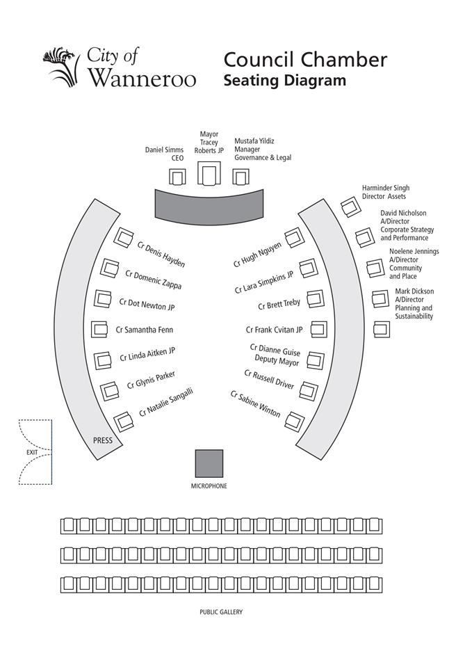
The Council Briefing session will take place in the Council Chamber in the Civic Centre.

Briefing Papers for Tuesday 29 November 2016
CONTENTS
Item 2_____ Apologies and Leave of Absence
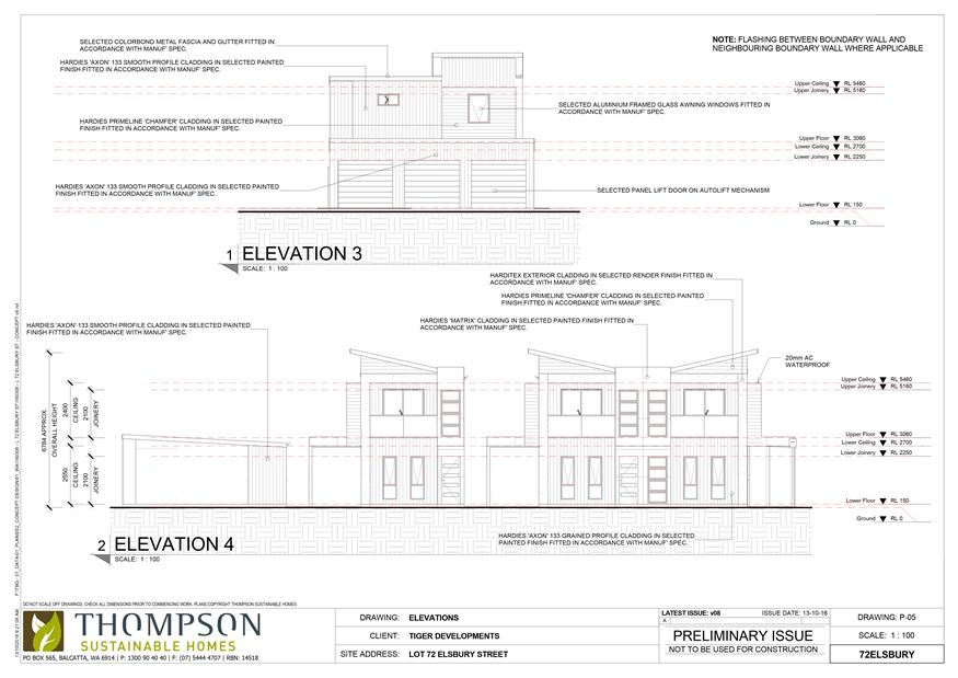
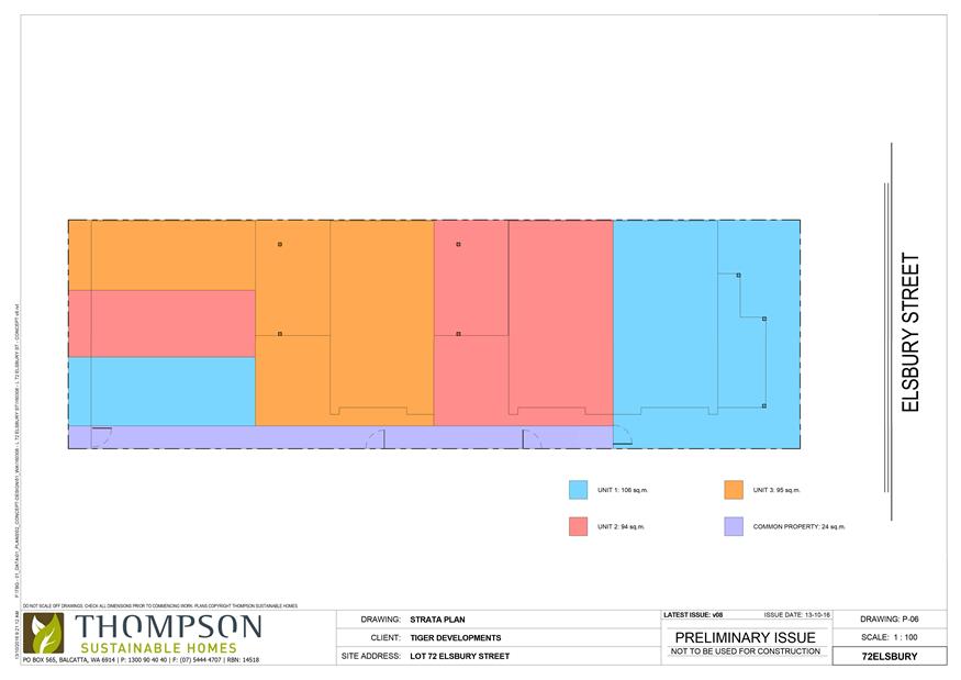
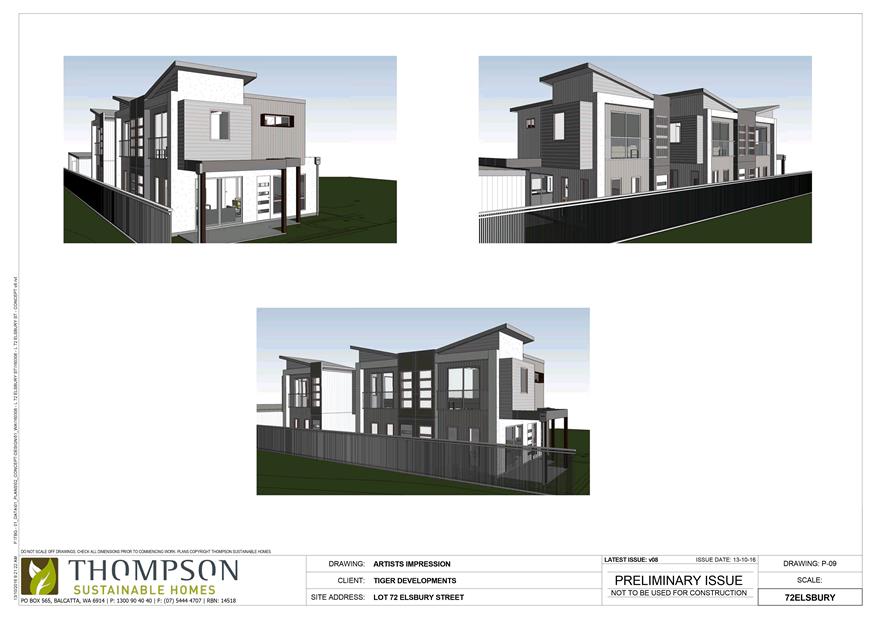
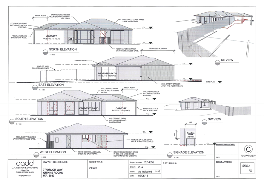
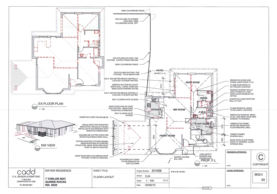
3.1 Adoption of Local Planning Policy 4.20 Split Coded Areas
3.2 Food Truck Trial Summer 2016/17
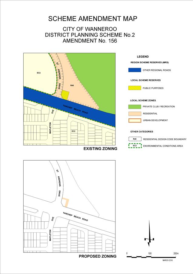
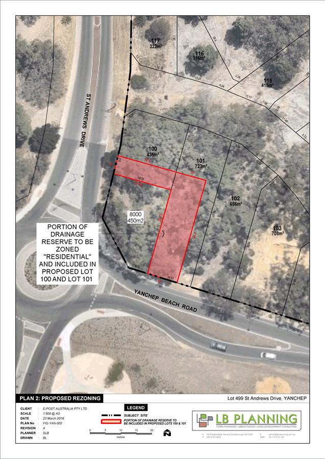
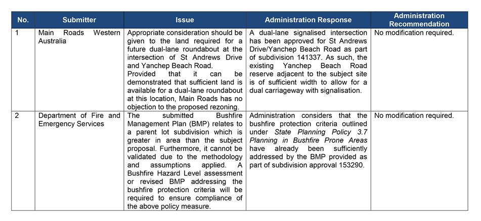
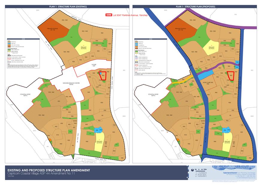
3.10 Amendment No. 156 to District Planning Scheme No. 2 - Lot 499 (144) St Andrews Drive, Yanchep
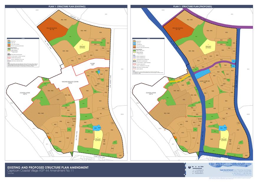
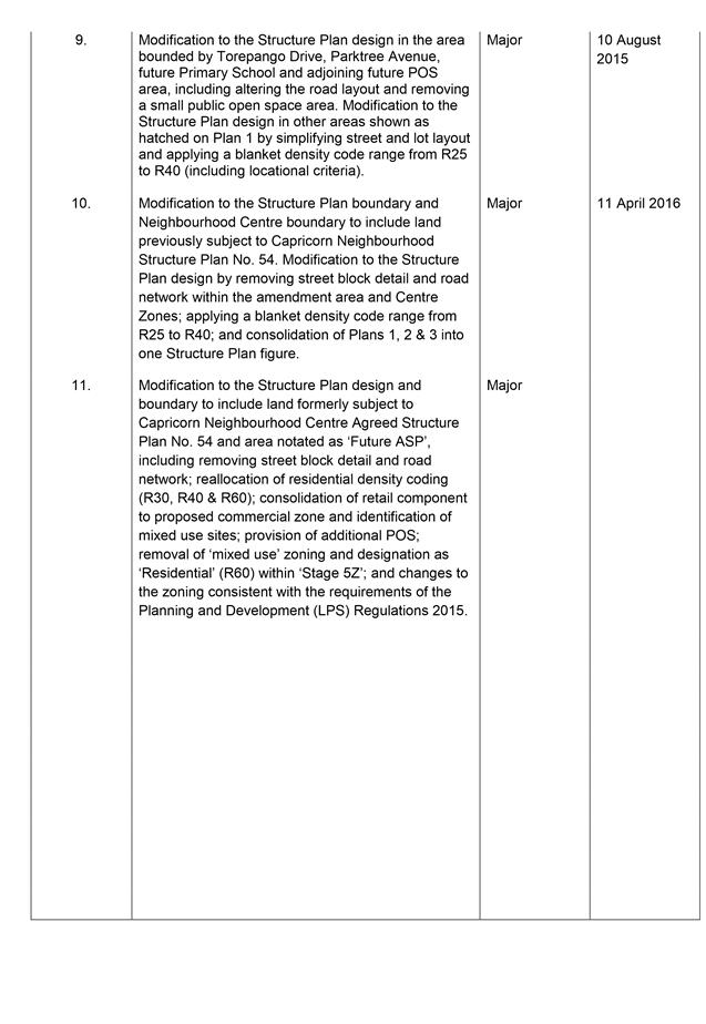
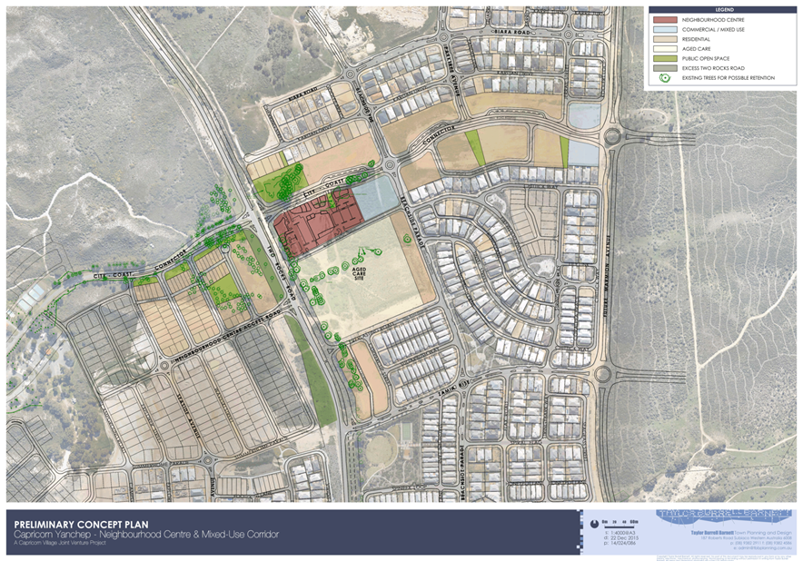
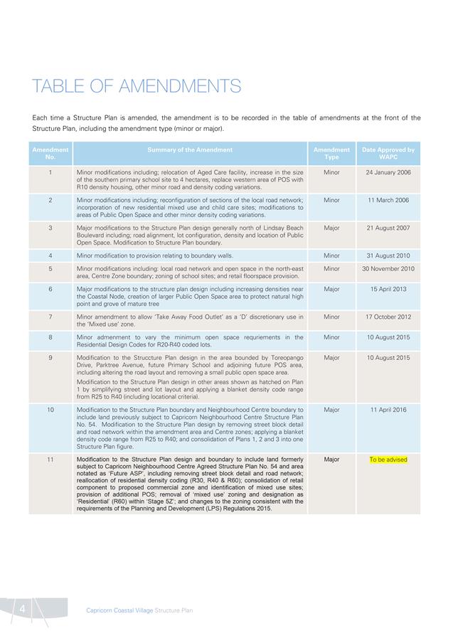
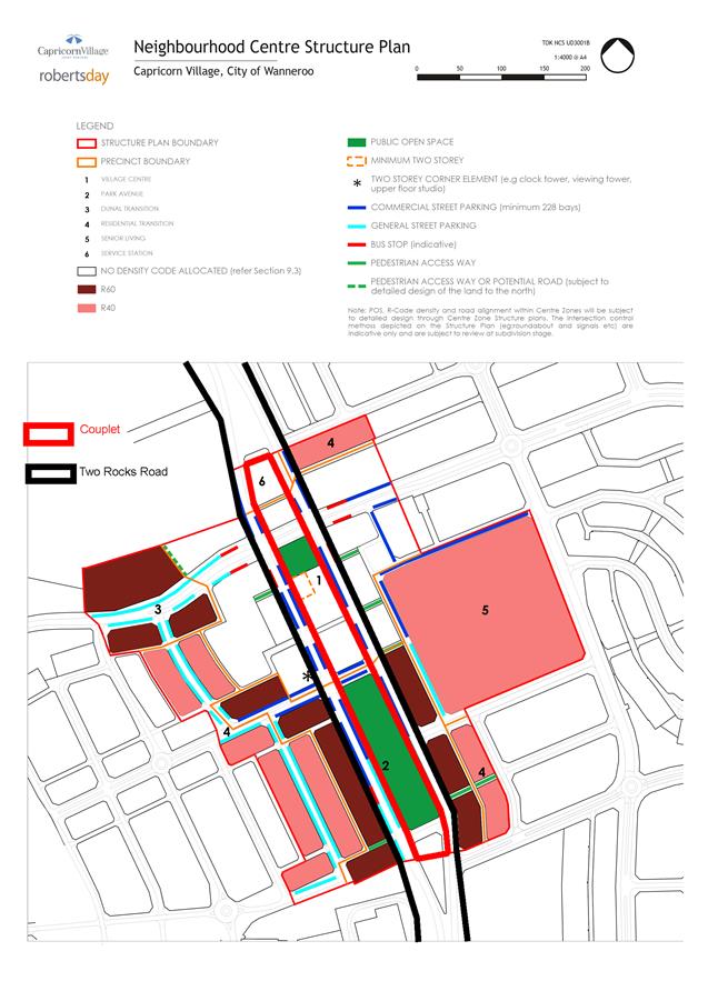
3.11 Adoption of Amendment No. 11 to the Capricorn Coastal Village Agreed Structure Plan No. 44
3.12 Adoption of Local Planning Policy 4.18: Earthworks and Sand Drift
3.13 Local Planning Policy - Compliance 4.14
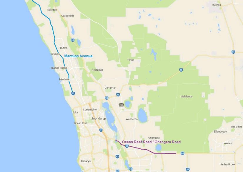
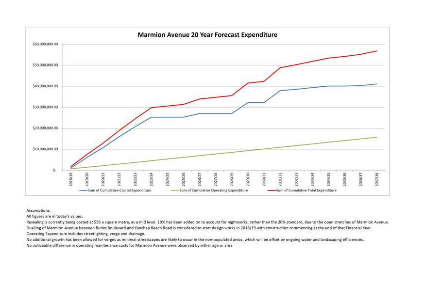
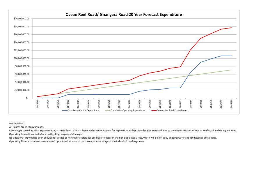
3.14 Reclassification of Marmion Avenue and Ocean Reef Road/ Gnangara Road as State Roads
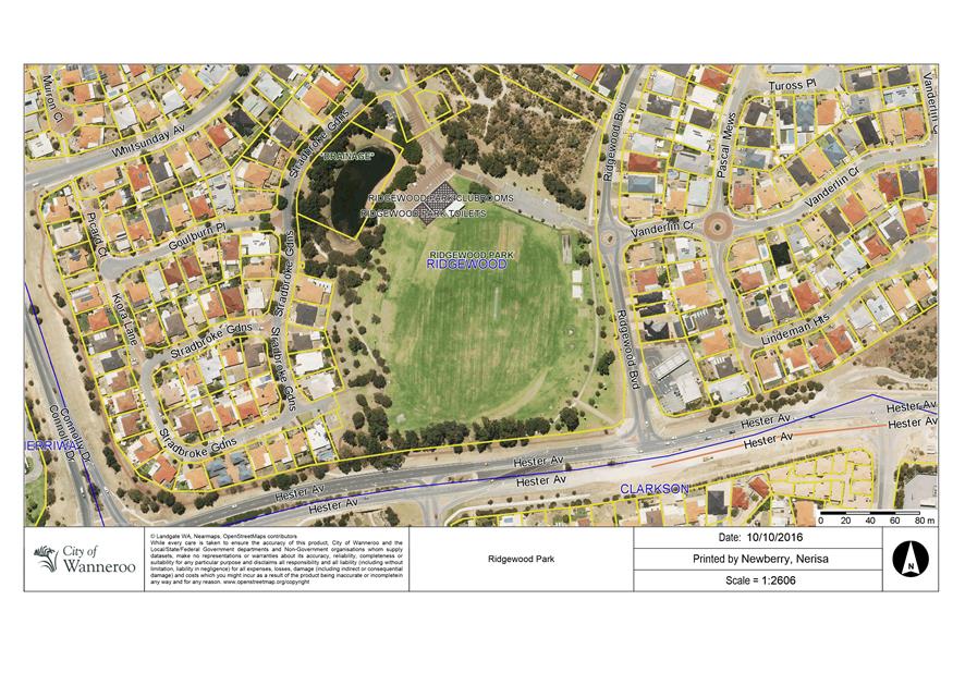
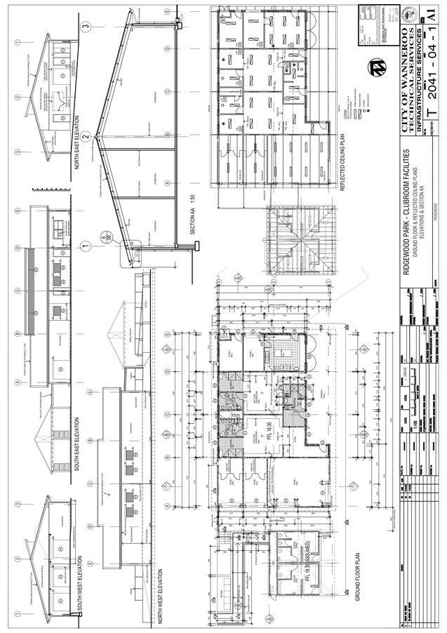
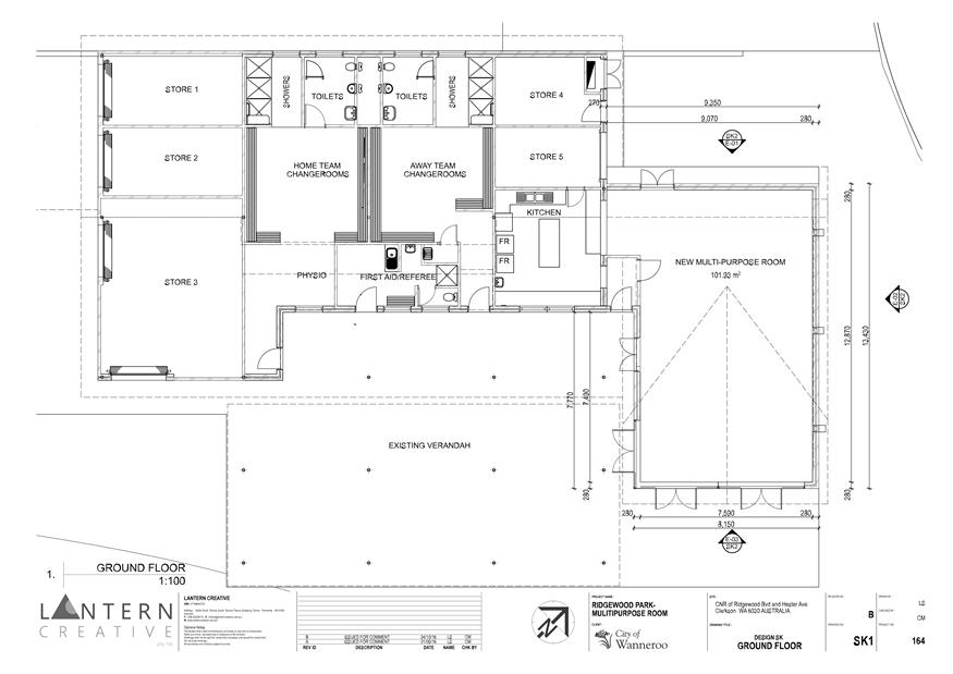
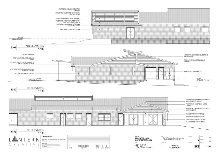
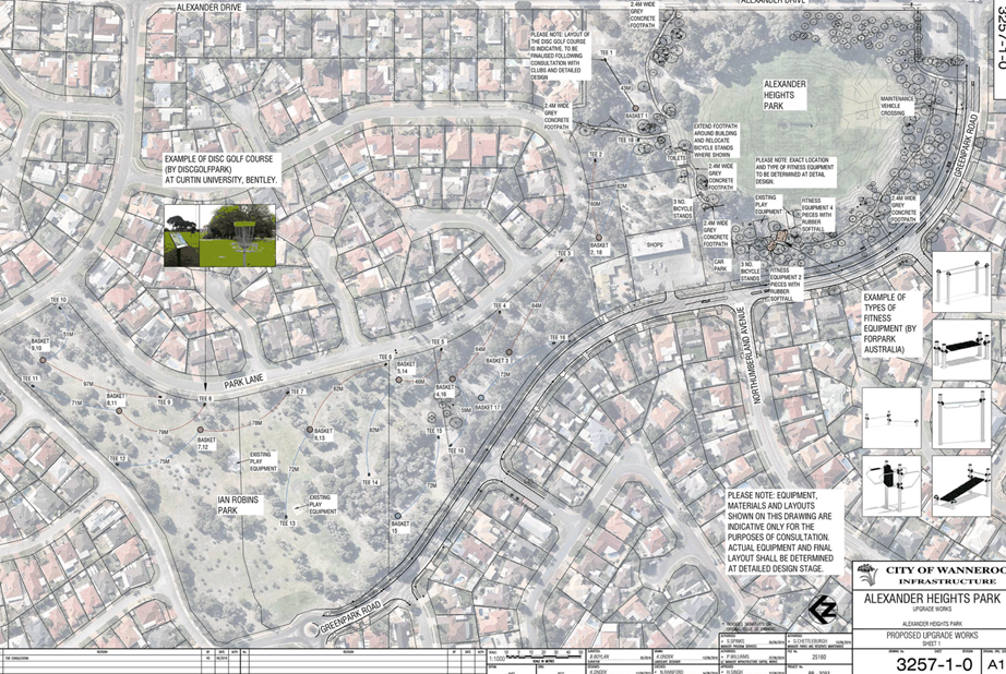
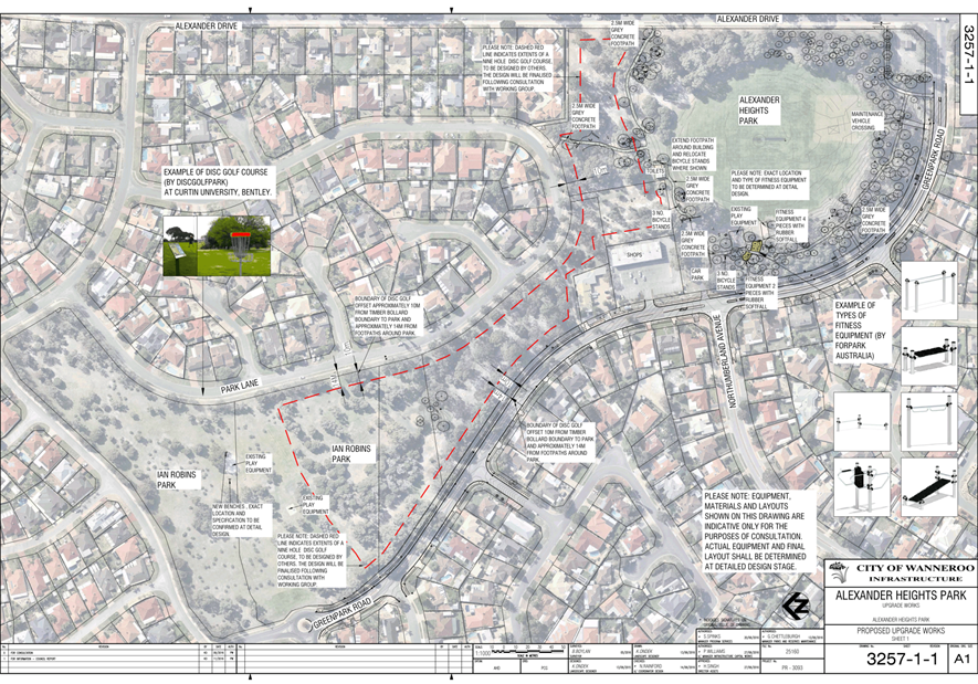
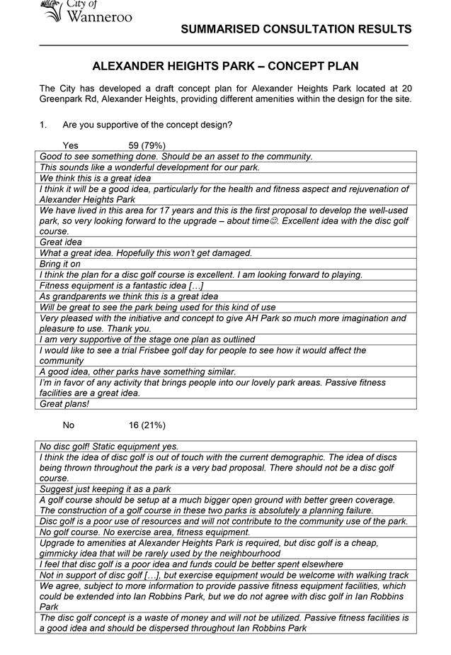
3.15 Ridgewood Clubroom Extension – Concept Design and Consultation Outcomes
3.16 Passive Park Upgrade - Development of Alexander Heights Park
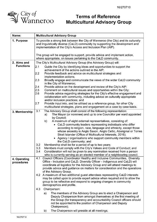
3.17 Establishment of a Multicultural Advisory Group
Corporate Strategy & Performance
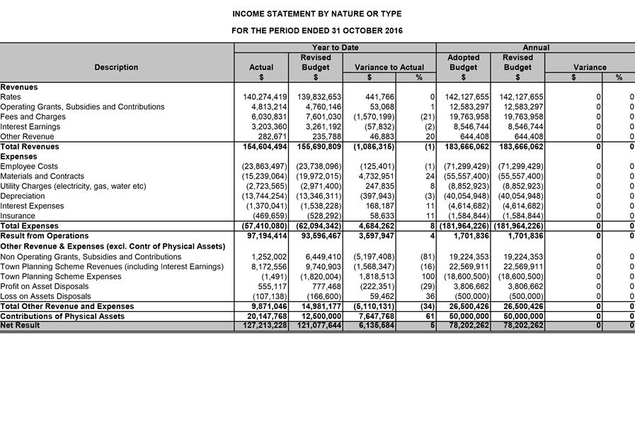
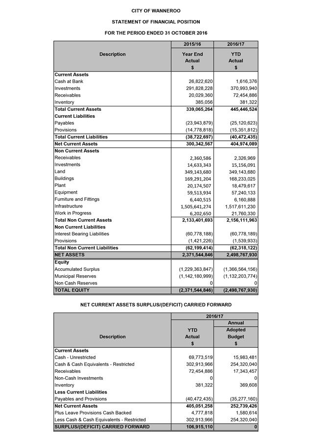
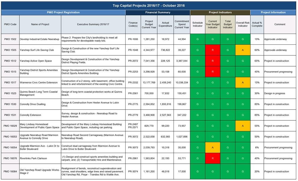
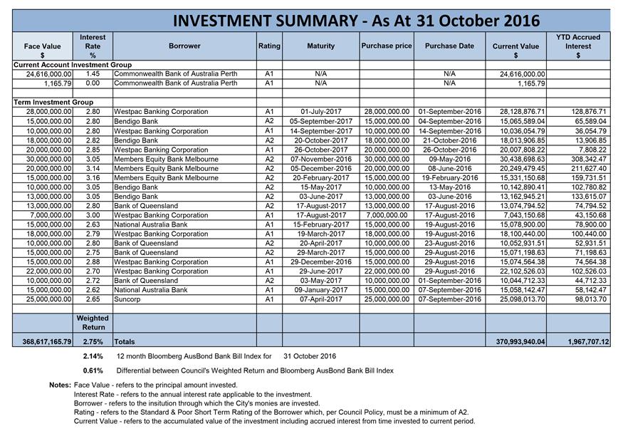
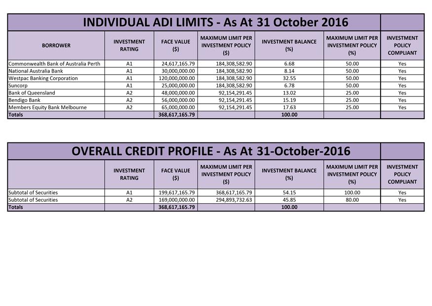
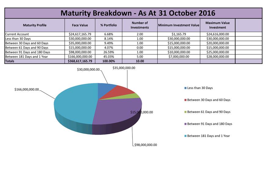
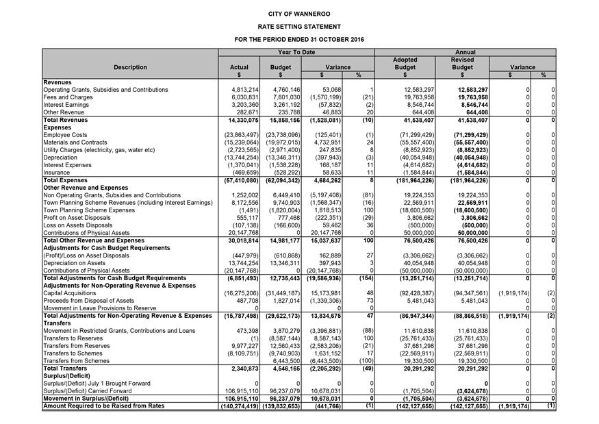
3.18 Financial Activity Statement for the Period Ended 31 October 2016
Customer & Information Services
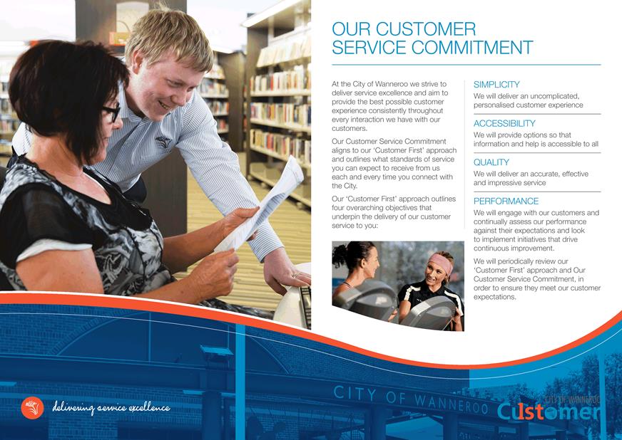
3.19 Our Customer Service Commitment
3.20 Donations to be Considered by Council - December 2016
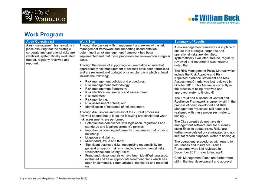
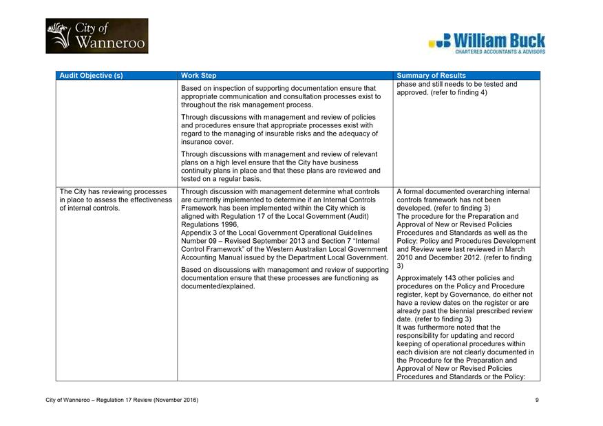
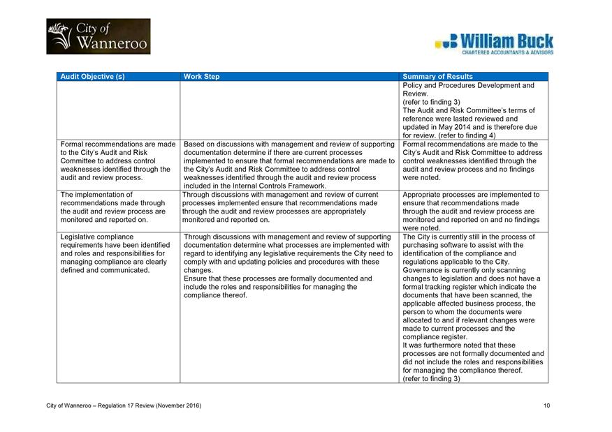
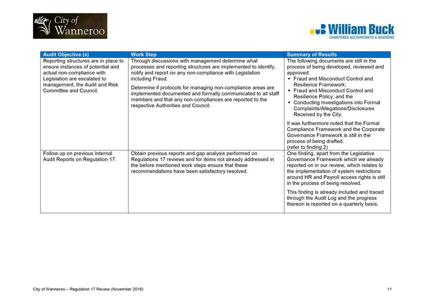
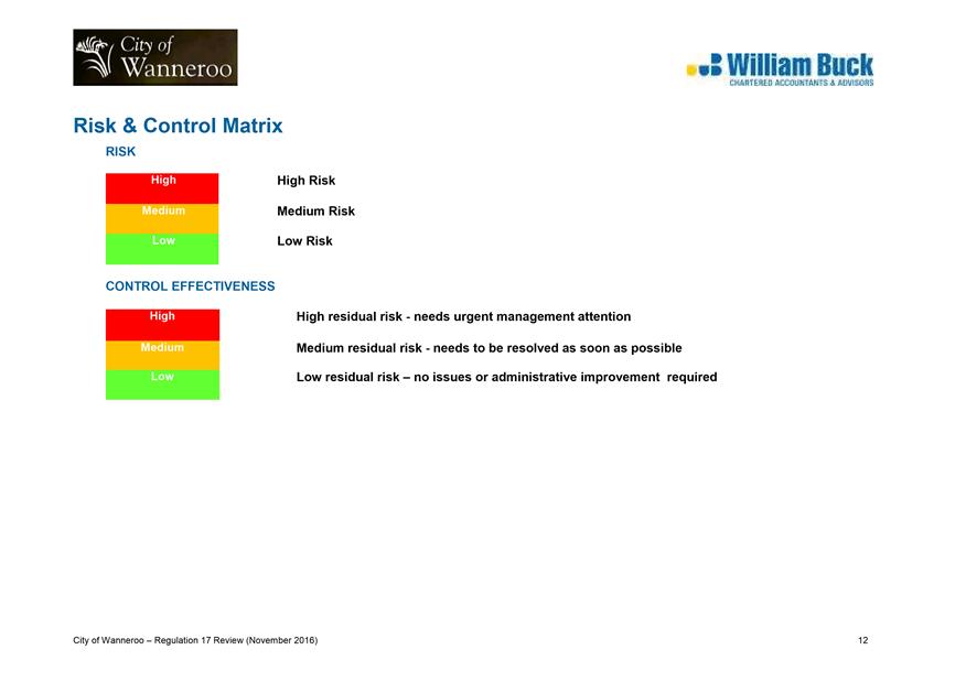
3.21 Internal Audit of Regulation 17 (2016) by William Buck
3.22 Delegation of Authority During the Council Recess Period
3.23 Proposed Amendment to the Public Places and Local Government Property Local Law 2016
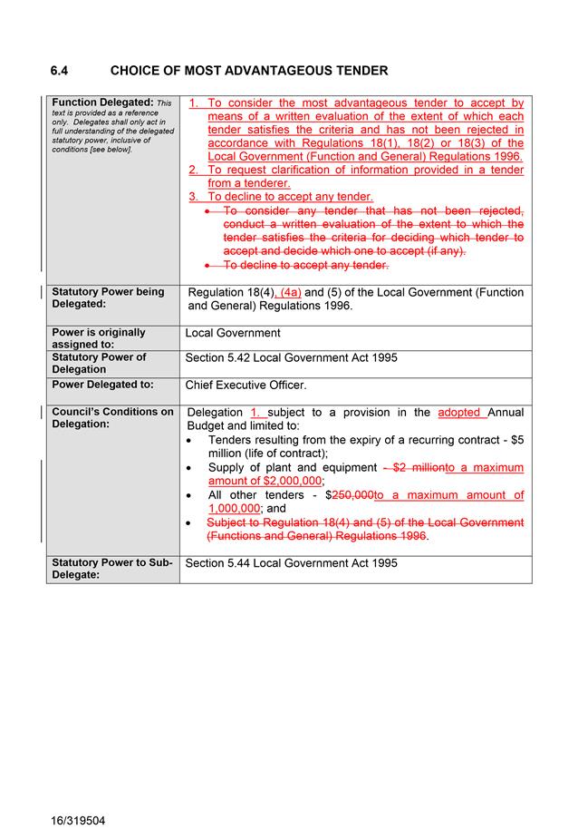
3.24 Amendment to Delegation 6.4 Choice of Most Advantageous Tender
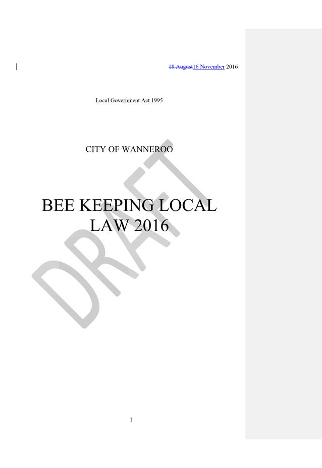
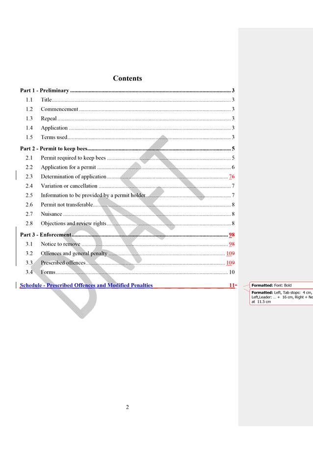
3.25 Adoption of Proposed Bee Keeping Local Law
Item 5_____ Late Reports (to be circulated under separate cover)
5.1 Warrant of Payments for the Period to 30 November 2016
Item 6_____ Public Question Time
Item 8_____ Date of Next Meeting
Agenda
Good evening Councillors, staff, ladies and gentlemen, we wish to acknowledge the traditional custodians of the land we are meeting on, the Whadjuk people. We would like to pay respect to the Elders of the Nyoongar nation, past and present, who have walked and cared for the land and we acknowledge and respect their continuing culture and the contributions made to the life of this city and this region and I invite you to bow your head in prayer:
Lord, We ask for your blessing upon our City, our community and our Council. Guide us in our decision making to act fairly, without fear or favour and with compassion, integrity and honesty. May we show true leadership, be inclusive of all, and guide the City of Wanneroo to a prosperous future that all may share. We ask this in your name. Amen
Item 2 Apologies and Leave of Absence
Declarations of Interest by Elected Members, including the nature and extent of the interest. Declaration of Interest forms to be completed and handed to the Chief Executive Officer.
File Ref: 26112 – 16/295907
Responsible Officer: Operations Manager Planning & Sustainability
Disclosure of Interest: Nil
Attachments: 5
Previous Items Consideration of draft LPP 4.20: Split Coded Areas (PS04-05/16)
Issue
To consider submissions received during the public advertising of draft Local Planning Policy 4.20: Split Coded Areas (LPP 4.20) and adoption of the policy.
Background
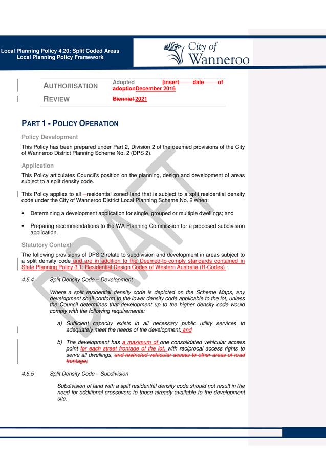
Draft LPP 4.20 was prepared to articulate Council’s expectations with regard to garage design, street surveillance, landscaping and the design of crossovers in split code areas. This followed the Minister for Planning’s final approval of Amendment No. 119 to District Planning Scheme No. 2 (DPS 2), which re-coded the Wanneroo and Girrawheen-Koondoola housing precincts to allow for development at higher residential densities.
At its meeting on 24 May 2016, Council adopted draft LPP 4.20: Split Coded Areas for the purpose of public advertising (PS04-05/16).
At the same meeting, Council also resolved to initiate Amendment No. 158 (PS03-05/16) to recode three properties in Girrawheen, Marangaroo and Wanneroo that were omitted from Amendment No. 119, and to provide for a consolidated vehicle access from each street frontage on corner blocks.
In accordance with Council’s resolution, draft LPP 4.20 (as contained in Attachment 1) was advertised for public comment from 30 May to 22 June 2016.
Administration has been awaiting the final approval of Amendment No. 158 before finalising the provisions of draft LPP 4.20. As Amendment No. 158 has now been approved by the Minister for Planning and notice published in the Government Gazette on 21 October 2016, a draft revised LPP 4.20 is now being presented to Council for final approval.
Detail
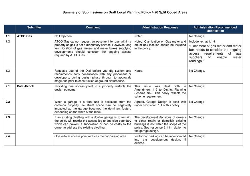
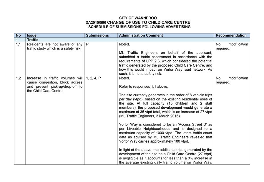
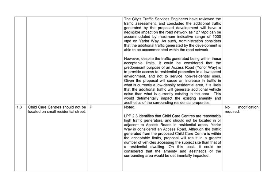
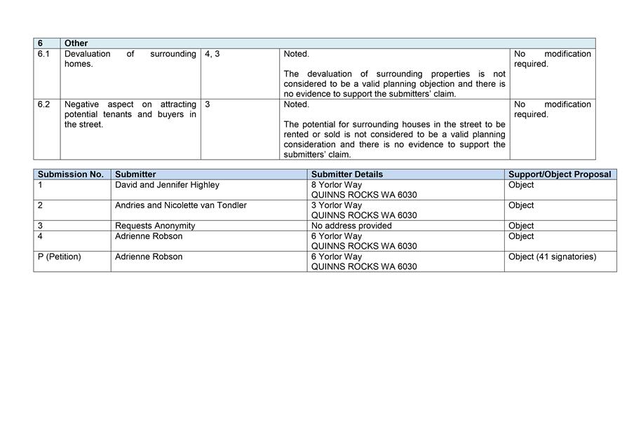
Five submissions were received during the public comment period - two from private companies and three from government agencies. A summary of the submissions received and Administration’s comments and recommended modifications in response to those submissions is included as Attachment 2. An overview of the key issues raised in submissions is outlined below.
· Implications of single vehicular access
The two private company submissions raised concerns that the requirement for a single consolidated vehicle access point would restrict residential design responses on the lot. The resultant reduction in onsite parking and potential increase in street parking was also raised as an issue by one submitter.
The requirement for one single consolidated vehicle access point per lot (and two vehicle access points for corner lots) was introduced into DPS 2 through Amendment No. 119 and Amendment No. 158 respectively, and this issue was dealt with through the finalisation of those amendments. As draft LPP 4.20 is required to be consistent with the provisions of DPS 2, no changes are proposed in response to these submissions.
Notwithstanding the above, the requirement for a single consolidated access point has been accepted by the majority of landowners who have proposed redevelopment in the new split code areas and incorporated into redevelopment designs without issue. In regard to street parking, this is considered to act as a traffic calming measure and is not seen as a negative outcome of higher density.
· Gas Services
The submission from ATCO Gas noted that gas is not a mandatory service and therefore no easement can be requested on private lots. Accordingly, ATCO Gas has requested that consideration be given to including provision in the Policy to address the location of gas meters and meter boxes. As the purpose of draft LPP 4.20 is to guide development in split coded areas, Administration believes that including this information in the Policy will be beneficial to both applicants and Administration. It is therefore recommended that a new clause 1.1.4 be included in the draft revised LPP 4.20 as follows:
“1.1.4 Placement of gas meter and meter box needs to consider the ongoing access requirements of gas suppliers to enable meter readings.”
· Impact on Street Trees
The Department of Planning (DoP) raised concerns relating to development that conflicted with existing street trees. DoP suggested that the City include provisions within draft LPP 4.20 to require the replacement of existing street trees when their removal would result in improved planning outcomes. Administration agrees that protection and preservation of street trees is important, however, this matter is already addressed in the City’s draft Street Tree Policy that was endorsed by Council for public advertising at its meeting on 7 November 2016. It is therefore recommended that the Draft Street Tree Policy be included in the list of ‘Other Documents’ referred to in draft LPP 4.20.
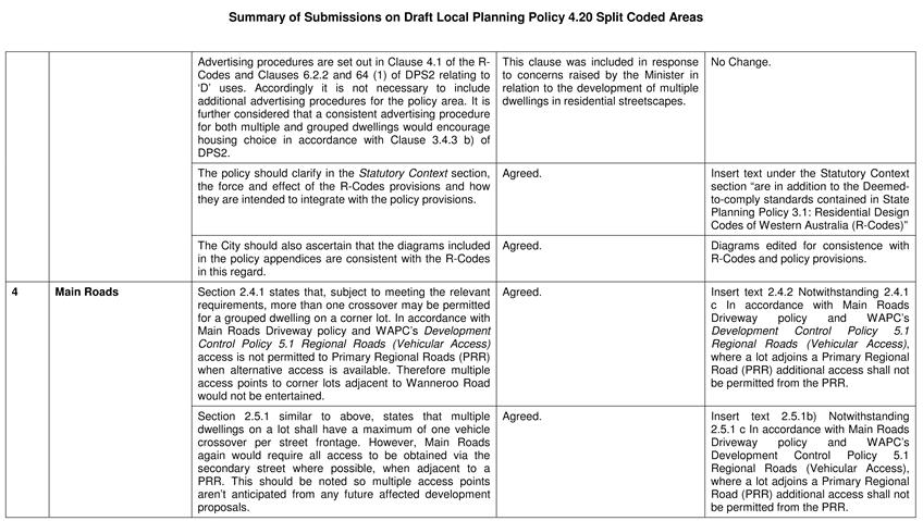
· Advertising Requirements
The submission from the DoP also questioned the requirement for public advertising of multiple dwelling proposals within split coded areas. DoP felt that consistent advertising procedures for both multiple and grouped dwellings would encourage greater housing choice.
The requirement for advertising of multiple dwelling proposals was included in draft LPP 4.20 to address concerns raised by the Minister for Planning around the time that Amendment No. 119 was being assessed by the DoP. These concerns stemmed from issues being experienced in other Local Government areas in relation to the impact of multiple dwellings on residential streetscapes.
No changes are recommended in response to the DoP submission on this matter, as Administration considers it appropriate for multiple dwelling proposals to be given greater scrutiny through advertising and public consultation because of the potential impact on the surrounding area, at least in the early stages of redevelopment in split-code areas.
However, the DoP submission did suggest some clarification be included in the draft Policy about the relationship between the R-Code provisions and LPP 4.20. This is supported by Administration, and it is proposed to amend the first paragraph under the ‘Statutory Context’ section to read as follows:
“The following provisions of DPS 2 relate to subdivision and development in areas subject to a split density code and are in addition to the Deemed-to-comply standards contained in State Planning Policy 3.1: Residential Design Codes of Western Australia (R-Codes).”
· Consistency with the R-Codes
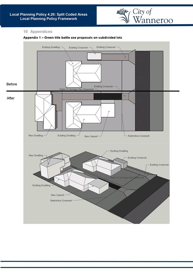
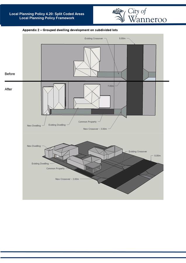
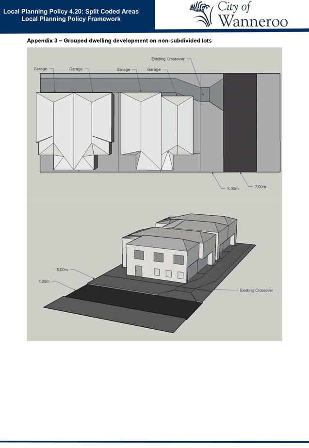
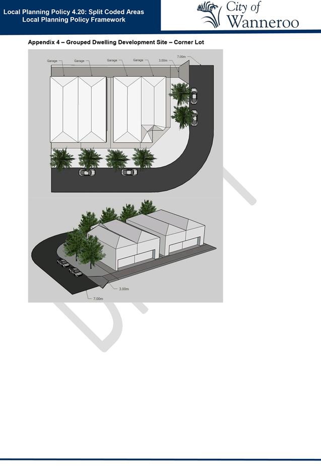
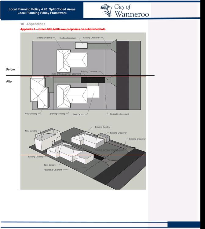
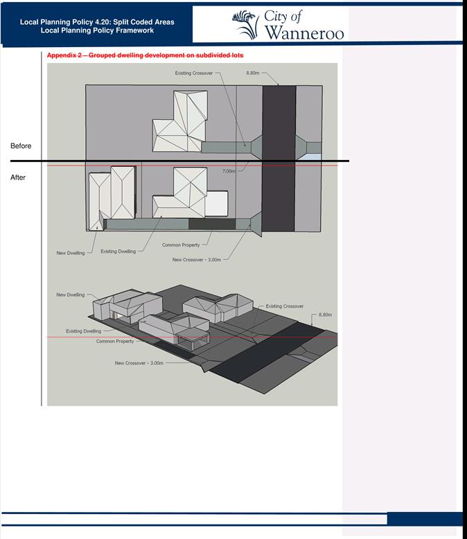
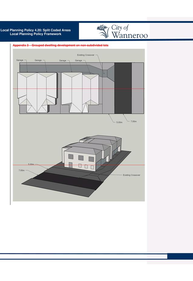
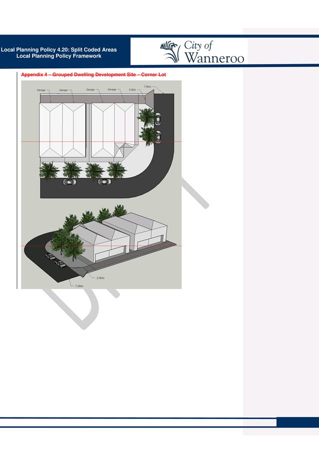
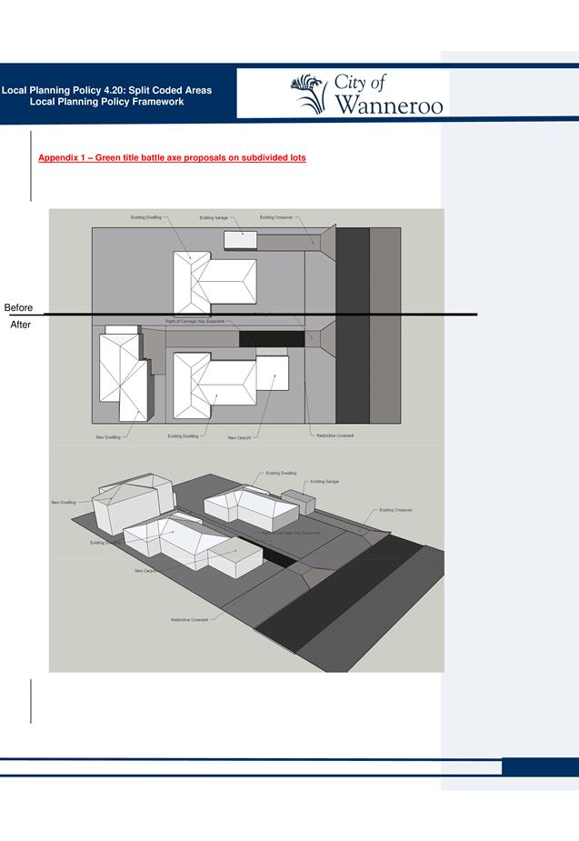
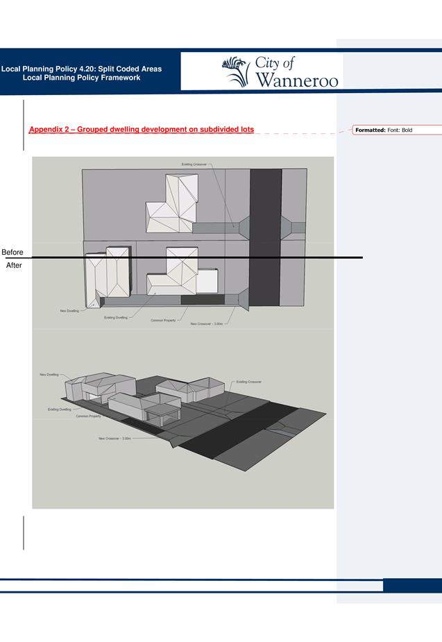
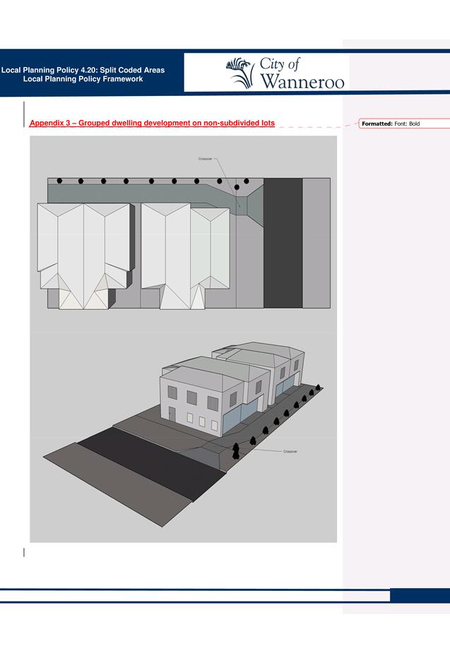
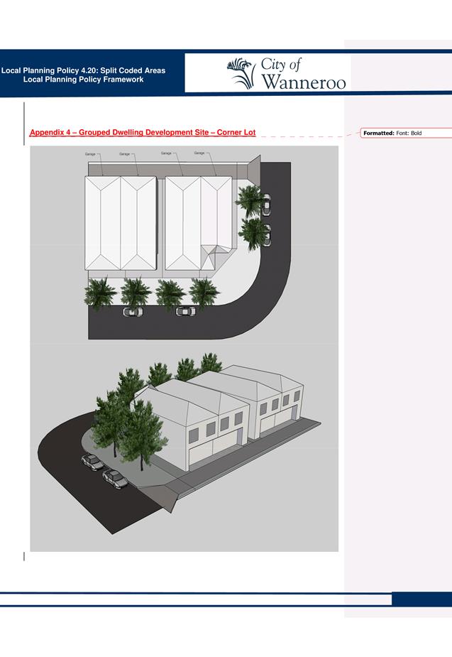
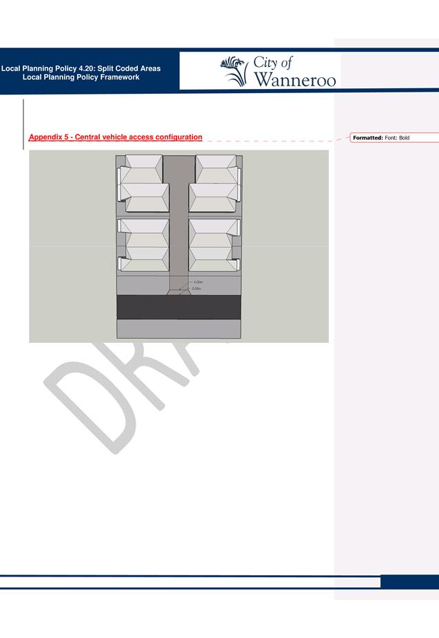
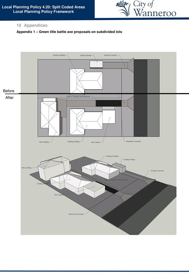
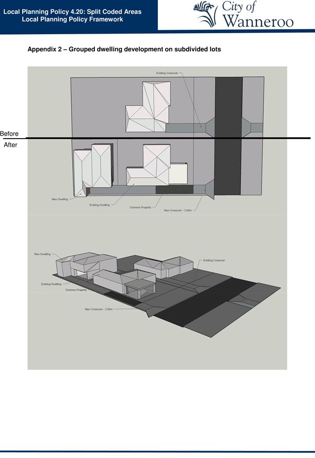
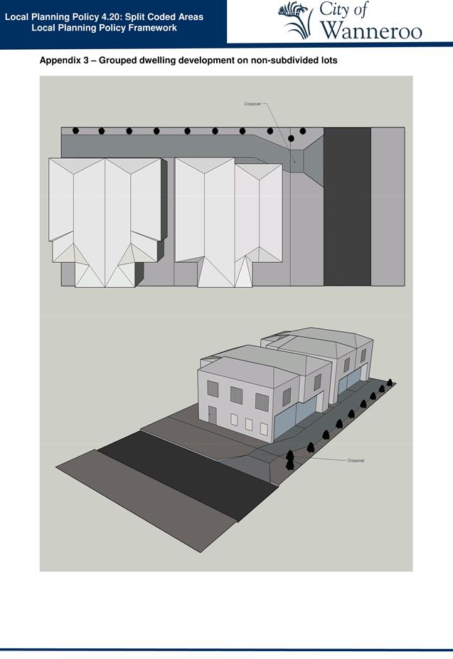
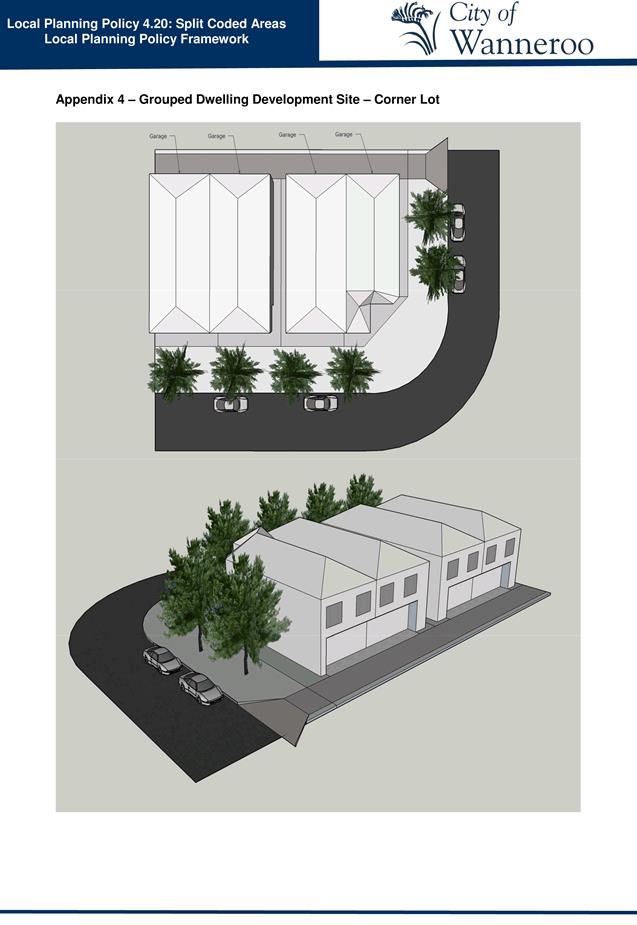
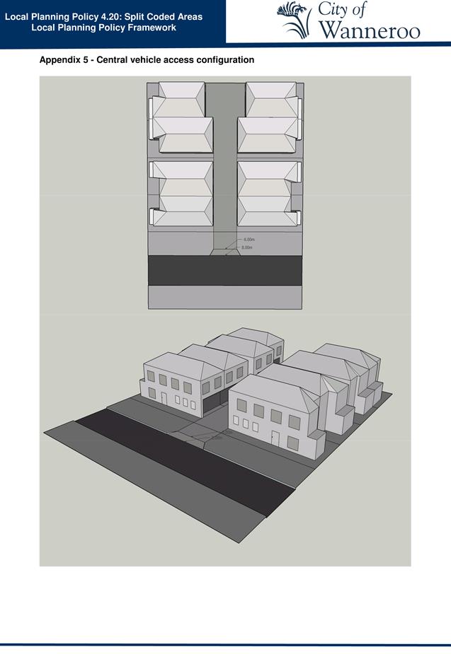
The DoP submission suggested that the diagrams in the draft LPP 4.20 appendices be amended to be consistent with the R-Codes. Administration has reviewed the diagrams and is proposing that a number of minor changes be made to ensure consistency between with the R-Codes and LPP 4.20. These changes include reflecting boundary setbacks as per the R-Codes, illustrating landscaping requirements as per LPP 4.20 and removing superfluous labels such as road width. Administration does not believe that these changes alter the intent of the Policy but rather reinforce the policy alignment with the R-Code provisions.
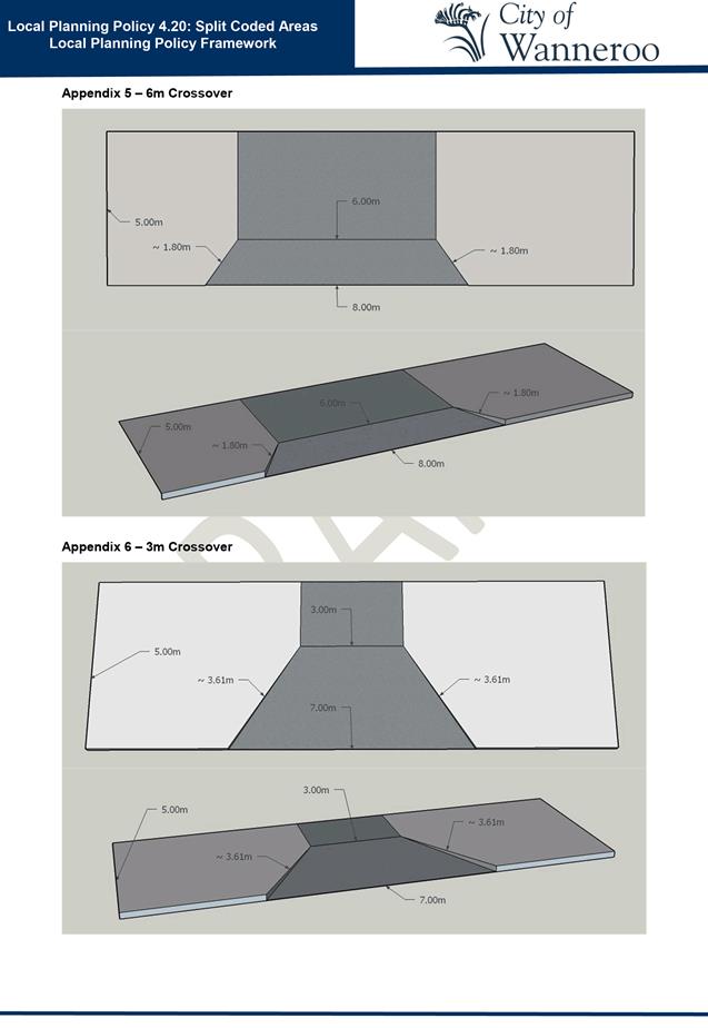
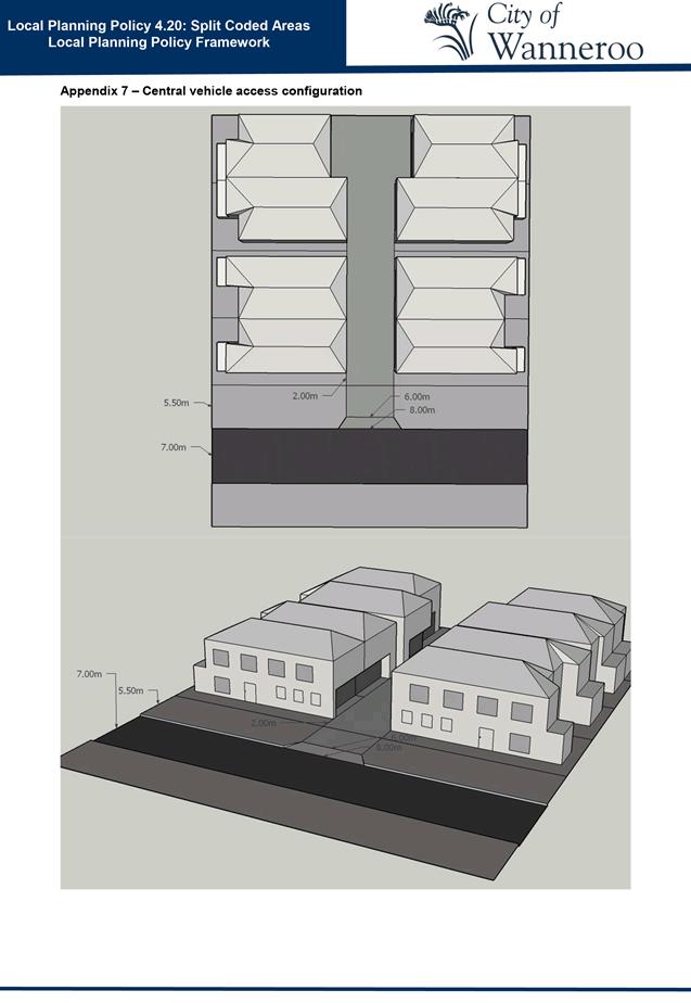
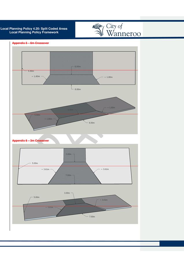
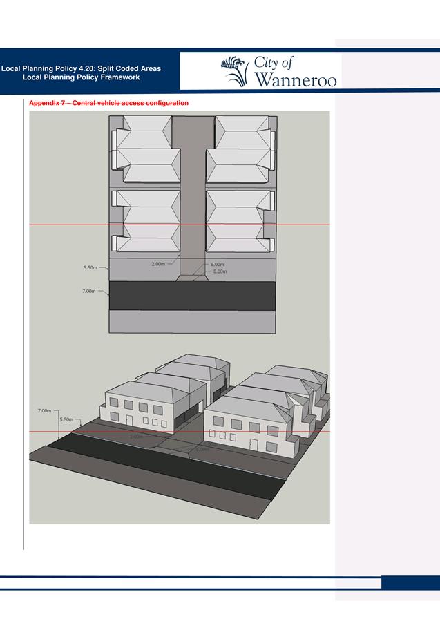
Administration also removed Appendices 5 and 6 and amended all references to these Appendices within the text of the amended draft LPP4.20 to refer to “the City’s Standard Drawings”. This also required amending Appendix 7 from the advertised draft to Appendix 5 in the revised draft LPP 4.20. This will allow for the changes to the City’s Standard Drawings without requiring changes to LPP 4.20.
· Access from Primary Regional Roads
The submission from Main Roads raised concerns regarding vehicle access points being allowed from each street frontage of corner blocks, where the blocks are located adjacent to Primary Regional Roads (PRR) such as Wanneroo Road. In accordance with the Main Roads Driveway Policy and the WAPC’s Development Control Policy 5.1: Regional Roads (Vehicle Access), access is not permitted from a PRR when alternative access is available.
Administration agrees, and recommends that a new clause 2.4.2 be included in draft revised LPP 4.20 as follows:
“2.4.2 Notwithstanding 2.4.1, in accordance with Main Roads Driveway Policy and WAPC’s Development Control Policy 5.1 Regional Roads (Vehicle Access), where a lot adjoins a Primary Regional Road (PRR) additional access shall not be permitted from the PRR.”
It is also proposed to include this text in a new clause 2.5.2, to ensure the requirement also applies to multiple dwellings in addition to grouped dwellings, in draft revised LPP 4.20.
Administration Modifications
In addition to the modifications recommended in response to submissions received during the public consultation period, Administration has identified a number of additional modifications to be made to draft LPP 4.20 a summary of these is provided as Attachment 3, and are outlined below:
· Purpose
The wording of the Purpose section in the Draft LPP4.20 included references to the objectives of LPP 4.20 which are also covered in the Objectives section. To make the purpose of LPP 4.20 clearer, Administration recommends removing these references to the objectives. The new purpose is proposed to read:
“The purpose of this policy is to ensure infill development has a positive impact on the streetscape.”
· Provision for an additional vehicle access point for corner lots
The final approval of Amendment No. 158 by the Minister for Planning amended the provisions of DPS 2 to provide for a maximum of one consolidated vehicle access point for each street frontage in split coded areas. This means that corner lots can now be developed with vehicle access points from each street frontage, whereas they were previously restricted to a single access point for the lot. Administration therefore proposes that all references to a single vehicle access point in the draft LPP 4.20 be amended to reflect this updated DPS 2 provision.
· Draft Apartment Design Policy
Administration recommends the recently released draft “Volume Two of State Planning Policy No 7.3 Residential Design Codes Guidance for multiple-dwelling and mixed-use development” be included in the Other Document section of LPP 4.20 to assist applicants in preparing development applications for multiple-dwelling development.
· Utilities
Clause 4.5.4(a) of DPS 2 requires sufficient capacity to exist in all necessary public utility services for development to occur at the higher density code. Confirmation from the Water Corporation regarding required upgrades will be required with development applications. Western Power advised the City that they did not have a process in place to confirm whether there is sufficient capacity in their network prior to the lodgement of a development application. Additional demands on their network that may result from infill development is considered as part of their forward planning and electricity load forecasting, and this forms the basis of their network upgrade program. Accordingly, no confirmation of servicing capacity would be required by the City from Western Power to support a development application.
Administration recommends adding the following text to LPP 4.20 to clarify the requirements of provision 4.5.4(a) of DPS 2, as follows:
“1.1.2 Confirmation of works required to accommodate the needs of the development from the Water Corporation is required with the development application.
1.1.3 Confirmation of works is not required from Western Power.
Comment
The submissions made by State government departments raised no objections to draft LPP 4.20, but suggested some minor modifications for improvement. The concerns raised by submissions from private companies related mainly to the requirements of the scheme provisions previously introduced to DPS 2 by Amendment No. 119 and Amendment No 158, which cannot be further entertained through the preparation of this Policy.
The proposed modifications made in response to submissions, and the additional changes proposed by Administration are considered to be minor in nature and aim to ensure that the Policy will provide more clarity to applicants and guide development in split coded areas to deliver better streetscape amenity, functionality and adaptability.
Due to the minor nature of the proposed changes it is not deemed necessary to readvertise the amended draft LPP 4.20.
A track changes version of the revised draft LPP4.20 is included as Attachment 4.
A copy of LPP 4.20 for Council’s consideration, with all recommended modifications accepted, is included as Attachment 5.
Consultation
Draft LPP 4.20 was advertised for public comment from 30 May 2016 to 22 June 2016 by way of:
· Advertisements in local newspapers;
· A notice of the proposal in Council offices and on the City’s website; and
· Referral in writing to affected persons or agencies as determined by the Director Planning and Sustainability.
Statutory Compliance
In accordance with clause 4(3) of the Deemed Provisions of DPS 2, Council is required to review the draft Policy in light of any submissions made and must then resolve either to finally adopt the draft Policy with or without modification, or not to proceed with the draft Policy.
In accordance with clause 4(4) of the Deemed Provisions of DPS 2, should Council resolve to finally adopt LPP 4.20, notification of the Policy’s final adoption must be published once in a newspaper circulating in the Scheme area.
In accordance with clause 4(6) of the Deemed Provisions of DPS 2, should Council resolve to finally adopt LPP 4.20, a copy of the adopted Policy must be made available for public inspection at the Civic Centre during business hours.
Strategic Implications
The proposal aligns with the following objective within the Strategic Community Plan 2013 – 2023:
“2 Society - Healthy, safe, vibrant and active communities.
2.1 Great Places and Quality Lifestyle - People from different cultures find Wanneroo an exciting place to live with quality facilities and services.”
Risk Management Considerations
|
Risk Title |
Risk Rating |
|
CO-O01 Relationship Management |
Moderate |
|
Accountability |
Action Planning Option |
|
Executive Management Team |
Manage |
|
Risk Title |
Risk Rating |
|
CO-O03 Land Development |
Moderate |
|
Accountability |
Action Planning Option |
|
Executive Management Team |
Manage |
The above risks relating to the issue contained within this report has been identified and considered within the City’s Corporate risk register. Action plans have been developed to manage this risk to support existing management systems.
Policy Implications
Pursuant to Clause 4 of the Deemed Provisions of DPS 2, if Council resolves to adopt LPP 4.20, it will become an operative local planning policy that the City must have regard to when making determinations under DPS 2.
Financial Implications
The cost of publishing a notice of the Policy’s adoption can be met from existing operational budgets.
Voting Requirements
Simple Majority
Recommendation
That Council:-
1. NOTES the submissions received regarding the draft Local Planning Policy 4.20 Split Coded Areas and ENDORSES Administration’s responses and recommended modifications, as included in Attachment 2;
2. NOTES and ENDORSES Administration's proposed modifications in respect to draft Local Planning Policy 4.20: Split Coded areas, as included in Attachment 3;
3. Pursuant to Clause 4(3)(b)(ii) of the Deemed Provisions of City of Wanneroo District Planning Scheme No. 2, ADOPTS Local Planning Policy 4.20: Split Coded Areas, included as Attachment 5; and
4. Pursuant to Clause 4(4) of the Deemed Provisions of District Planning Scheme No. 2 PUBLISHES notice of its adoption of Local Planning Policy 4.20: Split Coded Areas in the Wanneroo Times, FORWARDS a copy of the adopted Policy to the Western Australia Planning Commission for its information and ADVISES submitters of Council’s decision.
Attachments:
|
1⇩. |
Draft LPP 4.20 Split Coded Areas April 2016 |
16/142824 |
|
|
2⇩. |
Attachment 2 to Council Report 16/295907 Summary of Submissions on Draft Local Planning Policy 4.20 Split Coded Areas.docx |
16/391177 |
Minuted |
|
3⇩. |
Proposed Administrative Changes to LPP4.20 Split Coding Draft Policy.DOCX |
16/398639 |
Minuted |
|
4⇩. |
Track Changes Draft Local Planning Policy 4.20 Split Coded Areas.DOC |
16/393231 |
|
|
5⇩. |
Draft for adoption LPP4.20 Split Coded Area.DOC |
16/393248 |
Minuted |
CITY OF WANNEROO Agenda OF Elected Members' Briefing Session 29 November, 2016 59
File Ref: 27790 – 16/392039
Responsible Officer: Director Planning & Sustainability
Disclosure of Interest: Nil
Attachments: 3
Issue
To consider a six month Food Truck Trial for the summer season 2016/17.
Background
The growing popularity of food trucks in and around the Perth Metropolitan area has seen the City receive numerous requests for food truck trading in public spaces. It is therefore timely for the City to consider conducting a Food Truck Trial during the summer months commencing in mid- December and running through to mid-June.
A ‘food truck’ is any registered vehicle, caravan, trailer or any other method of transport from which food is sold. Food trucks differ from itinerant vehicles (such as ice-cream trucks and ‘Jiffy’ vans) which travel from place to place to engage trade but are only permitted to remain in a place to execute a sale and then must move on. Although temporary in nature, food trucks are permitted to stay in one place for extended periods of time (a number of hours) regardless of whether a sale is taking place.
Food Trucks operating within the City could provide numerous social and economic benefits as outlined below:
• Activation of underutilised Public Open Space (POS) ;
• Creation of more vibrant and distinctive places within the City’s suburbs;
• Fostering greater community interaction and cohesion;
• Opportunity for healthy living by providing dining destinations within walking distance for residents;
• Providing appropriate trading places for small businesses;
• Facilitation of business growth by allowing incubation of emerging businesses in a lower risk environment; and
• The City increasing its reputation as innovative and progressive, by embracing and promoting emerging business and cultural trends.
The proposed trial will facilitate regular trading of food trucks within some of the City’s POS and car parks. There are a number of elements to the proposed trial, and these are outlined in the Detail section below.
Detail
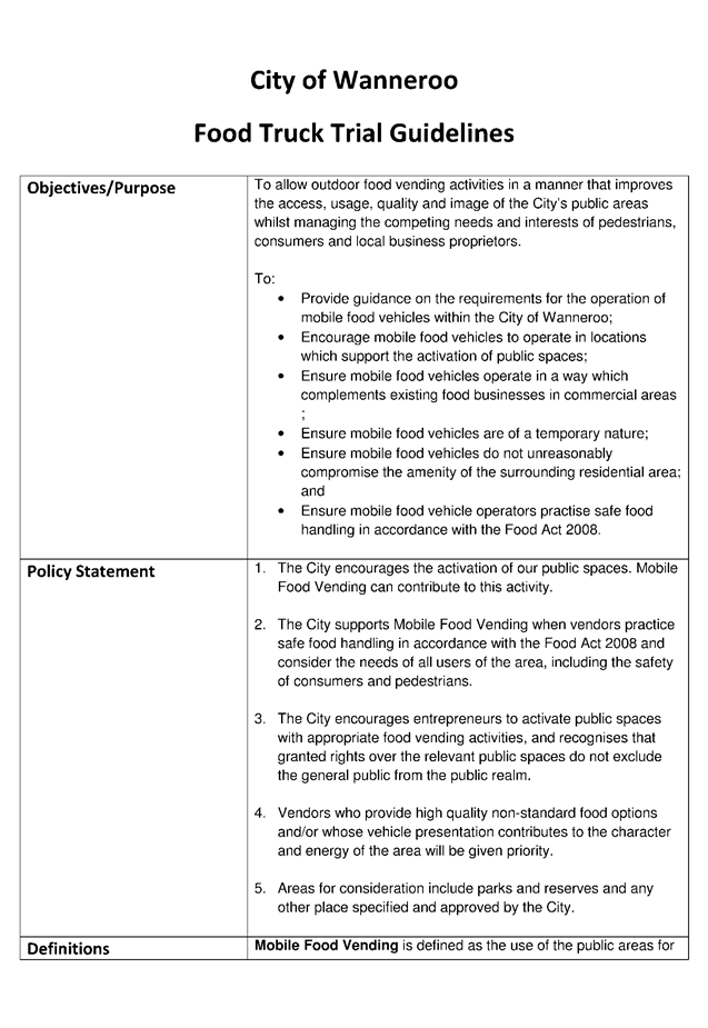
Food Truck Trial Guidelines
Administration has prepared a set of draft Food Truck Trial Guidelines (included as Attachment 1). The Guidelines are aimed at delivering social and economic benefits while at the same time ensuring the City’s assets are protected from damage and undue increases in maintenance. The Guidelines provide a clear framework for Administration and participating food truck operators on how the trial will operate. These guidelines will be reviewed at the end of the trial and may form the basis of any future food truck policy.
Trading in Public Places
The City’s ‘Public Places and Local Government Property Local Law 2015’ stipulates that a trading licence is required for trading in public places (City owned and managed land). The draft Food Truck Guidelines elaborate on the application process and specify conditions for the trial.
Requirement for Development Approval
District Planning Scheme No. 2 (DPS No.2) Deemed Provisions require planning approval for any temporary use that is in existence for more than 48 hours in any 12 month period. However, clause 61 (2)(d) of DPS 2 states that a longer period than 48 hours can be agreed by the Local Government, meaning that applications would not be required to be lodged. For the purpose of the trial, it is proposed to allow the trading of approved food trucks within specific trading zones for more than 48 hours within a 12 month period without the requirement for individual operators to obtain planning approval. Administration considers a resolution of council would satisfy this requirement and recommends Council:
“RESOLVE that no development application is required for any food trucks associated with the 2016/17 Summer Food Truck Trial in accordance with Clause 61(2)(d) of the City of Wanneroo District Planning Scheme No. 2.”
Food Truck Trial
The trial proposes to allocate specific trading zones and hours of trade as well as limiting the number of food trucks allowed at each location at any one time. Initially the City would pre-approve a small number of trading zones throughout the City, but this may be adjusted throughout the trial period if necessary. Clause 11(10) of the Food Truck Trial Guidelines states if a site is deemed unsuccessful at any point during the trial period then it can be removed from the trial at that time. The entire trial many be concluded at any point under Clause 11(11) of the guidelines.
It is proposed that the trial would run in each of the wards, testing two models of operation as follows:
Model One
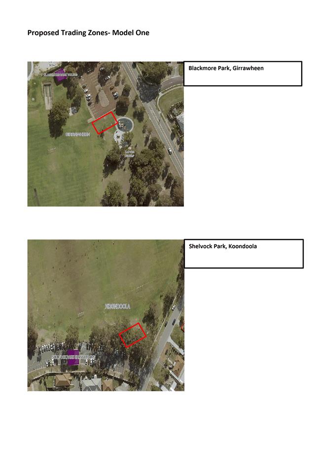
The first model is a small trial proposed to operate in the South Ward supporting a small business operator based there. The small business operator would organise and promote food trucks in three specific locations on set days. The small business operator is proposing to organise food trucks at sites within a larger ‘whole of Perth plan’. The City would grant the small business operator rights to organise food trucks at 3 specific locations once a fortnight, at the exclusion of other Food Truck vendors.
The proposed sites identified for this model are:
|
Site |
Location |
Number of Food Trucks permitted |
|
Blackmore Park |
Girrawheen |
5 |
|
Shelvock Park |
Koondoola |
5 |
|
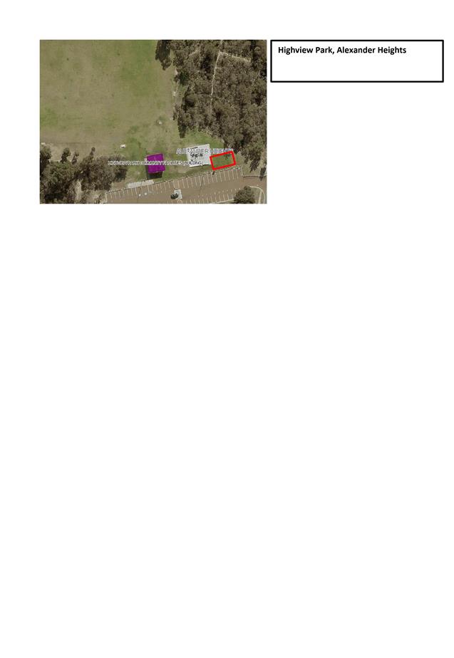
Highveiw Park |
Alexander Heights |
5 |
A map of the proposed trading zones within these sites is included as Attachment 2. The food trucks must still register with the City to participate in the trial and hold all permits required to operate a food business, however the organisation and rostering of the food trucks and promotion would be coordinated through the small business operator.
Model Two
The second model is proposed to operate in all wards and is based on a similar trial model run by the City of Vincent prior to them adopting a policy to allow food trucks to operate on their Public Open Space (POS). The trial is conducted at pre-approved trading zones, with each trading zone having specific trading hours and a limited number of trucks.
The City has identified a number of suitable sites based on the following criteria:
· Located a minimum 500m from an existing food outlet (including commercial and club run canteens);
· Located away from community facilities to avoid parking conflicts and disruptions to facility hirers;
· Easy access from main roads;
· Proximity to residential housing; and
· High visibility to maximise passing trade.
Some indicative sites identified for this model are listed below, with the final selection of sites to be confirmed after onsite investigations if the trial is approved:
|
Site |
Location |
Number of Food Trucks permitted |
|
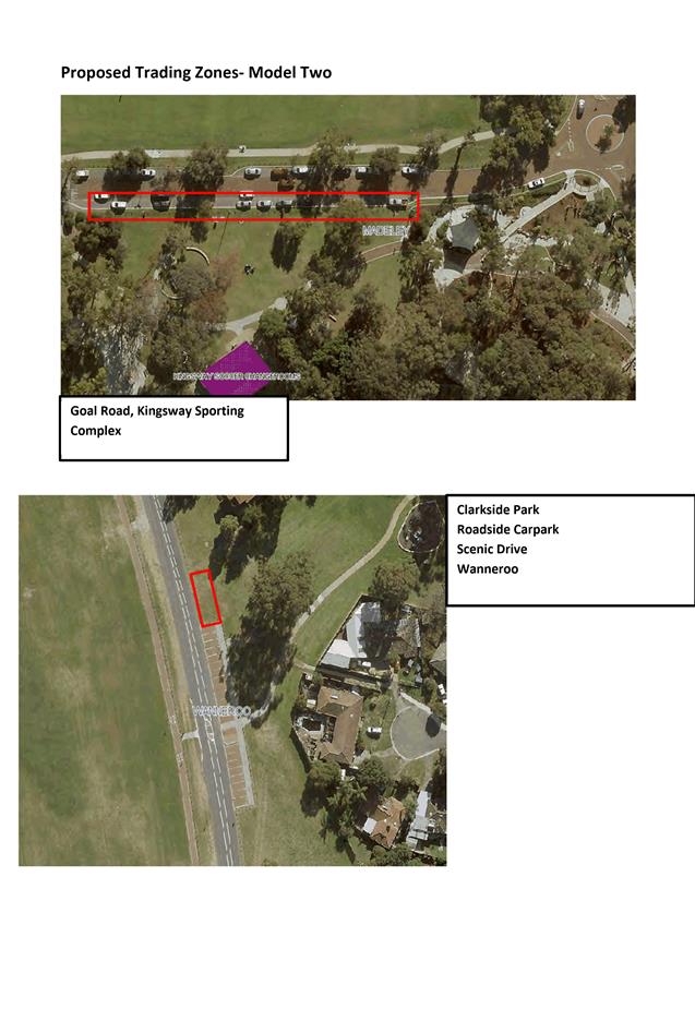
Goal Ave, Kingsway Sporting Complex |
Madeley |
10 |
|
Clarkside Park |
Wanneroo (Central Ward) |
4 |
|
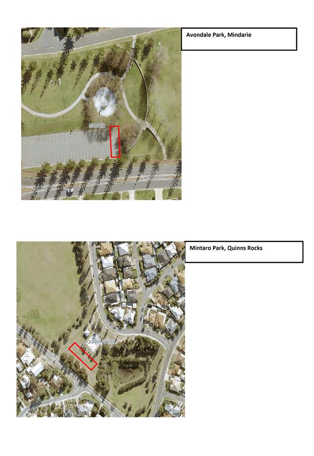
Avondale Park |
Mindarie (North Coastal Ward) |
4 |
|
Mintaro Park |
Quinns Rocks (North Coastal Ward) |
4 |
A map of the proposed trading zones within these sites is included as Attachment 3. Food truck operators would be required to register with the City to participate in the trial, but coordination, promotion and rostering would be their responsibility. They may choose to work on a first-arrival basis or they may choose to organise themselves into a roster for each pre-approved trading zone as is the case in the City of Vincent.
Management Issues
A number of potential issues in relation to the food truck trial have been identified by Administration and a summary of each of these issues is outlined below.
Access to POS
To allow the food trucks to access designated trading zones on the City’s POS they would require a POS key to open the gates. The driving of vehicles on the City’s POS could potentially cause damage to the City’s assets, primarily the sprinkler systems and turf. The final selection of designated trading zones will ensure trading zones are placed to minimise any potential damage.
The trial period of 6 months would offer enough time for Administration to assess how each site coped with the additional vehicle and pedestrian traffic and adjustments could be made throughout the trial period. Future park upgrades to facilitate food truck trading zones may include the removal of turf and installation of suitable hardstand areas to allow for food trucks on POS.
Toilets
Previous trials conducted by other metropolitan councils did not consider provision of toilet facilities when determining trading zones. However, where trading zones are adjacent to existing public toilet facilities the POS key provided to food truck operators would allow them to access these for personal use. It would then be the responsibility of the food truck operators to ensure the building is fully locked when they are finished. It is not considered necessary for the City to provide additional toilet facilities to the general public in addition to what is currently available, as the presence of food trucks is not considered an event.
Additional Waste Service Requirements
The draft Food Truck Guidelines require food truck operators to ensure that all waste produced in the course of their food preparation is maintained inside of their vehicle and removed from site at the end of the trading period. In addition, operators would be required to provide a bin for use by their customers on site, which must also be removed at the end of the trading period. With any increase in POS activation there will be a natural increase in the use of existing bins on site. The impact of food trucks and subsequent activation of the POS on the utilisation of bins within those POS can be monitored throughout the trial period.
Fees
The current fees imposed by the City to obtain a street trading licence are:
· Application Fee (includes on day of trading for temporary licences) $51
· Daily Licence Fee (temporary licences only) $16
· Annual Licence Fee $844
· Weekend and Public Holiday Fee $281
Administration considers it appropriate to pro-rata the annual fees, as the trial would only run initially for 6 months. A review of the fee and possible changes could be investigated at the conclusion of the trial. Administration proposes the food truck trial fee be $422 plus the application fee of $51.
Compliance
Health Services will undertake initial and random onsite inspections to ensure compliance with the health standards required by the Food Act 2008. The onsite inspections will also include checks for compliance with the Food Truck Trial Guidelines including maximum numbers and trading in approved locations. Rangers will also be provided with food truck trading locations to monitor as part of regular patrols, but will not be required to conduct specific inspections. Previous food truck trials conducted in Perth have shown that food truck operators are also willing to self-regulate maximum number compliance to protect the viability of trading zones.
Advertising and Promotion
All advertising and promotion of food truck locations and trading times will be the responsibility of the small business operator for Model One and the operators themselves for Model Two. The City will not be responsible for the primary advertising and promotion of food trucks, however, may at times support the advertising and promotion of food trucks through social media.
Feedback
As part of the permit application, food truck operators will be required to agree to provide written feedback from themselves and their customers on the trial. Feedback will also be sought through the City’s Facebook and website. Any feedback received, either directly from residents or collected by Administration through business as usual activities, will be used in the evaluation of the trail.
Consultation
Community consultation forms part of the trial process, and food truck operators will be required to provide feedback throughout the six month period.
Administration will also advise local residents adjacent to the finalised trading zones and provide feedback options.
Administration briefed Elected Members about the proposed Food Truck Trial at the Council Forum 15 November 2016.
Comment
The draft Food Truck Trial Guidelines have been prepared to address a number of potential issues and promote the positive aspects of allowing food trucks to trade on the City’s POS and in City owned carparks. The proposed trial format and Guidelines have been informed by a number of other metropolitan Council’s successful trials. In the preparation of the Guidelines consultation was undertaken with the City of Vincent and City of Bayswater who both successfully facilitate food truck trading within their Council areas.
The proposed locations have been identified by a desktop analysis only. Conformation of the final sites will require onsite inspections and engagement with local stakeholders such as sporting clubs, to identify exact trading locations and hours as well as best vehicle movement corridors from POS access gates to trading locations.
Work had commenced on facilitating a food truck trial, when Administration was contacted by a small business operator requesting to organise regular food truck trading within the City. There is no one proven model for food truck trading within council areas, therefore Administration considers testing two models could be facilitated during the trial.
If approval to commence the dual-model trial for the summer season the 2016/17 is given, Administration will liaise with the small business operator to set up the Model One in the South Ward and seek expressions of interest from food truck operators to be involved in the general trial, Model Two, in other wards.
Administration intends to monitor the trial on a continuous basis to assess the viability of locations and potential damage to POS. A mid-point review will also consider the possibility of adjusting the number of locations and food truck participants. This may include removing unsuccessful sites from the trial. A conclusion review will include feedback sessions with the food truck operators where they will provide both customer and operator feedback. All feedback and review information collected will be used to prepare a policy if the food truck trial is considered to be successful. If at any point it is considered that the trial is not meeting the objectives or is causing problems that cannot be overcome, the trial may be concluded early at the discretion of the City’s Chief Executive Officer.
Administration has received requests for food truck trading within the City from a number of operators, including the Nollamara RSL, and will work with these individuals and groups to assess if their proposals can be run under the food truck trial or whether they would need to
be considered through the City’s event approval process. Concurrently, Administration is reviewing the current public events approvals process, including what constitutes an event and how to improve existing processes for the City’s customers. Typically Administration considers proposals that provide multiple activities and are likely to impact on surrounding communities, areas, business, parking and roads to be events. To be considered as part of the food truck trial, proposals would need to meet the draft food truck guidelines and criteria.
Statutory Compliance
Pursuant to Clause 61(1)(f) of the Deemed Provision to DPS No.2 a development application would be required for any food trucks to trade in one location for more than 48 accumulative hours in a 12 month period. This provision may be varied by agreement of the local government.
Pursuant to the Food Act 2008 all food businesses operating within the City of Wanneroo are required to register with the City.
Strategic Implications
The proposal aligns with the following objective within the Strategic Community Plan 2013 – 2023:
“2 Society - Healthy, safe, vibrant and active communities.
2.1 Great Places and Quality Lifestyle - People from different cultures find Wanneroo an exciting place to live with quality facilities and services.”
Risk Management Considerations
|
Risk Title |
Risk Rating |
|
Economic Growth |
Moderate |
|
Accountability |
Action Planning Option |
|
Office of the CEO |
Relationships with local Business Associations; Economic Development Strategy and Statutory Planning Changes |
The above risks relating to the issue contained within this report have been identified and considered within the City’s Strategic/Corporate risk register. Action plans have been developed to manage/mitigate/accept this risk to support existing management systems.
Policy Implications
If the food truck trial is considered successful then a Policy may be prepared for Council to consider allowing food trucks to trade on the City’s POS on an ongoing basis.
Financial Implications
There is no budget required to facilitate the food truck trial for the 2016/17 summer period.
There will be some financial implications for the City in relation to the fees for the trial, if a pro-rata fee is applied.
There may also be implications for parks maintenance budgets if damage to POS infrastructure is incurred, although this will be monitored throughout the trial.
Voting Requirements
Absolute Majority
That Council:-
1. SUPPORTS the initiation of a 2016/17 Summer Food Truck Trial between December 2016 and June 2017;
2. APPROVES the Food Truck Trial Guidelines, as per Attachment 1;
3. RESOLVES that no development application is required for any food trucks associated with the 2016/17 Summer Food Truck Trial in accordance with Clause 61(2)(d) of the City of Wanneroo District Planning Scheme No. 2;
4. RESOLVES BY ABSOLUTE MAJORITY to modify fees & charges to pro-rata the Food Truck Trial fee to $422; and
5. AUTHORISES the Chief Executive Officer to make any relevant decision in respect to the Food Truck Trial, relating to:
a) Removal or addition of food truck trading sites;
b) Alteration of food truck trading times; and
c) Early conclusion of the food truck trial.
Attachments:
|
1⇩. |
City of Wanneroo Food Truck Trial Guidelines.DOCX |
16/392023 |
Minuted |
|
2⇩. |
Proposed Trading Zones- Model One |
16/373822 |
|
|
3⇩. |
Proposed Trading Zones - Model Two |
16/373924 |
|
CITY OF WANNEROO Agenda OF Elected Members' Briefing Session 29 November, 2016 78
Approval Services
3.3 Consideration of Development Application for Restaurant and Rural Use at Lot 506 (272) Old Yanchep Road, Carabooda (DA2015/2161)
File Ref: DA2015/2161 – 16/294664
Responsible Officer: Director Planning & Sustainability
Disclosure of Interest: Nil
Attachments: 5
Issue
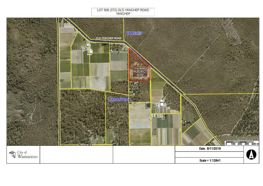
To consider a development application (DA2015/2161) for a Restaurant and Rural Use at 272 Old Yanchep Road, Carabooda (subject site).
|
Applicant |
PPCM |
|
Owner |
Gary Wood and Karla Champion |
|
Location |
Lot 506 (272) Old Yanchep Road, Carabooda |
|
Site Area |
10.2 hectares |
|
DPS 2 Zoning |
Rural Resource |
Background
On 10 June 2015, the City granted planning approval for Intensive Agriculture (Lavender Farm) at the subject site.
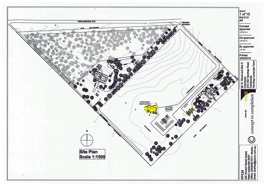
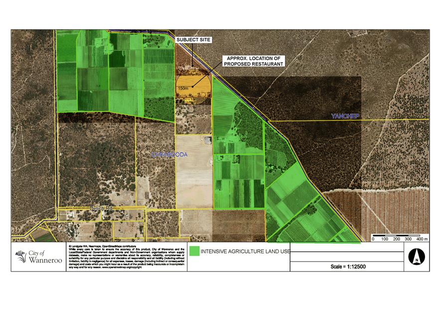
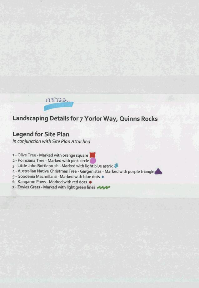
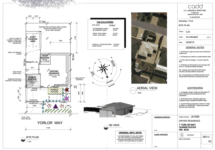
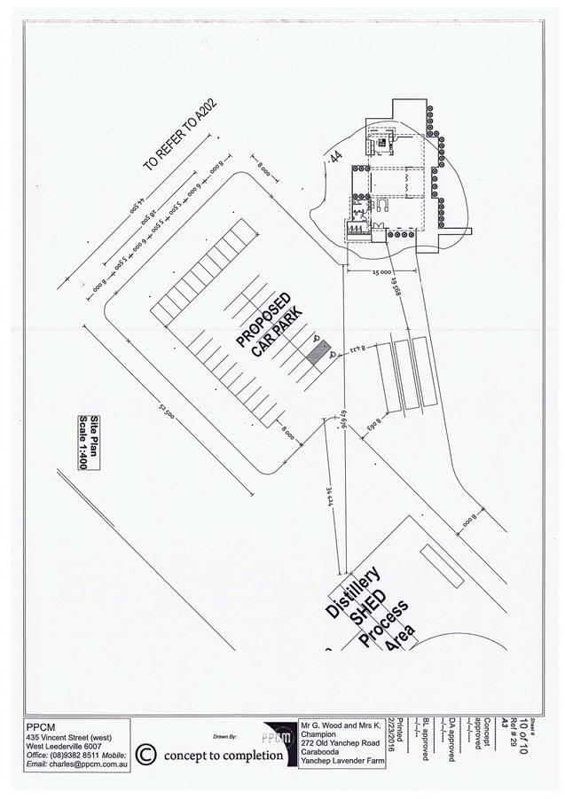
On 23 November 2015, the City received a development application for a Restaurant and Rural Use at the subject site. A location plan of the subject site is included as Attachment 1.
Detail
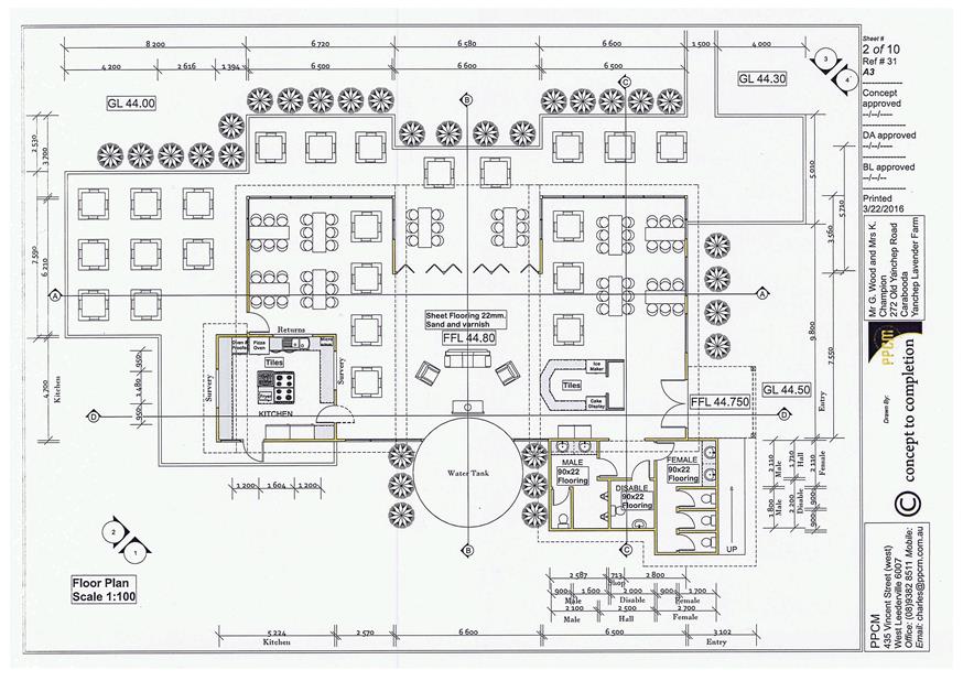
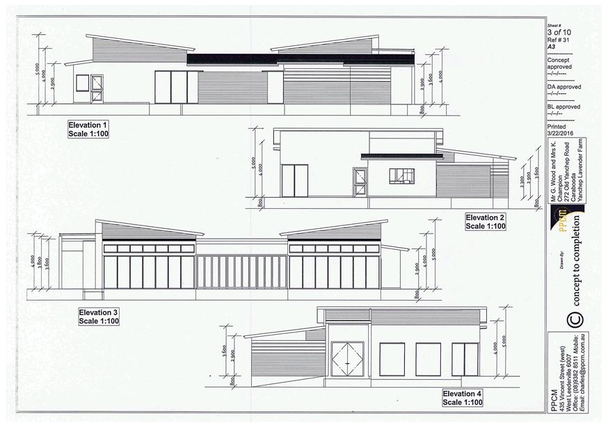
The applicant has proposed a Restaurant and Rural Use which are intended to operate alongside the existing lavender farm on the subject site. The details of the proposal are outlined below:
Restaurant
· Construction of a new building to accommodate a Restaurant, with both indoor and outdoor seating;
· Operating hours: 10.30am – 10.30pm (Monday to Sunday, including Public Holidays);
· Six Restaurant employees;
· 42 onsite car parking bays and three bus parking bays;
· Maximum 50 customers per day (Monday to Wednesday) and 152 customers per day (Thursday to Sunday, including Public Holidays).
Rural Use
· Distilling of lavender products in an existing shed on the subject site, which was approved by the City in 2006;
· Three Rural Use employees;
· Operating hours: 7.00am – 5.00pm (Monday to Sunday, including Public Holidays);
· Selling (by retail) products made from the lavender grown on the farm, such as oils, dried flowers, soaps, creams, potpourri, plants, lavender tea, honey and ice cream. The retail sale of products will take place from a stall within the proposed Restaurant.
As per the City of Wanneroo’s District Planning Scheme No. 2 (DPS 2), a Restaurant is a discretionary (A) use subject to advertising and Rural Use is a permitted (P) use in the Rural Resource zone.
Plans of the proposed Restaurant and the existing shed to be utilised for the distilling of lavender products associated with the Rural Use, are shown in Attachment 2.
Consultation
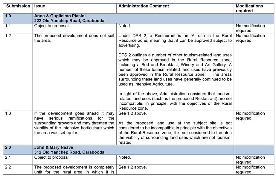
The proposed Restaurant and Rural Use on the subject site were advertised for a period of 14 days in accordance with Clause 64(3) of the Deemed Provisions of DPS 2 by means of written correspondence to surrounding landowners, newspaper notices, a sign on site and a notice on the City’s website. The advertising period commenced 7 June 2016 and closed on 20 June 2016. Four submissions were received during this time, raising objections to the proposed development. The main objections raised by the submitters relate to:
· The incompatibility of the Restaurant use with the surrounding agricultural area; and
· Potential complaints from the owners of the Restaurant, regarding noise and odour from surrounding agricultural land uses, which will threaten the viability of these agricultural land uses.
A summary of the submissions, and Administration’s responses to these, are included as Attachment 3.
Comment
Suitability of the Restaurant and Rural Use within the Rural Resource Zone
Rural Resource Zone
The subject site is zoned Rural Resource under DPS 2. In relation to the Rural Resource zone, Clause 3.17.1 of DPS 2 states the following:
The objectives of the Rural Resource zone are to:
a) Protect from incompatible uses or subdivision, intensive agriculture, horticulture and animal husbandry areas with best prospects for continued expanded use; and
b) Protect from incompatible uses or subdivision basic raw materials priority areas and basic raw materials key extraction areas.
Rural Use
DPS 2 defines Rural Use as:
Agriculture, horticulture and may include aquaculture, and includes the raising of livestock and the retail sale of the produce of the property where satisfactory access and parking can be provided, and provided that any processing of the produce prior to sale can take place on site.
The proposed processing (distilling) of lavender and the sale of lavender products from the subject site are considered to be consistent with the definition of Rural Use. As discussed in the ‘Other Requirements of DPS 2’ section below, the proposed car parking complies with the provisions of DPS 2 and a condition of Planning Approval is recommended to ensure that adequate access is available to the site.
Rural Use is a permitted (P) use in the Rural Resource zone. As such, Administration considers that the proposed Rural Use is consistent with the objectives of the Rural Resource zone.
Restaurant
A Restaurant is a discretionary (A) use subject to advertising in the Rural Resource zone. Besides a Restaurant, Table 1 of DPS 2 outlines a number of other land uses which may be considered tourism-related and which may be approved within the Rural Resource zone. These include a Bed and Breakfast and a Winery, which are discretionary (D) uses, and an Art Gallery and Camping Ground, which are discretionary (A) uses subject to advertising in the Rural Resource zone. As DPS 2 outlines that these land uses may be approved in the Rural Resource area, Administration considers that these tourism-related land uses, including a Restaurant, may in principle be compatible with the objectives of the Rural Resource zone.
The City has previously approved a Restaurant in the Rural Resource zone at 336 Karoborup Road, Carabooda (The Leopard Lodge). Planning Approval was issued for this Restaurant in 2010 and since this time the surrounding area has continued to be used for Intensive Agriculture. Similarly, a number of Wineries, offering retail sale to the public, operate throughout the Rural Resource zone (including two on Carabooda Road, Carabooda).The areas surrounding these Wineries have also continued to be used as Intensive Agriculture. These examples demonstrate that tourism-related land uses, such as Restaurants and Wineries, already operate in the Rural Resource zone and exist alongside other land uses in the area (including Intensive Agriculture). As such, Administration considers that the proposed Restaurant is not, in its nature, an incompatible land use in the Rural Resource zone.
Noise and Odour Regulations
One of the main objections raised during the advertising period related to the potential for the owners of the proposed Restaurant to complain about noise and odour from surrounding agricultural land uses, threatening the viability of these agricultural land uses.
Aerial imagery of the subject site shows that the majority of the surrounding properties, including those belonging to the submitters, have been established as Intensive Agriculture (see Attachment 4). A number of Planning Approvals issued for the surrounding properties confirm that Intensive Agriculture is the predominant land use in the proximity of the subject site. As shown in Attachment 4, the proposed Restaurant is setback a minimum of 150m from the adjoining properties’ Intensive Agriculture growing areas.
The surrounding properties which are currently being used for Intensive Agriculture are required to comply with the relevant legislation relating to noise, odour, dust and pesticide use. This legislation relating to noise, odour, dust and pesticide use applies to the surrounding properties, irrespective of whether the proposed Restaurant is operating from the subject site. The City will be required to investigate any complaints from the landowners of the subject site. If there are no breaches to the relevant legislation, then no action will need to be taken by the City and the viability of the surrounding land uses will not be impacted.
In accordance with Clause 3.17.2(i) of DPS 2, applications for ‘sensitive uses’ (which includes public establishments were food and drink are consumed) within the Rural Resource zone are to be accompanied by a written statement from the landowners, acknowledging the nature and legitimacy of nearby existing and future priority uses (that is, intensive agriculture, horticulture and basic raw materials extraction). This written statement is also required to demonstrate the landowner’s acceptance of the existence, or potential existence, of noise, dust, odour and other impacts which may be associated with priority uses. A written statement to this effect has been provided by the owners of the subject site and is included as Attachment 5.
Further to the above, Clause 3.17.2(k) of DPS 2 requires the landowners to arrange for the inclusion of a notification on the title of the subject site, alerting future landowners of the odours, noise, spray drift and dust which may be associated with the existing and future operation of the priority land uses. A condition of Planning Approval has therefore been recommended to address this requirement.
Contribution to Tourism in the City of Wanneroo
In the City’s Economic Development Strategy 2016 – 2021 (EDS), the continued growth and development of the local tourism industry is identified as one of the means of ensuring economic resilience for the City into the future. In conjunction with the EDS, the Tourism Strategy and Action Plan 2011 – 2017 (TSAP) identifies tourism-specific goals and targets for the City. The vision of the TSAP is to “provide a visitor experience that reflects the unique mix of culture, heritage and environment that makes Wanneroo a top ‘beach to bush’ destination”.
The Restaurant and Rural Use is proposed to operate alongside the existing lavender farm on the subject site, with lavender products (for example soaps and oils) processed on site and available for sale. The applicant has advised that the Restaurant is proposed to be used to showcase and promote the local farming areas in Carabooda and to educate the public on horticulture across the broader Perth area.
The setting of the proposed Restaurant alongside an operational lavender farm provides visitors to the subject site the opportunity to experience an agricultural environment, which is in line with the vision of TSAP. As such, Administration considers that the proposed Restaurant and Rural Use will positively contribute to local tourism within the City.
Access and Egress Considerations for the Subject Site
The applicant has advised that the proposed Restaurant and Rural Use will attract a maximum of 50 – 152 customers per day. The proposal was referred to the City’s Traffic and Transport business unit, who advised that the traffic volumes associated with the proposed development will exceed those of a standard rural property. The City’s Traffic and Transport business unit has advised that the existing crossover to the subject site is required to be upgraded to the specifications detailed in Austroads Guide to Road Design, in order to allow vehicles to safely transition between the low speed driveway on the subject site and Old Yanchep Road which has a speed limit of 110 km/hr. This upgrade involves the construction of short entry and exit crossover wings so that buses and smaller vehicles can safely decelerate to enter the subject site and have adequate sightlines to safely exit the subject site.
The applicant has argued that the existing access to the site already allows for sufficient deceleration of vehicles entering the subject site and sufficient sightlines for vehicles exiting the subject site. As such, the applicant has asserted that no upgrades to the crossover are required as part of this application. The applicant has not provided any advice from professional traffic consultants to support this assertion.
Administration considers that an upgrade to the existing crossover is required to allow for the additional traffic to safely enter and exit the subject site and has therefore recommended that, as a condition of Planning Approval, the crossover for the subject site be upgraded in accordance with Austroads Guide to Road Design.
Bushfire Planning Requirements
The subject site is identified as being located within a bushfire prone area. In accordance with State Planning Policy 3.7 – Planning in Bushfire Prone Areas (SPP 3.7) a development application within a bushfire prone area is to be accompanied by a Bushfire Attack Level (BAL) assessment. The BAL assessment provided with this application identified the site as having a fire rating of BAL – LOW, which is a low fire risk. Therefore, there are no further requirements for the applicant to comply with under SPP 3.7.
Other Requirements of DPS 2
In accordance with DPS 2, the proposed development requires at least 38 car parking bays to be provided onsite. The application includes the provision of 42 onsite car parking bays and 3 onsite bus parking bays to service the proposed development which complies with the provisions of DPS 2. As a condition of Planning Approval, these bays are required to be drained, sealed and marked in accordance with Australian Standard for Offstreet Carparking (AS2890).
The proposed Restaurant also complies with the building setbacks to lot boundaries, as set out in DPS 2 for the Rural Resource zone.
Conclusion
In light of the above, the proposed Restaurant and Rural Use at 272 Old Yanchep Road, Carabooda are considered to be consistent with the objectives of the Rural Resource zone. A number of other tourism-related land uses which receive customers (such as Wineries and a Restaurant) already operate within the Rural Resource zone. These land uses exist alongside land uses which are not tourism-related (such as Intensive Agriculture). As such, the development of the proposed Restaurant is not considered to, by its nature, preclude the operation of other existing or future land uses in the Rural Resource zone (such as Intensive Agriculture).
One of the objections raised by the submitters during advertising related to potential complaints from the owners of the Restaurant, regarding noise and odour from surrounding agricultural land uses, which would threaten the viability of these agricultural land uses. As discussed above, any intensive agriculture activity on the surrounding properties will need to comply with the relevant legislation, irrespective of whether the proposed Restaurant is operating from the subject site. Additionally, the landowners of the subject site have formally acknowledged the nature and legitimacy of the surrounding land uses, and a notification on the title of the subject site will be required as a condition of Planning Approval to this effect.
Administration considers that the nature of the proposed Restaurant and Rural Use at the subject site will positively contribute to tourism within the City of Wanneroo.
Administration considers that the issues raised in the letters of objection have been addressed and no modifications to the proposal are required in light of those objections. It is therefore recommended that Council approve the proposed Restaurant and Rural Use at Lot 506 (272) Old Yanchep Road, Carabooda, subject to the conditions outlined below.
Statutory Compliance
This application has been assessed in accordance with the City of Wanneroo’s District Planning Scheme No. 2.
Delegation to Determine Application
Pursuant to Part 8.3(b) of the City’s Delegated Authority Register, the application may be considered under delegation if, it is the view of the Director, Planning and Sustainability, that the objections do not raise relevant planning considerations that cannot be specifically addressed or overcome by modifications to the proposal, or imposition of appropriate conditions of approval.
In this instance, Administration is of the opinion that the objections raise relevant planning considerations in relation to the suitability of the proposed Restaurant in the Rural Resource zone. Therefore, the application cannot be considered under delegated authority and must be determined by Council.
Strategic Implications
The proposal aligns with the following objective within the Strategic Community Plan 2013 – 2023:
“3 Economy - Progressive, connected communities that enable economic growth and employment.
3.2 Growing Business - Our community is a preferred place for business to locate and grow.”
Risk Management Considerations
|
Risk Title |
Risk Rating |
|
ST-S12 Economic Growth |
Moderate |
|
Accountability |
Action Planning Option |
|
Director Planning and Sustainability |
Manage |
The above risk relating to the issue contained within this report has been identified and considered within the City’s Strategic risk register. Action plans have been developed to manage this risk to support and improve the existing management systems.
Policy Implications
Nil
Financial Implications
Nil
Voting Requirements
Simple Majority
That Council pursuant to Clause 68(2)(b) of the Deemed Provisions of the District Planning Scheme No. 2, APPROVES the Development Application (DA2015/2161) as shown in Attachment 2 for the Restaurant and Rural Use at Lot 506 (272) Old Yanchep Road, Carabooda, subject to the following conditions:
1. This approval only relates to the proposed Restaurant and Rural Use, as shown on Attachment 2. It does not relate to any other development on the site.
2. The use of the approved premises shall conform to the City of Wanneroo’s District Planning Scheme No. 2 definitions of Restaurant and Rural Use, which are:
Restaurant: means any premises where the predominant use is the preparation of food for sale and consumption within the building or portion thereof. The expression may include the sale of food for consumption off the premises, where Council is of the opinion that it is incidental to the business. The term may include an outdoor eating area which shall be treated as being within the building of the Restaurant. The expression excludes Drive Through Food Outlets.
Rural Use: Means agriculture, horticulture and may include aquaculture, and includes the raising of livestock and the retail sale of the produce of the property where satisfactory access and parking can be provide, and provided that any processing of the produce prior to sale can take place on site.
3. Stormwater and any other water run-off from buildings or paved areas shall be collected and contained on site.
4. The Restaurant shall be limited to a maximum of 152 customers at any one time.
5. The operating hours of the Restaurant shall be limited to between 10.30am – 10.30pm, Monday to Sunday and on Public Holidays.
6. The operating hours of the Rural Use shall be limited to between 7.00am – 5.00pm, Monday to Sunday and on Public Holidays.
7. The existing vehicle crossover to the subject site shall be modified and constructed to the rural specifications detailed in Austroads Guide to Road Design, prior to the occupation of the development.
8. Parking areas shall be designed and constructed in accordance with the Australian Standard for Offstreet Carparking (AS2890), and shall be drained, sealed and marked.
9. A notification under Section 70A of the Transfer of Land Act 1893 is to be prepared in a form acceptable to the City and lodged with the Registrar of Titles for endorsement on the Certificate of Title for the subject site, prior to the commencement of works associated with the Restaurant and Rural Use. The notification is to state as follows:
“This lot is located in the Rural Resource zone, where the priority land uses are intensive agriculture, horticulture and basic raw materials extraction. This lot may be affected by odours, noise, spray drift and dust associated with the existing and future operation of these land uses.”
Attachments:
|
1⇩. |
DA2015/2161 - Location Plan - 272 Old Yanchep Road, Carabooda |
16/380649 |
|
|
2⇩. |
DA2015/2161 - Plans and Elevations - 272 Old Yanchep Road, Carabooda |
16/398708 |
Minuted |
|
3⇩. |
DA2015/2161 - Summary of Submissions - 272 Old Yanchep Road, Carabooda |
16/388466 |
|
|
4⇩. |
DA2015/2161 - Map of Adjoining Properties - 272 Old Yanchep Road, Carabooda |
16/317594 |
|
|
5⇩. |
DA2015/2161 - Written Statement from Landowners Ackowledging Nature and Legitimacy of Surrounding Land Uses - 272 Old Yanchep Road, Carabooda |
16/391639 |
|
CITY OF WANNEROO Agenda OF Elected Members' Briefing Session 29 November, 2016 95
3.4 Development Application - Commercial Vehicle Parking and Sea Containers (Retrospective) - Lot 158 (44) Bebich Drive, Wanneroo (DA2016/1227)
File Ref: DA2016/1227 – 16/347325
Responsible Officer: Director Planning & Sustainability
Disclosure of Interest: Nil
Attachments: 5
Issue
To consider an application for retrospective development approval for commercial vehicle parking and sea containers at Lot 158 (44) Bebich Drive, Wanneroo.
|
Applicant |
Giuseppi La Rosa |
|
Owner |
Giuseppi La Rosa & Rosina Concetta La Rosa |
|
Location |
Lot 158 (44) Bebich Drive, Wanneroo |
|
Site Area |
1.0086 hectares |
|
DPS 2 Zoning |
Special Rural (07) |
Background
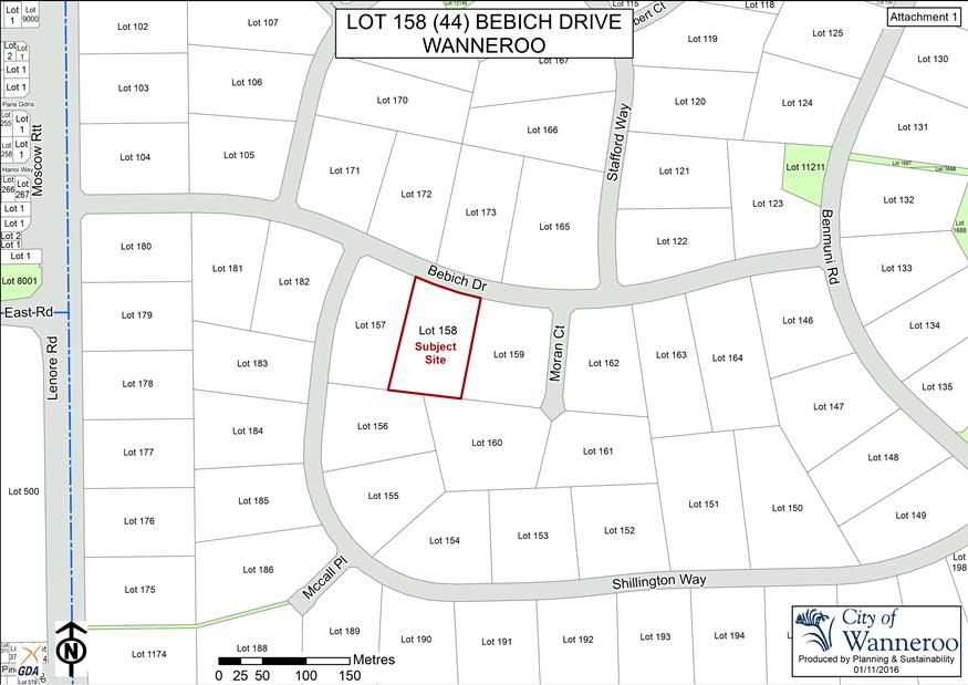
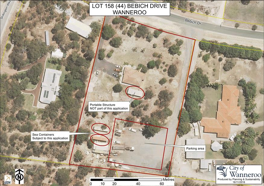
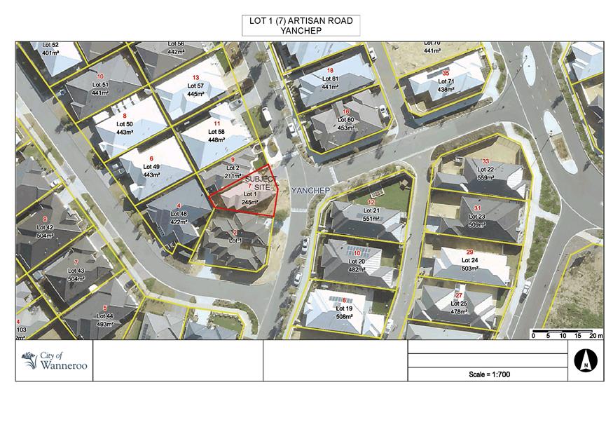
Lot 158 (44) Bebich Drive, Wanneroo (subject property) is situated where indicated on the plan included as Attachment 1. The subject property is zoned Special Rural under the City’s District Planning Scheme No. 2 (DPS 2).
The subject property currently contains the following features:
· A brick and tile residence;
· A shed, situated in proximity to the southwestern corner of the subject site;
· Two sea containers, situated in proximity to the shed as described above;
· A hardstand area (constructed with crushed limestone and rock) at the rear of the property. The hardstand area is used for the parking of various commercial vehicles. This hardstand area is connected to Bebich Drive by a driveway constructed in the same material, situated adjoining the eastern side of the subject property; and
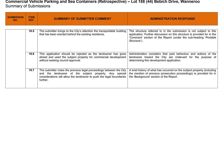
· A portable structure, located immediately behind the brick and tile residence (as viewed from Bebich Drive).
The parking of commercial vehicles is an unauthorised use of the subject property, which Administration has attempted to bring into compliance since 2004. Although the City has undertaken extensive compliance actions against the landowners (including successfully prosecuting the landowner for non-compliance through the Magistrates Court, for which the landowner was fined), the parking of commercial vehicles is still being carried out on the subject property.
Up until the lodgement of this application for retrospective development approval, Administration was pursuing compliance actions against the applicant. However, as this application has been lodged by the applicant in an attempt to being the 5property into compliance, further compliance actions are currently not being pursued pending the outcome of this application. If the subject property remains non-compliant following the determination of this application, Administration will pursue further compliance actions accordingly.
Detail
On 2 September 2016, Administration received an application for retrospective development approval for the following:
· The parking of 15 commercial vehicles (five trucks, five dollies and five trailers) on the property; and
· Two sea containers located in the vicinity of the southwestern corner of the property.
The plan lodged by the applicant in respect to this application is included as Attachment 2. Administration has provided Attachment 3 to better highlight the locations of the commercial vehicle parking area and the sea containers subject to the application, in respect to other development and features on the subject property.
Consultation
Public consultation was undertaken for a period of 21 days from 15 September 2016 to 6 October 2016 by way of letters to landowners and occupiers of eight land parcels adjoining and opposite the subject property.
The letter invited landowners/occupiers to comment on the application for retrospective development approval before the City.
The landowners/occupiers of 9 Shillington Way, Wanneroo were also invited to comment on the setback of the sea containers to their common side boundary with the applicant. Comment was sought as the current setback of the sea containers is less than 15 metres from the boundary, which is the minimum side boundary setback requirement under DPS 2. Although this adjoining landowner did not provide a comment to the City in respect to the setback of the sea containers, the applicant has provided Administration a comment of ‘no-objection’ for the setback that they obtained from this landowner.
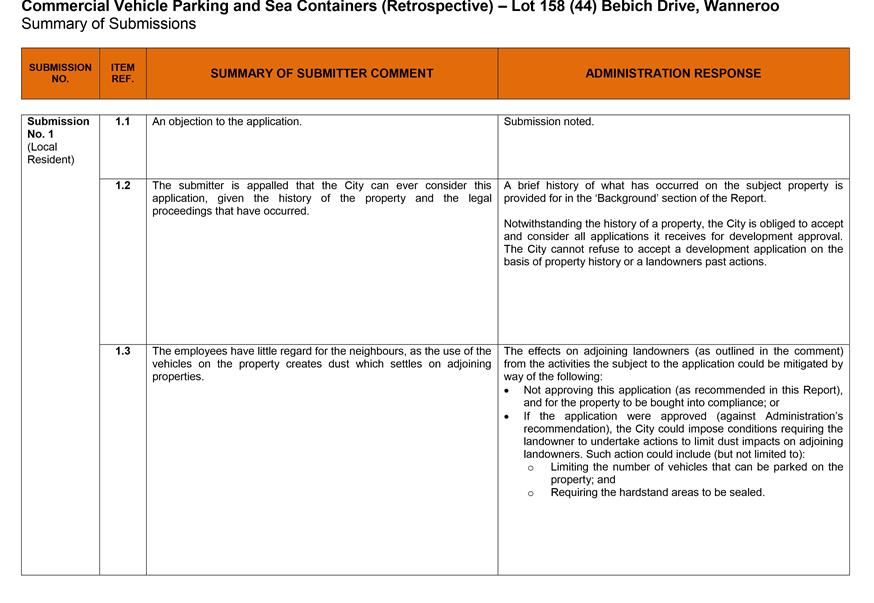
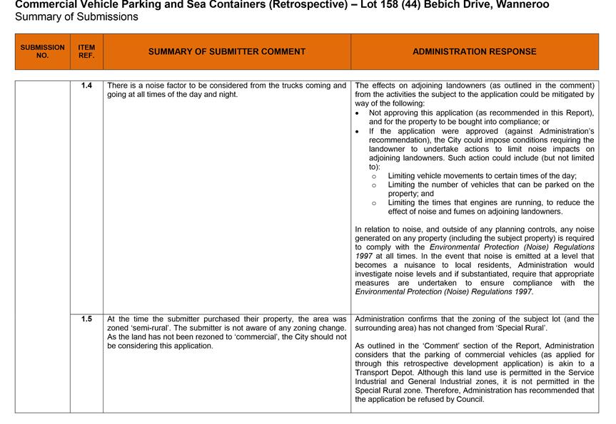
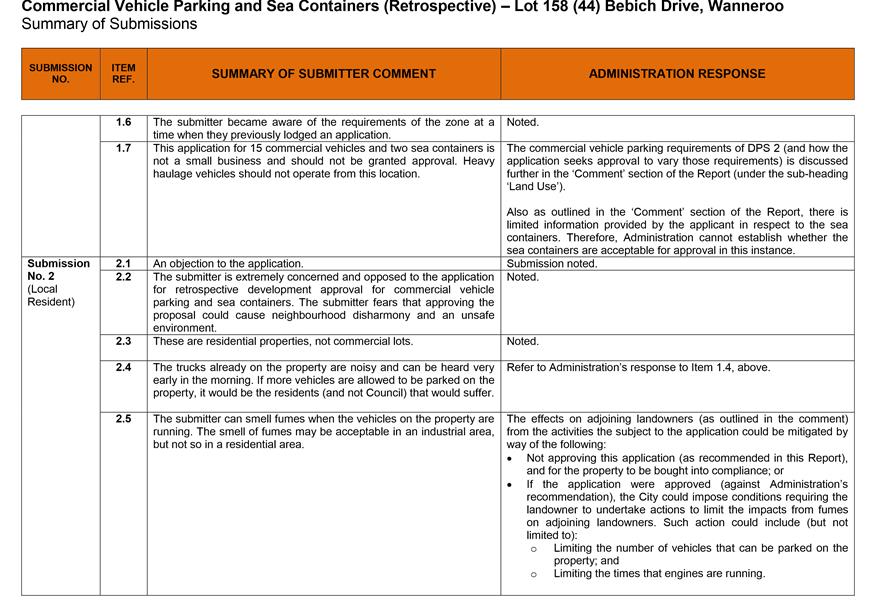
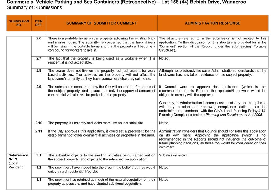
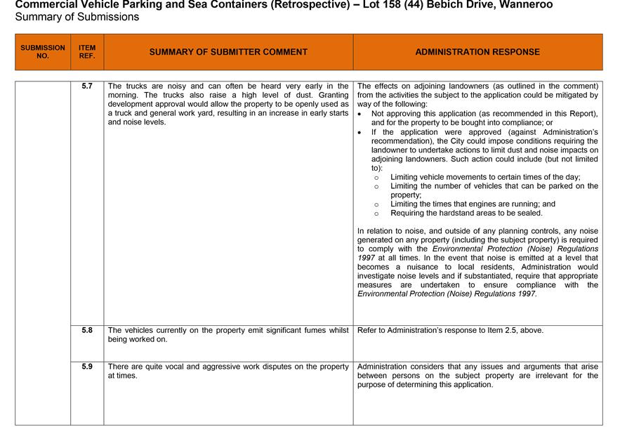
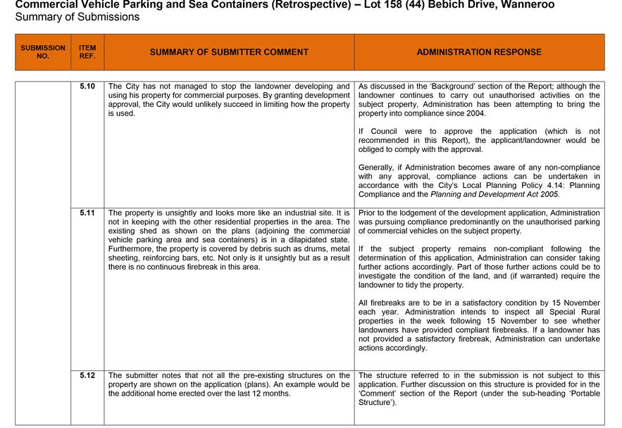
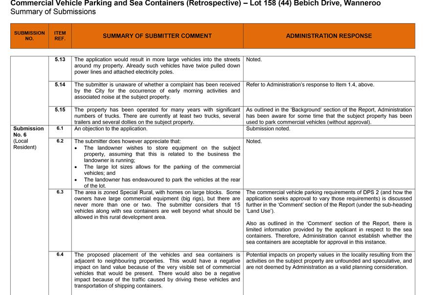
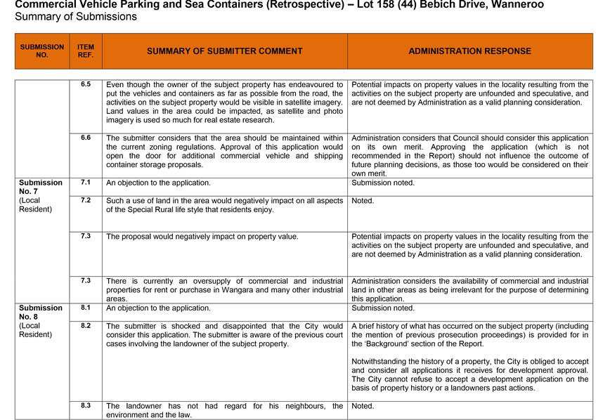
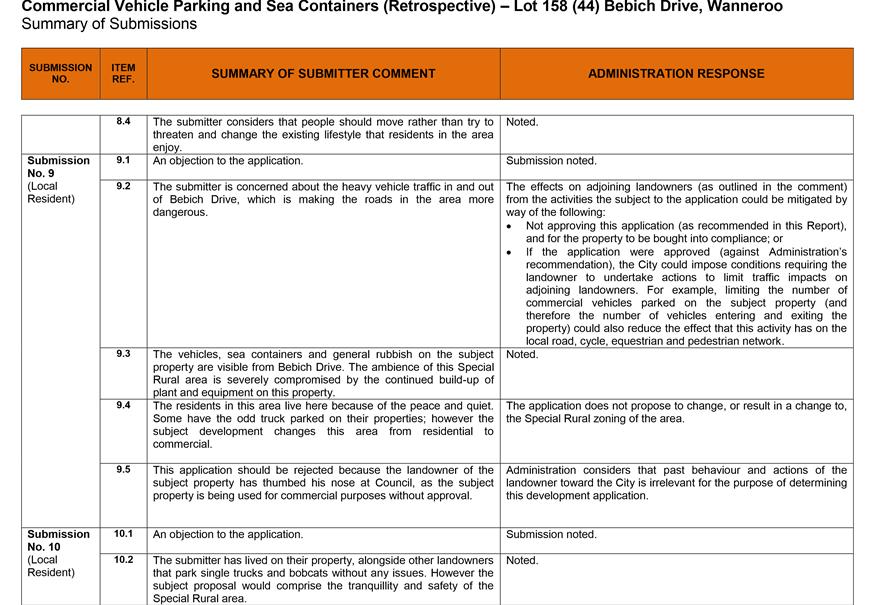
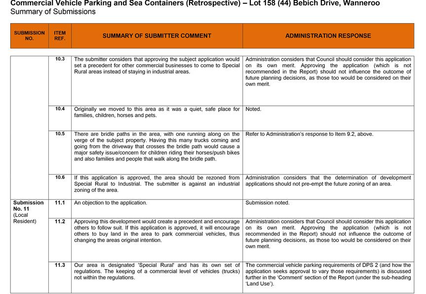
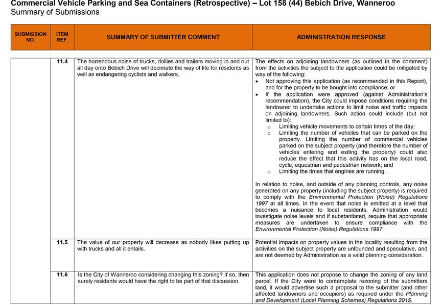
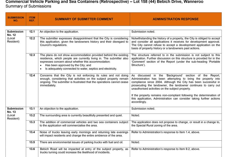
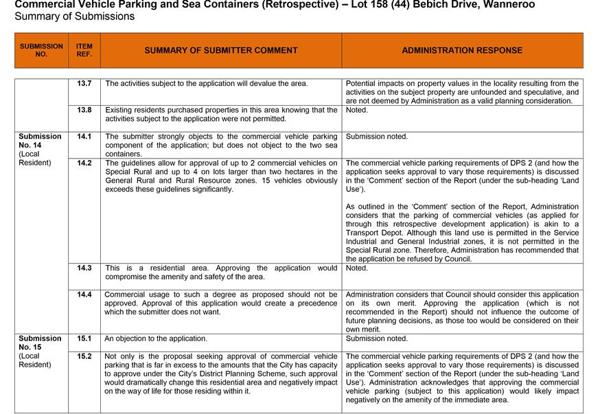
At the conclusion of the comment period, 18 submissions were received. Of the 18 submissions received, 17 expressed an objection to the application generally. One submission expressed a ‘no objection’ in respect to the sea containers; however, the same submission objected to the commercial vehicle parking. Of the submissions received, ten were from landowners/occupiers of properties that Administration did not forward a letter to.
A summary of submissions received and Administration’s responses are shown in Attachment 4. The main issues raised during the advertising period and following detailed assessment by Administration relate to:
· Potential conflicts with the objectives and requirements of the Special Rural zone; and
· The presence of a portable structure on the property, which is not indicated on the applicant’s submitted plans.
A more detailed discussion of the major issues considered in the assessment of the application is provided in the Comment section below.
Comment
In assessing the proposal, Administration has identified the following key aspects as discussed below.
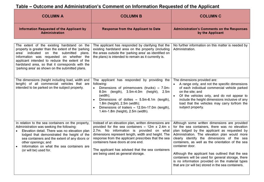
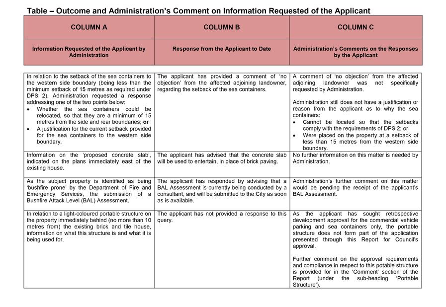
Information Requested from the Applicant
Administration undertook a preliminary assessment of the application; and in letters dated 20 September 2016 and 10 October 2016, requested the applicant to provide the City with information. Attachment 5 outlines the following:
· The information requested of the applicant by Administration;
· Responses from the applicant to date; and
· Administration’s comments on the responses by the applicant.
As outlined in Attachment 5, the applicant has not provided Administration with all the information that it initially requested. The information Administration requested was primarily intended to:
· Better inform Administration and Elected Members with more detail relating to the commercial vehicle parking subject to the application;
· Better understand the scale and use of the sea containers subject to the application – and understand why the sea containers have been placed where they are; and
· Clarify the portable structure that was identified in the submissions, but not identified on the plans provided by the applicant.
Under Clause 75 of the DPS 2 Deemed Provisions, the City must determine an advertised application within 90 days of its receipt. As the application was lodged on 2 September 2016, 90 days elapsed on 1 December 2016. Given that the 90 day time period has elapsed, Administration considers that the application can be considered by Council for determination – even if all of the information requested has not been provided.
Land Use
Clause 4.23 of DPS 2 states that Council may permit (subject to approval) up to two commercial vehicles to be parked on a lot zoned Special Rural. Although Administration did not receive all the details that it was seeking from the applicant regarding the commercial vehicle parking; Administration can still confirm that the applicant is applying for retrospective development approval to park more than two commercial vehicles on the subject property.
The application provides sufficient information for Administration to conclude that the parking of commercial vehicles (as applied for through this application for retrospective development approval) is akin to a ‘Transport Depot’ as defined in DPS 2 as follows:
“transport depot : means any land or building designed and used, or which is adapted for use for one or more of the following purposes:
a) for the parking or garaging of more than one commercial vehicle;
b) for the transfer of goods or passengers from one vehicle to another vehicle;
and may include the maintenance, mechanical repair or refuelling of the vehicles referred to in (a) or (b) above but does not include any of the functions defined under Smash Repair Station.”
The Transport Depot use class is permitted (or a ‘P’ use) in the Service Industrial and the General Industrial zone. This use class is not permitted (or an ‘X’ use) in the Special Rural zone.
Objectives of the Special Rural Zone
The submissions received argued that the application seeks approval for activities that are contrary to the objectives of the Special Rural zone, as prescribed in DPS 2. DPS 2 contains a Statement of Intent (in subclause 3.18.1) and objectives (in subclause 3.18.2) for the
Special Rural Zone. The Statement of Intent and objectives for the Special Rural zone are as follows:
3.18.1 The Special Rural Zone is intended to accommodate rural-residential retreats on lots generally ranging between one and four hectares in size. In some cases, agricultural uses are also intended to be accommodated. All development in the Special Rural Zone shall be conducted in a manner that preserves local amenity and the natural landscape or rural character of the zone concerned.
3.18.2 The objectives of the Special Rural Zone are to:
a) designate areas where rural-residential retreats can be accommodated without detriment to the environment or the rural character;
b) meet the demand for a rural lifestyle on small rural lots generally ranging from one to four hectares in size;
c) maintain and enhance the rural character and amenity of the locality.
Administration considers that the commercial vehicle parking subject to the development application as being in conflict with the Statement of Intent and objectives for the Special Rural zone as outlined above. Given the scale of the commercial vehicle parking subject to the application, Administration considers that the commercial vehicle parking poses an unacceptable detriment to the environment, rural character and local amenity of the area.
Given the limited information provided by the applicant in respect to the sea containers, Administration cannot establish whether the sea containers are in conflict with the Statement of Intent and objectives for the Special Rural zone. To date, the applicant has:
· Not provided an elevation plan for the sea containers; and
· Provided information that the sea containers will be used for general storage – however has not provided information on what materials will be stored in these structures.
DPS 2 Special Provisions
DPS 2 provides for 18 Special Rural areas, and provides Special Provisions for each. The subject property is situated in an area that DPS 2 defines as Special Rural Zone (07). Relevant to the assessment of this application, Special Provision (2) prescribed for Special Rural Zone (07) is as follows:
(2) The land the subject of this Zone may be used for residential and equestrian purposes only.
On review of the application – and noting that the subject property does not appear to be used for any equestrian purpose – Administration considers that:
· Without having adequate detail as to what is being stored in the sea containers, it cannot be established whether the sea containers will be used in conjunction with residential purposes; and
· Given the scale of the commercial vehicle parking subject to the application, the use of the land for parking of the commercial vehicles (as applied for in the application for retrospective development approval) is not considered to be ‘residential’ in nature.
Comparisons with Approval Granted for Commercial Vehicle Parking on Nearby Lot
The applicant in their application submission (and subsequent correspondence to Administration) identified a previous development approval; granted by Council at its 30 April 2013 Meeting (CR03-04/13) for the landowners of Lot 103 (193) Lenore Road, Wanneroo to park five commercial vehicles on their property (DA2012/453). Lot 103 is zoned Special Rural (07), as is the property subject to this Report. The applicant has requested that the City exercise discretion on its DPS 2 requirements and approve the parking of more than two commercial vehicles on the subject property, as the City did when it considered the previous application for Lot 103 Lenore Road.
Administration has outlined below some key differences between the approval issued for commercial vehicle parking at Lot 103 Lenore Road, and what the application subject to this Report is seeking approval for:
· The approval issued for DA2012/453 was to park three trucks and two trailers on the property subject to that approval (five commercial vehicles in total). The application subject to this Report is to park five trucks, five dollies and five trailers (15 commercial vehicles in total).
· The approval issued for DA2012/453 required the commercial vehicles to be parked in an undercover area. That approval also required a colorbond screen to be installed on the eastern side of the parking area, to reduce the visibility of the commercial vehicles from affected adjoining landowners. The application subject to this Report seeks approval to park trucks on a hardstand area that is not covered or screened by colorbond sheeting.
· The approval issued for DA2012/453 required the commercial vehicles to be screened by way of vegetation planted adjoining the side boundaries. With regard to the application subject to this Report, Administration sought information from the applicant to provide detail of any vegetation screening that they would provide. As outlined in Attachment 5, the response received from the applicant is limited, and does not provide any commitment that vegetation to screen the commercial vehicles will be installed should the application be approved.
Portable Structure
The submissions received identified a portable structure on the subject property, situated behind the brick and tile dwelling. The location of this structure is identified on the aerial image enclosed in Attachment 3. The submitters have noted that this structure was not on the applicant’s plan, which was available for viewing during the public consultation period (refer Attachment 2). The submitters are also alleging that there are occupants residing in this structure.
As outlined in Attachment 5, Administration requested more information from the applicant about this structure (and its use); however the applicant is yet to provide information on this matter. Therefore, it remains unclear what the portable structure is or what it is used for.
As the applicant has sought the retrospective development approval for the commercial vehicle parking and sea containers only, the portable structure does not form part of the application presented through this Report for Council’s approval.
On review of the City’s records, Administration does not consider that this portable structure has the necessary approvals of the City. Administration considers that this structure requires the relevant building and planning approvals. Although Administration can pursue compliance action against the landowner for this structure, this can occur separately to the consideration and determination of the current development application.
Similarly, Administration does not consider that any non-compliance of the portable structure should influence the outcome of this application.
Conclusion
Administration acknowledges that more information from the applicant for the commercial vehicles would have been beneficial for it to better report on this aspect of the application. However with the information available, Administration can still gain a sufficient understanding that the commercial vehicle parking on the subject property as applied for in this application is:
· Akin to a Transport Depot, as it is defined in DPS 2. As outlined above, the Transport Depot use class is a prohibited (or ‘X’) use in the Special Rural zone; and
· Non-compliant with the Special Provisions relating to Special Rural Zone (07), as prescribed in Schedule 10 of DPS 2.
As outlined in Attachment 5, more information from the applicant on the sea containers (such as elevation plans and detail on what materials will be stored in the sea containers) was requested. The information that Administration did receive in respect to the sea containers was insufficient for it to recommend a favourable determination concerning this development.
In light of the above, Administration is recommending that Council refuse to grant approval of the application for retrospective development approval.
In respect to any non-compliance on the subject property following Council’s determination of this application; Administration can commence further compliance proceedings against the landowners pursuant to the City’s Local Planning Policy 4.14: Planning Compliance. Further compliance proceedings would occur separately from the prosecution proceedings that have already occurred against the landowner, as discussed in the ‘Background’ section of the Report.
Statutory Compliance
This application has been assessed in accordance with the City of Wanneroo’s District Planning Scheme No. 2.
Strategic Implications
The proposal aligns with the following objective within the Strategic Community Plan 2013 – 2023:
“4 Civic Leadership - Working with others to ensure the best use of our resources.
4.2 Working With Others - The community is a desirable place to live and work as the City works with others to deliver the most appropriate outcomes.”
Risk Management Considerations
There are no existing Strategic or Corporate risks within the City's existing risk registers which relate to the issues contained in this report.
Policy Implications
Nil
Financial Implications
Should compliance proceedings against the landowner recommence following Council’s decision on this development application, costs in undertaking such further proceedings would be dependent on the landowner’s further actions arising there from.
Voting Requirements
Simple Majority
That Council:-
1. Pursuant to Clause 68(2)(c) of the Deemed Provisions of District Planning Scheme No. 2, REFUSES to grant approval of the application for retrospective development approval for commercial vehicle parking and sea containers at Lot 158 (44) Bebich Drive, Wanneroo as shown in Attachment 2, for the following reasons:
a) The parking of commercial vehicles on the subject property (as applied for through this application for retrospective development approval) is considered by the City to be a ‘Transport Depot’, as defined in District Planning Scheme No. 2 as follows:
transport depot : means any land or building designed and used, or which is adapted for use for one or more of the following purposes:
a) for the parking or garaging of more than one commercial vehicle;
b) for the transfer of goods or passengers from one vehicle to another vehicle;
and may include the maintenance, mechanical repair or refuelling of the vehicles referred to in (a) or (b) above but does not include any of the functions defined under Smash Repair Station.
Under District Planning Scheme No. 2, a Transport Depot is not permitted (or an ‘X’ use) in the Special Rural zone.
b) The parking of commercial vehicles on the subject property (as applied for through this application for retrospective development approval) is contrary to Special Provision (2) for Special Rural Zone (07); as outlined in Schedule 10 of District Planning Scheme No. 2 and as follows:
(2) The land the subject of this Zone may be used for residential and equestrian purposes only.
c) Insufficient information was provided for the sea containers subject to this application for retrospective development approval to allow for the appropriate assessment and ultimately any favourable determination concerning this development.
2. ENDORSES Administration’s responses to the submissions as provided for in Attachment 4;
3. NOTES that Administration will now, pursuant to the City’s Local Planning Policy 4.14: Planning Compliance, recommence actions against the landowner of Lot 158 (44) Bebich Drive, Wanneroo, necessary to bring this property into compliance with District Planning Scheme No. 2; and
4. ADVISES the submitters and the applicant of this decision.
Attachments:
|
1⇩. |
Attachment 1 - Council Report - Lot 158 (44) Bebich Drive |
16/374072 |
|
|
2⇩. |
Plans Submitted for DA - Commercial Vehicle Parking and Sea Containers (Retrospective) - DA2016/1227 - Lot 158 (44) Bebich Drive Wanneroo |
16/324233 |
Minuted |
|
3⇩. |
Attachment 3 - Images to Show Property Features and Items subject to DA |
16/389604 |
|
|
4⇩. |
Attachment 4 - Summary of Submissions - Retrospective DA for Commercial Vehicle Parking and Sea Containers - Lot 158 (44) Bebich Drive, Wanneroo |
16/399238 |
Minuted |
|
5⇩. |
Attachment 5 - Outcome and Administration's Comment on Information Requested of the Applicant |
16/399826 |
|
CITY OF WANNEROO Agenda OF Elected Members' Briefing Session 29 November, 2016 129
3.5 Consideration of Development Application for Single House Addition (Patio) at Lot 1 (7) Artisan Road, Yanchep
File Ref: DA2016/885 – 16/350167
Responsible Officer: Director Planning & Sustainability
Disclosure of Interest: Nil
Attachments: 3
Issue
To consider a development application (DA2016/885) for a Single House Addition (Patio) at 7 Artisan Road, Yanchep (subject site).
|
Applicant |
Green Army Services Building and Maintenance |
|
Owner |
Mr Matthew Gray |
|
Location |
Lot 1 (7) Artisan Road, Yanchep |
|
Site Area |
245m2 |
|
DPS 2 Zoning |
Urban Development |
|
ASP 68 Zoning |
Residential R40 |
Background
On 1 July 2016 the City received a development application for a Single House Addition (Patio) at the subject site. A location plan of the subject site in included in Attachment 1.
Detail
The site plan, floor plan and elevation for the proposal are included in Attachment 2. The proposed patio is approximately 15.5m2 in area with a maximum height of 2.8m.
The proposed patio is setback 0.5m from the northern, western and southern lot boundaries. The proposed lot boundary setbacks of the proposed patio are variations to the ‘deemed-to-comply’ provisions of Clause 5.1.3 of the Residential Design Codes (R-Codes) which requires a minimum setback of 1.0m from each lot boundary.
Consultation
Advertising of the proposal was undertaken by the City in writing to the affected landowners adjoining the northern, western and southern lot boundaries (9 Artisan Road, 4 Gallery Way and 5 Artisan Road, Yanchep, respectively). Advertising was undertaken for a period of 14 days commencing 8 August 2016 and closing 22 August 2016. A submission objecting to the proposal was received from the western adjoining landowner (4 Gallery Way, Yanchep). The adjoining landowner raised concerns with the potential negative effects of the proposed patio on their property, including overshadowing and building bulk. A summary of the submission in included as Attachment 3.
Comment
Assessment of Application
In accordance with Part 2 of the R-Codes, if a proposal does not meet the 'deemed-to-comply' provisions, the City is to exercise its judgement to consider the merits of the proposal having regard to the relevant 'design principles'.
As the proposed patio does not meet the 'deemed-to-comply' requirements of Clause 5.1.3 of the R-Codes in regards to lot boundary setbacks, it has been assessed against the corresponding 'design principles', as detailed in the table below.
|
Design Principles – Clause 5.1.3 P3.1 |
Administration Comments |
|
Reduce impacts of building bulk on adjoining properties. |
The proposed patio is unenclosed on the northern, western and southern sides. Generally, building bulk arises from large solid walls and structures that impact the amenity of the adjoining properties. The unenclosed design of the patio ensures that the impact of building bulk resulting from the portion of the patio which is visible above the boundary fence is reduced. |
|
Provide adequate direct sun and ventilation to the building and open space on the site and adjoining properties. |
With the addition of the proposed patio, the development on the subject site (including the existing dwelling) will result in 1% total overshadowing of the western property’s site area and 11% total overshadowing of the southern property’s site area. This is less than the maximum overshadowing of 50% which is permitted under the ‘deemed-to-comply’ provisions of Clause 5.4.2 of the R-Codes.
In regards to the ventilation to the buildings and open spaces on the subject lot and adjoining property, the patio is an unenclosed structure and therefore will not restrict ventilation. |
|
Minimise the extent of overlooking and resultant loss of privacy on adjoining properties. |
The finished floor level of the patio is proposed to be the same as the existing ground level. Therefore, the proposed patio will not result in overlooking to the adjoining property. The privacy of the adjoining property will be maintained by the existing boundary fence. |
In light of the above, the proposed setback variations for the patio are considered to meet the relevant ‘design principles’ of the R-Codes. The patio also satisfies all other requirements of the R-Codes. Administration considers that the issues raised in the letter of objection have been addressed and no modification to the proposal is required. It is therefore recommended that Council approve the proposed patio at Lot 1 (7) Artisan Road, Yanchep.
Statutory Compliance
Delegation to Determine Application
Pursuant to Part 8.3(b) of the City’s Delegated Authority Register, the application may be considered under delegation if, it is the view of the Director, Planning and Sustainability, that the objections do not raise relevant planning considerations that cannot be specifically addressed or overcome by modifications to the proposal, or imposition of appropriate conditions of approval.
In this instance, Administration is of the opinion that the objection raises relevant planning considerations in relation to potential overshadowing and building bulk of the patio for the adjoining property. Therefore, the application cannot be considered under delegated authority and must be determined by Council.
Strategic Implications
The proposal aligns with the following objective within the Strategic Community Plan 2013 – 2023:
“2 Society - Healthy, safe, vibrant and active communities.
2.1 Great Places and Quality Lifestyle - People from different cultures find Wanneroo an exciting place to live with quality facilities and services.”
Risk Management Considerations
There are no existing Strategic or Corporate risks within the City's existing risk registers which relate to the issues contained in this report.
Policy Implications
This application has been assessed against the provisions of the Residential Design Codes.
Financial Implications
Nil
Voting Requirements
Simple Majority
That Council pursuant to Clause 68(2)(b) of the Deemed Provisions of the District Planning Scheme No. 2, APPROVES the Development Application (DA2016/885) as shown in Attachment 2 for the Single House Addition (Patio) at Lot 1 (7) Artisan Road, Yanchep, subject to the following conditions:
1. This approval only relates to the Single House Addition (Patio), as highlighted on Attachment 2. It does not relate to any other development on the site; and
2. Stormwater and any other water run-off from buildings or paved areas shall be collected and contained on site.
Attachments:
|
1⇩. |
Attachment 1 - Location Plan - 7 Artisan Road, Yanchep |
16/379490 |
|
|
2⇩. |
Attachment 2 - Site Plan and Elevations - 7 Artisan Road, Yanchep |
16/350338 |
Minuted |
|
3⇩. |
Attachment 3 - Summary of Submission - 7 Artisan Road, Yanchep |
16/350562 |
|
CITY OF WANNEROO Agenda OF Elected Members' Briefing Session 29 November, 2016 136
3.6 Consideration of Development Application for Single House (Amendment to DA2016/686) at 6 Bogdanich Way, Madeley
File Ref: DA2016/1224 – 16/351719
Responsible Officer: Director Planning & Sustainability
Disclosure of Interest: Nil
Attachments: 3
Issue
To consider a development application for a Single House (Amendment to DA2016/686) at 6 Bogdanich Way, Madeley (subject site).
|
Applicant |
Domination Homes |
|
Owner |
Vincent De Marte, Nicole De Marte and Michael De Marte |
|
Location |
Lot 287 (6) Bogdanich Way, Madeley |
|
Site Area |
554m2 |
|
DPS 2 Zoning |
Urban Development |
|
ASP 8 Zoning |
Residential R20 |
Background
On 20 June 2016, the City approved a Single House at the subject site (DA2016/686). A location plan of the subject site is included as Attachment 1. As part of DA2016/686, approval was also issued for an enclosed cabana at the rear of the subject site.
The cabana was approved with an area of 10.73m2 and a maximum height of 2.75m. The cabana was approved with walls built up to the side and rear boundaries. The side boundary wall was 2.99m in length and the rear boundary wall was 3.59m in length.
For a lot with a density coding of R20, the Residential Design Codes (R-Codes) permit a boundary wall to one lot boundary only. As such, the two boundary walls proposed for the cabana under DA2016/686 constituted a variation to the deemed-to-comply provisions of the R-Codes. Under DA2016/686, the boundary wall variation was advertised to the landowner adjoining the rear lot boundary. The adjoining landowner advised that they did not object to the cabana’s rear boundary wall as long as it was setback from the rear boundary a sufficient distance to allow the dividing fence to run along the whole of the boundary. The application DA2016/686 was therefore approved with the requirement that estate fencing was to remain continuous along the length of the rear boundary of the subject site.
On 2 September 2016, the City received an application for an amendment to DA2016/686 to increase the height of the cabana.
Detail
This application proposes to amend the approved cabana by increasing its height from 2.75m to 3.01m (increase of 0.26m). No other changes to the cabana or single house are proposed as part of this application.
The site plan, floor plan and elevations for the amended cabana as proposed are included in Attachment 2.
Consultation
Advertising of the proposed increase of the cabana height was undertaken by the City in writing to the landowner adjoining the rear lot boundary (5 Jesla Street, Madeley). Advertising was undertaken for a period of 14 days commencing 8 September 2016 and closing 22 September 2016. A submission objecting to the proposal was received from the adjoining landowner, which raised concerns with the potential negative effects of the increased cabana height on their property, including overshadowing and building bulk. A summary of the submission in included as Attachment 3.
Comment
Assessment of Application
In accordance with Part 2 of the R-Codes, if a proposal does not meet the deemed-to-comply provisions, the City is to exercise its judgement to consider the merits of the proposal having regard to the relevant design principles.
The deemed-to-comply requirements of Clause 5.1.3 of the R-Codes outline that the maximum height of boundary walls for R20 lots are not to be higher than 3.5m with an average height of 3.0m. The proposed height of the cabana is 3.01m, which complies with the deemed-to-comply requirements of Clause 5.1.3 of the R-Codes.
Notwithstanding compliance with maximum height requirements, the proposed height increase of the cabana constitutes a modification to a second boundary wall. As discussed above, the second boundary wall constitutes a variation to the deemed-to-comply provisions of the R-Codes. As such, the increased height of the rear boundary wall has been assessed against the relevant design principles, as detailed in the table below.
|
Design Principles – Clause 5.1.3 P3.1 |
Administration Comments |
|
Reduce impacts of building bulk on adjoining properties. |
The rear property (5 Jesla Street, Madeley) is approximately 1.48m lower than the subject site. As such, if the cabana were to be built to a height of 3.01m on the subject site, the top of the cabana’s rear boundary wall would be approximately 4.49m high, measured from the ground level of the rear property.
Notwithstanding the above, the cabana was approved under DA2016/686 at a sufficient distance from the rear boundary so as to allow for estate fencing to remain continuous along the length of the rear boundary. As such, the bulk of the cabana’s rear boundary wall will be reduced by the presence of a standard 1.8m-high dividing fence between the two properties.
The cabana’s rear boundary wall is proposed to a height of 3.01m, which is 1.21m above the height of a dividing fence which is to be located on the rear boundary. This portion of the cabana wall visible above the dividing fence is 3.59m in width, which equates to be less than 25% of the total length of the rear boundary. The impact of building bulk from the cabana’s boundary wall on the rear property is therefore considered minimal. |
|
Provide adequate direct sun and ventilation to the building and open space on the site and adjoining properties. |
In accordance with the R-Codes, overshadowing from development on the subject site is not to exceed more than 25 percent of the adjoining property’s site area.
Given the east-west orientation of the subject site and the location of the cabana on the northern-most lot boundary, shadowing from the cabana will predominantly fall within the subject site and overshadowing of the adjoining property will be negligible. As such, the impact of overshadowing from the cabana on the adjoining properties is considered minimal.
The cabana is not likely to have an impact on ventilation for buildings and open spaces on the adjoining properties. Therefore adequate ventilation is considered to be provided on the subject site and for adjoining properties. |
|
Minimise the extent of overlooking and resultant loss of privacy on adjoining properties. |
The rear boundary wall of the cabana does not feature any major openings. As such, the increased height of the cabana will not result in any overlooking from the subject site to the rear property.
|
Conclusion
In light of the above, the proposed increase in the height of the cabana is considered to meet the relevant design principles of the R-Codes.
Administration considers that the issues raised in the letter of objection have been addressed and no modification to the proposal is required. It is therefore recommended that Council approve the amendment to DA2016/686 to increase the height of the cabana.
Statutory Compliance
This application has been assessed in accordance with the City of Wanneroo’s District Planning Scheme No. 2.
Delegation to Determine Application
Pursuant to Part 8.3(b) of the City’s Delegated Authority Register, the application may be considered under delegation if, it is the view of the Director, Planning and Sustainability, that the objections do not raise relevant planning considerations that cannot be specifically addressed or overcome by modifications to the proposal, or imposition of appropriate conditions of approval.
In this instance, Administration is of the opinion that the objection raises relevant planning considerations in relation to potential overshadowing and building bulk of the cabana for the adjoining property. Therefore, the application cannot be considered under delegated authority and must be determined by Council.
Strategic Implications
The proposal aligns with the following objective within the Strategic Community Plan 2013 – 2023:
“2 Society - Healthy, safe, vibrant and active communities.
2.1 Great Places and Quality Lifestyle - People from different cultures find Wanneroo an exciting place to live with quality facilities and services.”
Risk Management Considerations
There are no existing Strategic or Corporate risks within the City's existing risk registers which relate to the issues contained in this report.
Policy Implications
This application has been assessed against the provisions of the Residential Design Codes.
Financial Implications
Nil
Voting Requirements
Simple Majority
That Council pursuant to Clause 68(2)(b) of the Deemed Provisions of the District Planning Scheme No. 2, APPROVES the Development Application (DA2016/885) as shown in Attachment 2 for the Single House (Amendment to DA2016/686) at Lot 287 (6) Bogdanich Way, Madeley, subject to the following conditions:
1. This approval only relates to the Single House (Amendment to DA2016/885), as highlighted on Attachment 2. It does not relate to any other development on the site; and
2. Stormwater and any other water run-off from buildings or paved areas shall be collected and contained on site.
Attachments:
|
1⇩. |
Attachment 1 - Location Plan - 6 Bogdanich Way, Madeley |
16/352889 |
|
|
2⇩. |
Attachment 2 - Plans and Elevations - 6 Bogdanich Way, Madeley |
16/371771 |
Minuted |
|
3⇩. |
Attachment 3 - Summary of the Submission - 6 Bogdanich Way, Madeley |
16/372669 |
|
CITY OF WANNEROO Agenda OF Elected Members' Briefing Session 29 November, 2016 144
3.7 Consideration of Development Application (DA2016/717) for Three Single Bedroom Dwellings at 41 Elsbury Approach, Clarkson
File Ref: DA2016/717 – 16/368603
Responsible Officer: Director Planning & Sustainability
Disclosure of Interest: Nil
Attachments: 4
Issue
To consider a development application (DA2016/717) for three Single Bedroom Dwellings at 41 Elsbury Approach, Clarkson (subject site).
|
Applicant |
Urbanista Town Planning |
|
Owner |
Myfanwy Zrinski |
|
Location |
Lot 72 (41) Elsbury Approach, Clarkson |
|
Site Area |
320m2 |
|
DPS 2 Zoning |
Urban Development |
|
ASP 79 Zoning |
Residential R60 |
Background
On 25 May 2016, the City received a development application for three Single Bedroom Dwellings at the subject site.
Detail
The subject site is bound by Aldis Lane to the north, Elsbury Approach to the south, a Public Access Way to the west and a single house to the east. A location plan of the subject site is included in Attachment 1. The subject lot is zoned Urban Development under the City’s District Planning Scheme No. 2 (DPS 2) and Residential under the Tamala Park Agreed Structure Plan No. 79 (ASP 79) with a residential density code of R60.
The application proposes three Single Bedroom Dwellings. Upon assessment of the application lodged, Administration identified the following variations:
1. Outdoor living areas are required to have a minimum length of 4m and width of 4m, as per the Residential Design Codes (R-Codes). R60 coded lots are required to provide an outdoor living area with a minimum area of 16m2, however, Single Bedroom Dwellings are permitted a concession of one-third of the required area. Therefore the required outdoor living area for each Single Bedroom Dwelling is 10.7m2. The application proposed an outdoor living area with an area of 20.8m2 with dimensions of 2.1m by 9.9m for Unit 1, and Units 2 and 3 each propose an area of 16.5m2 with dimensions of 3.3m by 5m;
2. The R-Codes require walls with major openings to have a minimum setback of 3m from pedestrian paths. The application proposed a reduced setback of 0.5m from the wall with the major opening to the pedestrian path;
3. The R-Codes permit a maximum wall height of 6m. The application proposed a wall height of 6.6m;
4. ASP 79 permits second storey walls to be built up to the boundary for a maximum length of 12m. The application proposed a second storey wall on the boundary for a length of 13.7m;
5. Single Bedroom Dwellings may have a maximum plot ratio of 70m2 per dwelling as per the R-Codes. The application proposed a plot ratio of 72.3m2; and
6. Verandahs shall have a minimum setback of 1.5m to the primary street in accordance with ASP 79. The application proposed the verandah of Unit 1 to have a nil setback from the primary street.
The application was advertised to the adjoining property to the east as the application proposed a second storey wall built up to the boundary which exceeded the length permitted under ASP 79. Due to comments received, the applicant revised the proposal. The modified plans subject to this assessment are included as Attachment 2. Variations 4, 5 and 6 above have now been amended to comply. However, the application still proposes three variations (1, 2 and 3). These are discussed in detail in the Comment section below.
Consultation
Consultation was undertaken by the City in writing to the adjoining affected landowner to the east of the subject site for a period of 14 days. Consultation was conducted because the application proposed a second storey boundary wall length of 13.7m in lieu of the 12m permitted as per ASP 79. The consultation period was from 30 August 2016 to 14 September 2016. Following the consultation period, Administration received a request from an Elected Member for this development application to be presented to Council for consideration.
It should be noted that while the application was advertised to the one adjoining landowner, five submissions were received by Administration from other landowners in the vicinity raising concerns about the development. The main concerns raised in the submissions related to the boundary wall length, laneway traffic, on-street parking and site area. These main concerns are discussed in the Comment section below. A full summary of the submissions received and Administration’s response is included as Attachment 3.
Comment
Assessment of Application
In accordance with Part 2 of the R-Codes, if a proposal does not meet the deemed-to-comply provisions, the City is to exercise its judgement to consider the merits of the proposal having regard to the relevant design principle. The revised proposal includes the following variations which do not meet the deemed-to-comply provisions of the R-Codes:
Outdoor Living Area
The deemed-to-comply provisions of Clause 5.3.1 of the R-Codes require outdoor living areas to have a minimum width and length dimension of 4m. The application proposes an outdoor living area dimension of 2.1m by 9.9m for Unit 1, and 3.3m by 5m for Units 2 and 3.
The proposal is considered to meet the design principles of Clause 5.3.1 which require outdoor living areas to be capable of use in conjunction with a habitable room of the dwelling, open to the winter sun and ventilation, and optimise use of the northern aspect of the site.
The outdoor living areas are accessible from the dining room which is a habitable room. They are open to the winter sun and ventilation as they are open structures and are located on the northern or eastern-most aspect of the site. Locating the outdoor living area on the easternmost aspect of the site when the northernmost aspect is not available will provide access to the morning sun and cooling breezes.
In addition to this, as per Clause 5.5.3 of the R-Codes, Single Bedroom Dwellings are to provide an outdoor living area in accordance with Clause 5.3.1 but reducing the area required by Table 1 by one-third. Table 1 requires an outdoor living area of 16m2 for lots with a residential density code of R60.
Therefore Single Bedroom Dwellings in R60 coded areas are to provide a minimum outdoor living area of 10.7m2. While the minimum 4m dimensions have not been achieved, the outdoor living areas proposed exceeds the minimum required area. The proposal provides 20.8m2 of outdoor living area for Unit 1 and 16.5m2 for each of Units 2 and 3. Therefore the outdoor living areas provided are considered to meet the design principles of Clause 5.3.1 of the R-Codes.
Pedestrian Access
As per Clause 5.3.6 of the R-Codes, a communal street or pedestrian path is to be no closer than 3m to any wall with a major opening unless privacy screening is provided. The application proposes a setback of 0.5m to the common property that provides pedestrian access between the dwellings and the carports, which are communal parking areas for the subject site.
The design principle of Clause 5.3.6 requires legible, safe and direct access for pedestrians to move between communal car parking areas or public streets and individual dwellings. It is considered the proposal meets this as no vehicular access is proposed along the pedestrian path which is common property. Therefore there is safe and legible pedestrian access between the individual dwellings and carports and as such meets the design principle of Clause 5.3.6.
Wall Height
A variation to the wall height has occurred as Council, at its meeting of 11 October 2016 (Item PS05-10/16), adopted the revised Residential Development Local Planning Policy (LPP 2.1). As a result of this revision, the maximum height provision for skillion roofs for single houses and grouped dwellings was removed. The application proposes three skillion roofs and was previously compliant with the skillion roof height provision of LPP 2.1, however, the application can no longer be assessed against this provision as this provision was removed from the policy. The wall height is now required to be assessed against Clause 5.1.6 of the R-Codes, which permits a maximum wall height of 6m, however, the application proposes a maximum wall height of 6.6m. Attachment 4 shows the 6m height limit and the area above this.
The design principles of Clause 5.1.6 requires that the building height creates no adverse impact on the amenity of adjoining properties or the streetscape and maintains adequate access to direct sunlight and appurtenant open spaces, adequate daylight to major openings into habitable rooms and access to views of significance.
The majority of the building will have a maximum wall height of 5.6m, particularly to the eastern portion of the development that is built up to the boundary. This complies with the maximum wall height of the R-Codes of 6m. The portion of wall which exceeds the permissible height by 0.6m is located 4.5m from the eastern lot boundary and is closer to the western portion of the site, which abuts a pedestrian access way. It is also setback 4.3m from the primary street. These setbacks will reduce the impact of the additional height on the adjoining property and streetscape visible from the primary street. Therefore this variation is not considered to have an adverse impact on the adjoining property or streetscape.
The sun casts its shadow towards the south. The portion of wall which exceeds the permitted height is also located on the western portion of the subject site and due to the orientation of the lot, any shadow which may be cast by the 6.6m portion of the wall will be cast on the roof of the subject site. As such, the increased wall height does not affect the access to direct sun into buildings and appurtenant open spaces or daylight to major openings in habitable rooms.
Views of significance are considered by the R-Codes to be featured landscape views. It is noted that Seeadler Park is located to the south east of the subject site and may be considered to be a view of significance to some residents, however, the additional height of 0.6m is not considered to adversely affect any adjoining properties which may currently have a view of Seeadler Park due to the orientation of the street block and subject lot. Therefore, the application is considered to meet the design principles of Clause 5.1.6.
Objections Received
Wall Length
The submissions received objected to the length of the wall on the boundary which did not comply with the requirements of ASP 79. ASP 79 permits second storey walls to be built up to the boundary for a maximum length of 12m.
The application, as advertised, proposed a second storey wall built up to the eastern boundary for a length of 13.7m however, this was misinterpreted by the submitters and thought to be 14.99m. Since advertising, the length of the boundary wall has been amended to a combined second storey wall length of 8.5m to comply with ASP 79.
Laneway Traffic
The submissions received raised concerns over the excessive traffic through Aldis Lane which may result from the proposed three single bedroom dwelling development.
It is anticipated that this development will not cause significant adverse impact on the traffic through the laneway. Aldis Lane is classified as a laneway and under Liveable Neighbourhoods, laneways are capable of accommodating up to 300 vehicle trips per day (vtpd). The total vtpd generated by all dwellings along Aldis Lane between Koggala Way and Bismarck Way, including the three Single Bedroom Dwellings subject to this application, is estimated to be approximately 296 vtpd. This is on the basis that there are 37 dwellings with each dwelling presumed to generate 8 vtpd, in accordance with the Department of Planning’s transport data. Given this, it is not considered that the development will adversely impact the operation of the laneway.
On-street Parking
The submissions received raised concerns over the availability of on-street parking on Elsbury Approach, Vega Lane and Antares Street, which is considered by the submitters to be already limited for existing landowners and may be further limited as a result of this proposal.
The on-street car parking bays are provided for visitors to laneway lots as a requirement at subdivision stage. In addition to these car parking bays, there are also seven car parking bays along Vega Lane which were not required as part of the subdivision but have been provided by the developer. Therefore the on-street car parking bays provided are still considered adequate for visitors to these laneway lots.
In addition to this, the deemed-to-comply requirements of Clause 5.3.3 of the R-Codes requires that one onsite car parking bay is provided for each one bedroom dwelling and visitor bays are to be provided when the development proposes four or more dwellings. The subject application includes one onsite car parking bay for each of the three proposed single bedroom dwellings. The development is not required to provide any onsite visitor bays as the application proposes less than four dwellings. Therefore the application is considered to meet the deemed-to-comply requirements of Clause 5.3.3 of the R-Codes.
Site Area
The submissions raised concerns that the development did not comply with the R60 site area requirement of 380m2 per dwelling. The minimum site area requirement of 380m2 applies to rear battleaxe lots only, however this site area requirement is not applicable to these single bedroom dwellings as lots with laneway access are not considered to be battleaxe lots.
The deemed-to-comply provisions of Clause 5.1.1 of the R-Codes require R60 coded lots to have a minimum and average site area of 120m2 and 150m2 respectively. Clause 5.1.1 also permits the reduction of the site area by up to one third for a Single Bedroom Dwelling. Therefore, the minimum and average site area required is 80m2 and 100m2 respectively. Unit 1 has an area of 114m2, Unit 2 has an area of 102m2 and Unit 3 has an area of 103m2, and the average area of the three Single Bedroom Dwellings is 106.6m2. As such, the site area complies with the deemed-to-comply provisions of Clause 5.1.1.
Conclusion
As discussed above, the amended plans for the proposed three Single Bedroom Dwellings are considered to meet the design principles of the three variations to the R-Codes in relation to the outdoor living area, pedestrian access and wall height. In addition, the objection relating to the wall length has been addressed through the amendment of the wall length to comply with the requirements of ASP 79, while the laneway traffic, on-street parking and site area are considered to comply with the relevant requirements.
It is noted that the majority of the locality has been developed as single dwellings. However, Single Bedroom Dwellings are a permissible form of development in the area and the proposed application is generally compliant with the relevant provisions. The development is also considered to provide opportunities for affordable housing and housing diversity, which is consistent with the objectives of Local Planning Policy 3.1: Local Housing Strategy Implementation. It is therefore recommended that Council approves the proposed three Single Bedroom Dwellings at Lot 72 (41) Elsbury Approach, Clarkson.
Statutory Compliance
This application has been assessed in accordance with the City of Wanneroo’s District Planning Scheme No. 2.
Delegation to Determine Application
Pursuant to Part 8.3(a) of the City’s Delegated Authority Register, any application is to be referred to Council for determination if one or more Elected Member requests such referral by written request to the Manager Approval Services.
In this instance, an Elected Member has requested that this application is referred to Council for determination. Therefore, the application cannot be considered under delegated authority and must be determined by Council.
Strategic Implications
The proposal aligns with the following objective within the Strategic Community Plan 2013 – 2023:
“2 Society - Healthy, safe, vibrant and active communities.
2.1 Great Places and Quality Lifestyle - People from different cultures find Wanneroo an exciting place to live with quality facilities and services.”
Risk Management Considerations
There are no existing Strategic or Corporate risks within the City's existing risk registers which relate to the issues contained in this report.
Policy Implications
This application has been assessed against the provisions of the State Planning Policy 3.1: Residential Design Codes (2013), Tamala Park – Agreed Structure Plan No. 79 and Local Planning Policy 3.1: Local Housing Strategy Implementation.
Financial Implications
Nil
Voting Requirements
Simple Majority
That Council:-
1. Pursuant to Clause 68(2)(b) of the Deemed Provisions of the District Planning Scheme No. 2, APPROVES the Development Application (DA2016/717) as shown in Attachment 2 for the three Single Bedroom Dwellings at Lot 72 (41) Elsbury Approach, Clarkson, subject to the following conditions:
a) The driveways and crossover shall be constructed to the City of Wanneroo’s residential specifications prior to the occupation of the dwellings.
b) Stormwater and any other water run-off from buildings or paved areas shall be collected and retained on-site.
2. ENDORSES Administration’s responses to the submissions as provided in Attachment 3; and
3. ADVISES the submitters of its decision.
Attachments:
|
1⇩. |
Attachment 1 - Location Map |
16/374178 |
|
|
2⇩. |
Attachment 2 - Proposed Plans |
16/374549 |
Minuted |
|
3⇩. |
Attachment 3 - Schedule of Submissions |
16/374552 |
Minuted |
|
4⇩. |
Attachment 4 - Wall Height |
16/378382 |
|
CITY OF WANNEROO Agenda OF Elected Members' Briefing Session 29 November, 2016 164
3.8 Consideration of Development Application for Eleven (11) Shops at Lot 2006 (54) Langford Boulevard Madeley (DA2015/2276)
File Ref: DA2015/2276 – 16/367786
Responsible Officer: Director Planning & Sustainability
Disclosure of Interest: Nil
Attachments: 4
Issue
To consider a development application (DA2015/2276) for 11 Shops at 54 Langford Boulevard, Madeley (subject site).
|
Applicant |
Peter Musura Designs |
|
Owner |
Conpec Pty Ltd |
|
Location |
Lot 2006 (54) Langford Boulevard, Madeley |
|
Site Area |
2,549m2 |
|
DPS 2 Zoning |
Urban Development |
|
ASP 8 Zoning |
Commercial |
Background
At its Special Meeting of Electors on 25 August 2014, Council resolved to revoke its decision made on 24 June 2014 (see IN01-06/14) and resolved to retain the Ficus Hillii trees opposite 1 – 15 Russell Road, Madeley.
On 10 December 2015 the City received a development application for 11 Shops at the subject site. On 13 January Administration requested that the applicant address a number of issues including car parking on the site, landscaping and traffic. On 13 June 2016, all of the information was received by Administration which enabled for a full assessment to be carried out.
Detail
The subject site is bounded by Russell Road to the north, Langford Boulevard to the west, Commercial zoned land which has been developed for residential purposes to the south and a residential lot to the east. A location plan is included as Attachment 1. The site is zoned Commercial under the East Wanneroo Cell 6 – Agreed Structure Plan No. 8 (ASP 8).
The development application proposes to develop the site with shop tenancies which are a Permitted (“P”) use in the Commercial zone. The application originally proposed;
· 13 shops ranging in size from 49m2 to 92m2;
· 44 car parking bays;
· Two crossovers, one from Russell Road and the other from Langford Boulevard; and
· 240m2 of landscaping.
As the application was not compliant with a number of provisions of DPS 2 including car parking and the location of crossovers, it was amended and now incorporates:
· 11 Shops ranging in size from 49m2 to 70m2;
· 51 car parking bays;
· Two crossovers, one from Russell Road and the other from Langford Boulevard; and
· 203m2 of landscaping.
Plans depicting the proposal are included as Attachment 2.
Schedule 1 of ASP 8 makes provision for 1,250m2 of net lettable area (NLA) for the subject site. The proposal incorporates a total of 727m2 NLA and this is considered to be appropriate.
Consultation
Although the proposal is a “P” use under District Planning Scheme No. 2 (DPS 2) consultation with surrounding landowners was undertaken. This was because the land south of the subject site, whilst initially intended to be for commercial purposes, has been developed into single dwellings (a single dwelling is a discretionary use within the Commercial zone). The development application was advertised to nearby landowners by way of writing and was advertised on the City’s website for a period of 21 days, from 5 August 2016 to 26 August 2016. In that time 24 submissions were received of which 12 objected to the proposal, 10 supported it and 2 provided comments only. A summary of the submissions received and Administration’s responses are shown in Attachment 3.
Following the conclusion of the comment period, Administration was sent through comments from a resident that were included on the Madeley, Kingsway, Woodvale and Surrounding Suburbs Facebook page. A summary of these comments together with Administration’s responses are also included in Attachment 3.
The main issues raised during the advertising period and following detailed assessment by Administration relate to:
· The trees along Russell Road;
· Traffic; and
· Setback of development from abutting residential properties.
A more detailed discussion of the major issues considered in the assessment of the application is provided in the Comment section.
Comment
The application has been assessed against the provisions of DPS 2 and ASP 8. The main issues and variations noted by Administration are discussed in detail below.
Trees Along Russell Road
The verge, along Russell Road, abutting the subject site has six (6) existing mature Ficus Trees (see Attachment 4 for tree locations) which range in height from 18m to 25m. The application proposes to retain the existing Ficus Hillii trees within the verge of Russell Road however, some concern was raised by Administration whether the development of the site would impact on the integrity of these trees. In this regard, Administration consulted with an arborist to review the development proposal and whether there would be any impact on the trees as a result of the site being developed.
The arborist report provided some recommendations which will ensure that the trees have the best possible chance of survival upon commencement of the works including the raising of the pad height of the site. The applicant has agreed to incorporate the recommendations of the arborist report and has amended the plans accordingly to ensure that the development will have minimal impact on the existing trees.
The arborist report recommended that protection of the trees is to be in accordance with AS4970-2009 and that the maintenance of the trees be carried out be a competent arborist under the provisions of AS4373-2007. Should a development approval be granted for the proposal, Administration recommends the following conditions:
a) Protection of the trees to be retained under the provisions of AS4970-2009; and
b) All remedial tree surgery works be carried out by a competent Arborist under the provisions of AS4373-2007.
This is considered to adequately address the recommendations of the arborist report and ensures that the trees are maintained in accordance with the relevant Australian Standard.
At its meeting of 7 November 2016, Council resolved to advertise the draft Street Tree Policy for public comment. This policy, whilst only in draft form, provides guidance for the care, control, management, protection and preservation of City trees. Given that the Ficus Hillii trees are City trees they will be managed in accordance with the Street Tree Policy, once endorsed by Council. However, any leaf or fruit dropping from the trees onto the subject site will be the responsibility of the landowner.
The ongoing management of the trees may, however, become an issue. Should a boundary line prune be sought by the landowner, pruning will also be required on the roadside to balance the canopy. Such pruning can cause problems with regrowth from the pruning points due to weakness in the branch unions and increase in epicormic growth from these points.
Based on advice from the City’s Manager Parks and Conservation Management with respect to the issues of structural weaknesses that will occur through pruning, an advice note will be included as part of any approval granted for the development application of potential issues which may arise as a result of any pruning.
Setting Back of Building
Clause 4.7.3 of DPS 2 requires a 3m setback for non-residential development where it is proposed to be located on a lot having a common boundary with a Residential zoned lot. It is noted, that the lots south of the subject site have been developed for residential purposes but are zoned Commercial. The application, as originally submitted, located the shops backing directly on to the southern boundary with the adjacent dwellings and several submissions were received which objected to the rear wall of the development being on the boundary. The objections suggested that the development be setback 3m from the rear boundary in accordance with Clause 4.7.3 of DPS 2 although this Clause is not applicable to the subject site. In this regard, Administration liaised with the applicant who agreed to setback the development 3m from the rear boundary.
Clause 4.17 of DPS 2 requires a 3m landscaping strip abutting Russell Road, however, in light of the amendment to the proposal this can no longer be provided. Given that there are a number of existing mature Ficus Hillii trees within the verge along Russell Road it is considered that these trees will reduce the impact of the car parking area on the streetscape and therefore, this variation is supported.
Increased Traffic
As part of the development application a Traffic Impact Statement (TIS) was submitted by the applicant. The TIS predicts that the development will generate up to 366 daily vehicles per day (vpd) with 37 morning and 44 afternoon peak hour trips. The impact of the increased vehicles on the surrounding road network is captured in the table below:
|
Road Name |
Road Classification |
Indicative Daily Traffic Flows VPD |
Existing Traffic Volumes |
Estimated VPD |
|
Russell Road |
Neighbourhood Connector |
7,000 |
2,211 vpd |
366 vpd |
|
Langford Boulevard |
Neighbourhood Connector |
7,000 |
1,089 vpd |
366 vpd |
Russell Road and Langford Boulevard are considered to be Neighbourhood Connectors as per the Western Australian Planning Commission’s (WAPC) Liveable Neighbourhoods (LN) Policy. Furthermore, these roads have a capacity of 7,000 vpd. The proposal will result in an additional 366 vpd and as these streets are currently operating well below their capacity, it is considered that the traffic impacts of the proposal are negligible.
Car Parking
DPS 2 requires 7 car parking bays per 100m2 of NLA for the proposal therefore, a total of 51 car parking bays is required for the development. The application proposes a total of 51 car parking bays, two of which are disabled car parking bays. Furthermore, the proposal makes provision of bicycle parking. This is considered to meet the requirements of DPS 2.
Conclusion
In light of the above, the proposed Shop development at 54 Langford Boulevard, Madeley is considered to be generally consistent with the provisions of the Commercial zone and DPS 2 except for the 3m landscaping strip along Russell Road.
Many of the objections received from surrounding landowners requested that the development be setback 3m from the rear adjoining residential dwellings. After liaising with the applicant, the plans were amended to incorporate this setback from the rear boundary and as such, reducing the impact of the development on the landowners.
Many comments were received regarding the trees within the Russell Road verge. The recommendations of the arborist report have been incorporated into the proposal to ensure that the trees have the best possible chance of survival should the development be approved.
Administration considers that the issues raised in the letters of objection have been addressed through modified plans. It is therefore recommended that Council approve the proposed Shops at Lot 2006 (54) Langford Boulevard, Madeley, subject to the conditions outlined below.
Statutory Compliance
This application has been assessed in accordance with the City of Wanneroo’s District Planning Scheme No. 2.
Strategic Implications
The proposal aligns with the following objective within the Strategic Community Plan 2013 – 2023:
“2 Society - Healthy, safe, vibrant and active communities.
2.1 Great Places and Quality Lifestyle - People from different cultures find Wanneroo an exciting place to live with quality facilities and services.”
Risk Management Considerations
There are no existing Strategic or Corporate risks within the City's existing risk registers which relate to the issues contained in this report.
Policy Implications
This proposal has been assessed against the provisions of DPS 2 and ASP 8. Furthermore, due regard has been given to Local Planning Policy 3.2 – Activity Centres. It is considered that this application meets the requirements of these documents.
Financial Implications
Nil
Voting Requirements
Simple Majority
That Council:-
1. Pursuant to Clause 68(2)(b) of the Deemed Provisions of District Planning Scheme No. 2 APPROVES the Development Application for 11 Shops at Lot 2006 (54) Langford Boulevard, Madeley, as shown in Attachment 2, subject to the following conditions:
a) The use of the development subject to this approval shall only be for the purpose of a “Shop”. A “Shop” as defined in the City of Wanneroo’s District Planning Scheme No.2 as follows:
“premises where goods are kept exposed or offered for sale by retail. This interpretation excludes restricted premises, but may include a bakery.”
A change of use from that outlined above will require the approval of the City;
b) Parking areas, driveways, crossovers and points of ingress and egress shall be designed and constructed in accordance with the Australian Standard for Offstreet Carparking (AS2890) as amended and the City of Wanneroo Technical Standards, and shall be drained, sealed and marked;
c) The parking areas and associated access indicated on the approved plans shall not be used for the purpose of storage or obstructed in any way at any time, without the prior approval of the City;
d) All refuse shall be stored within the designated bin enclosures and shall be collected from the site by a private contractor at the cost of the applicant/owner;
e) The applicant shall undertake adequate measures to minimise any impacts of dust and sand drift from the site;
f) Stormwater and any other water runoff from buildings or paved areas shall be collected and contained on site;
g) Within the parking area there shall be one (1) shade tree planted in tree wells for every four (4) parking bays and protected from damage by vehicles and thereafter maintained to the satisfaction of the Manager Land Development;
h) Detailed landscaping and reticulation plans, for the site and adjacent road verges, shall be lodged for approval by the City when application is made for a building permit and shall be installed in accordance with the approved plans and thereafter maintained to the satisfaction of the Manager Land Development;
i) Storage areas, plant, equipment and bin areas shall be screened from view from the adjoining streets, public places and adjacent properties by a 1.8m high screen;
j) Protection of the trees to be retained under the provisions of AS4970-2009;
k) All remedial tree surgery works be carried out by a competent Arborist under the provisions of AS4373-2007;
2. ENDORSES Administration’s responses to the submissions as provided in Attachment 3; and
3. ADVISES the submitters of its decision.
Attachments:
|
1⇩. |
Attachment 1: Location Plan Lot 2006 (54) Langford Boulevard Madeley |
16/370899 |
|
|
2⇩. |
Attachment 2: Site and Elevation Plans |
16/309087 |
Minuted |
|
3⇩. |
Attachment 3: Schedule of Submissions |
16/398675 |
Minuted |
|
4⇩. |
Attachment 4: Tree Locations on Russell Road |
16/393387 |
|
CITY OF WANNEROO Agenda OF Elected Members' Briefing Session 29 November, 2016 188
3.9 Consideration of Development Application for Change of Use to Child Care Centre at 7 Yorlor Way, Quinns Rocks (DA2015/590)
File Ref: DA2015/590 – 16/387469
Responsible Officer: Director Planning & Sustainability
Disclosure of Interest: Nil
Attachments: 4
Issue
To consider a development application for a Change of Use to a Child Care Centre at Lot 801 (7) Yorlor Way, Quinns Rocks (DA2015/590).
|
Applicant |
C A Design & Drafting |
|
Owner |
Mr Matthew Dwyer |
|
Location |
Lot 801 (7) Yorlor Way, Quinns Rocks |
|
Site Area |
510m² |
|
DPS 2 Zoning |
Residential, R20 |
Background
On 2 April 2015, a development application was lodged with the City for a Change of Use from a Single House to a Child Care Centre at Lot (57) Yorlor Way, Quinns Rocks (the subject site). The subject site is zoned Residential under the City’s District Planning Scheme No. 2 (DPS 2) with a density coding of R20. The subject site currently consists of a Single House and a Garage. A location plan is included in Attachment 1.
Detail
The application proposes the following:
· A Child Care Centre within the existing Single House of approximately 104m2 of floorspace. Originally, it was proposed to accommodate a maximum of 35 children and 2 staff members, the applicant subsequently reduced the number of people accommodated from the above figure to 15 children and 2 staff members in light of recent negotiations with the Administration.
· The operating hours are between 7:30am and 5:00pm Monday to Friday;
· Internal changes to the existing building, including the conversion of staff room, office and disabled toilet;
· 5 car parking bays, including one disabled car parking bay. All parking is provided inside the private lot with no parking provided within the Yorlor Way road reserve;
· Removal of existing garage to facilitate vehicle manoeuvrability;
· There is no change to the external façade or appearance of the building apart from the removal of the garage; and
· It is proposed nobody will reside in the premises and the building will be used entirely for the Child Care Centre use.
The proposed plans are included in Attachment 2.
A Child Care Centre is a ‘D’ discretionary use within a Residential zone. In accordance with Clause 3.2.2 of DPS 2, a discretionary use is a use class which is not permitted, unless the procedures of Clause 6.2.2 are followed. This includes due regard given to the provisions of Clause 67 of the Deemed Provisions, and public consultation being undertaken if considered appropriate.
Consultation
Public consultation was undertaken by way of a sign erected on the subject site and nearby landowners notified in writing, between 1 March 2016 and 21 March 2016. At the conclusion of the comment period, four (4) submissions were received, all of which objected to the proposal. A petition with 41 signatories was presented to Council at its meeting on 24 May 2016 (PT02-05/16). A summary of submissions received and Administration’s responses are shown in Attachment 3.
The main issues raised during the advertising period and following detailed assessment by Administration relate to:
· Variations to various planning requirements including landscaping and the location of the subject property on an Access Road;
· Increase in traffic;
· Increase in noise; and
· Provision of car parking.
A more detailed discussion of the major issues considered in the assessment of the application is provided in the Comment section below.
Comment
An assessment of the proposal has been carried out against the provisions of DPS 2, Child Care Centres Local Planning Policy 2.3 (LPP 2.3), and the Western Australian Planning Commission’s (WAPC) Planning Bulletin No. 72/2009 (PB 72/2009) – Child Care Centres. The application is compliant with the relevant provisions, with the exception of lot size, location on an Access Road, and provision of a 3m landscaping strip.
These variations, along with the main issues raised during the public consultation period, are discussed below. It is also noted that there is some overlap between the variations identified by Administration and comments received during public consultation.
Variations to Requirements
Lot Size
The WAPC’s PB 72/2009 provides guidance for the planning and development of Child Care Centres in residential and non-residential areas. Provision 3.4 identifies that “as a general rule sites in a residential area should be of regular shape and greater than 1,000m2”. In identifying this size, PB 72/2009 explains that sites should be of a suitable shape to accommodate the development, which includes all buildings and structures, parking, outdoor play areas, and landscaping.
The subject site is of a rectangular shape, but has a lot area of 510m2. All the buildings and structures, parking, and outdoor play areas are proposed to be located within the lot boundaries.
To support the variation to the minimum lot size, the applicant has provided an example of a lot less than 1,000m2 being approved for Child Care Centres, which is:
· 20 Celestine Street, Wanneroo (DA2014/1510). This site has a lot size of 710m2 and was approved by Council at its meeting on 28 April 2015 (item PS06-04/15). This application provided for all development to be located within the lot, with the exception of parking within the road reserve.
Notwithstanding the above, as per PB 72/2009 a minimum 1,000m2 is required as a general rule, to accommodate all buildings, parking and landscaping requirements. It is considered that the 510m² lot area is of insufficient size to accommodate the development. The proposal does not provide a 3m landscaping strip to the Yorlor Way frontage, as required under Clause 4.17.2 of DPS 2, and Clause 4.1 of LPP 2.3.
Location on Access Road
The subject site is located on Yorlor Way, which is identified as an Access Road under Liveable Neighbourhoods. This is contrary to Clause 1.1 of the City’s LPP 2.3 which identifies Child Care Centres as being reasonably high traffic generators, and should not be located in or adjacent to Access Roads in residential areas.
To support this variation, the applicant has submitted a traffic assessment which demonstrates that the expected traffic volumes are acceptable. While the expected traffic volumes as a result of the proposal are acceptable (and are discussed in detail in this report), under Clause 67(y) of the Deemed Provisions of DPS 2, due regard is to be given to submissions received on the proposal. During the public consultation period a petition was received with 41 signatures which objected, inter alia, to the proposed location of the Child Care Centre being on an Access Road of only 12 houses. As such, further detailed consideration has been given to this issue.
Notwithstanding the above, LPP 2.3 identifies safety, amenity and aesthetics are to take priority when considering Child Care Centres within Residential areas. The proposal is not considered to impact upon the safety of the road network and surrounding area as the traffic generated from the proposal is within the acceptable limits. As such, the proposal is considered to meet this requirement.
However, despite the traffic generated being within these acceptable limits, it could be considered that the predominant purpose of this Access Road is to provide access to residential properties in a low speed environment, and not to service non-residential uses. Given the proposal will cause an increase in traffic in what is currently a low-density residential area, it is likely that the additional traffic will generate additional vehicle noise than what is currently experienced in the area. This would detrimentally impact the existing amenity and aesthetics of the surrounding residential properties.
Provision of Landscaping
Clause 4.1 of the City’s LPP 2.3 requires the primary street frontage to be suitably landscaped to a depth of 3m for Child Care Centres located in residential areas. This requirement is the same requirement as Clauses 4.7.4 and 4.17.2 of DPS 2, which require the provision of a 3m landscaping strip adjacent to the primary street for non-residential development. In addition to the above requirement, Clause 4.2 of the City’s LPP 2.3 requires that the verge area in front of Child Care Centres be landscaped, reticulated and maintained, for the purpose of discouraging patrons from parking on the verge.
The proposal includes a 0.4m landscaping strip along the Yorlor Way frontage in lieu of the required 3m. To support this variation to Clause 4.1, the applicant has advised that the verge along the site is to be landscaped, as indicated on the landscaping plan (Attachment 4). Should the application be approved, a condition will be imposed ensuring that the verge is appropriately landscaped and maintained.
While the requirement of Clause 4.2 for verge landscaping to be provided has been addressed, this does not address the requirements of Clause 4.1 of LPP 2.3 with regards to the provision of a 3m landscaping strip.
Currently the disabled parking area for the Child Care Centre is proposed 0.4 metres up to the front lot boundary, and will be paved and sealed. Given the location of the site within a residential area, Administration considers that the provision of this 3m landscaping strip, as per Clause 4.1 of LPP 2.3 is appropriate in order to maintain the residential appearance of the dwelling and reduce the impact on the visual amenity of the streetscape. The 3m landscaping strip is considered to soften the appearance of the parking area, as opposed to it being paved 0.4m up to the front lot boundary. Administration does not support this variation given this detrimental impact on the amenity of the streetscape.
Key Issues Resulting from Public Consultation
Increased Traffic
A number of submissions were received during the public consultation period regarding the impact of increased traffic as a result of the proposed development. In accordance with the requirements of LPP 2.3, a traffic assessment which considered the potential traffic generated by the proposed Child Care Centre, and how this would impact on the surrounding road network was prepared by ML Traffic Engineers, and submitted to the City on behalf of the applicant.
The site currently generates in the order of 8 vehicle trips per day (vtpd), based on the existing residential use. At full capacity (15 children and 2 staff members), the proposed development would generate a maximum of 35 vtpd total, which is an increase of 27 vtpd (ML Traffic Engineers, 3 March 2016).
Yorlor Way is considered to be an ‘Access Street D’ as per Liveable Neighbourhoods and is designed to a maximum capacity of 1000 vtpd. The latest traffic count data as advised by ML Traffic Engineers revealed that Yorlor Way carries approximately 100 vtpd.
In light of the above, the additional trips generated by the development of the site as a Child Care Centre (27 vtpd) is negligible as it accounts for less than a 30% increase in the average existing daily traffic volume on Yorlor Way. The City’s Traffic Services Engineers have reviewed the traffic assessment, and concluded the additional traffic generated by the proposed development will have a negligible impact on the road network as 127 vtpd can be accommodated as it is within the maximum indicative range of 1000 vtpd on Yorlor Way. Administration considers that the additional traffic generated by the development is able to be accommodated within the road network.
Increased Noise
During the public consultation period, concerns were raised regarding the potential increase of noise associated with the proposed Child Care Centre.
The proposal was supported by an environmental noise report (ENR) as required by LPP 2.3. The ENR provided by Herring Storer Acoustics, dated 2 November 2016, considered the potential noise emissions from the proposed Child Care Centre and concluded the following:
· Noise received at the neighbouring premises would comply with the requirements of the Environmental Protection (Noise) Regulations 1997, provided that operating hours are during the day between Monday to Friday and the boundary fences to neighbouring residences are 1.9m high.
The ENR was reviewed by the City’s Environmental Health Officers (EHO), who were satisfied with the findings that the application would comply with the Environmental Protection (Noise) Regulations 1997, provided that the recommendations regarding fencing were adhered to.
As these recommendations could be enforced through the inclusion of a condition of planning approval, it is considered that the proposal is likely to have a negligible impact on the adjoining properties as a result of increased noise.
Notwithstanding the above, should the application be approved, and noise complaints be received the City would take compliance action to ensure the noise level did not exceed acceptable levels.
Provision of Car Parking
A number of submissions were received which raised concerns with the proposed number and dimension of on-site parking bays. The application proposes a total of 5 car bays located within the property boundaries of the subject lot. The required number of bays for a Child Care Centre is dependent on the total number of staff and students, as set out in LPP 2.3. A total of 5 bays are required for this proposal based on 15 children and 2 staff members. As such, the application satisfies the car parking requirements of LPP 2.3.
The proposal was referred to the City’s Land Development Service Unit for comment in relation to the location and dimension of the proposed parking bays. The City’s Land Development Service Unit confirmed compliance with the required location and dimensions as per the City’s Infrastructure Standard Drawings (TS18-1-0). Should the application be approved, a condition requiring the car parking area to be designed and constructed in accordance with the City’s standards will be imposed.
Conclusion
In light on the above, Administration considers that while the application for a Change of Use to Child Care Centre at Lot 801 (7) Yorlor Way, Quinns Rocks could be considered for approval by Council, it should be refused, based on the following reasons:
· The proposal does not provide a 3m landscaping strip to Yorlor Way, it is considered that the 510m2 lot size is not a sufficient size to accommodate the development, as per PB 72/2009, and would impact on the amenity of the streetscape; and
· While the traffic generated by the proposal would not exceed the desired volume range under the Liveable Neighbourhoods, it would result in a greater amount of vehicle traffic than would be generated by a residential dwelling, which would impact on the amenity of the area.
Statutory Compliance
This application has been assessed in accordance with the City of Wanneroo’s District Planning Scheme No. 2.
Strategic Implications
The proposal aligns with the following objective within the Strategic Community Plan 2013 – 2023:
“2 Society - Healthy, safe, vibrant and active communities.
2.1 Great Places and Quality Lifestyle - People from different cultures find Wanneroo an exciting place to live with quality facilities and services.”
Risk Management Considerations
There are no existing Strategic or Corporate risks within the City's existing risk registers which relate to the issues contained in this report.
Policy Implications
The application has been assessed against the provisions of the City’s Child Care Centres Local Planning Policy 2.3 and the Western Australian Planning Commission’s Planning Bulletin 72/2009.
Financial Implications
Nil
Voting Requirements
Simple Majority
That Council:-
1. Pursuant to Clause 68(2)(c) of the Deemed Provisions of the District Planning Scheme No. 2 REFUSES the development application for a Change of Use to a Child Care Centre at Lot 801 (7) Yorlor Way, Quinns Rocks, as shown in Attachment 2, for the following reasons:
a) The application does not provide a 3m landscaping area adjacent to the street alignment as required by Clauses 4.7.4 and 4.17.2 of District Planning Scheme No. 2 (DPS 2) and Clause 4.1 of the City’s Child Care Centres Local Planning Policy 2.3 (LPP 2.3);
b) The application does not comply with the road hierarchy requirements of Clause 1.1 of LPP 2.3 as it is located on an Access Road, and not a Local Distributor road;
c) The application does not comply with the site area requirements of Provision 3.4 of the Western Australian Planning Commission’s Planning Bulletin 72/2009 as the site area is 510m2 in lieu of 1,000m2, and does not provide for landscaping to be located on the site;
2. ENDORSES Administration’s responses to the submissions as provided in Attachment 3.
Attachments:
|
1⇩. |
Attachment 1 - Location Plan |
16/391635 |
|
|
2⇩. |
Attachment 2 - Proposed Plans |
16/62564 |
Minuted |
|
3⇩. |
Attachment 3 - Schedule of Submissions |
16/393361 |
Minuted |
|
4⇩. |
Attachment 4 - Landscaping Plan |
16/388146 |
|
CITY OF WANNEROO Agenda OF Elected Members' Briefing Session 29 November, 2016 209
File Ref: 26351 – 16/363031
Responsible Officer: Director Planning & Sustainability
Disclosure of Interest: Nil
Attachments: 4
Issue
To consider the submissions received during the public advertising of Amendment No. 156 to District Planning Scheme No.2 (DPS 2) and to support that amendment.
|
Applicant |
LB Planning |
|
Owner |
Sun City Country Club Inc |
|
Location |
Portion of Lot 886 (4) St Andrews Drive, Yanchep (formally portion of Lot 499 (144) St Andrews Drive, Yanchep) |
|
Site Area |
458m2 |
|
MRS Zoning |
Urban |
|
DPS 2 Zoning |
Public Use (Local Reserve) |
Background
At its 19 July 2016 meeting, Council resolved to adopt for advertising Amendment No. 156 to DPS 2 to zone a portion of Lot 499 (144) St Andrews Road, Yanchep from Public Use (Local Reserve) to Residential with a density coding of R40.
Lot 499 (144) St Andrews Road, Yanchep has been further subdivided under Western Australian Planning Commission (WAPC) approval 152589, creating Lots 886, 888 and 8000 St Andrews Drive, Yanchep. A location plan showing the new lot configuration is included in Attachment 1.
The Public Use (Local Reserve), which is 908m2 in area, encompasses the whole of Lot 8000 St Andrews Drive and a portion of Lot 886 St Andrews Drive, Yanchep.
The applicant provided an engineering report, which concluded that the minimum area of land required to serve the required drainage function is approximately 450m2. The applicant has therefore proposed to amend DPS 2 by reducing the size of the Public Use (Local Reserve) from 908m2 to 450m2, with the balance of the reserve being zoned Residential with a density coding of R40. The City’s Land Development service unit reviewed the engineering report and concluded that the proposed size of the drainage reserve (450m2) is acceptable.
Lot 8000 St Andrews Drive, Yanchep, is 450m2 in area. The remaining 458m2 portion of the Public Use (Local Reserve), which forms part of Lot 886 St Andrews Drive, Yanchep, is therefore considered surplus land which is no longer required for drainage. This Public Use (Local Reserve) portion of Lot 886 St Andrews Drive, Yanchep, is therefore proposed to be zoned Residential with a density coding of R40
Attachment 2 contains the Amendment No. 156 plan showing the existing and proposed zoning and density coding, as submitted by the applicant. A more detailed plan showing the proposed dimensions of the Public Use (Local Reserve) is included as Attachment 3.
At its 19 July 2016 meeting, Council resolved to refer Amendment No. 156 to DPS 2 to the Environmental Protection Authority (EPA) and to advise the WAPC that the Amendment is a Standard Amendment. The Amendment was advertised for a period of 42 days between 13 September 2016 and 24 October 2016.
Detail
Amendment No. 156 to DPS 2 proposes to zone the Public Use (Local Reserve) portion of Lot 886 St Andrews Drive, Yanchep, Residential with a density coding of R40.
Consultation
In accordance with the Council’s resolution, Amendment No. 156 to DPS 2 was referred to the EPA for comment. On 15 August 2016, the EPA advised the City that the Amendment did not warrant an environmental assessment. The WAPC’s consent to advertise was not required in this case.
A 42-day public advertising period was carried out between 13 September 2016 and 24 October 2016 by way of:
· A sign on-site;
· Letters to the affected and nearby landowners;
· An advertisement in the North Coast Times;
· Written notification to relevant State agencies; and
· A notice in the Civic Centre office and on the City’s website.
The City received submissions from Main Roads Western Australia (MRWA) and the Department of Fire and Emergency Services (DFES). A schedule of the submissions is included as Attachment 4.
Comment
Administration is required to report to Council at this meeting to progress Amendment No. 156 to DPS 2, as Council is bound by the Planning and Development (Local Planning Schemes) Regulations 2015 to consider the Amendment within 60 days from the close of the advertising period which was the 24 October 2016.
MRWA Submission
The submission from MRWA advised that appropriate consideration should be given to the requirement for a future dual-lane roundabout at the intersection of St Andrews Drive and Yanchep Beach Road. This advice is based on MRWA’s current preference for roundabout treatments over traffic signalisation.
A roundabout currently exists at the intersection of Yanchep Beach Road and St Andrews Drive, which are both single-lane roads. A dual-lane signalised intersection is shown on Local Structure Plan No. 76 – Lots 1 and 2 Yanchep Beach Road. As part of WAPC approval 141337, engineering approval was issued by the City for the dual-lane signalised intersection for St Andrews Drive and Yanchep Beach Road. As such, sufficient land for a dual-lane road already exists within the road reserve adjacent to the subject site. The submission received by MRWA is therefore considered to be sufficiently addressed.
DFES Submission
The submission received from DFES advised that the Bushfire Management Plan (BMP) submitted by the applicant is required to be amended to fully demonstrate compliance with
the bushfire protection criteria outlined under State Planning Policy 3.7 Planning in Bushfire Prone Areas.
WAPC approval 153290, which proposes to further subdivide Lot 886 St Andrews Drive, Yanchep, was approved on 10 June 2016. As part of this approval a BMP was considered by the WAPC, and compliance with the BMP was conditioned as part of the subdivision approval. As such, Administration considers that the bushfire protection criteria outlined under State Planning Policy 3.7 Planning in Bushfire Prone Areas have already been sufficiently addressed.
Considering the matters noted above, it is recommended that the Amendment No. 156 to DPS 2 be supported without modification and forwarded to the WAPC.
Statutory Compliance
Amendment No. 156 to DPS 2 has been processed in accordance with the Planning and Development Act 2005 and the Planning and Development (Local Planning Scheme) Regulations 2015.
In accordance with Regulation 50(3), Council is required to consider the submissions received in respect of Amendment No. 156 and must resolve to either support the amendment with or without modification, or not support the amendment.
Further, pursuant to Regulation 53(1), after passing a resolution under Regulation 50(3), the City must provide the WAPC with a schedule of submissions and Council's recommendation and response to the submissions, together with particulars of any modifications recommended to the amendment.
Administration recommends that Council supports Amendment No. 156 to DPS 2 in accordance with Regulation 50(3)(a) without modification.
Strategic Implications
The proposal aligns with the following objective within the Strategic Community Plan 2013 – 2023:
“2 Society - Healthy, safe, vibrant and active communities.
2.2 Healthy and Active People - We get active in our local area and we have many opportunities to experience a healthy lifestyle.”
Risk Management Considerations
There are no existing Strategic or Corporate risks within the City's existing risk registers which relate to the issues contained in this report.
Policy Implications
Nil
Financial Implications
Nil
Voting Requirements
Simple Majority
That Council:-
1. Pursuant to Regulation 50(2)(a) of the Planning and Development (Local Planning Schemes) Regulations 2015, CONSIDERS the Schedule of Submissions contained as Attachment 4 and ENDORSES Administration’s comments and recommendations in response to the submissions;
2. Pursuant to Regulation 50(3)(a) of the Planning and Development (Local Planning Schemes) Regulations 2015 SUPPORTS, without modification, Amendment No. 156 to District Planning Scheme No. 2 to zone a portion of Lot 886 (4) St Andrews Road, Yanchep from Public Use (Local Reserve) to Residential with a density coding of R40;
3. Pursuant to Regulation 53(1) of the Planning and Development (Local Planning Scheme) Regulations 2015, PROVIDES Amendment No. 156 to District Planning Scheme No. 2 to the Western Australian Planning Commission together with a copy of Council’s resolution and all attachments to this report, for its consideration; and
4. ADVISES the submitters to Amendment No. 156 to District Planning Scheme No. 2 of its decision.
Attachments:
|
1⇩. |
Attachment 1 - Proposed Amendment No. 156 to DPS 2 - Location Plan |
16/389082 |
|
|
2⇩. |
Attachment 2 - Proposed Amendment No. 156 to DPS 2 - Proposed Zoning |
16/198839 |
|
|
3⇩. |
Attachment 3 - Proposed Amendment No. 156 to DPS 2 - Detailed Zoning Plan |
16/220948 |
|
|
4⇩. |
Attachment 4 - Proposed Amendment No. 156 to DPS 2 - Schedule of Submissions |
16/389387 |
Minuted |
CITY OF WANNEROO Agenda OF Elected Members' Briefing Session 29 November, 2016 217
File Ref: 3389-11 – 16/367879
Responsible Officer: Director Planning & Sustainability
Disclosure of Interest: Nil
Attachments: 8
Issue
To consider submissions received during public advertising of Amendment No. 11 to the Capricorn Coastal Village Agreed Structure Plan No. 44 (ASP 44), the adoption of the amendment, and the revocation of the Capricorn Neighbourhood Centre Agreed Structure Plan No. 54 (ASP 54).
|
Applicant |
Taylor Burrell Barnett |
|
Owner |
Various – a list of all the landowners has been placed on the hub |
|
Location |
Capricorn Village Estate, Yanchep |
|
MRS Zoning |
Urban |
|
DPS 2 Zoning |
Urban Development |
Background
On 30 June 2016, Taylor Burrell Barnett lodged Amendment No. 11 to ASP 44 for the City’s consideration. The amendment relates to the entire Capricorn Village estate, which is approximately 260ha in area, and is located north of Yanchep Beach Road, on the eastern and western sides of Two Rocks Road. A location plan showing the location of the Capricorn Village estate is included in Attachment 1.
The entire Capricorn Village estate is zoned Urban under the Metropolitan Region Scheme (MRS) and Urban Development under the City of Wanneroo’s District Planning Scheme No. 2 (DPS 2). The entire estate is the subject of the Yanchep – Two Rocks District Structure Plan (DSP), and ASP 44. ASP 44 zones the central area of the Capricorn Village estate as Centre. This portion of the estate is also the subject of ASP 54.
The current ASP 44 excludes three (3) areas, being the Neighbourhood Centre ASP 54, the Capricorn Coastal Node Agreed Structure Plan No. 75 (ASP 75) to the west, and an area to the east of ASP 54, which is subject to a future structure plan (noted as ‘Future ASP’). The proposed amendment does not affect the ASP 75 area.
On 28 July 2016, the Manager, Approval Services forwarded a memorandum to all Elected Members, advising that advertising of Amendment No. 11 to ASP 44 would commence on 9 August 2016 in accordance with Clause 18 of the Deemed Provisions of DPS 2.
Detail
Amendment No. 11 to ASP 44 proposes a number of modifications to the existing structure plan. These modifications consist of:
1. Replacing Existing Plan 1 – Structure Plan with Proposed Plan 1 – Structure Plan (included in Attachment 2);
2. Incorporating the land subject to ASP 54 into ASP 44. This includes rezoning the area currently zoned as Centre, which is subject to ASP 54, to Residential R30, R40 and
R60, and Commercial, reallocating residential densities, and incorporating the relevant provisions of ASP 54 into ASP 44 to guide development of these areas;
3. Incorporating the land notated as ‘Future ASP’ into ASP 44, zoning it Residential R40 and R60, Mixed Use R60, and Commercial;
4. Changes to the ASP 44 road network;
5. Introduction of a requirement for a Local Development Plan to be prepared to guide the development of the Neighbourhood Centre site;
6. The provision of additional Public Open Space (POS) and reallocation of existing POS;
7. The rezoning of the Mixed Use site located at Lot 9047 (51K) Parktree Avenue, Yanchep, from Mixed Use R60 to Residential R60; and
8. Updating Part 1 and Plan 1 to be consistent with the requirements of the Planning and Development (Local Planning Schemes) Regulations 2015.
A copy of the Amendment No. 11 document is included in Attachment 3. For reference purposes, a copy of the consolidated ASP 44 document (inclusive of Amendment No. 11) is included in Attachment 4, while a copy of the existing ASP 54 structure plan map is included in Attachment 5.
Consultation
The amendment was advertised for public comment for a period of 28 days by means of two on-site signs at the intersection of Two Rocks Road and Yanchep Beach Road, an advertisement in the Wanneroo Times, North Coast Times, and Sun City newspapers, and notice on the City’s website. The submission period commenced on 9 August 2016 and closed on 6 September 2016, with two (2) submissions being received. The submissions, received from the Department of Planning (DoP) and a resident, provide comment on the proposed amendment, but do not specifically object to the proposal. A summary of submissions received and Administration’s responses are shown in Attachment 6.
A more detailed discussion of the major issues considered in the assessment of Amendment No. 11 to ASP 44 is provided below, and the remaining issues are discussed in Attachment 7.
Comment
Incorporating ASP 54 into ASP 44
Changes to Zoning and Density
Amendment No. 11 proposes to rezone the portion of land which is currently zoned Centre under ASP 44, and subject to ASP 54, to Residential R30, R40 and R60, and Commercial. By rezoning this area from Centre under ASP 54, it is proposed to consolidate the land currently the subject of ASP 54 into ASP 44. Under ASP 54, this Centre is separated into precincts, which allocates a density code of R40 and R60, and land use permissibility.
This proposed modification is not considered to result in a substantially different development outcome, as it still maintains the general intent of both the DSP and ASP 54, as discussed below:
· The zoning of the Commercial land results in a 4,500m2 consolidated Commercial site on the corner of Two Rocks Road and the District Distributor B, which is a prominent location within the Capricorn Village estate, rather than an outcome under ASP 54 whereby this 4,500m2 retail floorspace would be spread throughout the Centre structure plan. The location of the consolidated Commercial zone remains consistent with the DSP, which identifies a Neighbourhood Centre in this general location. The consolidation of the Commercial zone into a portion, rather than spread across both sides of Two Rocks Road, and divided by smaller roads, is also consistent with the intent of the DSP, which is to provide for a walkable and legible Neighbourhood Centre.
It is noted that the current ASP 54 provides for a unique design for the Neighbourhood Centre. To ensure that the vision of the City’s Strategic Community Plan to place-make is achieved, it is proposed to include a requirement within ASP 44 for a Local Development Plan (LDP) to guide the development of the Neighbourhood Centre (discussed in greater detail further in the report). These provisions will allow for the built form of the Neighbourhood Centre to create a distinctive and active centre which is consistent with the existing identity of the Capricorn Village estate.
· The zoning of the Residential land is largely consistent with the location of the residential precincts under ASP 54, with some additional Residential areas as a result of consolidating the retail floorspace. The zoning of these areas as Residential is consistent with the DSP, which identifies residential development to be provided within an 800m walkable catchment to the Neighbourhood Centre. The proposed density codings are generally consistent with the allocation of density codes under ASP 54, although it is noted that there is a portion of R30 coded land in an area which was identified as R60 under ASP 54.
The applicant has proposed to recode this land R30 as by consolidating the Commercial zone, this area is no longer located adjacent to the Neighbourhood Centre, and is considered less viable to be developed at the higher density. In considering the appropriateness of this against the City’s Local Housing Strategy Local Planning Policy 3.1 (LPP 3.1), the site is located approximately:
- 200m south of the Neighbourhood Centre site;
- 300m south of a District Distributor B, which will be serviced by frequent bus routes, and provide a connection to the future Yanchep train station;
- 30m north of an existing neighbourhood park; and
- Provides easy access to arterial routes and existing and future community facilities.
Based on this, the location of the site is consistent with the requirements of LPP 3.1 for R60 coded lots. Given this, Administration does not support the recoding of this land from R60 to R30, and recommends that this site be coded R60 to ensure consistency with LPP 3.1;
· There is no impact on the dwelling yield within the Capricorn Village estate as a result of the proposed density codings. The Centre zoned area and ‘Future ASP’ area (discussed in further detail below) are currently projected to have a dwelling yield of 798 dwellings, based on the average lot size of the Residential Design Codes for each density coding. As a result of the proposed rezoning and recoding, these areas will have a dwelling yield of 800 dwellings, which is an additional two (2) dwellings. This increase can be attributed largely to the consolidation of the Commercial zone into one site, which has increased the amount of land zoned as Residential, as well as the zoning of the land within the ‘Future ASP’ area of ASP 44; and
· There is no impact on the provision of employment land as a result of consolidating the Neighbourhood Centre into one site. This is on the basis that the retail net lettable area (retail NLA) requirement of ASP 54, being 4,500m2 will be included in ASP 44. Given the retail NLA requirement will remain the same, the employment potential of the Neighbourhood Centre is unchanged.
Incorporation of Provisions
In addition to the rezoning of the Centre zone, it is proposed that the relevant provisions of ASP 54 be incorporated into ASP 44 to guide the future development of these Residential and Commercial areas. This consists of the following:
· Removal of ‘P’ permitted and ‘D’ discretionary uses for each precinct. These are currently included within ASP 54, and are not proposed to be included within ASP 44. As such, land uses will be required to be in accordance with the Commercial and Residential zones of DPS 2. A full list of these uses is included in Attachment 7. These changes still allow for the uses contemplated as ‘P’ uses under ASP 54 to be considered as ‘D’ uses under DPS 2, with the exception of Office, which is an ‘X’ not permitted use within the Residential zone; and
· Removal of the objectives of the Centre zone, and replacing this with Commercial zone objectives. The Mixed Use zone is also updated to include design principles to guide development. These objectives and design principles are consistent with the design requirements of the corresponding precincts of ASP 54.
Based on the above, the proposed rezoning from Centre to Residential and Commercial, and reallocation of densities, is considered to be consistent with the intent of the overarching DSP, and does not result in a reduced dwelling yield. The incorporation of ASP 54 into ASP 44 is supported by Administration, subject to a modification that the land to the south of the Aged Care Site be coded R60 instead of R30, for the reasons outlined above.
Incorporation of ‘Future ASP’ Area
Amendment No. 11 proposes to incorporate the area currently noted as ‘Future ASP’ area, and is subject to future planning, into the broader ASP 44, which will provide the planning framework to guide the future development of this land. This is proposed to be done by zoning the land Commercial, Residential R40 and R60, and Mixed Use R60.
The ‘Future ASP’ area is identified as being a Mixed Use corridor under the DSP, with the purpose of accommodating office-based commercial businesses, in a mixed use environment with a significant residential component. This is due to the Mixed Use corridor being located directly west of the Strategic Metropolitan Centre currently the subject of the Yanchep City Centre Activity Centre Structure Plan No. 100 (YCC).
It is considered that the proposal to zone this ‘Future ASP’ area to Commercial, Mixed Use and Residential remains consistent with this intent of the DSP for the following reasons:
· As discussed above, the Neighbourhood Centre is proposed to be consolidated into one Commercial zoned site, a portion of which is included within the ‘Future ASP’ Area currently within ASP 44. This location and size is consistent with the intent of the DSP and ASP 54;
· The proximity to the future YCC impacts on the viability of businesses within the Mixed Use corridor, due to the market attraction of businesses to be located within the larger YCC. If this entire corridor were to be zoned as Mixed Use, this may result in the land being undeveloped, or where the mixed-use development potential of the site is not being fully realised, and only residential dwellings being constructed.
As such, it is proposed to rationalise the Mixed Use zone into two sites located on the corner of the District Distributor B and Marmion Avenue. These are considered to be the most viable locations given the YCC will be developed on the eastern side of Marmion Avenue, rather than the entire corridor being blanket zoned Mixed Use.
In addition to the YCC, there is an existing District Centre (Yanchep Central) located 1.5km to the south, as well as ASP 75 to the east, which provides for commercial activities and opportunities. The DSP identifies that the Capricorn Neighbourhood Centre should be designed to meet the needs of the immediate residential community, with the YCC and District Centre to provide wider Yanchep-Two Rocks region. As discussed above, the ability for the Neighbourhood Centre to fulfil this function is not compromised as the 4,500m2 retail NLA requirement is maintained. The DSP also identifies two ‘Mixed Use Employment Areas’, to the north and south of the YCC, which are anticipated to deliver the majority of jobs within the mixed use areas of the DSP. Given the close proximity to the YCC, and the provision of these specific ‘Mixed Use Employment Areas’, it is considered that the intent of the subject Mixed Use corridor is to have a supplementary role in providing for employment within the Yanchep-Two Rocks region, rather than being a key driver.
Further, The DSP identifies that the proposed Mixed Use corridor is a highly flexible DSP element, with the corridor the subject of this amendment anticipated to accommodate a significant residential component. It is considered that this intent is satisfied by the proposal, as the two Mixed Use sites provide for employment opportunities, with the remaining area to be developed for residential purposes. It is also noted that within the Residential zone, DPS 2 allows for the following land uses to be considered which can contribute to the provision of jobs, Home Businesses, Child Care Centre, Consulting Rooms, Corner Store and Kindergarten. By providing for two strategically located Mixed Use sites, a mixture of land uses can be provided which allows for residential development to be integrated with non-residential employment-generating land uses. On this basis, it is considered that this area can fulfil the intent of the DSP.
The City’s Advocacy and Economic Development Service Unit has reviewed the proposal, and is satisfied that the proposed zonings are consistent with the employment expectations of the DSP, with the consolidation of the Mixed Use zone into two sites not expected to reduce the ability of the Capricorn Village estate to meet its employment targets, or to achieve the 75% employment self-sufficiency target for the Yanchep-Two Rocks area as identified in the DSP; and
· As discussed above, there is no impact on the dwelling yield within the Capricorn Village estate.
Based on the above, the proposed consolidation of the ‘Future ASP’ area into ASP 44 is considered to be consistent with the intent of the DSP, will not impact on the ability for Yanchep to meet its employment targets, and is consistent with the dwelling yield targets of ASP 44 with regards to residential density. As such, this modification is supported by Administration.
Changes to Road Network
Two Rocks Road Couplet
Planning for Two Rocks Road within ASP 54 (identified in Attachment 5) was designed around a divided road. The ‘couplet’ design incorporated POS and built form to separate the north-bound and south-bound lanes of Two Rocks Road. The result of this is a road reserve width of 78m at its widest point. Following investigation by the applicant, and consultation with the City, this is no longer considered to be the most appropriate development outcome.
As such, it is proposed to remove the ‘couplet’ design and replace this with a four-lane dual carriageway, resulting in a reduction in the road reserve width to approximately 40m.
To support this, the applicant provided a traffic statement prepared by a traffic engineer, which used modelling to consider the potential impact on the current daily traffic forecasts.
The traffic statement identified that the future forecast volume of Two Rocks Road would likely reduce by approximately 10% as a result of the reduction of the Two Rocks Road reserve width and removal of the ‘couplet’ design. This can be attributed to there being slightly longer delays at the intersection of Two Rocks Road and the City – Coast Connector (CCC), due to an increased number of turning signals, which would result in a small increase in the travel time. This increase in travel time would make the route less attractive, and vehicles would seek to utilise alternative routes which include Toreopango Avenue to the north, Marmion Avenue to the east, and Yanchep Beach Road to the south to avoid this future intersection. This has resulted in the forecast volumes being lower than the existing forecast. The traffic statement was reviewed by the City’s Traffic Services engineers, who were satisfied with the methodology used and the conclusion.
City – Coast Connector
Amendment No. 11 proposes to include the location of the proposed CCC within the area currently notated as ‘Future ASP’ and connect with the existing road leading towards the Capricorn Coastal Node. The CCC is identified in purple between Two Rocks Road and Marmion Avenue, and yellow west of Two Rocks Road in Attachment 2. This will guide the consideration of a future subdivision application, which will finalise the design of this road. The CCC has been proposed to be constructed as two divided lanes, and to meander so as to respond to the natural topography of the land, and to create a pedestrian friendly environment.
The traffic statement prepared by the traffic engineer also considered the potential impact on traffic volumes as a result of the proposed design of the CCC. The traffic statement identified that there would be a negligible impact (less than 1%) on the forecast traffic volume along the CCC as a result of the proposed design. As was the case with Two Rocks Road, this could largely be attributed to a slight increase in travel time, which may make the route less appealing, and result in fewer vehicles using it, than originally envisaged. Vehicles would seek to use alternative routes which include Toreopango Avenue to the north, Marmion Avenue to the east, and Yanchep Beach Road to avoid the CCC. The City’s Traffic Services engineers were satisfied with this conclusion.
Based on the above, it is considered that the proposed changes to the current ASP 44 road network are acceptable, and are supported by Administration.
Requirements for a Local Development Plan
ASP 54 contains a number of precincts, each of which contains design provisions to achieve particular built form outcomes. These design provisions are precinct-specific, however generally relate to height, setbacks, main street design considerations, climate responsive design, surveillance, privacy, open space, car parking and noise attenuation.
As part of incorporating ASP 54 into ASP 44, it is proposed to remove these precinct specific design provisions from being within the structure plan, and replace these with requirements for the preparation of LDP’s. This approach is consistent with the WAPC’s Structure Plan Framework, which states “Structure plans are not intended to determine built form…If guidelines on built form are required for specific sites within the structure plan area, local planning policies or local development plans area to be prepared.”
To provide this built form guidance, Clause 6.4 of ASP 44 is proposed to be modified to include design principles which are to be given regard when considering an LDP for the Neighbourhood Centre site. These principles relate to main street design considerations (including building facades, entrances, orientation, and surveillance), corner building treatment, parking areas, and landscaping, and are the same design considerations for the commercial precincts included in ASP 54. In addition, a requirement under Clause 6.4 which requires an LDP to be prepared and adopted prior to a subdivision or development application being supported within the Commercial zone. This ensures that the intended built-form outcome for the Neighbourhood Centre site can still be achieved, and is not lost as a result of not incorporating the precinct specific design provisions from ASP 54 into ASP 44.
The introduction of these requirements are considered to provide sufficient guidance in regards to the future built form of the Capricorn Coastal Village estate, including the Neighbourhood Centre, while also ensuring consistency between ASP 44 and the WAPC’s Structure Plan Framework. As such, the proposed modification to ASP 44 is considered acceptable.
Administrative Changes
Amendment No. 11 also proposes text changes to the Part 1 text of ASP 44 which are administrative in nature. These changes to the wording within ASP 44 do not alter the interpretation or implementation of any of the requirements of the structure plan, and ensure consistency with the Planning and Development (Local Planning Schemes) Regulations 2015, and involve the renaming of ‘Detailed Area Plans’ to ‘Local Development Plans’.
The administrative changes are supported by Administration.
Revocation of ASP 54
As part of Amendment No. 11 to ASP 44, which seeks to include the land the subject of ASP 54 into the overarching ASP 44, it is proposed that ASP 54 be revoked, as it will no longer be necessary to guide development.
ASP 44 was approved by the WAPC on 31 August 2004, and zoned a portion of the area as Centre. Clause 9.11.1 of DPS 2 required the preparation and adoption of a Centre Structure Plan for land zoned Centre, prior to the commencement of development. In accordance with this, ASP 54 was prepared by Roberts Day, and was approved by the WAPC on 2 October 2009. However since this, the Planning and Development (Local Planning Schemes) Regulations 2015 have come into effect, and removed this requirement.
Under Clause 28(4) of the Deemed Provisions of DPS 2, the WAPC may revoke its approval of a structure plan if it considers that the structure plan cannot be effectively implemented any longer. Clause 16 of the Structure Plan Framework provides further guidance around this, and includes the most common circumstances whereby a structure plan would be revoked, being:
a) A new structure plan has been adopted which supersedes an existing structure plan and the earlier plan is therefore revoked; or
b) There has been a change in policy or legislation that affects the ability of the structure plan to be implemented.
Based on the proposed modifications to ASP 44, it is considered that the necessary requirements are provided to guide development within the Capricorn Village estate, being:
· Updated information regarding zones, reserves, and density codes;
· Transferring the retail net lettable area requirements of ASP 54 to ASP 44;
· Including provisions relating to the Mixed Use and Commercial zones, which includes objectives and design principles to guide development in these areas; and
· Updating the POS provision to include the areas previously located within ASP 54.
The adoption of Amendment No. 11 would mean that ASP 44 effectively supersedes ASP 54, as per point (a) above. Advice provided from the DoP prior to the lodgement of Amendment No. 11, affirmed Administration’s interpretation of the Structure Plan Framework.
Additionally, the Planning and Development (Local Planning Schemes) Regulations 2015 and accompanying Structure Plan Framework no longer require structure plans to determine built form, as was the intent of ASP 54.
Due to this change in legislation, ASP 54 would be inconsistent with the new Regulations and Structure Plan Framework. As per point (b) above, this inconsistency will impact on the structure plan’s ability to be effectively implemented. It is also noted that as a result of Amendment No. 11, the sites would no longer be zoned Centre, and as such, are not required to be subject to a separate structure plan. Therefore, Administration supports the revocation of ASP 54.
Conclusion
Administration recommends that Amendment No. 11 to the Capricorn Coastal Village ASP 44 be approved, subject to the modification to recode the Residential land south of the Aged Care Site to R60, instead of the R30 proposed by the applicant, and be forwarded to the WAPC. In addition it is considered that all the necessary requirements of ASP 54 have been included within ASP 44, and make ASP 54 redundant. Administration also supports the revocation of ASP 54.
Statutory Compliance
This structure plan amendment will follow the statutory process outlined in the Planning and Development (Local Planning Schemes) Regulations 2015.
Strategic Implications
The proposal aligns with the following objective within the Strategic Community Plan 2013 – 2023:
“2 Society - Healthy, safe, vibrant and active communities.
2.1 Great Places and Quality Lifestyle - People from different cultures find Wanneroo an exciting place to live with quality facilities and services.”
Risk Management Considerations
There are no existing Strategic or Corporate risks within the City's existing risk registers which relate to the issues contained in this report.
Policy Implications
This proposal has been assessed under the provisions of the City’s Local Planning Policies:
· LPP 3.1: Local Housing Strategy;
· LPP 4.2: Structure Planning; and
· LPP 4.3: Public Open Space.
The proposal has also been assessed against the WAPC’s Structure Plan Framework.
Financial Implications
Nil
Voting Requirements
Simple Majority
That Council :-
1. Pursuant to subclause 20(2)(e) of the Deemed Provisions of District Planning Scheme No. 2 RECOMMENDS to the Western Australian Planning Commission that the proposed Amendment No. 11 to the Capricorn Coastal Village Agreed Structure Plan No. 44 be APPROVED, as included in Attachment 3, subject to the following modification;
a) The land proposed adjoining the Aged Care Site directly to the south which is proposed to be coded R30 being coded R60.
2. Pursuant to subclause 20(2) of the Deemed Provisions of District Planning Scheme No. 2 PROVIDES a copy of the report on the proposed Amendment to the Western Australian Planning Commission;
3. RECOMMENDS the Western Australian Planning Commission CONSIDER the revocation of the Capricorn Neighbourhood Centre Agreed Structure Plan No. 54, in accordance with subclause 28(4) of the Deemed Provisions of District Planning Scheme No. 2;
4. ENDORSES Administration’s responses to the submissions as provided in Attachment 6; and
5. ADVISES the submitter of its decision.
Attachments:
|
1⇩. |
Attachment 1 - Location Plan |
16/371350 |
|
|
2⇩. |
Attachment 2 - Existing and Proposed Plan 1 |
16/372093 |
|
|
3⇩. |
Attachment 3 - Amendment No. 11 to ASP 44 Document |
16/388535 |
Minuted |
|
4⇩. |
Attachment 4 - Consolidated ASP 44 Document |
16/388557 |
|
|
5⇩. |
Attachment 5 - ASP 54 Map |
16/372150 |
|
|
6⇩. |
Attachment 6 - Schedule of Submissions |
16/392815 |
Minuted |
|
7⇩. |
Attachment 7 - Additional Modifications Proposed to ASP 44 |
16/392820 |
|
|
8⇩. |
Attachment 8 - Location of Lot 9047 Parktree Avenue |
16/372207 |
|
CITY OF WANNEROO Agenda OF Elected Members' Briefing Session 29 November, 2016 272
File Ref: 23916 – 15/595924
Responsible Officer: Director Planning & Sustainability
Disclosure of Interest: Nil
Attachments: 5
Issue
To consider the final adoption of draft Local Planning Policy 4.18: Earthworks and Sand Drift (LPP 4.18).
Background
Council has received complaints from residents about sand drift and dust caused by earthworks within the City from nearby greenfield developments located in close proximity to the coast, particularly during the summer months.
The City’s current Sand Drift Control Policy (the current Policy) was implemented in July 1999 and was subsequently reviewed in December 2003 and again in December 2005. The current Policy is overdue for review.
The current Policy is limited to establishing the objective to ensure that landowners are not affected by sand drift, as well as setting out responsibilities within the City to deal with sand drift matters. The current Policy, however, does not provide guidance on appropriate sand drift management measures, nor enforcement procedures for adverse impacts of earthworks on adjoining and nearby properties. Council at its meeting held on 31 March 2015 (Item MN07–03/15) resolved to request that Administration undertake a review of the current Policy. A copy of the existing Policy is included as Attachment 1.
Draft LPP 4.18 has subsequently been prepared and was presented to Council for its consideration for the purpose of advertising. Council resolved at its meeting of 10 November 2015 (Item PS06-11/15) to advertise draft LPP 4.18 for public comment. A copy of draft LPP 4.18 that was advertised is included as Attachment 2.
A report following the close of advertising was presented to Elected Members at Council Forum on 15 November 2016 for discussion and is now being presented to Council for final adoption.
It is also noted that Council at its meeting on 28 June 2016 resolved to make the Site Erosion and Sand Drift Prevention Local Law 2016 (Local Law) (Item CE04-06/16). The Local Law was prepared under the Local Government Act 1995 and its purpose is to prohibit sand and dust from escaping land within the City. A copy of the Local Law is included as Attachment 3. Draft LPP 4.18 elaborates on and provides greater guidance in dealing with development applications submitted under the City’s District Planning Scheme No. 2 (DPS 2) that relate to earthworks and in ensuring that the purpose of the Local Law is fulfilled.
Detail
Draft LPP 4.18 has been prepared to address the potential sand drift and dust nuisance associated with earthworks undertaken as part of development approval and subdivision approval. The draft Policy establishes the following with respect to earthworks proposals:
1. A rigorous approach for the control of sand drift and dust nuisance associated with earthworks.
2. A procedure for the assessment and consideration of development applications for earthworks prior to subdivision and local structure plan approvals.
3. A process for determining appropriate sand drift and dust management measures.
4. A proactive compliance and monitoring regime forming part of a limited tolerance enforcement approach to ensure that sand drift and dust management measures are adhered to.
A copy of the revised draft LPP 4.18 following advertising and that is now being presented to Council for final adoption is included as Attachment 4. Submissions received during the course of advertising and changes subsequently made to the draft Policy are detailed below.
Consultation
Draft LPP 4.18 was advertised for a period of 21 days between 24 November 2015 and 14 December 2015 in accordance with Council’s resolution of 10 November 2015. This included being referred to 53 companies and organisations involved in the planning, design and construction of subdivisions and developments as well as the Wanneroo Ratepayers and Residents Association and the Alkimos Progress Association. At the conclusion of the advertising period, a total of seven submissions (including one which was a late submission) were received from planning consultants, developers and the Urban Development Institute of Australia (UDIA).
Subsequent consultation was undertaken with submitters inviting further comment. A modified draft Policy was circulated to submitters on 21 January 2016 with a request that any additional comments be provided to the City no later than 5 February 2016. One response was received as part of this that did not raise any new issues than that previously identified during the initial advertising period.
A summary of submissions received and Administration’s responses to these are included as Attachment 5.
The main issues raised during the advertising period related to:
· Submission of development applications for earthworks prior to subdivision and Local Structure Plan (LSP) approvals being obtained;
· Dust Management Plan submission requirements; and
· Enforcement regime relating to sand drift associated with earthworks.
These main issues, together with comment in relation to limiting the extent and timing of clearing and earthworks, are discussed further in the Comment section below.
Comment
Consideration of Earthworks Proposals Prior to Subdivision and Local Structure Plan Approval
Submissions received expressed concern that Council will not consider an application for development approval for earthworks prior to the landowner first having made application to subdivide the land. Submitters saw this as being onerous on developers as this would mean numerous stages of subdivisions to deal with the relocation of fill across a broad area to accommodate earthworks. This same sentiment was also expressed by some submitters with respect to the consideration of a development application for earthworks prior to a local structure plan having first been approved incorporating the subject land, referencing that there may be some earthworks required in advance of structure planning, such as for the
provision of major infrastructure. In this way, it is the view of submitters that this approach would restrict land development by impacting the efficient delivery of developable land to the market and restrict development opportunities itself.
For the purpose of proper and orderly planning, there would ideally be an approved structure plan in place prior to the consideration of subdivisions and subsequently development proposals. However, there are circumstances where development proposals for earthworks should be considered prior to a structure plan or subdivision being approved. Such circumstances may include the clearing and earthworks for the purpose of allowing access or the provision of services or infrastructure, or to allow for forward works to enable future subdivision works. Where these proposals are demonstrated that they would not prejudice future development outcomes, it is considered appropriate that such development applications for earthworks should be considered. This would facilitate the timely release of developable land for the market as well as the early provision of essential services and infrastructure. This approach is also consistent with previous approvals issued by the City under similar circumstances. The City would not, however, support a development application in advance of a structure plan and subdivision if it was simply to allow early clearing and re-contouring of land.
Timing and Extent of Earthworks
The Department of Environment Regulation (DER) ‘A Guideline for Managing the Impacts of Dust and Associated Contaminants from Land Development Sites, Contaminated Sites Remediation and Other Related Activities’ (the Guidelines) provides guidance on preparing a plan for the management of dust arising from various activities, including land clearing for development. The Guidelines establishes that extensive clearing and earthworks during the summer months, or dry period, increases the risk for sand drift to occur. This dry period is identified in the Guidelines as being between 1 October to 31 March. It is therefore critical that the City’s approach to earthworks and the management of dust from these works account for this greater risk of sand drift occurring during the dry period.
The intended approach towards earthworks and dust management in the draft Policy is based on the DER Guidelines. Specifically, as a part of a dust management plan, a site risk assessment for the generation of dust and sand is required to be completed that accounts for considerations such as the topography of the land, area of cleared land, prevailing wind direction, the proximity of the site to sensitive nearby land uses, and importantly, the timing of the works during the course of the year and whether this will be during the dry period. The site risk assessment is important to determine the level of dust management and monitoring required for the site. Depending on the outcome of this site risk assessment and the likelihood for the earthworks proposal to adversely impact on adjoining and nearby landowners, this will determine the contingency arrangements necessary in the dust management plan. Contingency arrangements that can be employed include the use of water carts, wind fencing and surface stabilisation treatments. This will ensure that the dust management plan that is required to be prepared will be commensurate with the risk for the earthworks to create amenity issues for nearby residents. Therefore, the contingency arrangements employed for earthworks proposals that have a higher risk to generate dust nuisance will need to be more extensive and will be more onerous on the developer. It is anticipated that this will encourage the minimisation of extensive earthworks during the dry period. The dust management plan will then be required to be submitted to the City for its consideration and acceptance prior to any earthworks on site commencing. It is acknowledged, however, that there has been a more restrictive regime adopted by other local governments, namely City of Cockburn, with respect to earthworks during the dry period.
In recognition of the greater risk for dust nuisance to occur during the dry period, the City of Cockburn has adopted a policy position to not allow earthworks that have a higher risk to generate dust nuisance during this period. In this way, the prohibition puts a blanket restriction for any earthworks that have a higher risk of generating dust nuisance. It is noted that this approach would still allow earthworks that did not have a higher risk of generating dust nuisance to proceed during the dry period. Though this approach provides greater certainty that sand drift will be minimised, development sites that are not managed in accordance with an approved dust management plan will still create dust nuisance to nearby residents.
It is considered by Administration that prohibiting earthworks with a higher risk of generating dust nuisance during the dry period will in itself not eliminate dust nuisance. Additionally, a prohibition for 6 months of the year which encompasses the dry period will have significant implications on the timely delivery of developable land to the market and will slow growth within the City (particularly in greenfield areas), as well as having cost implications for developers that may deter investment within the City from the development industry. Therefore, the requirement for a site risk assessment and contingency measures contained in a dust management plan to be prepared for earthworks prior to any work commencing on site is the intended approach towards addressing sand drift. Together with a rigorous monitoring and enforcement procedure this will significantly reduce and eliminate dust nuisance to local residents, whilst still enabling the efficient preparation of land for development and the release of affordable land to the market to cater for the population growth being experienced within the City. The intended approach towards monitoring and enforcement in draft LPP 4.18 is discussed further below.
Enforcement Regime
Submissions received from the UDIA and consultants Roberts Day suggested that the City should focus its efforts on the issue of unmanaged civil works when earthworks are being undertaken by some developers rather than the timing of when a development application for earthworks may be considered by the City. This is because the latter will not achieve the desired outcome of preventing nearby residents from being adversely affected by sand drift.
Draft Local Planning Policy 4.14: Compliance sets out that a priority compliance issue is one where a complaint is received regarding an activity occurring that relates to “Dangerous and/or unsafe buildings and matters of significant nuisance with a high risk of adversely impacting on public amenity, health and/or safety”. It is considered that sand drift can have a high risk of adversely impacting on public amenity and on this basis, a complaint received relating to dust nuisance will be a high priority matter to be addressed by the City. The enforcement procedure and actions available to the City as set out in the draft Local Planning Policy 4.14: Compliance to ensure compliance will allow the City to take a rigorous and limited tolerance approach to enforcement where dust nuisance has not been managed by developers. It is noted that draft Local Planning Policy 4.14: Compliance is another item on this meeting agenda to be considered by Council for the purpose of advertising.
The current Policy does not adequately deal with the management and control of dust nuisance that may arise from earthworks, and the enforcement measures that the City will undertake where it is identified that developers are in non-compliance with the terms of an endorsed dust management plan. As such, the City will take a limited tolerance approach to ensure that earthworks are undertaken in accordance with the requirements and commitments made by the developer in the dust management plan. In this way, proactive compliance and monitoring forms an important part of the enforcement approach.
In response to an increased number of wind-blown dust and sand related complaints received from residents in close proximity to earthworks in the northern growth corridor, the City initiated a sand drift service from 1 December 2015 to 31 March 2016.
Specifically, Compliance Services from the City commenced regular site inspections attending development sites both during the week and weekends to ensure compliance with sand control measures imposed as conditions of approval. This meant that a Compliance Officer was available to respond to sand and dust issues seven days a week, with residents able to report such issues directly to the service after-hours via a telephone number that was published in a media release by the City. During the four months that the sand drift service was provided, however, there were no telephone calls received from residents after-hours in relation to sand and dust issues. As such, a proactive approach towards ensuring compliance and with ongoing monitoring, resulted in a significant reduction in the incidence of dust and sand drift to nearby residents.
Consistent with the sand drift service offered by the City, the City’s Compliance Services will proactively undertake regular site inspections of development sites undergoing earthworks to ensure compliance with the approved dust management plan, as well as conducting on site meetings with the site supervisor. In addition, the City will notify key developers at the commencement of the dry period reminding them of the City’s approach to managing sand drift. During the dry period, a Compliance Officer will be available on weekends to respond to any sand and dust complaints where there is a forecast for strong prevailing winds or where conditions are such that it is likely to increase the risk of dust nuisance to adjoining residents. This is a risk based approach to providing this service on weekends, and will also reduce expenditure with Compliance Officers not required to work on weekends when conditions are such that it will not increase the risk of sand drift.
Under the draft Local Planning Policy 4.14: Compliance, where it is found that works do not comply with the endorsed dust management plan, it is intended that the City will issue a notice to remedy the breach. Generally, the City will allow the non-compliance to be remedied by the developer or contractor within 2 days. This is to allow for contingency arrangements to control sand drift to be mobilised on site. Should a subsequent occurrence of non-compliance be identified for the same development, it is intended that the City will issue a Planning Infringement Notice (PIN) of $500 and will require the non-compliance to again be addressed. The City will then undertake subsequent inspections and should the non-compliance still remain unaddressed, the City has the ability to issue another PIN of $500 and/or may serve notice requiring works to cease for a period of time specified or for the remainder of the dry period (being the particularly high risk time of the year for sand drift to occur), or until adequate contingency methods are implemented to address the sand drift nuisance. Alternatively, the City may pursue prosecution due to failure to comply with the notice previously issued.
It is considered that a rigorous and limited tolerance approach to enforcement such as that set out above which is provided for in the draft Local Planning Policy 4.14: Compliance will ensure that adjoining and nearby residents are not affected by unmanaged sand drift that has occurred in the past within the City where an enforcement procedure was not clearly set out.
Dust Management Plan Submission Requirements
Submissions received identified concern with circumstances in which a dust management plan should be required to be prepared and the timing of this. This is to ensure that it is suitable for the extent and nature of the earthworks, and to ensure that the dust management plan is prepared at the applicable stage of the planning process when the suitably qualified technical experts are engaged.
As outlined above, the draft Policy will require, as part of the preparation of a dust management plan, a site risk assessment to identify the likelihood for an earthworks proposal to create an amenity issue for nearby landowners. In turn, this will inform the contingency arrangements required to be included in the dust management plan.
Therefore the dust management plan is prepared based on the risk for the earthworks proposed to create dust nuisance. The dust management plan will then be required to be submitted to the City for its consideration and acceptance prior to any earthworks on site commencing. In this way, the requirement for a dust management plan can be the subject of a condition of approval for a proposal involving earthworks through development approval, subdivision approval or when engineering drawings are submitted to the City. This will enable the dust management plan to be prepared by a suitably qualified technical expert when the detailed design of the works are known, whilst ensuring that the site risk assessment and contingency arrangements are to the City’s satisfaction prior to works commencing on site.
Conclusion
There are cost implications for the development industry and an impact on the efficient delivery of developable land to the market should extensive earthworks be prohibited during the dry period. As such, the proposed approach in draft LPP 4.18 is to require the preparation of a site risk assessment and contingency arrangements as part of a dust managements plan for the City’s approval prior to any works commencing on site, and the adoption of a clear enforcement procedure which is fundamentally based on a proactive compliance and monitoring regime to ensure early identification of any non-compliance with endorsed dust management plans. The compliance approach is recommended to be based around limited tolerance and the issue of infringements. This rigorous and comprehensive approach to sand drift control will ensure the timely release of developable land to support continued growth in the City whilst ensuring that the amenity of existing nearby landowners is not compromised in the process.
Comments received during the course of advertising raised relevant considerations in the finalisation of the draft Policy. As such, the advertised version of the draft Policy has been modified to reflect some of the observations and recommendations made in submissions received. The revisions do not change the purpose or the intent of the draft Policy and as such, do not warrant further advertising. Therefore, a modified version of the draft Policy following advertising has been prepared for the consideration of Council for final adoption as provided for under the City’s DPS 2.
Statutory Compliance
In accordance with clause 4(3) of the deemed provisions of DPS 2, Council must review the draft Policy in light of submissions received and resolve to either adopt the draft Policy, with or without modifications, or not to proceed with the draft Policy.
Strategic Implications
The proposal aligns with the following objective within the Strategic Community Plan 2013 – 2023:
“1 Environment - A Healthy and sustainable natural and built environment
1.1 Environmentally Friendly - You will be part of a community that has a balance of environmentally friendly development and conservation areas for future generations to enjoy”
Risk Management Considerations
|
Risk Title Environmental Management |
Risk Rating High |
|
Accountability Director Planning & Sustainability |
Action Planning Option Manage |
Policy Implications
Compliance action is to be undertaken in accordance with the City’s Local Planning Policy 4.14: Compliance where activities relating to earthworks are not consistent with the endorsed dust management plan.
Financial Implications
Compliance Officers being made available to respond to complaints received relating to dust and sand drift on weekends during the dry period will result in additional costs to the City. This can be managed through the City’s operational budget.
Voting Requirements
Simple Majority
That Council:-
1. Pursuant to clause 4(3)(b)(ii) of the deemed provisions of City of Wanneroo District Planning Scheme No. 2 ADOPTS Local Planning Policy 4.18: Earthworks and Sand Drift included as Attachment 4;
2. Pursuant to clause 4(4) of the deemed provisions of District Planning Scheme No. 2 PUBLISHES notice of its adoption of Local Planning Policy 4.18: Earthworks and Sand Drift in a local newspaper and FORWARDS a copy of the adopted Policy to the Department of Planning for its information; and
3. NOTES the submissions received as summarised in Attachment 5 in respect to draft Local Planning Policy 4.18: Earthworks and Sand Drift, ENDORSES Administration's responses to those submissions and ADVISES submitters of its decision.
Attachments:
|
1⇩. |
Existing Sand Drift Control Policy |
15/594893 |
|
|
2⇩. |
Advertised Draft Sand Drift LPP 4.18: Earthworks and Sand Drift |
15/531960 |
|
|
3⇩. |
Existing Site Erosion and Sand Drift Prevention Local Law 2016 |
16/383047 |
|
|
4⇩. |
Revised Draft LPP 4.18: Earthworks and Sand Drift |
16/399999 |
Minuted |
|
5⇩. |
Schedule of Submissions |
16/399990 |
Minuted |
CITY OF WANNEROO Agenda OF Elected Members' Briefing Session 29 November, 2016 321
Health & Compliance
File Ref: 3571 – 16/391833
Responsible Officer: Director Planning & Sustainability
Disclosure of Interest: Nil
Attachments: 3
Issue
To consider amendments to the Local Planning Policy – Planning Compliance 4.14 for public consultation, in accordance with Schedule 2, Part 2, Division 2 of the deemed provisions of the Planning and Development (Local Planning Schemes) Regulations 2015.
Background
The existing Local Planning Policy – Planning Compliance LPP 4.14 was adopted by Council at its 5 March 2013 meeting. The policy as adopted by Council is included as Attachment 1.
As part of the City’s structural realignment project, it was resolved to integrate all planning and building compliance into the one business unit. In early 2016 Compliance Services was established to achieve this objective.
The primary objective of Compliance Services is to investigate all compliance related issues pertaining to the Building Act 2011, Planning and Development Act 2005, the City’s District Planning Scheme No. 2 (DPS 2), the Local Government Act 1995 and City Local Laws.
Previous to establishing Compliance Services, compliance related activities were divided into Building Compliance and Planning Compliance with responsibility being separated into two business units. At the time, Planning Compliance processes were subject to LPP 4.14 (see Attachment 1). With the integration of Compliance Services there is the need to update the policy so that it has regard to all compliance related functions undertaken by Compliance Services with the primary change being the introduction of compliance activity related to the Building Act 2011. A revised draft LPP 4.14 is included as Attachment 2.
A revised LPP 4.14 was presented to Council Forum in early 2015. The main difference between the existing and proposed Policy at that time related to the timing of when infringement notices would be issued. At that time Administration was proposing that when there was evidence of a breach the City would issue an immediate infringement notice. This is compared to the City’s current approach, which is to first typically issue a 28 day letter requesting compliance, if no compliance is achieved the City then issues a 14 day letter requesting compliance and if this does not achieve the desired outcome the City issues an infringement notice. This is the typical approach for the majority of compliance related matters which are satisfactorily resolved by Administration. It is proposed that this approach be continued, however, acknowledging that there would still be flexibility for Administration to take immediate action depending on the significance of the breach.
Detail
Draft LPP 4.14 has been prepared under clause 3, Schedule 2, Part 2, Division 2 of the deemed provisions of the Planning and Development (Local Planning Schemes) Regulations 2015, (the Regulations).
The intent of LPP 4.14 is to provide greater guidance and consistency to ensure that development and building works within the City are compliant with the provisions of the associated planning and building legislation, the Local Government Act 1995 and the City’s Local Laws. LPP 4.14 does not apply to the enforcement of other legislation or approvals, whether administered by the City or not.
The main changes to LPP 4.14 are set out below:
Compliance activities relating to the Building Act 2011, Local Government Act 1995 and City Local Laws have been introduced.
LPP 4.14 has also been modified to introduce a “Certificate of Compliance with Development Approval Conditions” (see Attachment 3) to be completed by the land owner/applicant. This certificate provides the land owner/applicant with the opportunity to certify that the development has complied with conditions under DPS 2. Until the certification is received by the City, a person cannot use or occupy a development unless the conditions of approval have been satisfied. This will address clause 6.3.3 of DPS 2 which states that:
“No use shall commence until such time as all conditions of approval have been satisfied and the development from which the use is to be conducted has been completed in accordance with approved plans, unless otherwise agreed in writing by the Council”.
This is an expedient way to confirm the requirements of the DPS 2 and is similar to the “Notice of Completion” required under the Building Act 2011.
LPP 4.14 employs an approach which facilitates negotiated outcomes based on risk, level of impact, potential consequences and possible options. Further, the priority for dealing with compliance matters will be in the following order as outlined in the policy:
1. Dangerous and/or unsafe buildings and matters of significant nuisance with a high risk of adversely impacting on public amenity, health and/or safety;
2. Any matter involving irreversible and permanent damage to a building or place on the State Register of Heritage Places or on the Municipal Heritage Inventory established under the scheme, or the natural environment;
3. All other compliance issues not referred to in 1 and 2 above, will be progressed in the order in which the City becomes aware of the matter;
4. All compliance matters will be investigated where the City has reasonable grounds to suspect that non-compliant activity is occurring.
5. The City will not take action in relation to those complaints which the Council determines are either frivolous or vexatious.
Whilst the majority of compliance matters are attended to by way of a notice requiring action within 28 days, matters of significance outlined in point 1 above are prioritised. Part 4.2 of LPP 4.14 provides Administration with the ability to issue a notice with a timeframe for action that is relative to the severity of the non-compliance or breach. An example where this may apply is in relation to sand drift. In this regard it is recommended that the City take the following approach to address sand drift matters.
· Issue a notice to the owner requiring action within 48 hours;
· Infringe the owner should they not comply with the notice within 48 hours;
· Infringe the owner without any notice for a repeat offence
Furthermore, Administration may commence prosecution in respect of a non-compliance at any time.
Consultation
Proposed revisions to the policy have already been presented and discussed with Elected Members at the 15 November 2016 Council Forum.
In accordance with clauses 4 and 5 of Schedule 2, Part 2, Division 2 of the deemed provisions, it is necessary to formally advertise amendments to a policy for a period of not less than 21 days; unless in the opinion of the local government, the amendments to the local planning policy are minor. The proposed amendments to the policy are not considered minor, as Administration is proposing to introduce new policy provisions.
Administration proposes to advertise the revisions to the policy for a period of not less than 42 days. This is consistent with the way it has advertised other draft local planning policies, but given the timing of Council’s consideration of this matter relative to the Christmas/New Year period, it is proposed to advertise the draft Policy for public comment from 20 December 2016 until the 05 February 2017 to allow sufficient time for stakeholders or members of the community to review the draft documents and prepare submissions. Advertising will be undertaken by way of the following:
· Notification in local newspapers;
· Display at City Libraries, the Civic Centre and on the City’s website; and
· Letters to the Department of Planning and any other relevant stakeholder as determined by the Director Planning and Sustainability.
Comment
The City’s approach to compliance is based around negotiated outcomes. The typical approach is based around the following:
· Undertake investigation;
· Issue a letter requiring action within 28 days;
· Invite applicants to formalise activity (either by submitting an application for approval if there is a likelihood of it being approved or by requesting cessation);
· Follow up inspections.
The approach is based around the level of risk, impact and potential consequences. Section 2.1 of the Policy sets out the priorities for dealing with compliance matters, with point 1 of Part 2.1 identifying high priority matters.
The proposed introduction of a form to be completed by the landowner certifying that the use or development of land has been carried out in accordance with the approval will assist the City in monitoring compliance. It is intended that the form will be issued with the development approval together with advice seeking the return of the completed form. Following the adoption of LPP 4.14 the effectiveness of the form in managing compliance issues can be monitored. If warranted, the form can be considered for inclusion in DPS 2 by way of a scheme amendment to provide greater statutory weight.
Statutory Compliance
LPP 4.14: Compliance is consistent with the requirements outlined under clause 3, Schedule 2, Part 2, Division 2 of the deemed provisions of the Planning and Development (Local Planning Schemes) Regulations 2015.
Strategic Implications
The proposal aligns with the following objective within the Strategic Community Plan 2013 – 2023:
“2 Society - Healthy, safe, vibrant and active communities.
2.3 Safe Communities - We feel safe at home and in our local area.”
Risk Management Considerations
There are no existing Strategic or Corporate risks within the City's existing risk registers which relate to the issues contained in this report. However, Administration acknowledges that unforeseen issues with applying local planning policies are more likely to arise if policies are not reviewed on a regular basis.
Policy Implications
Proposed revisions to the Local Planning Policy – Compliance 4.14 (revisions prepared as the draft LPP 4.14 included in Attachment 2) are intended to supersede the existing policy included as Attachment 1.
Financial Implications
The costs of advertising the proposed revisions to the existing policy can be met from the current Planning and Sustainability operational budget.
Voting Requirements
Simple Majority
That Council, pursuant to Clauses 4 and 5 Schedule 2, Part 2, Division 2 of the deemed provisions, ADVERTISES draft Local Planning Policy 4.14: Compliance, as contained in Attachment 2, for public comment between 20 December 2016 and 05 February 2017, by way of following:
a) Advertisements in the Wanneroo Times and North Coast Times newspapers;
b) Display at the City’s Civic Centre Building, City Libraries and on the City’s website; and
c) Letters sent to the Department of Planning and other relevant stakeholders as determined by the Director Planning and Sustainability.
Attachments:
|
1⇩. |
Adopted Local Planning Policy 4.14 Planning Compliance |
13/35966 |
|
|
2⇩. |
Local Planning Policy 4.14 - Compliance |
16/398796 |
Minuted |
|
3⇩. |
Certification Of Compliance With Development Approval Conditions |
16/393429 |
|
CITY OF WANNEROO Agenda OF Elected Members' Briefing Session 29 November, 2016 343
Assets
File Ref: 3120V03 – 16/301025
Responsible Officer: Director Assets
Disclosure of Interest: Nil
Attachments: 4
Issue
To consider the reclassification of Marmion Avenue and Ocean Reef Road as Primary Distributors roads to provide under State Government control.
Background
In July 2011, a joint application was submitted to Main Roads WA (MRWA) by the City of Wanneroo and the City of Joondalup for the reclassification of Marmion Avenue as a Primary Distributor Road between Ocean Reef Road and Lukin Drive. A further joint application by the City of Wanneroo, City of Joondalup and City of Swan was submitted to MRWA in August 2011 for the reclassification of Ocean Reef Road and Gnangara Road between Marmion Avenue and West Swan Road.
MRWA denied both of these requests. In the case of Marmion Avenue, the required Classification Score was met, however, MRWA recommended that:
“Although Marmion Avenue does not presently meet the criteria for a Primary Distributor Road (a 'highway' under the Main Roads Act), it would be appropriate to reconsider the matter once Yanchep has been developed to the point where it is clearly functioning as a Strategic Metropolitan Centre.”
Regarding the reclassification of Ocean Reef Road/ Gnangara Road, MRWA recommended that:
“Notwithstanding that finding, planned road improvements to Gnangara Road and the expected further development of the Ellenbrook centre could change the outcome of the assessment in time and it should be reviewed in five years.”
Given the level of development within the City over the last five years, it is considered that the operation of these roads has changed to a degree by which an application for reclassification is warranted. Refer to Attachment 1 for a location map of both roads.
Detail
The responsibility for roads within Western Australia falls to Local Governments, except where a road has been proclaimed a highway or a main road under the Main Roads Act 1930. These roads, being classified as Primary Distributors under the Functional Road Hierarchy, fall under the care and control of Main Roads WA. Within the City, Wanneroo Road is the only road currently under State control with the Mitchell Freeway another Primary Distributor soon to be extended into the City. For comparison, the table below shows State Roads located within the City compared to a selection of other growth LGAs:
|
City of Wanneroo |
City of Swan |
City of Cockburn |
City of Armadale |
|
Wanneroo Rd |
Reid Hwy |
Stock Rd |
Armadale Rd |
|
|
Tonkin Hwy |
Roe Hwy |
Tonkin Hwy |
|
|
Great Northern Hwy |
Kwinana Freeway |
Albany Hwy |
|
|
Toodyay Rd |
Cockburn Rd |
Brookton Hwy |
|
|
|
Russell Rd (West) |
South Western Hwy |
|
|
|
Rockingham Rd |
|
A full list of State Roads within the Metropolitan Region is included in Attachment 2.
Under the Main Roads Act, the Commissioner of Main Roads WA may recommend that a road be proclaimed as a highway or main road and be reclassified as a Primary Distributor. To assist in this determination, Main Roads WA has a Policy and associated classification criteria which consider the network role, commercial vehicle use, road capacity, connectivity, property access and traffic usage of a road. Where Local Governments consider a road to require reclassification, a submission to Main Roads can be made for assessment under these guidelines.
Marmion Avenue runs from Karrinyup Road to Yanchep Beach Road, operating as a Primary Distributor (State Road) between Karrinyup Road and Ocean Reef Road and as a District Distributor A Road between Ocean Reef Road and Yanchep Beach Road. The 7.3 km section of Marmion Avenue between Ocean Reef Road and Tamala Park is under the control of the City of Joondalup and the 21 km section of Marmion Avenue between Tamala Park and Yanchep Beach Road under the City’s control as shown in Attachment 1.
Within the City, Marmion Avenue is constructed as a four-lane dual carriageway between Tamala Park and Lukin Drive, a two-lane dual carriageway between Lukin Drive and Butler Boulevard, four-lane dual carriageway between Butler Boulevard and Camborne Parkway and then a two-lane single carriageway between Camborne Parkway and Yanchep Beach Road. Traffic volumes for Marmion Avenue range from a peak Average Weekday Traffic (AWT) of 52,500 vehicles per day south of Neerabup Road to around 8,000 vehicles per day in Yanchep. Works to upgrade Marmion Avenue to a four-lane dual carriageway between Lukin Drive and Butler Boulevard are scheduled to take place over the 2016/17 and 2017/18 financial years. Although the number of traffic lanes is considered by Main Roads as one criterion in their reclassification process, there is no obligation for a road to have four or more lanes when being considered for reclassification. Examples of two lane State Roads are generally found in less urbanised parts of the metropolitan area such as the northern sections of Wanneroo Road, Brookton Highway and Toodyay Road.
Ocean Reef Road runs from Shenton Avenue in the City of Joondalup to Sydney Road/ Gnangara Road in Wangara where it becomes Gnangara Road and continues to West Swan Road within the City of Swan. The City is responsible for the 6.3 km section of Ocean Reef Road between Lake Joondalup (between Backshall Place and Trappers Drive) and Sydney Road/ Gnangara Road and for the 2.4 km section of Gnangara Road between Sydney Road and Sydney Street, Gnangara as shown in Attachment 1.
The sections of Ocean Reef Road and Gnangara Road under the control of the City operate as four-lane dual carriageways. Traffic volumes for Ocean Reef Road range from a peak AWT of 47,500 vehicles per day west of Wanneroo Road to 33,000 vehicles per day east of Wanneroo Road. Gnangara Road, east of Sydney Road has weekday traffic volumes of 31,000 vehicles per day. Ocean Reef Road and Gnangara Road both cater to heavy vehicles and are currently designated as level 4 roads on Main Roads WA’s RAV Network.
Consultation
Nil
Comment
Administration has contacted Main Roads WA regarding the current process to apply for a new reclassification review of roads within the City. MRWA has indicated that a Future State Roads Project is currently being undertaken in conjunction with WALGA and Local Government representatives to evaluate and update the road classification process. No assessment applications under the current criteria are being accepted at this time.
Main Roads WA has confirmed that their report is expected to be ready for approval by State Government in November 2016 and open for Local Government comments sought through WALGA by December 2016. Approval of the new procedure is expected to take place in early 2017 and following approval, roads will be assessed based on the following order:
1. Any outstanding reclassification requests from Local Governments;
2. A preliminary desktop assessment will rank remaining roads according to the amended criteria; and
3. Roads considered to be of high strategic priority by Main Roads in the overall road network.
If the City is unable to have Marmion Avenue and Ocean Reef Road reclassified as State roads, responsibility for funding of the required upgrades will fall to the City. The City often seeks external grant funding for major road improvement projects works, primarily through the Metropolitan Regional Roads Group (MRRG) Road Improvement Grant.
Under the State Road Funds to Local Government Agreement 2011/12 – 2015/16, 27% of Motor Vehicle License fees are distributed to Local Governments. Under the agreement, overall funding was scheduled to increase from $145.0M in 2011/12 to $177.4M in 2015/16. This is in line with growth in vehicle registration revenue. Although overall funding levels rise over this period, the agreement notes that expenditure may not be equal on a yearly basis and there may be a need to carry over funds between years.
Funds allocated to the MRRG form only part of the overall funding available to Local Government under the arrangement. Main Roads WA has indicated that the funding allocations received by the MRRG over the last five years are as follows.
|
Year |
Direct Grants |
Road Project Grants |
Total Funding |
|
2012/13 |
4,353,158 |
27,321,120 |
31,674,278 |
|
2013/14 |
4,697,290 |
29,327,040 |
34,024,330 |
|
2014/15 |
4,900,800 |
24,907,859 |
29,808,659 |
|
2015/16 |
5,114,200 |
20,773,000 |
25,887,200 |
|
2016/17 |
6,135,818 |
28,774,834 |
34,910,652 |
Marmion Avenue
Yanchep is identified as a Strategic Metropolitan Activity Centre in State Planning Policy 4.2 – Activity Centres for Perth and Peel. The importance of major transport infrastructure to Yanchep as a future City centre was recognised through the Saint Andrews Strategic Cooperation Agreement between the State Government of Western Australia, Tokyu Corporation, Western Australian Planning Commission, Yanchep Sun City Pty Ltd and the City of Wanneroo. This agreement sought to deliver around 55,000 serviced residential lots with a population of some 148,000 with a regional strategic commercial centre that created significant employment. The Yanchep – Two Rocks District Structure Plan identifies full build out as occurring in approximately 2058. Yanchep is rapidly developing towards achieving the target and has already become a major destination within the City.
The Australian Infrastructure Audit 2015, prepared by Infrastructure Australia reported that in the absence of additional capacity, the northern corridor of Perth is projected to become the most congested corridor in Perth, with demand expected to exceed capacity well before 2031. The Audit estimates that the delay cost on the northern corridor, including Mitchell Freeway, Marmion Avenue/West Coast Highway and Wanneroo Road, will be $2 billion in 2031. The impact of congestion on Marmion Avenue clearly has impacts beyond the boundaries of the City of Wanneroo, indicating that its role in the regional transport network in one more befitting classification as a Primary Distributor Road to be managed by the State Government.
Administration believes that when due consideration is given to the importance of Yanchep as a rapidly growing Strategic Centre (as detailed in Perth and Peel @3.5million), along with consideration of the high traffic volumes using Marmion Avenue, a strong case can be made for the reclassification of Marmion Avenue.
A large proportion of Marmion Avenue is currently constructed as a two-lane dual carriageway and will require upgrading to a four lane dual carriageway as traffic volumes increase. Based on previous similar projects, it is expected to cost in the order of $2M per kilometre to improve Marmion Avenue to a four-lane dual carriageway. There are currently three sections of Marmion Avenue which require upgrading.
The 2.3 km section of Marmion Avenue between Lukin Drive and Butler Boulevard is due to be upgraded over the 2016/17 and 2017/18 financial years at an estimated cost of $5M. The City has been successful in obtaining Metropolitan Regional Road Group (MRRG) Road Improvement Grant funding for this project which will see two-thirds of this project funded by the State Government.
The 1.7 km section of Marmion Avenue between Camborne Parkway and Graceful Boulevard / Rome road is expected to cost in the region of $3.5M to upgrade to a four-lane dual carriageway standard. The City has submitted a (MRRG) Road Improvement Grant application for the 2017/18 round of funding. If successful, this will see a similar split of one-third of funding from the City and two-thirds of funding from the State Government over a number of financial years up to 2019/2020.
The remaining 9.8 km of Marmion Avenue is currently unfunded but based on the estimated cost per kilometre, would be expected to cost in the order of $20M. Local Governments could receive a maximum of $3M from MRRG Road Improvement Grant in one Financial Year till 2016/17. Administration understands that the funding cap is proposed to be increased to $4M from 2017/18, subject to approval from the Minister. If that happens, it can bring some advantages and disadvantages for the City. Advantages include delivery of the infrastructure in a shorter period of timer and a possible disadvantage can be likely reduction in the number of Local Governments receiving funding each year, subject to total Road Improvement funding remaining unchanged. There is tentative commitment for such grant till 2018/19. As part of 2017/18 MRRG Road Improvement Grant submission the City has submitted a project for duelling Marmion Avenue between Camborne Parkway and Graceful Boulevard/Romeo Road. If supported by MRRG, considering the other funding commitments for other projects within the City, it can take up to 2019/20 to deliver this project. The next section between Graceful Boulevard/Romeo Road and Yanchep Beach Road is unlikely to be of high priority for the City and MRRG at this stage, which would have to compete with internal City projects like Pinjar Road, Lenore Road, Hartman Drive, Gnangara Road etc. and other projects from other local authorities in the Perth Metropolitan area. Even if the City is successful in receiving continuous funding at the same rate for Marmion Avenue dualling it can take up to 2025/26 to deliver the dualling of Marmion Avenue to Yanchep. If the proposed increase in funding to $4M is approved, the City would possibly be able to dual the whole length of Marmion Avenue by 2023/24.
Ocean Reef Road
The network role of Ocean Reef Road and Gnangara Road in providing the main link between Perth and the Secondary Centre of Ellenbrook, along with the importance of freight movements between the Wangara industrial area and the Great Northern Highway, which services north of Western Australia provides a strong case for the reclassification of Ocean Reef Road and Gnangara Road.
There are significant financial implications to the City continuing to own and operate Marmion Avenue and Ocean Reef Road. Both roads require municipal funding for ongoing maintenance. Marmion Avenue requires significant works between Quinns Rocks and Yanchep to upgrade the road from two-lane dual carriageway to a four-lane dual carriageway. Administration also regularly upgrades intersections to improve safety through the State and Federal Government Black Spot Program. While State and Federal Government grants may cover a portion of these works, there is still a significant ongoing financial implication to City of Wanneroo rate payers, the majority of which is not yet funded. A successful reclassification of these roads would see the State Government takes responsibility and with a greater ability to undertake the required works in a shorter timeframe than the City could otherwise achieve.
Administration considers that there is a strong case for both Marmion Avenue and Ocean Reef Road to be considered for reclassification, based primarily on the connections they provide to Yanchep and Ellenbrook respectively. As Main Roads WA is not currently accepting applications for reclassification, there is no channel through which Administration can submit these two reclassification requests.
It is therefore recommended that a submission be made directly to the State Government seeking reclassification of these roads.
Statutory Compliance
Nil
Strategic Implications
The proposal aligns with the following objective within the Strategic Community Plan 2013 – 2023:
“3 Economy - Progressive, connected communities that enable economic growth and employment.
3.3 Easy to Get Around - The community is well connected and accessible with an integrated transport approach for all.”
Risk Management Considerations
|
Risk Title |
Risk Rating |
|
CO-004 Asset Management |
Moderate |
|
Accountability |
Action Planning Option |
|
Director Assets |
Manage |
The above risk relating to the issue contained within this report have been identified and considered within the City’s Strategic Risk Registers.
Policy Implications
Nil
Financial Implications
Where roads are reclassified, their management responsibility is transferred from Local Government to State Government. This has significant financial implications in for the City that both maintenance costs and the cost of future upgrades could be transferred to the State Government.
The City has undertaken financial modelling to estimate the total expenditure associated with Marmion Avenue over the next 20 years. Operating expenditure is estimated to be $15.7M which includes regular verge maintenance and carriageway maintenance such as sweeping, stormwater cleaning, etc. Capital expenditure is estimated at $41.1M which includes dualling of the road, possible intersection upgrades and resurfacing, giving a total expenditure of $56.8M over the 20 year period 2018/19 to 2037/38. This modelling is presented graphically in Attachment 3. Actual expenditure by the City will depend on the rate of development in the northern corridor over the 20 year period and the amount of funding the City is able to secure through funding opportunities. Similar analysis for Ocean Reef Road/ Gnangara Road shows and operating expenditure of $7.1M and a capital expenditure of $10.6M giving a total expenditure of $17.7M. This lower figure is due primarily to the fact that dualling of Ocean Reef Road and Gnangara Road has already been completed. Attachment 4 displays these results graphically. These expenditures are listed in the City’s Long Term Financial Plan.
Given the large financial burden to the City, it is likely that these works could be funded over a shorter timeframe were the State Government to accept control of Marmion Avenue. This would achieve the benefits associated with to the community would achieved earlier.
Voting Requirements
Simple Majority
That Council:-
1. RECOGNISES the importance of Yanchep as a Strategic Metropolitan Centre and SEEKS the reclassification of Marmion Avenue Ocean Reef Road and Gnangara Road as Primary Distributor Roads by the State Government;
2. SEEKS a timely dualling of Marmion Avenue to Yanchep Beach Road by the State Government or alternately the provision of State funding to the City to undertake the dualling as a high priority;
3. RECOGNISES the importance of Ellenbrook as a Secondary Centre and SEEKS the reclassification of Ocean Reef Road and Gnangara Road as Primary Distributor Roads by the State Government;
4. REQUESTS that the Mayor writes to the Honourable Premier and Minister for Transport on Items 1, 2 and 3; and
5. REQUESTS the Chief Executive Officer to write to Cities of Joondalup and Swan, seeking their support for these road reclassification requests.
Attachments:
|
1⇩. |
Marmion Avenue, Ocean Reef Road & Gnangara Road, Location Map |
16/348176 |
|
|
2⇩. |
List of Metropolitan State Roads |
16/377103 |
|
|
3⇩. |
Marmion Avenue Economic Modelling |
16/388793 |
|
|
4⇩. |
Ocean Reef Road/Gnangara Road Economic Modelling |
16/392547 |
|
CITY OF WANNEROO Agenda OF Elected Members' Briefing Session 29 November, 2016 368
Community & Place
File Ref: 21394 – 16/336234
Responsible Officer: A/Director Community & Place
Disclosure of Interest: Nil
Attachments: 3
Previous Items: CP02-08/16 - Ridgewood Park Clubroom Extension - Ordinary Council - 16 Aug 2016 7.00pm
Issue
To consider the proposed concept plan for the Ridgewood Reserve Changerooms Multi-Purpose Room Extension.
Background
Ridgewood Reserve (the Reserve) is located on Lot 14433 at 15 Ridgewood Boulevard, Ridgewood (Attachment 1) and is classified as a Neighbourhood Active Reserve under Local Planning Policy 4.3 Public Open Space. The property type is Crown land vested in the City of Wanneroo for the purposes of public recreation.
The Reserve comprises of an area of remnant bushland to the east and a single senior sized playing field to the west. The playing field is able to accommodate senior and junior AFL, senior and junior cricket and Little Athletics. The playing field does have the capacity to accommodate a single senior seized rectangular playing field (i.e soccer and rugby), however has not been used formally (i.e games) for this purpose. The footprint of the reserve (playing field and public open space) is 4.5ha (excluding the conservation area), with the playing field being 1.9ha in size. The reserve is therefore categorised as a Neighbourhood Active Reserve.
The playing field at Ridgewood Reserve is currently used by the Quinns Districts Amateur Football Club (the Club) (AFL) and the Quinns Junior Football Club during the winter season and the Quinns Cricket Club and the Ridgewood Little Athletics Centre during the summer.
Existing infrastructure in place to support the use of the playing field includes the following:
|
Facility |
Description |
|
Sports Amenities Building |
Two change rooms including wet areas, 5 storerooms, first aid/referees room and kiosk |
|
Public Toilets |
Male and female toilets |
|
Floodlighting |
4 pole configuration to AS2560.2.3 (50lux) - large balls sports training |
|
Car Park |
Two car parks totalling 72 bays |
The existing Sports Amenities Building (Attachment 2) was constructed in 2005 and comprises of the following facilities:
|
Facility |
Description |
|
Changerooms |
Home – 37sqm, Away 31sqm, (plus toilets x 2 and shower x 3 |
|
Storerooms |
2 @ 17sqm, 2 @ 14sqm, 1 @ 49sqm |
|
Kiosk |
24sqm fitted out for re-heat of food, central work bench, 2 fridges. |
|
Public toilets |
Gents 1 Ambulant WC and 1 urinal, Ladies 1 Ambulant WC and 2 WC |
The building was built in such a way as to enable the incorporation of a future second stage to the eastern end of the building utilising the existing kiosk and storage areas on the eastern gable of the building to form a multi-purpose room.
This project was most recently considered by Council at its meeting held on 16 August 2016, where Council considered report CP02-08/16 and resolved the following:
“That Council:-
1. NOTES the withdrawal of Quinns Districts Amateur Football Club’s Business Case for the Upgrade of Facilities at Ridgewood Park and endorsement of the APPROVED project PR-3091 Ridgewood Reserve Sports Amenities Building – Multi Purpose Room Extension of 100sqm, as per Attachment 2; and
2. NOTES that the project schedule for PR-3091 Ridgewood Reserve Sports Amenities Building – Multi Purpose Room Extension is as per the approved project and as outlined in the table below, which will see construction completed in November 2017;
|
Deliverable |
Anticipated Start |
Anticipated Finish |
|
Concept design |
Aug 2016 |
Sep 2016 |
|
Detailed design and costings |
Sep 2016 |
Dec 2016 |
|
Public Consultation |
Sep 2016 |
Nov 2016 |
|
Development Approval |
Sep 2016 |
Mar 2017 |
|
Tender - prepare, advertise, evaluate and report |
Mar 2017 |
Jul 2017 |
|
HOLD POINT to 2017/18 |
||
|
Building Permit Application and Approval |
Jul 2017 |
Jul 2017 |
|
Construction |
Jul 2017 |
Nov 2017 |
|
Practical Completion and Handover |
Nov 2017 |
Nov 2017 |
|
Close out |
Dec 2017 |
Dec 2017 |
3. REQUESTS Administration to actively seek opportunities to deliver this project earlier than indicated within the report acknowledging the constraints of the current capital works program.”
Detail
The 100m2 multi-purpose room extension will be built onto the eastern end of the building and attached to the kiosk. The concept and elevation plans have been included in (Attachment 3) and were used as the basis for the consultation process. The proposed design brings the extension in line with the existing building and verandah as well as being closer to the oval while maintained the use of the eastern store rooms.
The current project schedule is as per that reported to Council via report CP02-08/16 (resolution 2 as outlined above). The detailed design is scheduled to be completed by the end of December 2016 and the development approval process has also commenced. As per the current schedule, the tender process is due to commence in March 2017 with the construction to be scheduled from July 2017 to coincide with the budget allocation in 2017/18 financial year. As a part of the mid-year budget review process, Administration will seek to identify available funds to enable the construction component of the project to be brought forward to the 2016/17 financial year. Should this occur, the construction commencement will be brought forward to early May 2017.
Consultation
Consultation has been undertaken directly with the resident sporting clubs who have been included in the concept design process and were included in the on-site consultation process. The clubs involved in this process included the Quinns Districts Amateur and Junior Football Clubs, Quinns Cricket Club and Ridgewood Little Athletics Centre.
Community consultation was undertaken with residents who reside within 400m of the Reserve. These residents were provided with an information letter as well as a copy of the site and concept plans. The consultation period was open for four weeks from 5 October to 2 November 2016 and included the following consultation strategy, as per the City’s Community Engagement Policy.
· Distribution of information letter and plans to 658 residents and landowners within 400m of the Reserve;
· Onsite meeting held on 10 October 2016 to allow interested members of the public to view and discuss the draft plans with City of Wanneroo Officers and Elected Members; and
· Inclusion of the plans on the City’s website under the ‘Your Say’ section.
Administration received a total of 16 comments from the 6 resident sporting clubs of which the responses are summarised below:
|
Issue |
Comment |
Response |
|
Security |
Will the higher windows overlooking the carpark be fixed closed?
How will the glass windows/doors be secured?
|
The City will provide the normal level of security for a facility of this nature including security screens on glazed sections |
|
Building Hire and leasing |
Can a sporting code lease the function room for a number of years and have control of it?
|
Administration is not considering leasing this facility. This is to ensure ongoing community access.
|
|
Storage |
Can the footy club acquire more storage space somewhere close to function room?
|
Existing stores 4 and 5 are used by athletics. There may be potential for the footy club to swap for storage areas 1 and 2 however will be subject to discussions with the athletics club. There are no additional storage areas in the project scope.
|
|
Building furniture |
Is there going to be chairs and tables supplied for function room?
|
Yes the City will supply chairs and tables to fit the room.
|
|
Club memorabilia |
Is there room to hang our memorabilia safely all year without having to move to storage or getting damaged by function room users?
|
There would be room to hang memorabilia on the north and western walls available to the football and athletics clubs.
|
|
Access |
Can the front be complete glass for a viewing perspective?
Currently need to transport equipment from Store 5 around the building to the oval. A path the width of the doors to accommodate the trolleys would be helpful.
|
Front (oval facing) is glazed doors and windows.
|
|
Design |
Would the wall from the canteen/kitchen that adjoins the new room be opened up to allow a servery from the bench? (Like what there is at Anthony Waring).
Is there going to be an area in the function room that you can serve refreshments from?
Is the kitchen going to be an industrial one so we can do chips etc. when we do have functions?
Can the floodlight pole be moved in front of the viewing area?
No internal toilet.
It would make sense to push the northern exterior wall back to take in store room 5 – put an access door from it into the multipurpose room, and add an internal toilet and possibly an internal store room in the additional space created at the northern side of the multipurpose room.
|
Yes there will be a servery from the kitchen into the new multipurpose area. This is shown on the plan adjacent to the kitchen entrance.
This will be permissible from the kitchen through the servery.
There are no proposed works to the kitchen.
This is not part of the scope and there are no plans to move the floodlight pole at present.
Not part of the project scope.
|
|
Construction management |
What is the anticipated impact on use and management of the oval as construction is planned in the first half of our season. The proposed work does not impact directly on the 400m track; the exclusion zone for construction will impact the veranda and the canteen, definitely making the canteen unavailable. Has the City considered options to provide temporary canteen facilities during this time? We as a centre rely quite heavily on the income from the canteen sales. Will all construction be accessed from the north ensuring there is no contractor vehicle activity actually on the oval ensuring no damage to the track etc.
|
All effort will be taken to minimise disruption to the existing reserve users as well as limiting and repairing any damage to existing areas.
Construction methodology will take into account operations on the reserve. |
At the conclusion of the consultation period a total of 6 responses were received from the known resident sport clubs that currently use the facility of which 6 (100%) were supportive.
Comment
The consultation process did not result in any significant issues being identified and as a result the proposed concept and project timeframes remain unchanged.
Statutory Compliance
Nil
Strategic Implications
The proposal aligns with the following objective within the Strategic Community Plan 2013 – 2023:
“2 Society - Healthy, safe, vibrant and active communities.
2.2 Healthy and Active People - We get active in our local area and we have many opportunities to experience a healthy lifestyle.”
Risk Management Considerations
There are no existing Strategic or Corporate risks within the City's existing risk registers which relate to the issues contained in this report.
Policy Implications
Under the City’s Community Engagement Policy this project is listed as an Inform (residents) and Consult (user groups).
The City's Local Planning Policy 4.3 Public Open Spaces was used as the guiding framework for the development of the draft concept plan.
Financial Implications
The project is listed in the City’s Capital Works Budget as PR-3091 Ridgewood Multi-Purpose Room Extension as per the following table:
|
Year |
Work Asset Item |
Total Cost |
|
|
2016/17 |
Design |
$29,000 |
|
|
2017/18 |
Construct |
$391,000 |
|
|
|
TOTAL |
$420,000 |
Voting Requirements
Simple Majority
Recommendation
That Council:-
1. ENDORSES the Ridgewood Multi-purpose Room Extension Concept Plan as shown in Attachment 3 of this report;
2. NOTES the construction of the proposed development is scheduled to commence in July 2017 and will be concluded in November 2017;
3. RECOGNISES and THANKS the community for its involvements in the community consultation component of this project.
Attachments:
|
1⇩. |
Ridgewood Park Location Plan |
15/127151 |
|
|
2⇩. |
Ridgewood - Sport Amenities Building |
16/387817 |
|
|
3⇩. |
Concept and Elevation Plans |
16/335676 |
Minuted |
CITY OF WANNEROO Agenda OF Elected Members' Briefing Session 29 November, 2016 378
File Ref: 25160 – 16/390122
Responsible Officer: A/Director Community & Place
Disclosure of Interest: Nil
Attachments: 4
Previous Items: CD01-04/15 - South Ward Active Reserve Master Planning Process Outcomes - Ordinary Council - 28 Apr 2015 7.00pm
CP01-10/16 - City of Wanneroo Active Reserve Master Planning Report Consultation Outcomes - Ordinary Council - 11 Oct 2016 7.00pm
Issue
To consider the proposed concept plan for the development of Alexander Heights Park, Alexander Heights.
Background
Alexander Heights Park (the Park) is located at 20 Greenpark Rd, Alexander Heights and is an existing passive park of approximately 6.4 hectares in size (Attachment 1). The Park is classified as a Neighbourhood Park as per the City’s Public Open Space hierarchy, and is comprised of three (3) lots, two (2) of which are registered under Lot 10076, and the third Lot 5482 is located in the south eastern corner and owned by the Water Corporation. Lots 10076 are located on Reserve No 36585 but are separated by lot 5483 which is currently defined as a Community Purpose Site.
The north east end of the Park is adjacent to Ian Robbins Park, which is comprised of three (3) Lots 253, 10980, and 12687. The two (2) Lots 253 and 10980 are located on Reserve No 36585, with the most northern Lot 12687 located on a separate Reserve No 44855.
Other existing public open space within the walkable catchment of the Park (400m to 800m, 5 minute to 10 minute walk) includes:
|
Park |
Location |
Status |
Distance |
|
Avila Park |
72 Avila Way, Alexander Heights |
Developed with play equipment / rubber soft fall |
530m |
At its meeting held on 15 April 2015, Council considered report CD01-04/15 South Ward Active Reserve Master Planning Process Outcomes and resolved amongst other things as follows:
“1. ENDORSES the South Ward Community Reference and Sporting User Group’s recommended prioritisation of infrastructure upgrades for Alexander Heights Active Reserves as follows;
“That the South Ward Community Reference and Sporting User Group:-
a. ENDORSES Administration's prioritisation of infrastructure upgrades for Alexander Heights Park, as identified from the Reference Group meeting held on 8 October 2014, as follows;
|
Item |
Indicative Cost |
Priority |
|
Outdoor fitness circuit around the perimeter of the park; |
$36,000 |
1 |
|
Path network around the perimeter of the park, providing connections to the active reserve and other infrastructure in place, and with the provision of park benches on the path network with supporting security lighting; |
$95,260 |
2 |
|
Disc Golf |
$25,000 |
3 |
|
Clearing of undergrowth on perimeter of the Park. |
Maintenance budget |
4 |
|
Combination goals |
Maintenance budget |
5 |
|
Maintenance of existing lighting |
Maintenance budget |
6 |
|
Total |
$156,260” |
|
In addition to this, Council also considered report CP01-10/16 City of Wanneroo Active Reserve Master Planning Report Consultation Outcomes and resolved as follows:
“That Council:-
1. ENDORSES the Active Reserves Master Plan Report incorporating the result of the wider community consultation process and report amendments as outlined within this report; and
2. THANKS the South Ward Community Reference and Sporting User Group, North Coast Community Reference and Sporting User Group, Central Ward Sporting Clubs and Elected Members, City of Wanneroo Sporting Clubs in general and the wider community for their input to the City of Wanneroo Active Reserves Master Plan process.”
Detail
The initial draft concept plan has been included as Attachment 2 to this report. This plan provides for the following elements:
|
Element |
Description |
|
Bike Stands |
Stands that allow bikes to be parked while users utilise the park. Relocation of existing to better align with the path network. |
|
Fitness equipment x 6 |
Outdoor fitness circuit around the perimeter of the park; |
|
Path Network |
Connection from Park Lane to existing toilet block |
|
Path Network |
Path network to run from Alexander Drive to around to the Alexander Heights Park car park |
|
Disc Golf |
18 hole disc course golf course spanning across Alexander Heights Park and Ian Robbins Park, consisting of 18 tee markers and 11 baskets |
Through the South Ward Community Reference and Sporting Group workshops it was identified that Alexander Heights Park was underutilised and would benefit from a passive recreation focus with informal recreation activities planned as a part of the upgrades for the Park.
The design philosophy supporting the initial draft concept for the Park has been to focus on the development of a space that promotes a healthy, outdoor activity space for the community.
Administration undertook a consultation process between 4 July and 29 July 2016, which included an on-site consultation workshop with residents, the Mayor and Ward Councillors on 13 July 2016. The process was based on the draft concept plan included as (Attachment 2).
Whilst the majority (79%) of the community survey responses were in support of the plan, the majority of attendees at the on-site consultation did not support the plan, based on the following key areas of concern:
|
Element |
Description |
|
Disc golf |
Removal of the disc golf course from the plan due to increased traffic, safety risks presented from flying discs, unsightly baskets, the close proximity of course to neighbouring properties, and the noise generated by participants |
Subsequently, Administration developed a Focus Group to discuss the draft concept plan (Attachment 2) and to discuss required changes. Based on previous consultation results, the concept plan was separated into two (2) parts for the purpose of the Focus Group. Part 1 of the plan included the paths, bicycle racks, improved lighting at amenities, and fitness equipment located in the south east section of Alexander Heights Park. Part 2 of the plan was the disc golf course through Alexander Heights Park and Ian Robbins Park.
As a result of this Focus Group, Administration now proposes to proceed with Part 1 of the concept plan, whilst the following changes are made to Part 2 of the concept plan as outlined below;
|
Element |
Description |
|
Disc golf |
Redesign the disc golf course to 9 holes avoiding use of the northern Lot 12687 on Ian Robbins Park where possible, and to implement on a trial basis to be reviewed after 12 months. Management of the use of the disc golf to focus on recreational use. |
As a result, a revised draft concept plan (Attachment 3) has been developed to reflect the change in the Disc Golf layout, with the revised draft concept showing the extent of the proposed footprint for the 9 hole layout. This will be subject to further detail design and follow up consultation with the Focus Group prior to implementation.
Consultation
The initial community consultation period was conducted between 4 July and 29 July 2016 and included the following consultation strategy, as endorsed by the City’s Community Engagement Advisor:
· Distribution of an information letter to residents within a 400m radius of the Park, requesting that they take part in an online survey and view the concept plan;
· On site community consultation held on 13 July 2016 to allow interested members of the public to view and discuss the draft concept plan with the relevant City of Wanneroo staff members and Elected members and;
· Inclusion of the concept plan and comment form on the City's web site under the 'Your Say" section.
The initial draft concept plan (Attachment 2) was used as the basis of the consultation.
As outlined within this report, Administration received 75 submissions in total (out of 645 mails outs), with 59 (79%) responses supporting the proposed concept plan and 16 (21%) not supporting the concept plan.
Of the 16 respondents who did not support the plan, the vast majority of comments were focused on the request to remove disc golf from the plan, but were in favor of the remaining components of the proposed concept plan.
For the respondents who were in favour of the proposed concept, there were comments applauding the idea of disc golf and fitness equipment, and also focussed on providing more seating, picnic tables, barbeques, and play equipment. A summary of the top 6 response categories is provided below, with an additional summary included in (Attachment 4).
Top 6 Response Categories:
· Installation of more benches, tables, picnic facilities (11);
· Support of the disc golf and fitness equipment (8);
· Upgrade and provide more play equipment (8)
· Removal of disc golf from the plan (8);
· Installation of a BBQ (6); and
· Upgrade the lighting in the park (6).
As outlined earlier within this report, Administration also undertook an on-site consultation process with residents, the Mayor and Ward Councillors on 13 July 2016, which was based on the draft concept plan included as (Attachment 2).
As a result of the on-site consultation outcomes, Administration undertook the following additional consultation strategy with residents:
· Mail out to residents advising that the City has received differing points of view from the previously undertaken Consultation;
· City to seek expression of interest from 5 not supporting and 5 supporting residents to form part of a Focus Group, which would also involve the Mayor and Ward Councillors;
· Focus Group is formed and first meeting is scheduled for 31 October 2016.
The initial draft concept plan (Attachment 2) was used as the basis of the consultation in the Focus Group.
Of the Focus Group attendees, 8 out of 10 attendees were in favour of a 9-hole disc golf course redesign, on a maximum 12 month trial period. There was also prevalent commentary to use remaining budget to include additional infrastructure such as seating, shade, children’s playground, and to upgrade the current basketball facility.
Comment
In concluding the consultation phase of the Alexander Heights Park concept plan, Administration confirms the amenities to be installed at the Park include the following:
· Connecting pathways;
· Fitness equipment x 6 pieces;
· Bicycle stands (relocate existing); and
· Re-designed 9 Hole Disc Golf Course.
Consideration will also be given to the provision of additional seating, shade structures, children’s playgrounds and basketball facility upgrades, subject to budget capacity. It should be noted that upgrades to the existing playground and basketball facility is currently included in the 2016/17 Asset Renewal Program.
In respect to project timeframes, there will been a change in the project schedule due to the extended consultation and concept development process. Project completion is targeted for the end of the 2016/17 financial year.
Statutory Compliance
Nil
Strategic Implications
The proposal aligns with the following objective within the Strategic Community Plan 2013 – 2023:
“2 Society - Healthy, safe, vibrant and active communities.
2.1 Great Places and Quality Lifestyle - People from different cultures find Wanneroo an exciting place to live with quality facilities and services.”
Risk Management Considerations
There are no existing Strategic or Corporate risks within the City's existing risk registers which relate to the issues contained in this report.
Policy Implications
The City's Local Planning Policy 4.3 Public Open Spaces was used as the guiding framework for the development of the draft concept plan.
Financial Implications
An allocation of $220,000 is listed in the 2015/16 Capital Works Budget under PR-3093 for the upgrade of Alexander Heights Park. Remaining funding available within the project budget is $199,911, taking into account design works already undertaken. The estimated cost for the completion of the upgrades to the park is within the remaining project budget, inclusive of contingencies, design and project management fees and inflation.
This report will note that consideration will be given to the provision of additional seating, shade structures and children’s playgrounds, subject to budget capacity as a result of the reduced disc golf scope. It is envisaged that budget savings will not extent to the provision of shade structures and additional children’s playground, and as such these will be considered within the 20 Year Capital Works Budget.
Voting Requirements
Simple Majority
That Council:-
1. ENDORSES the Alexander Heights Park concept plan as shown in Attachment 3, noting Administration will undertake further consultation with the Focus Group to finalise the revised 9 Hole Disc Golf layout within the identified footprint;
2. APPROVES project savings resulting from the revised Disc Golf design being put towards addressing the following Focus Group suggested upgrades, subject to budget capacity:
a) Additional seating;
b) Shade structure over playground;
c) Provision of an additional children’s playground;
3. NOTES that project completion is targeted for the end of the 2016/17 financial year; and
4. RECOGNISES and THANKS the community for its involvement in the community consultation component of the project.
Attachments:
|
1⇩. |
Alexander Heights Park - Location Map |
16/392801 |
|
|
2⇩. |
Alexander Heights Park - Draft Concept Plan |
16/324632 |
|
|
3⇩. |
Alexander Heights Park - Revised Draft Concept Plan |
16/398689 |
Minuted |
|
4⇩. |
Alexander Heights Park - Community Consultation Results |
16/392772 |
|
CITY OF WANNEROO Agenda OF Elected Members' Briefing Session 29 November, 2016 390
Place Strengthening
File Ref: 20779 – 16/388770
Responsible Officer: A/Director Community & Place
Disclosure of Interest: Nil
Attachments: 1
Previous Items: MN02-07/16 - Long Stay Visa for Parents Visiting from Overseas - Ordinary Council - 19 Jul 2016 7.00pm
3.11 - Establishment of a Multicultural Advisory Group - Briefing Session - 06 Sep 2016 6.00pm
Issue
To consider development of a terms of reference for a Multicultural Advisory Group.
Background
At the Ordinary Council Meeting held 19 July 2016, Council resolved the following:
“That Council:-
1. REQUESTS Administration to develop a terms of reference for a multicultural advisory group to Council;
2. REFER the visitor visa policy to that group for this advice, addressing the following points:-
a) the continuous stay period for parents who hold a visitor visa be increased to at least 3 years;
b) the period for which parents who hold a visitor visa must remain outside of Australia before becoming eligible to re-apply and re-enter Australia be reduced to 1 month; and
c) a mandatory health insurance requirement be imposed on parents who hold a visitor visa.”
On 6 September 2016, Administration presented an Advisory Group model including Terms of Reference to Council for consideration (Item 3.11). The model encompassed two advisory groups (Access and Inclusion / Multiculturalism), supplemented by a combined overarching group aimed at bringing both groups together in order to share information and network.
Detail
In progressing Council’s resolution for development of a terms of reference for a Multicultural Advisory Group, Administration proposes that the Multicultural Advisory Group address the visitor visa policy query and to further provide advice on cultural issues as required.
The functions and purpose of the proposed Multicultural Advisory Group could include:
· Provide feedback and advice on matters relating to multiculturalism;
· Provide advice regarding the City's engagement and collaboration strategies with community, including culturally appropriate practices;
· Provide input into, and be utilised as a reference group, for other City strategies, plans and engagement on a case by case basis; and
· The Advisory Group would meet at least four times per year, or as required by the Advisory Group members.
Consultation
The purpose of the Advisory Group is to provide a structured approach to both engaging and consulting with the City’s culturally diverse community.
Comment
Council was presented a revised Multicultural Advisory Group model and terms of reference for consideration at its 15 November 2016 Council Forum. No changes were made to this approach and documentation, therefore the terms of reference are now presented to Council for approval.
With regard to the Access and Inclusion Plan the current Disability Access and Inclusion Focus Group will continue to operate. There will be a review of its terms of reference to enable a migration to an Access and Inclusion Advisory Group in early 2017 with addition of further members if required.
Statutory Compliance
Nil
Strategic Implications
The proposal aligns with the following objective within the Strategic Community Plan 2013 – 2023:
“2 Society - Healthy, safe, vibrant and active communities.
2.1 Great Places and Quality Lifestyle - People from different cultures find Wanneroo an exciting place to live with quality facilities and services.”
The proposal aligns with the new Strategic Community Plan outcomes:
“Social
1.4 Connected Communities.
1.4.1 Connect communities through engagement and involvement.
1.4.3 Build strong communities through the strength of cultural and heritage diversity.
Civic Leadership
4.1 Working with others.
4.1.2 Engage, include and involve community.”
Risk Management Considerations
|
Risk Title |
Risk Rating |
|
CO-O01 Relationship Management |
Moderate |
|
Accountability |
Action Planning Option |
|
Executive Management Team |
Manage |
The above risks relating to the issue contained within this report have been identified and considered within the City’s Strategic and Corporate risk register. Action plans have been developed to manage these risks to support existing management systems.
Policy Implications
The establishment of the Multicultural Advisory Group aligns with the City’s Committees and Working Groups Policy.
Financial Implications
Costs regarding administration of the Advisory Group would be met through operational budgets.
Voting Requirements
Simple Majority
That Council:-
1. APPROVES the Multicultural Advisory Group operating model; and
2. APPROVES the Terms of Reference for the Multicultural Advisory Group, as detailed in Attachment 1.
Attachments:
|
1⇩. |
Multicultural Advisory Group - Terms of Reference |
16/379783 |
Minuted |
CITY OF WANNEROO Agenda OF Elected Members' Briefing Session 29 November, 2016 395
Corporate Strategy & Performance
File Ref: 25973 – 16/381184
Responsible Officer: A/Director Corporate Strategy & Performance
Disclosure of Interest: Nil
Attachments: 5
Issue
To consider the Financial Activity Statement for the period ended 31 October 2016.
Background
In accordance with Local Government Regulations, the Financial Activity Statement has been prepared in compliance with the following:
1. Regulation 34(1) of the Local Government (Financial Management) Regulations 1996, which requires a local government to prepare a statement of financial activity each month, presented according to nature and type, by program, or by business unit. For the 2016/17 financial year Council will present the statement of financial activity by nature and type.
2. Regulation 34(5) of the Local Government (Financial Management) Regulations 1996, which requires a local government to adopt a percentage or value, calculated in accordance with Australian Accounting Standards, to be used in statements of financial activity for reporting material variances. For the 2016/17 financial year Council will use 10% and a value greater than $10,000 for the reporting of variances.
Detail
RESULT FROM OPERATIONS
Overall Comment
Year to date (YTD) Operations to October presents an overall favourable variance of +$3.6m (4%) to budget. Operating Revenue presented an unfavourable variance to YTD budget of -$1.1m (-1%) primarily due to adverse fees and charges. Expenditures from Operations however present a favourable variance of +$4.7m (+8%) with the main contributor being Materials & Contracts (+$4.7m).
Consultation
This document has been prepared in consultation with Responsible Officers for review and analysis.
Comment
Below is a table which highlights the financial activity for the month of October 2016. Included in the table are the month’s revenues and expenditures by category, with corresponding budgets and variances.
In accordance with the requirement of Regulation 34(5) of the Local Government (Financial Management) Regulations 1996, the commentaries on material variances to budget of greater than +/- 10% and $10K in the Financial Activity Statement for the period ended 31 October 2016 are also provided.
CURRENT MONTH
The below table highlights the operating performance for the City of Wanneroo for the month of October and identifies variances to budget for each category of income and expense. The following colours have been used to categorise levels of variance:
· Green >+10%
· Orange <+/-10%
· Red >-10%
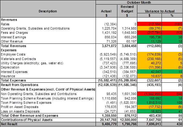
The month of October produced an overall favourable net result variance of $7.7m (430%).
Operating Revenues presented a slight unfavourable variance of -$113K (3%). Fees and Charges produced an unfavourable variance of -$217K (-13%) mainly through bulk rubbish collection fees (-$241K) as a result of the cessation of the uplift of bulk waste with the City of Joondalup. This was however moderately offset by higher animal registration fee income (+$128K). Interest income produced a positive variance for October of +$196K mainly through higher non-payment interest penalties relating to rates.
Operating Expenses displayed a negative variance of -$323K (-2%). The more substantial contributor to this variance was Materials & Contracts (-$230K). Within Materials & Contracts the Contract Expenses produced an unfavourable variance of (-$823K). This variance was attributed to previous invoice discrepancies being rectified and paid as well as expenses relating to turf and turf related renovations, weed control and wetting agent application that had been delayed over prior months due to unfavourable weather.
This was however offset through the lower refuse removal expenses in October (+$320K) due to the uplift of bulk waste with the City of Joondalup. Employee expenses also produced a negative variance in October (-$174K). This is mainly through the timing of annual leave which has been accruing quicker than anticipated. The People and Culture service unit is proactively monitoring and managing this area.
Other Revenue & Expenses produced a favourable variance of +$483K (+55%) which was mainly attributed to Town Planning Scheme Expenses (+$1.8m). This is due to a payment amount yet to be agreed relating to cells 5 and 8 which has not been paid and is continuing to be discussed. This was offset however through Non-Operating Grants, Subsidies and Contributions (-$1.5m) through timing of state and federal grants which did not have any receipts in October.
The month of October also recognised a parcel of developer contributed assets totalling $20.1m. Historically this category of income is recognised at year end however through requests to developers relevant interim data has been received and recorded. The budgets have now also been reflected quarterly.
The graphs below illustrate the various operating income categories for each month and are compared against their respective monthly budgets. Rates have been excluded as almost the entire income amount for this category is received in one month. Rates income is presented in a graph further in this report titled “Operating Revenues – Cumulative YTD (Actual vs Budget)”.
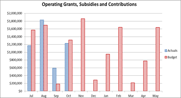
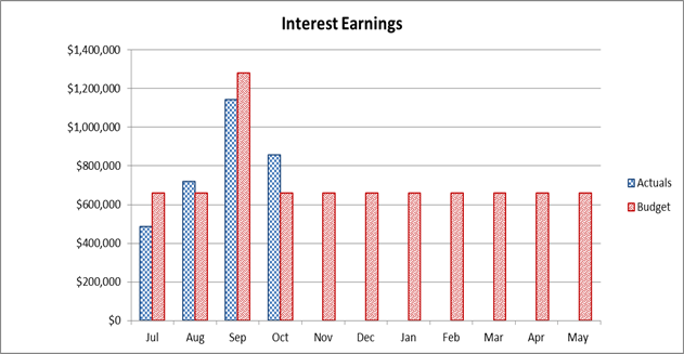
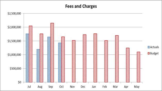
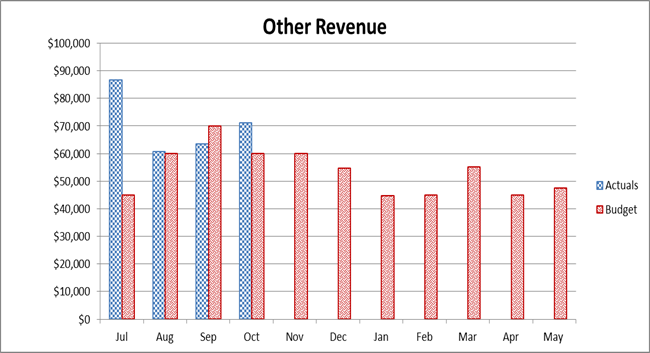
The following graphs represent the operating expenditure for each month and are compared against their respective monthly budgets. As a non-cash expense, depreciation has been excluded from these graphs but is shown as part of the graph titled “Operating Expenses – Cumulative YTD (Actual vs Budget)”.

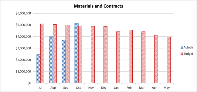
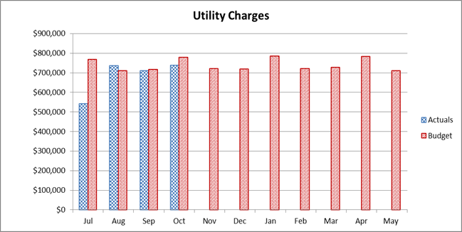

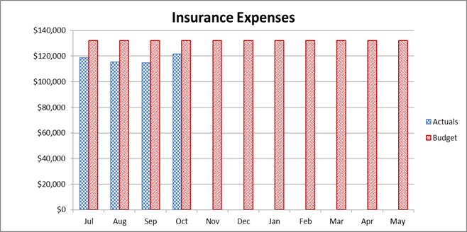
Income Statement (Refer to Attachment 1)
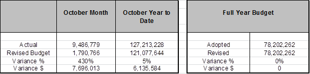
Year to Date (YTD) Net Result
The year to date Net Result presented a favourable variance of +$7.7m (+430%). Details for the variances are outlined below.
Operating Revenues
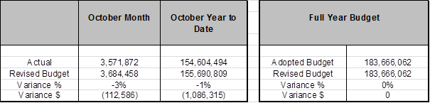
The Year to October produced an unfavourable variance of -$1.1m (-1%) comprising the following:
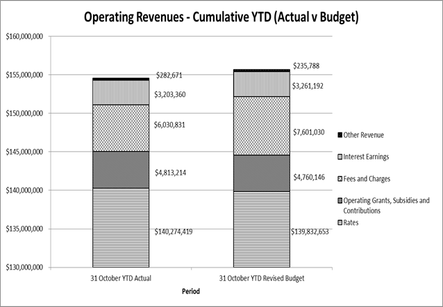
Fees and Charges (Actual $6.0m, Revised Budget $7.6m)
This income category produced an unfavourable variance of -$1.6m (-21%) to October. This relates to lower bulk rubbish collection fees (-$1.7m) as a result of the cessation of the uplift of bulk waste with the City of Joondalup. This was marginally offset by higher parking fine income (+$109K) to October as well as Application Fee income (+$102K), particularly Health Assessment Services where income has been recognised however not expected until June 2017.
Other Revenue (Actual $283K, Revised Budget $236K)
The result to October produced a positive variance of +$47K (+20%). This was a result of higher than expected street signage income as well as modification income for miscellaneous roads and footpath works. This was however slightly offset by lower fire mitigation income due to seasonal conditions.
Operating Expenses

Operating Expenses to October present a positive variance of +$4.7m (+8%). The above table highlights the month, YTD and full budget results which are further expanded in the section below. As with Operating Revenue, a bar graph is also included allowing comparison of expenditure categories.
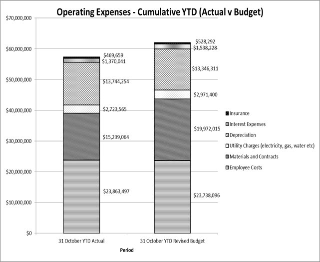
Materials and Contracts (Actual $15.2m, Revised Budget $20.0m)
This category of expenses displayed a positive YTD variance of +$4.7m. The main contributor for the variance pertains to Contract Expenses which produced a YTD variance of (+$2.9m). This is a result of a number of factors including delays to irrigation and associated repair works due to seasonal factors, a reduction in annual prescription burns due to weather conditions, staggered start to weeding programs due to the unseasonal cold spring as well as turf renovations. It is also noted that some programs where expenditure will be substantial are arterial road improvement works, street tree pilot program and general tree purchasing, all of which will take place between February and May 2017. Refuse removal expenses also produced a positive variance (+$1.3m) to October which was mainly a result of lower bulk rubbish collection expenditure through the cessation of Joondalup services. Another contributor was domestic rubbish collection which saw a positive variance of +$680K YTD through lower service activity.
Interest Expenses (Actual $1.4m, Revised Budget $1.5m)
Interest expenses produced a favourable YTD result of +$170K. This is a result of the deferred drawdown of a loan for the Yanchep DCP.
Insurance Expenses (Actual $470K, Revised $528K)
The year to date produced a positive result of $59K which is a result of annual premiums being slightly lower than budgeted.
Other Revenue and Expenses
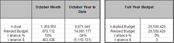
Non-Operating Grants, Subsidies and Contributions (Actual $1.3m, Revised Budget $6.5m)
This category of income produced an unfavourable YTD variance of -$5.2m (-81%). This is attributed to the timing of expected grants which are yet to be received.
Town Planning Scheme (TPS) Revenues (Actual $8.2m, Revised Budget $9.4m)
This category of income showed an adverse variance to October of -16% (-$1.6m). This is attributed to Lot Sale contributions across various TPS Cells. The Cells with YTD unfavourable variances are Cell 1 (-$877K), Cell 4 (-$372K) and Cell 9 (-$4.0m) which are a result of lower lot creations due to current property market conditions. These were however offset by Cell 2 which had favourable YTD activity of +$610K, Cell 5 (+$1.3m), Cell 6 (+$1.4m) and Cell 8 (+$491K). The cells with favourable variances are predominantly a result of prior period payments being recognised. These categories of income do not impact the City’s municipal operations.
Town Planning Scheme Expenses (Actual $1K, Revised Budget $1.8m)
This category of expense presented a positive variance of +$1.8m (+100%). This is due to a payment amount yet to be agreed relating to cells 5 and 8. This has not been paid and discussions relating to settlement amounts are ongoing.
Profit / Loss on Asset Disposals (Actual $448K, Revised Budget $611K)
The result to October displays a positive variance of -$163K (-27%). This is a result of lower sale of asset activities than anticipated. As activity volume cannot be reliably estimated budgets can be subject to variations due to activity levels.
Contributed Assets (Actual $20.1m, Revised Budget $12.5m)
The year to October recognised a parcel of developer contributed assets totalling $20.1m. Historically this category of income is recognised at year end however through requests to developers relevant interim data has been received and recorded. The budgets have now also been reflected quarterly.
Statement of Financial Position (Refer to Attachment 2)
The Statement of Financial Position as at October month end presents a consistent level of operations. When compared to the position as at 30 June 2016 Net Assets have increased by $127.0m and largely reflects the timing of rates and rates related receipts for 2016/17.
Non-Current Assets have increased by $22.7m from 2015/16 which is attributed mainly to the recognition of contributed physical assets from developers in October as well as works in progress.
Non-Current Liabilities remain unchanged with 98% of this balance being directly related to the Western Australia Treasury Corporation loan.
RATIOS
The table below shows selected ratios for the month ending 31 October and are compared against 2015/16 end of year:
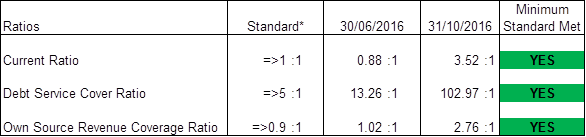
* Standard rates set by the Department of Local Government & Communities.
The Current Ratio provides information on the ability of the City to meet its short-term financial obligations from unrestricted current assets. At October 2016/17 the City has a Current Ratio of 3.52:1 which was higher than the benchmark of 1:1 provided by the Department of Local Government and Communities (DLGC). The reason for the positive outcome is due to the quantum of Receivables $72.5m (mainly Rates) when compared to the total for Payables & Provisions ($40.5m). The Current Ratio at 2015/16 year end was 0.88:1. This ratio typically decreases as the year progresses due to receivable balances reducing after rates have been raised and expenditure on operating and capital works is realised.
The Debt Service Cover Ratio is the measurement of the City’s ability to produce enough cash to cover its debt payments. The City’s Debt Service Cover Ratio at October month end was 102.97:1 which was materially higher than the DLGC benchmark of 5:1. This was a result of the annual Rates billings ($140.0m) against the comparatively small value of Interest payments ($1.4m). The Debt Service Cover Ratio at 2015/16 year end was 13.26:1. Similar to the current ratio the debt service ratio reduces throughout the year as expenditures are realised.
The Own Source Revenue Coverage Ratio is the measurement of the City’s ability to cover its costs through its own revenue efforts. The City’s Own Source Revenue Coverage Ratio at October month end was 2.76:1 which exceeds the DLGC benchmark of 0.9:1. This outcome reflects the raising of the annual Rates charges at the start of the financial year, as noted above. The Own Source Revenue Coverage Ratio at 2015/16 year end was 1.02:1.
Capital Works Program
The current status of the Capital Works Program as of 31 October 2016 is summarised below by Program Category.
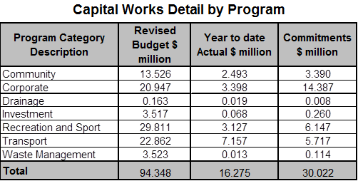
Key infrastructure projects are itemised on the Top Capital Projects attachment to this report: (Refer to Attachment 3)
As at October 31 the budget for capital works has been revised upwards by $1.1m. This relates to the carry forward adjustments presented in the September report.
The year to date expenditure relating to carry forward projects has increased by $1.2m from September to $8.2m as at 31st October. A review of actual spend indicates that key projects involved with this underspend include the Vehicle Replacement program for Domestic Waste Management, Yanchep District Playing Fields, Enterprise Software Renewal Program and the Construction of Flynn Drive, Neerabup. Expenditure on carry forward projects is increasing in November, with construction commencing on multiple projects with the successful completion of tendering processes.
Investment Portfolio Summary (Refer to Attachment 4)
In accordance with the Local Government (Financial Management) Regulations 1996, the City only invests in the following highly secured investments effective from 1 August 2012:
1. Deposits with authorised deposit taking institutions and the Western Australian Treasury Corporation for a term not exceeding 12 months;
2. Bonds that are guaranteed by the Commonwealth Government or a State or Territory for a term not exceeding three years; and
3. Australian currency.
As at 31 October 2016 the City holds an investment portfolio (cash & cash equivalents) of $368.6m (Face Value). Interest Earnings were budgeted at a 3.00% yield. For the financial YTD ending October 2016 the City’s investment portfolio return has exceeded the Bank Bill index benchmark by 0.61% pa (2.75% pa vs. 2.14% pa).
Displayed below are graphical representations of the portfolio performance and earnings.
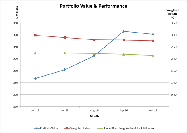
Rate Setting Statement (Refer to Attachment 5)
The Rate Setting Statement outlined in Attachment 5 represents a composite view of the finances of the City identifying the movement in the Surplus / (Deficit). This is based on the capital works and revenue & expenditure, and the resulting Rating Income required.
Statutory Compliance
This monthly financial report complies with Section 6.4 of the Local Government Act 1995 and Regulations 33A and 34 of the Local Government (Financial Management) Regulations 1996.
Strategic Implications
The proposal aligns with the following objective within the Strategic Community Plan 2013 – 2023:
“4 Civic Leadership - Working with others to ensure the best use of our resources.
4.3 A Strong and Progressive Organisation - You will recognise the hard work and professionalism delivered by your council through your interactions and how our community is developing.”
Risk Management Considerations
|
Risk Title |
Risk Rating |
|
Financial Management |
Moderate |
|
Accountability |
Action Planning Option |
|
Executive Management Team |
Manage |
The above risk relating to the issue contained within this report has been identified and considered within the City’s corporate risk register. Action plans have been developed to manage this risk to improve the existing management systems.
Policy Implications
Nil
Financial Implications
As outlined above and detailed in Attachments 1 - 5.
Voting Requirements
Simple Majority
That Council RECEIVES the Financial Activity Statements and commentaries on variances to YTD Budget for the period ended 31 October 2016, consisting of:
1. 2016/17 Annual Adopted and Revised Budget;
2. October 2016 YTD Revised Budget;
3. October 2016 YTD Income and Expenditure;
4. October 2016 Statement of Financial Position and Net Current Assets; and
5. October 2016 YTD Material Variance Notes.
Attachments:
|
1⇩. |
October Income Statement |
16/383286 |
Minuted |
|
2⇩. |
October Balance Sheet |
16/383289 |
Minuted |
|
3⇩. |
Top Projects 2016-17 - October 2016 - 20161109 |
16/151914[v8] |
Minuted |
|
4⇩. |
October Inv |
16/383295 |
Minuted |
|
5⇩. |
October RSS |
16/383299 |
Minuted |
CITY OF WANNEROO Agenda OF Elected Members' Briefing Session 29 November, 2016 417
Customer & Information Services
File Ref: 3042 – 16/375846
Responsible Officer: A/Director Corporate Strategy & Performance
Disclosure of Interest: Nil
Attachments: 1
Issue
To endorse the Our Customer Service Commitment.
Background
The City’s current Customer Service Charter was endorsed at Ordinary Council Meeting on 1 May 2012 (CB01-05/12). Although the City of Wanneroo has been achieving some key aspects of the current Customer Service Charter since it was endorsed, it is now timely to review and revitalise the Customer Service Charter in order to incorporate the City’s Customer First Strategy and to portray the City’s commitment of delivering service excellence.
The revitalised Customer Service Charter will set the standards for employees to follow as well as detailing for our customers the service they can expect to receive.
Detail
The previous Customer Service Charter was developed with a focus on customer service commitments that were clear, simple and to the point with an emphasis around the method of how customers contact the City.
The Customer Service Charter which is proposed to be renamed ‘Our Customer Service Commitment’ (attachment 1), continues to focus heavily on customer service commitments however with a focus on a consistent standard of customer service through every customer interaction and ensures customer service commitments are clear, simple and to the point. The name change from Customer Service Charter to ‘Our Customer Service Commitment’ arises in order to display to our customers the purpose of the publication.
The refreshed ‘Our Customer Service Commitment’ will assist in the deployment of the City’s planned approach to culture and the City’s overall results and performance in order to improve customer satisfaction and customer experience. It will also assist in the deployment of the Customer First Strategy’s approach to quality by ensuring consistency in the customer service experience across multiple channels.
Alongside the revitalised Customer Service Charter, some corporate customer service standards have been developed (e.g. that demonstrate to employees how to answer a telephone and what contact control techniques can be used when dealing with customer enquiries). Together these documents will support the alignment of the Customer First Strategy to the City’s broader strategic planning process and assist in the City’s approach to People, Information & Knowledge and Performance, and will be used as a basis in developing corporate customer service training for all employees.
The draft ‘Our Customer Service Commitment’ outlines the text of the proposed revitalised document and is subject to graphics approval by the City’s Communication, Marketing & Events team.
The use of colour throughout the document will be considered to ensure the document is visually accessible to community members and it will outline that it will be available in alternative hardcopy formats on request and will also be accessible via the City’s website.
Consultation
Research has been undertaken to compare other Customer Service Charters across Local Government. Extensive consultation within the organisation has also occurred to develop a refreshed and draft version of ‘Our Customer Service Commitment’ through workshops held in April 2016. Representatives from all service units, including management level, attended workshops and feedback from this assisted in the development of the proposed document based on key operational and customer service principles and through identifying what the City is currently doing well and where we could improve. Following the workshops, feedback was sought from all Coordinators, Managers and Executives.
Comment
There are several factors that impact the City with regards to current trends and issues affecting customer contact, including the continued growth of the City’s northern corridor. As more people and businesses move into the City we need to be efficient, effective and innovative to keep up with the growing demand and needs of our customers. ‘Our Customer Service Commitment’ supports the City’s Compliments, Feedback and Complaints Policy & Management Procedure and will assist in reducing inefficient customer service and dissatisfaction to our customers.
Statutory Compliance
Nil
Strategic Implications
The proposal aligns with the following objective within the Strategic Community Plan 2013 – 2023:
“4 Civic Leadership - Working with others to ensure the best use of our resources.
4.3 A Strong and Progressive Organisation - You will recognise the hard work and professionalism delivered by your council through your interactions and how our community is developing.”
Risk Management Considerations
|
Risk Title |
Risk Rating |
|
ST-S23 Stakeholder Relationships |
Moderate |
|
Accountability |
Action Planning Option |
|
CEO |
Manage |
|
Risk Title |
Risk Rating |
|
CO-O01 Relationship Management |
Moderate |
|
Accountability |
Action Planning Option |
|
Executive Management Team |
Manage |
The above risks relating to the issue contained within
this report has been identified and considered within the City’s
Strategic and Corporate risk register. Action plans have been developed to
manage this risk to support existing management systems.
Policy Implications
Nil
Financial Implications
Costs associated with ‘Our Customer Service Commitment’ have been included in the operating budget for 2016/17.
Voting Requirements
Simple Majority
That Council:-
1. ENDORSES the ‘Our Customer Service Commitment’ as in Attachment 1; and
2. NOTES that the new ‘Our Customer Service Commitment’ supersedes the previous ‘Customer Service Charter’.
Attachments:
|
1⇩. |
DRAFT Our Customer Service Commitment |
16/399780 |
Minuted |
CITY OF WANNEROO Agenda OF Elected Members' Briefing Session 29 November, 2016 425
Council & Corporate Support
File Ref: 2855V02 – 16/377973
Responsible Officer: A/Director Corporate Strategy & Performance
Disclosure of Interest: Nil
Attachments: 1
Issue
To consider requests for sponsorships, donations and waiver of fees in accordance with the City’s Donations, Sponsorships and Waiver of Fees and Charges Policy (Policy).
Background
The Policy requires applications over $500 from individuals and organisations to be determined by Council. Consequently a report is prepared for Council meetings, coinciding with a period where applications of this nature have been received.
With respect to requests for sponsorships, the Policy specifies that for National Events the amount provided will be $200.00 per individual, capped at $600.00 per team, and for International Events the amount provided is $500.00 per individual capped at $1,500.00 per team. Schools are capped at $2,000.00 per school per financial year.
Detail
During this period, the City has received two sponsorship requests, one community donation request and two requests for waiver of fees and charges, which are summarised as follows.
Comment
Sponsorship Donations
|
Applicant 1 – Wanneroo Lions Touch Association |
|
|
Name of Individual/s
|
U8’s - Mainaina Eiao, Leilyn Herewini and Charlie Dyer U10’s - Jackson McLean, Brodie Dunn, Kaden Te Wano, Hema Haturini, Amiria Edwards, Hope Marsh, Noah Marsh, Angelica Even and Electra Even U15s - Xavier Tearoa, Simon Waiomio, Deztain Stil, Alex Hill and Josh Streeter |
|
Reside in City of Wanneroo 18years of age or under |
Yes Yes |
|
Event Details |
Junior State Championships, Perth WA, 26 – 27 November 2016 |
|
Commitment to providing a written report regarding the event |
Yes |
|
Commitment to acknowledgement of the City of Wanneroo |
Yes |
|
Eligibility Level |
State (Western Australia) $75 each |
|
Comments
|
As per the policy $75.00 per individual (capped at $600 per club. |
|
Recommendation
|
APPROVE a request for sponsorship in the sum of $600.00 to Wanneroo Lions Touch Association for the participation of U8’s - Mainaina Eiao, Leilyn Herewini and Charlie Dyer; U10’s - Jackson McLean, Brodie Dunn, Kaden Te Wano, Hema Haturini, Amiria Edwards, Hope Marsh, Noah Marsh, Angelica Even and Electra Even; and U15s - Xavier Tearoa, Simon Waiomio, Deztain Stil, Alex Hill and Josh Streeter at the Junior State Championships to be held in Perth WA from 26 – 27 November 2016. |
|
Reason |
This request satisfies the criteria of Council's policy. |
|
Applicant 2 – Dakidz Inc |
|
|
Name of Individual/s
|
31 children as detailed in Attachment 1 |
|
Reside in City of Wanneroo 18years of age or under |
Yes Yes |
|
Event Details |
Showcase National Dance Championships, Gold Coast Qld 15 – 28 January 2017 |
|
Commitment to providing a written report regarding the event |
Yes |
|
Commitment to acknowledgement of the City of Wanneroo |
Yes |
|
Eligibility Level |
National $200 |
|
Comments
|
As per the policy $200.00 per individual (capped at $600 per team to a maximum of four teams per event). |
|
Recommendation
|
APPROVE a request for sponsorship in the sum of $600.00 to Dakidz Inc for the participation of 31 children (as detailed in Attachment 1) at the Showcase National Championships to be held in Gold Coast Qld from 15 – 28 January 2017. |
|
Reason |
This request satisfies the criteria of Council's policy. |
Community Group Donations
|
Applicant 3 – St Anthony’s Catholic Church |
|
|
Request amount |
$2,500.00 |
|
Description of request |
Request a donation to buy wool to support the project run by the social group Knit n Natter to make knee rugs for residents of City of Wanneroo nursing homes. |
|
Criteria |
Evaluation |
|
Potential for income generation |
Nil |
|
Status of applicant organisation |
Registered charity |
|
Exclusivity of the event or project |
Open to anyone in the community |
Alignment with Council’s existing philosophies, values and strategic direction |
2.2 – Healthy and active people – We get active in our local area and we have many opportunities to experience a healthy lifestyle. |
|
Alternative funding sources available or accessed by the organisation |
$500 |
|
Contribution to the event or activity made by the applicant or organisation |
Approximately 1,700 hours volunteer time |
|
Previous funding assistance provided to the organisation by the City |
CS04-09/13 $2,000.00 CS04-08/15 $2,500.00
|
|
Commitment to acknowledge the City of Wanneroo |
Yes |
|
Comments |
The organisers of the project aim to provide 250 knee rugs which cost approximately $12 each to make (when using 4 x 100g balls of wool at $3 per ball for each rug). The Church has submitted the application on this group's behalf as Knit n Natter is a social craft group and do not have a bank account. Council have supported similar requests previously. |
|
Recommendation |
APPROVE a request for a donation in the sum of $2,500.00 to St Anthony’s Catholic Church to buy wool to support the project run by the social group Knit n Natter to make knee rugs for donations to nursing homes throughout the City of Wanneroo. |
|
Reason |
This request is in accordance with Council’s Policy. |
|
Applicant 4 – Landsdale Community Wesleyan Methodist Church |
|
|
Request amount |
$798.30 |
|
Description of request |
100% waiver of bond, facility hire and bin hire at Warradale Hall and Park, plus electrician and St John Ambulance costs in order to hold the Landsdale Community Carols in the Park on 9 December 2016. |
|
Criteria |
Evaluation |
|
Potential for income generation |
Nil |
|
Status of applicant organisation |
Registered Charity |
|
Exclusivity of the event or project |
Open to all members of the public |
Alignment with Council’s existing philosophies, values and strategic direction |
2.2 – Healthy and active people – We get active in our local area and we have many opportunities to experience a healthy lifestyle |
|
Alternative funding sources available or accessed by the organisation |
$2,200.00 |
|
Contribution to the event or activity made by the applicant or organisation |
$2,793.40 plus 100+ hours volunteer time |
|
Previous funding assistance provided to the organisation by the City |
CD02-05/12 $800.00 CD03-04/13 $1,406.00 CD05-05/14 $796.80 CS06-12/15 $794.00 (plus waiver of bond) |
|
Commitment to acknowledge the City of Wanneroo |
Yes |
|
Comments |
In 2012, 2013 and 2014 this event was supported through the March Community Funding Rounds. In 2014 Council resolved to provide a $764.00 donation (plus waiver of bond). For the 2016 event, the costs currently required to be paid to the City are $850.00 bond, $172.80 facility hire fee and $52.50 bin hire fee. In addition to these costs, the applicant has requested the City to cover fees of $85 for an electrician and $488 for attendance by Event Health Services (St John Ambulance). Therefore, the total costs remaining to be paid are $798.30 fees and $850.00 bond. Clause 2(2.4) of the Policy states that “Council will not consider funding applications for…More than one application per financial year, including funding through the Community Funding Donation round” The applicant has already been provided a 50% subsidised use waiver of hire fees as a registered charity under the ‘Facility Hire and Use Policy’. Therefore a subsidy of $225.30 has been applied to this event. Clause 4.3 of the Policy does not support a 100% waiver of fees and this application is requesting that the remaining 50% also be waived. Clause 2.2 of the Policy states that Council will not consider funding applications for “The bond associated with the use of Council Facilities”. Christmas events are generally supported through the City’s Community Funding rounds. The City will continue to engage with the applicant regarding funding opportunities for future events. |
|
Recommendation |
NOT APPROVE a donation in the sum of $798.30 towards facility and bin hire at Warradale Hall and Park plus electrician and St John Ambulance costs, and NOT APPROVE the 100% waiver of bond to Landsdale Community Wesleyan Methodist Church for the Landsdale Community Carols in the Park to be held on 9 December 2016. |
|
Reason |
This request is not in accordance with Council’s Policy. |
|
Applicant 5 – Organization of African Communities WA Inc |
|
|
Request amount |
$1,071.00 |
|
Description of request |
Request a 50% waiver of fees for the OAC Football Tournament for South Sudan Youth (Stop the Violence through Sport) to be held from 3 – 18 December 2016 at Kingsway Regional Sports Complex. |
|
Criteria |
Evaluation |
|
Potential for income generation |
Nil |
|
Status of applicant organisation |
Not for profit |
|
Exclusivity of the event or project |
Open to African youth, CALD Youth and members from wider community |
Alignment with Council’s existing philosophies, values and strategic direction |
2.2 – Healthy and active people – We get active in our local area and we have many opportunities to experience a healthy lifestyle. |
|
Alternative funding sources available or accessed by the organisation |
Nil |
|
Contribution to the event or activity made by the applicant or organisation |
$4,000 plus $1,500 in-kind volunteer time |
|
Previous funding assistance provided to the organisation by the City |
Nil |
|
Commitment to acknowledge the City of Wanneroo |
Yes |
|
Comments |
This request is in accordance with clause 4.3 of the Donations, Sponsorships and Waiver of Fees and Charges Policy which states that: “Only 50% of the amount charged for a waiver of fees will be considered with the exception of State or Federal functions and visits by Parliamentarians held within the City.” |
|
Recommendation |
APPROVE a request for a donation in the sum of $1,071.00 to Organization of African Communities WA Inc for a 50% waiver of fees for the OAC Football Tournament for South Sudan Youth (Stop the Violence through Sport) to be held from 3 – 18 December 2016 at Kingsway Regional Sports Complex. |
|
Reason |
This request is in accordance with Council’s Policy. |
Statutory Compliance
Nil
Strategic Implications
The proposal aligns with the following objective within the Strategic Community Plan 2013 – 2023:
“2 Society - Healthy, safe, vibrant and active communities.
2.2 Healthy and Active People - We get active in our local area and we have many opportunities to experience a healthy lifestyle.”
Risk Management Considerations
There are no existing Strategic or Corporate risks within the City's existing risk registers which relate to the issues contained in this report.
Policy Implications
The Policy states that sponsorship applications for attendance at National Events will be capped at $600.00 per team (up to four teams) and Regional or State capped at $600 per club. International events will be capped at $1,500.00 per team and schools capped at $2,000.00 per school per financial year.
Financial Implications
|
Budget 2016/2017 |
|
$90 000.00 |
|
Amount expended to date (as at 10 November 2016) |
|
$54,685.00 |
|
Balance |
|
$35,315.00 |
|
Total of requests for this round: Donations (in this report):
Total this Round (recommended) |
$5,569.30 |
$4,771.00 |
|
BALANCE |
|
$30,544.00 |
Voting Requirements
Simple Majority
That Council:-
1. APPROVES a request for sponsorship in the sum of $600.00 to Wanneroo Lions Touch Association for the participation of U8’s - Mainaina Eiao, Leilyn Herewini and Charlie Dyer; U10’s - Jackson McLean, Brodie Dunn, Kaden Te Wano, Hema Haturini, Amiria Edwards, Hope Marsh, Noah Marsh, Angelica Even and Electra Even; and U15s - Xavier Tearoa, Simon Waiomio, Deztain Stil, Alex Hill and Josh Streeter at the Junior State Championships to be held in Perth WA from 26 – 27 November 2016;
2. APPROVES a request for sponsorship in the sum of $600.00 to Dakidz Inc for the participation of 31 children as shown at Attachment 2 at the Showcase National Championships to be held in Gold Coast Qld from 15 – 28 January 2017;
3. APPROVES a request for a donation in the sum of $2,500.00 to St Anthony’s Catholic Church to buy wool to support the project run by the social group Knit n Natter to make knee rugs for donation to nursing homes throughout the City of Wanneroo;
4. NOT APPROVE a donation in the sum of $798.30 towards facility and bin hire at Warradale Hall and Park plus electrician and St John Ambulance costs, and NOT APPROVE the 100% waiver of bond to Landsdale Community Wesleyan Methodist Church for the Landsdale Community Carols in the Park to be held on 9 December 2016; and
5. APPROVES a request for a donation in the sum of $1,071.00 to Organization of African Communities WA Inc for a 50% waiver of fees for the OAC Football Tournament for South Sudan Youth (Stop the Violence through Sport) to be held from 3 – 18 December 2016 at Kingsway Regional Sports Complex.
Attachments:
|
1⇩. |
Dakidz Inc List of Participants |
16/400007 |
Minuted |
CITY OF WANNEROO Agenda OF Elected Members' Briefing Session 29 November, 2016 433
Chief Executive Office
File Ref: 27713 – 16/390188
Responsible Officer: Manager Governance and Legal
Disclosure of Interest: Nil
Attachments: 1
Issue
To consider and endorse the Internal Audit Report – Regulation 17 Review which was completed in November 2016 by William Buck Consulting (WA) Pty Ltd (William Buck).
Background
Regulation 17 of the Local Government (Audit) Regulations 1996 (the Regulations) requires local governments to assess existing systems and procedures relating to risk management, internal controls and legislative compliance, and to develop an effective framework for ongoing monitoring and improvement of these systems and procedures.
The Regulations introduced additional requirements under Regulations 16(c) and 17 for the Audit Committee and the Chief Executive Officer (CEO) respectively, including extending the function of local government Audit Committees to now include reviewing the CEO's report on the appropriateness and effectiveness of the local government's systems in regard to risk management, internal control and legislative compliance; and reporting the results of the Committee's consideration of that review, to Council. The Regulations require that the report and review process should occur at least once every 2 calendar years.
The first review of the Regulation for the City of Wanneroo (City) was performed by KPMG, subsequently reviewed by the Audit and Risk Committee and reported to Council in December 2014.
The Internal Audit Report of Regulation 17 Review (2016) was presented by William Buck to the Audit and Risk Committee at its meeting on 22 November 2016 and the Audit and Risk Committee recommends Council adopt the Internal Audit Report of Regulation 17 Review (2016).
Detail
In accordance with the Internal Audit Plan 2016/17, William Buck was engaged to perform the review and assist the City to meet the Regulation 17 requirements.
This review focused on the design of the City’s business processes, control frameworks and operational effectiveness of key controls to ensure that the City achieves the following business objectives:
· A risk management framework is in place ensuring that the strategic, corporate and operational risks are identified, systematically evaluated, treated, regularly reviewed and reported.
· The City has reviewing processes in place to assess the effectiveness of internal controls.
· Formal recommendations are made to the City’s Audit and Risk Committee to address control weaknesses identified through the audit and review process.
· The implementation of recommendations made through the audit and review process are monitored and reported on.
· Legislative compliance requirements have been identified and roles and responsibilities for managing compliance are clearly defined and communicated.
· Reporting structures are in place to ensure instances of potential and actual non-compliance with legislation are appropriately escalated to management, the Audit and Risk Committee and Council.
· Follow up on previous Internal Audit Reports on Regulation 17.
Full details of the audit findings, recommendations and agreed management comments are documented in the Internal Audit Report of Regulation 17 Review (Attachment 1).
Consultation
In conducting the audit, William Buck engaged various service units that have responsibility for either design or implementation of the systems and processes relating to risk management, internal controls and legislative compliance in line with the agreed audit scope.
Comment
Based on the work performed, it was concluded that although processes and control frameworks have been implemented by the City to ensure that the City comply with Regulation 17 requirements, 2 high rated and 3 medium rated findings were identified which could potentially enhance the current systems.
The findings relate to the following:
· Finalisation of the formal Legislative Compliance and the Fraud and Misconduct Control and Resilience Frameworks;
· Development of an Overarching Internal Control Framework;
· Review of the Risk Management Policy, Procedures and software; and
· Development of the Internal Audit Charter and procedural manuals.
The table below provides a breakdown of the findings:
|
Area |
High |
Medium |
Low |
Total |
|
Legislative Compliance Framework |
1 |
- |
- |
1 |
|
Fraud and Misconduct |
1 |
- |
- |
1 |
|
Internal Controls |
- |
3 |
- |
3 |
|
Total |
2 |
3 |
- |
5 |
The findings and recommendations will be captured in the City’s Internal Audit Log and the remediation progress will be reported to the Audit & Risk Committee on a quarterly basis.
Statutory Compliance
Conduct of a biennial review of systems and processes relating to risk management, legislative compliance and internal controls is a requirement of the Local Government (Audit) Regulations 1996.
Strategic Implications
The proposal aligns with the following objective within the Strategic Community Plan 2013 – 2023:
“4 Civic Leadership - Working with others to ensure the best use of our resources.
4.3 A Strong and Progressive Organisation - You will recognise the hard work and professionalism delivered by your council through your interactions and how our community is developing.”
Risk Management Considerations
|
Risk Title |
Risk Rating |
|
Compliance Framework |
Moderate |
|
Accountability |
Action Planning Option |
|
Executive Management Team |
Manage |
The above risk relating to the issues contained within this report has been identified within the City’s corporate risk register which is reviewed and monitored bi-annually in accordance with the City’s reporting requirements.
Policy Implications
Policy implications from the recommendations contained within this audit will be considered and factored as part of the review of policies and procedures being undertaken in 2017.
Financial Implications
Any financial implications arising from this report will be considered and factored as part of the budget review process.
Voting Requirements
Simple Majority
That Council ACCEPTS the recommendation of the Audit and Risk Committee to adopt the CEO’s review of systems and processes as contained in the William Buck Internal Audit Report entitled Regulation 17 Audit Report (2016).
Attachments:
|
1⇩. |
Regulation 17 Audit Report 2016 - Final version |
16/385318 |
Minuted |
CITY OF WANNEROO Agenda OF Elected Members' Briefing Session 29 November, 2016 450
Governance & Legal
File Ref: 3131 – 16/389152
Responsible Officer: Manager Governance and Legal
Disclosure of Interest: Nil
Attachments: Nil
Issue
To consider changes to the delegated authority provided to the Chief Executive Officer (CEO) during the Council recess period.
Background
The last Ordinary Council Meeting for 2016 is scheduled for 6 December 2016 and the next Ordinary Council Meeting is scheduled for 7 February 2017 with Council being in recess during the period between the Ordinary Council Meetings. Should a decision be required during the period of recess that does not require an Absolute or Special Majority under the Local Government Act 1995 or any other Act empowering the local government, the CEO is authorised to make decisions in consultation with the Mayor or in the Mayor’s absence the Deputy Mayor on behalf of the City in accordance with delegation 2.5 in the Delegated Authority Register.
Decisions made during the recess period will be documented and reported to the first Ordinary Council meeting in 2017.
Detail
During this period four (4) public tenders will either close and/or the evaluation of these tenders will be undertaken with a recommendation finalised. For operational reasons it would be advantageous to award the tenders as soon as practicable. The relevant tenders during this period are as follows:
|
Tender No. |
Detail |
Tender Closing Date |
Estimated Contract Value |
|
16185 |
Construction of Marmion Avenue Duplication (Lukin Drive to Butler Boulevard) |
29 Nov 2016 |
$5,000,000 |
|
16188 |
Construction of Yanchep District Sports Amenities Building |
29 Nov2016 |
$3,280,000 |
|
16200 |
Construction of Yanchep Surf Life Saving Clubrooms |
8 Dec 2016 |
$3,500,000 |
|
16226 |
Park Assets Renewals 2016/17 |
6 Dec 2016 |
$950,000 |
Consultation
Nil
Comment
Council has supported this process and delegation of authority in previous years. A report of all decisions made in accordance with this delegation of authority will be provided to Council in February 2017.
Council to note that all tenders are evaluation in accordance with the requirements of the Local Government (Functions and General) Regulations 1996 and the City’s Purchasing Policy.
Statutory Compliance
Section 5.42 of the Local Government Act 1995 allows Council to delegate functions to the CEO. Section 5.43 does not permit Council to delegate authority to the CEO to award a tender above a limit set by Council.
Strategic Implications
The proposal aligns with the following objective within the Strategic Community Plan 2013 – 2023:
“4 Civic Leadership - Working with others to ensure the best use of our resources.
4.3 A Strong and Progressive Organisation - You will recognise the hard work and professionalism delivered by your council through your interactions and how our community is developing.”
Risk Management Considerations
|
Risk Title |
Risk Rating |
|
CO-C01 Compliance Framework |
Moderate |
|
Accountability |
Action Planning Option |
|
Executive Manager Governance & Legal |
Manage |
“The above risk/s relating to the issue contained within this report have been identified and considered within the City’s Corporate risk register. Action plans have been developed to manage this risk to support existing management systems.”
Policy Implications
Nil
Financial Implications
The awarding of any tender will be on the basis that adequate budget provision has been made.
Voting Requirements
Absolute Majority
That Council DELEGATE BY ABSOLUTE MAJORITY to the Chief Executive Officer the authority to DETERMINE and ACCEPT the following tenders during Council’s recess period from 6 December 2016 to 6 February 2017 only, within confirmed budgetary provisions and in accordance with the Local Government (Functions and General) Regulations 1996:
1. Tender 16185 Duplication of Marmion Ave (Lukin Drive to Butler Boulevard);
2. Tender 16188 Construction of Yanchep District Sports Amenities Building;
3. Tender 16200 Construction of Yanchep Surf Life Saving Clubrooms; and
4. Tender 16226 Park Assets Renewals 2016/17.
Attachments: Nil
CITY OF WANNEROO Agenda OF Elected Members' Briefing Session 29 November, 2016 453
File Ref: 25242 – 16/378338
Responsible Officer: Manager Governance and Legal
Disclosure of Interest: Nil
Attachments: 1
Issue
To consider a proposed amendment to the City of Wanneroo’s Public Places and Local Government Property Local Law 2016 (Public Places LL) to regulate unauthorised access and use of vehicles on City beaches.
Background
At its meeting held on 2 February 2016, Council resolved to make a new Public Places LL which was gazetted on 29 February 2016.
For some time now, the City has been dealing with the illegal access of vehicles, in particular four wheel drives onto the City’s beaches posing a significant risk to public safety and beach users. As part of a broader strategy to control and discourage this illegal activity, Administration considers it appropriate to increase the infringement penalties for such offences.
Detail
It is prohibited (and illegal) for vehicles to access or travel along the beaches within the City of Wanneroo district. It has been an ongoing issue that 4-wheel drives and other off-road vehicles constantly access and travel on the City’s beaches and foreshore reserves. Such access poses a safety risk to beach users and has been exacerbated by the development of new estates along the City’s coastal corridor. City representatives have met with respective landowners and other stakeholders to develop a strategy to combat this issue. The key components of the strategy are:
a) Investigation of the possibility of increasing the single and repeat offender fines for unauthorised access;
The City’s rangers have recently commenced issuing multiple infringement notices under the Parking LL and Public Places LL for single occurrences of contravention of the respective local laws. This has resulted in increased, compounded financial penalties of up to $600 (increased from $125) which is likely to be more of a deterrent to illegal access. The proposed amendments to the Public Places LL set out in this report now proposes a new provision and offence that specifically addresses the problem that allows for the maximum infringement penalty (being $500) for any non-compliance.
In addition to the increased financial penalties, Administration will consider prosecuting illegal access following a first offence (implementing a no tolerance policy) and impounding vehicles for repeat offenders.
b) Investigate the potential to expand the model for coastal patrols within the City, including the possibility of partnerships with landowners, police involvement and the legal aspects of patrolling private property
Administration is currently recruiting 4 coastal rangers to operate on Fridays, Saturdays and Sundays over the summer months. In addition, the City is investigating the potential use of drone technology and high resolution cameras to more effectively identify illegal access in real time and collate evidence. This will allow a more focussed and targeted use of coastal rangers and a more timely response to illegal access.
c) Collect information from landowners on where, when and how often illegal access is occurring.
Administration is currently collating and analysing the feedback received from landowners on this matter with a view to mapping this information to identify ‘hot spots’ and provide a clear picture of why and where further resources are required to assist with the issue.
d) Development and implementation of a communication strategy to inform stakeholders and the community of the significance of the issue and how it is being addressed.
This will include communicating all of the above measures via the City’s media channels, writing to known stakeholders and 4-wheel drive clubs and associations, installation of variable illuminated message signs in problem areas and developing simple campaign messages to discourage continued off-road vehicle activity.
The Amendment Local Law is set out at Attachment 1 and a summary is provided below.
1. New definitions for “beach” and “dune” to ensure that there is no ambiguity when determining whether the vehicle is in a prohibited area.
2. A new prohibition relating to vehicles on beaches and dunes to be inserted after 5.8 in the local law:-
“5.9 Unauthorised vehicles on beaches and dunes
A person must not cause a vehicle to be or drive a vehicle, on a beach or dune unless otherwise authorised or approved by the local government or any other public authority.”
3. A corresponding prescribed penalty of 50 penalty units (being $500).
Consultation
In accordance with Section 3.12(3) and (3a) of the Local Government Act 1995 the City is required to give State wide and local public notice of the proposed local law inviting submissions for a period of no less than six weeks after the notice is given.
Comment
There is a significant risk to the safety of beach users due to the illegal access of use of vehicles and notwithstanding the increase compliance regime, the significant penalty will contribute towards deterring offenders.
Regulation 3 of the Local Government (Functions and General) Regulations 1996 requires, for the purposes of Section 3.12 of the Local Government Act 1995, that the purpose and effect of any proposed local law must be included in the minutes of a meeting.
The purpose and effect of the proposed amendment local law is as follows:-
1. Public Places and Local Government Property Amendment Local Law
Purpose
To amend the City of Wanneroo Public Places and Local Government Property Local Law to include a provision specifically prohibiting use of vehicles on beaches and dunes.
Effect
To address a significant risk to the safety of beach users by providing a deterrent to offenders for non-compliance with the Public Places and Local Government Property Local Law within the City of Wanneroo district.
Statutory Compliance
Section 3.12 of the Act sets out the requirements for making a local law.
Strategic Implications
The proposal aligns with the following objective within the Strategic Community Plan 2013 – 2023:
“4 Civic Leadership - Working with others to ensure the best use of our resources.
4.3 A Strong and Progressive Organisation - You will recognise the hard work and professionalism delivered by your council through your interactions and how our community is developing.”
Risk Management Considerations
|
Risk Title |
Risk Rating |
|
Compliance Framework |
Moderate |
|
Accountability |
Action Planning Option |
|
Executive Management Team |
Mitigate |
The above risk relating to the issue contained within this report has been identified and considered within the City’s Corporate Operational risk register. Action plans have been developed to mitigate this risk to support existing management systems. The proposed amendments to the local laws to increase the penalty units applicable to the prescribed offences will provide effective deterrents for non-compliance.
Policy Implications
Nil
Financial Implications
There are costs associated with making the local law, including advertising and eventual Gazettal.
Voting Requirements
Simple Majority
Recommendation
That Council:-
1. In accordance with sections 3.12(3)(a) and (3a) of the Local Government Act 1995, GIVES state wide and local public notice stating that it proposes to make a Public Places and Local Government Property Amendment Local Law 2017, a summary of its purpose and effect being;
Purpose
To amend the City of Wanneroo Public Places and Local Government Property Local Law to include a provision specifically prohibiting use of vehicles on beaches and dunes.
Effect
To address a significant risk to the safety of beach users by providing a deterrent to offenders for non-compliance with the Public Places and Local Government Property Local Law within the City of Wanneroo district;
2. NOTES that:
a) copies of the proposed local law may be inspected at the City’s offices and will be made available on the City’s website;
b) submissions about the proposed Public Places and Local Government Property Amendment Local Law 2017 may be made to the City within a period of not less than 6 weeks after the notice is given;
c) in accordance with section 3.12(3)(b), as soon as the notice is given, a copy of the proposed local laws will be supplied to the Minister for Local Government; and
d) in accordance with section 3.12(3)(c) of the Local Government Act, a copy of the proposed Public Places and Local Government Property Amendment Local Law 2017 be supplied to any person requesting it; and
3. NOTES that all submissions received will be presented to Council for consideration.
Attachments:
|
1⇩. |
DRAFT - Public Place and Local Government Property Amendment Local Law |
16/378093 |
|
CITY OF WANNEROO Agenda OF Elected Members' Briefing Session 29 November, 2016 459
File Ref: 9167 – 16/389574
Responsible Officer: Manager Governance and Legal
Disclosure of Interest: Nil
Attachments: 2
Issue
To consider an amendment to Delegation 6.4 Choice of Most Advantageous Tender to provide the Chief Executive Officer the appropriate authority to accept tenders of up to $1,000,000 for projects that have been endorsed as part the City’s annual budget adoption process.
Background
Council’s Conditions on Delegation for Delegation 6.4 currently prescribe that the Delegation is subject to a provision in the Annual Budget and limited to:
· Tenders resulting from the expiry of a recurring contract - $5 million (life of contract);
· Supply of plant and equipment - $2 million;
· All other tenders - $250,000; and
· Subject to Regulation 18(4) and (5) of the Local Government (Functions and General) Regulations 1996.
Detail
In order to improve the efficiency of awarding tenders it is recommended that Council consider increasing the delegated authority limit to the Chief Executive Officer for the awarding of ‘All other tenders’ from $250,000 to $1,000,000 as shown in Attachment 1.
Within the category of ‘All other tenders’ over $250,000 the following tenders were presented to Council for approval:-
2014/15 - 10 (ten) tenders were awarded; and
2015/16 - 11 (eleven) tenders were awarded.
Preparing and presenting Tender reports for tenders within the category of ‘All other tenders from $250,000 to $1,000,000’ to Council can add an additional four weeks to the process where Council has already approved the projects via the annual budget process. Attachment 2 provides details.
The City has implemented robust processes in respect of procurement which align with the requirements of the City’s Purchasing Policy (as endorsed by Council) and the Local Government (Functions and General) Regulations 1996. Specifically in relation to the tender procurement process, a procurement plan setting out the scope of services/works required and the process to evaluate tenders must be approved by the respective Director prior to the tender being advertised. All tenders must be evaluated in accordance with the process set out in the procurement plan and with guidance from the Contracts and Procurement team.
Consultation
It is worthwhile noting that the City of Stirling sub-delegates the acceptance of tenders under this limit to their Directors subject to the sub-delegates undertaking procurement training
provided by the City and signing an annual declaration of understanding of the City’s Procurement Policy.
Comment
It is important for Council to note that delegating a power does not transfer that power to the delegate, it merely replicates it and Council retains the ability to exercise any power or duty delegated to the CEO. (s.59 Interpretation Act 1984).
The essential elements of a Council delegation are the correct and accurate identification of the:
· power or duty to be delegated;
· office to whom or which the power or duty is to be delegated;
· circumstances in which the power or duty can be exercised or discharged; and
· conditions on the exercise of the power or duty.
Statutory Compliance
Local Government Act 1995
Part 5 Administration
Division 4 Local government employees
5.42. Delegation of some powers and duties to CEO
(1) A local government may delegate* to the CEO the exercise of any of its powers or the discharge of any of its duties under —
(a) this Act other than those referred to in section 5.43; or
(b) the Planning and Development Act 2005 section 214(2), (3) or (5).
* Absolute majority required.
(2) A delegation under this section is to be in writing and may be general or as otherwise provided in the instrument of delegation.
5.43. Limits on delegations to CEO
A local government cannot delegate to a CEO any of the following powers or duties —
(a) any power or duty that requires a decision of an absolute majority or a 75% majority of the local government;
(b) accepting a tender which exceeds an amount determined by the local government for the purpose of this paragraph;
Strategic Implications
The proposal aligns with the following objective within the Strategic Community Plan 2013 – 2023:
“4 Civic Leadership - Working with others to ensure the best use of our resources.
4.3 A Strong and Progressive Organisation - You will recognise the hard work and professionalism delivered by your council through your interactions and how our community is developing.”
Risk Management Considerations
|
Risk Title |
Risk Rating |
|
Decision Making |
Low |
|
Accountability |
Action Planning Option |
|
Mayor & CEO |
Manage |
The above risk relating to the issue contained within this report has been identified and considered within the City’s Corporate Risk Register. Action plans have been developed to manage this risk to improve the existing management systems. The adoption of the proposed delegation will provide the appropriate authority for the CEO to accept tenders of up to $1,000,000 for projects that have been endorsed as part the City’s annual budget adoption process.
Policy Implications
Nil
Financial Implications
Approval of tenders of up to $1,000,000 is based on the premise that the projects have been endorsed in accordance with the City’s annual budget adoption process.
Voting Requirements
Absolute Majority
That Council, BY ABSOLUTE MAJORITY, delegate to the Chief Executive Officer the authority to accept tenders of up to $1,000,000 for projects that have been endorsed in accordance with the City’s annual budget adoption process.
Attachments:
|
1⇩. |
DRAFT - Amendment to Delegation 6.4 Choice of most advantageous tender |
16/319504 |
|
|
2⇩. |
Tenders Presented to Council Over $250k and under $1M |
16/328778 |
|
CITY OF WANNEROO Agenda OF Elected Members' Briefing Session 29 November, 2016 464
File Ref: 25245 – 16/391518
Responsible Officer: Manager Governance and Legal
Disclosure of Interest: Nil
Attachments: 1
Issue
To consider a new Bee Keeping Local Law (BKLL) for adoption as part of the City’s 8 Year Local Law Review (Review) required by the Local Government Act 1995 (the Act).
Background
Section 37 (Part 6) of the City’s Animals Local Law 1999 deals with bees and simply provides that a person (registered bee keeper) shall not keep a beehive in a residential area or a special rural area without written approval from the City. Some legislative change has occurred in this area, but the City is still required to regulate certain areas of the keeping and maintaining of bees that legislation does not cover. It is proposed to make a new BKLL to reflect these changes and include those measures to empower the City to respond to issues as they arise.
The proposed draft BKLL was adopted by Council at its meeting held on 1 March 2016 for the purposes of public advertising and the submission period closed on 13 May 2016. Four submissions were received from members of the public. A report was presented to the 7 June 2016 Council Forum where Elected Members expressed concerns that the proposed draft BKLL was too restrictive. Administration further investigated the provisions of the proposed draft BKLL and incorporated Elected Members’ feedback into an updated version.
The new draft BKLL was presented to Elected Members at the 30 August 2016 Council Forum for consideration. Questions raised at the Forum and responses from Administration were circulated to Members through the Forum Notes on Friday 2 September 2016.
A report was subsequently presented to Council on 13 September 2016 to progress the draft proposed BKLL for public advertising which was subsequently advertised for a 7 week period closing on 8 November 2016. Six submissions were received from the public.
Detail
There are minor consequential amendments from previous versions as a result of the consultation process, in particular clause 2.1(2) which in summary provides that a person may keep bees on any land except land zoned residential without the need to obtain a permit from the City providing that:
· before establishing the bee hives on the land, the occupier of the land notifies, in writing, the occupier of each property adjoining the land that the bee hives are to be kept;
· each bee hive is kept at least 10 metres from any thoroughfare (including a footpath) or public place and at least 5 metres from any other boundary of the land; and
· bees from the bee hives do not become a nuisance.
With respect to land zoned residential, the same applies, except that a person may only keep up to two hives.
Note that it may still be possible to keep bees on land where the above requirements are not met and this would require that the applicant obtain a permit from the City to do so, and comply with any permit conditions imposed by the City.
Consultation
The draft BKLL was advertised for public comment for a 7 week period closing on 8 November 2016. Six submissions were received from the public, who were all generally supportive of the draft BKLL (as amended and readvertised) and are summarised below.
|
Comment |
Recommended action |
|
The draft proposed law allows up to two hives in an urban setting without the need for a permit so long as certain positioning conditions are complied with. However, although attempting to take account of best practice guidelines for the positioning of hives in an urban environment the proposed law is still unnecessarily restrictive.
The key amendment recommended, to reduce the chance of nuisance bee behaviour even further while still maintaining a harmonious and neighbourly outcome, is to allow positioning of the hive on the boundary so long as the flight path from the entry of the hive is either parallel to the boundary or away from the boundary. Positioning of hives in this manner is proven to work and reduce nuisance issues.
Another recommended amendment, to still further reduce the chance of nuisance bee behaviour, is to also require the provision of a bee-suitable water source. |
In relation to positioning of hives, clause 2.1 (1) of the draft local law requires a person wishing to keep bees to obtain a permit - except as provided in clause 2.1(2) which sets out the conditions under which a permit is not required, including distances from side and front boundaries.
A good and sufficient supply of water on every apiary site is provided in a way that is readily accessible to the bees on that site … This further supports the Regulation 90 of the Biosecurity and Agriculture Management Regulations 2013 which provides that unless water is available from natural sources, every beekeeper must provide a good and sufficient supply of water on every apiary site (ie a site occupied by one or more beehives) in a way that is readily accessible to the bees on that site. |
|
I support the Proposed Bee Keeping Local Law 2016. This could really help our environment. |
Noted. |
|
I support the Proposed Bee Keeping Local Law 2016. |
|
|
I support the upkeep of Bees. Without bees plants /flowers/fruit will not be pollinated. It is essential that all areas of Western Australia support and encourage the increase of the bee population. Hoping the Council of Wanneroo promote and pioneer the keeping and breeding of the bee population. |
|
|
I support the proposed bee keeping local law 2016. I am impressed that the City of Wanneroo is taking such a positive step forward which will benefit the future of bees, the environment and the quality of life of residents within Wanneroo. If the new law gets passed, hopefully other Councils will follow the excellent example set by City of Wanneroo. Thank you again, I am proud to be a resident of the City of Wanneroo. |
|
|
I support the Proposed Bee Keeping Local Law 2016. This is a positive step in the right direction to prevent the decrease in the number of bees. |
|
|
One submission was received after the closure of the comment period. It appears related at least in part to a submission by another person in relation to an application to keep bees being heard by the State Administrative Tribunal.
A summary is: Clause 2.1(1) of the proposed local law (Permit required to keep bees) is supported but subclause 2.1(2) (requirement to notify adjoining properties) is not – ‘Totally unnecessary, some people just object to bees through shear (sic) ignorance. Most people have bees on their property whether the neighbour has bees or not. Bees in the suburban area would range up to two km. Most people in urban areas do not know whether their neighbour has bees or not. The restriction does not apply to dogs which are subject to 1,000’s of complaints.’
In relation to clause 2.2(b)(iii) (no permit required if each bee hive is kept at least 10 metres from any thoroughfare (including a footpath) or public place and at least 5 metres from any other boundary of the land): ‘The SAT has ruled it is better to place the bees close to a fence if the fence is solid as it forces the bees to rise at a much greater angle’. |
As detailed above, clause 2.1 (1) of the draft local law requires a person wishing to keep bees to obtain a permit – but if they are able to comply with the matters provided in clause 2.1(2) a permit is not required. One of those matters simply requires them to notify adjoining properties.
There is no reason why the City cannot give a permit to an applicant who is not otherwise exempt under clause 2.1(2) in relation placing a hive in relation to distances from side or front property boundaries, providing that an authorised person is satisfied that a permit should be issued.
No changes to the proposed local law are recommended. |
|
The WA Farmers Federation wrote in support of the proposed local law: ‘WAFarmers supports the City of Wanneroo in developing these laws to allow for hobbyist apiarists to keep up to 2 hives in their backyards, with a number of provisions. We hope that a number of other local Councils look at the initiative the City of Wanneroo has taken, and make changes to their existing apiary restrictions.’ |
Noted. |
|
The WA Department of Agriculture suggested that the City make an addition to clause 2.1(a): A beekeeper must identify every hive the beekeeper owns, or cause it to be identified, with the beekeeper's registered identifier for hives applied in accordance with regulation 203 of the Biosecurity and Agriculture Management (Identification and Movement of Stock and Apiaries) Regulations 2013. |
There is no need to amend the local law to reflect this requirement as it is already in the Regulations, but it is recommended that an addition to the text box in the administrative version of the local law could be added. |
|
The WA Department of Local Government and Communities recommended a number of minor changes:
Clause 1.3 – Repeal It is suggested that the date of publication in the Government Gazette of the repealed local law be included in the repeal clause.
Clause 1.5 – Terms used It is suggested that the City inserts a definition for each of the following terms which are used in the local law: · boundary · thoroughfare · public place · Schedule
Whilst not all of these definitions are necessary, they may assist readers and reduce the possibility of misinterpretation.
Bee keeper registration – exemptions Clause 2.1(1)(a) of the local law requires a person to be a registered bee keeper when keeping bees.
Regulation 13 of the Biosecurity and Agriculture Management (Identification and Movement of Stock and Apiaries) Regulations 2013 provides that a person does not need to be a registered beekeeper to keep bees for pollination purposes.
It appears that the City has several kinds of rural zones. If these zones are likely to contain any kind of crops, the City may wish to account for the exemption in the Regulations.
Clause 3.2 – Offences and general penalty Clauses 3.2 establishes a penalty of $5,000 and a daily penalty of $500. The Committee has recently expressed concerns with this kind of wording. As the clause is currently written, it may be interpreted to mean that the daily penalty of $500 would occur on the first day, along with the $5,000 penalty. This would mean that the total penalty is $5,500, which is inconsistent with the Local Government Act 1995 that imposes a maximum penalty of $5,000.
It is suggested that the clause be redrafted to include “where the offence is of a continuing nature”. |
Not agreed, these terms are in common use.
Agreed. |
The WA Department of Local Government and Communities also recommended a number of minor edits, which have been undertaken.
Comment
The provisions of the BKLL have been relaxed from the version previously considered by Council and are considered a reasonable balance between encouraging bee keeping and protection of the community from bees.
The amendments suggested are shown ‘marked up’ in Attachment 1 and are considered minor in nature.
The BKLL can now be finalised, and will come into effect 14 days after its publication in the Government Gazette.
The Act requires the person presiding at a Council meeting to give notice of the purpose and effect of the proposed local law by ensuring that the purpose and effect is included in the agenda for the meeting and that the minutes of the meeting include the purpose and effect of the proposed local law:
Purpose
The purpose of the proposed Bee Keeping Local Law is to regulate beekeeping within the City of Wanneroo.
Effect
The effect of the proposed Bee Keeping Local Law is that persons must comply with the requirements of the local law when keeping bees.
Statutory Compliance
The provision in the City’s Animals Local Law in relation to bees is based on the Bee Keeper’s Act 1963, but which was repealed in 2013. The major State legislative provisions governing bee keeping are now in:-
1. The Biosecurity and Agriculture Management (Identification and Movement of Stock and Apiaries) Regulations 2013 – including:
a) Part 2, Divisions 3 and 4 (dealing with the registration of beekeepers).
b) Part 9 (regulations 202-210), dealing with the identification and movement of apiaries, and
c) The definitions in regulation 3 of the terms ‘apiary’, ‘beekeeper’ and ‘registered beekeeper’; and
2. The Biosecurity and Agriculture Management Regulations 2013 – including regulations 19 and 86-90 and the definitions in regulation 3 of the terms ‘apiary’, ‘beekeeper’ and ‘hive product’.
The Biosecurity and Agriculture Management Act 2007 (Biosecurity Act) and associated regulations are administered by the WA Department of Agriculture and Food and beekeepers are required to be registered with this Department. The City’s role is secondary.
Many issues associated with bees relate to water, or a lack of it. Regulation 90 of the Biosecurity and Agriculture Management Regulations 2013 imposes an obligation for every beekeeper to provide a good and sufficient supply of water on every apiary site in a way that is readily accessible to the bees on that site, a breach of which attracts a maximum penalty of $10,000.
In addition, based on previous decisions, the WA Parliamentary Joint Standing Committee on Delegated Legislation (JSCDL) has effectively limited the range of matters in respect of which a local law can provide for a notice to be issued requiring an owner or occupier (or other person) to take action.
As a result of the JSCDL’s views, local laws have been disallowed where notice provisions purport to go beyond the matters listed in Schedule 3.1 the Act. Under Schedule 3.1 of the Act, a local government may serve a notice on an owner or occupier to –
‘Remove bees that are likely to endanger the safety of any person or create a serious public nuisance’.
If the notice is not complied with, the local government may carry out its requirements and recover the cost of doing so from the property owner.
As such, the matters included in the proposed new local law reflect the provisions of the Biosecurity Act and the Act and are designed to complement them. In addition, section 3.12 of the Act sets out the requirements for making a local law.
Strategic Implications
The proposal aligns with the following objective within the Strategic Community Plan 2013 – 2023:
“4 Civic Leadership - Working with others to ensure the best use of our resources.
4.3 A Strong and Progressive Organisation - You will recognise the hard work and professionalism delivered by your council through your interactions and how our community is developing.”
Risk Management Considerations
There are no existing Strategic or Corporate risks within the City's existing risk registers which relate to the issues contained in this report. However the making of the Bee Keeping LL will allow the City to better deal with managing bee keeping in the district.
Policy Implications
Nil
Financial Implications
There are costs associated with making the local law, including advertising and eventual Gazettal.
Voting Requirements
Absolute Majority
That Council:-
1. ADOPTS BY ABSOLUTE MAJORITY, in accordance with section 3.12(4) of the Local Government Act 1995, the City of Wanneroo Bee Keeping Local Law 2016 as set out in Attachment 1, subject to:
a) deletion of text boxes, page numbers, index and notes in the version to be officially Gazetted; and
b) acceptance of various other amendments displayed in ‘mark up’;
2. NOTES the purpose and effect of the local law as:-
Purpose
The purpose of the proposed Bee Keeping Local Law is to regulate beekeeping within the City of Wanneroo.
Effect
The effect of the proposed Bee Keeping Local Law is that persons must comply with the requirements of the local law when keeping bees;
3. REQUESTS Administration in accordance with s3.12(5) of the Local Government Act 1995 publish the City of Wanneroo Bee Keeping Local Law in the Government Gazette and sends a copy to the Ministers for Local Government and Communities and Agriculture and Food;
4. NOTES that after Gazettal, in accordance with s3.12(6) of the Local Government Act 1995, local public notice be given —
a) stating the title of the local law;
b) summarising the purpose and effect of the local law (specifying the day on which it comes into operation); and
c) advising that copies of the local law may be inspected or obtained from the City office; and
5. NOTES that following Gazettal, in accordance with the Local Laws Explanatory Memoranda Directions as issued by the Minister on 12 November 2010, a copy of the local law and a duly completed explanatory memorandum signed by the Mayor and Chief Executive Officer be sent to the Western Australian Parliamentary Joint Standing Committee on Delegated Legislation.
Attachments:
|
1⇩. |
DRAFT Bee Keeping Local Law 2016 for Adoption by Council |
16/391599 |
Minuted |
CITY OF WANNEROO Agenda OF Elected Members' Briefing Session 29 November, 2016 483
Item 4 Motions on Notice
Item 5 Late Reports (to be circulated under separate cover)
7.1 Amendment to Existing Report: Acquisition of Land from Lot 8 (289) and Lot 14 (286) Gnangara Road for the Upgrade of Gnangara Road
File Ref: 9472 – 16/392265
Responsible Officer: A/Director Corporate Strategy & Performance
This report is to be dealt with in confidential session, under the terms of the Local Government Act 1995 Section 5.23(2), as follows:
(c) a contract entered into, or which may be entered into, by the local government and which relates to a matter to be discussed at the meeting
(h) such other matters as may be prescribed (consider regulations)
The next Ordinary Council Meeting has been scheduled for 6:00pm on Tuesday 6 December 2016 to be held at Council Chambers, Civic Centre, 23 Dundebar Road, Wanneroo.