Council Agenda
Ordinary Council Meeting
7.00pm, 24 July 2018
Council Chambers, Civic Centre, Dundebar Road, Wanneroo
Council Agenda
Ordinary Council Meeting
7.00pm, 24 July 2018
Council Chambers, Civic Centre, Dundebar Road, Wanneroo
PUBLIC QUESTION AND STATEMENT TIME
1. TIME PERMITTED
A minimum of 15 minutes is permitted for public questions at each Council Meeting. If there are not sufficient questions to fill the allocated time, the person presiding will move to the next item. If there are more questions than can be considered within 15 minutes, the person presiding will determine whether to extend question time. Each person seeking to ask questions during public question time may address the Council for a maximum of 3 minutes each.
2. PROTOCOLS
No member of the public may interrupt the meeting’s proceedings or enter into conversation.
Members of the public wishing to ask a question/s at the Council Meeting are to register on the night at the main reception desk located outside of the Chamber. Members of the public wishing to submit written questions are requested to lodge them with the Chief Executive Officer at least 30 hours prior to the start of the meeting (that is by noon on the day before the meeting).
The person presiding will control public question time and ensure that each person wishing to ask a question is given a fair and equal opportunity to do so. Members of the public wishing to ask a question should state his or her name and address before asking the question. If the question relates to an item on the agenda, the item number should be stated.
3. GENERAL RULES
The following general rules apply to public question and statement time:
· Questions and statements should only relate to the business of the local government and should not be a statement or personal opinion.
· Only questions relating to matters affecting the local government will be considered at an ordinary meeting, and only questions that relate to the purpose of the meeting will be considered at a special meeting.
· Questions may be taken on notice and responded to after the meeting.
· Questions may not be directed at specific Elected Members or Employees.
· Questions are not to be framed in such a way as to reflect adversely on a particular Elected Member or Employee.
· First priority will be given to persons who are asking questions relating to items on the current meeting agenda.
· Second priority will be given to public statements. Only statements regarding items on the agenda under consideration will be heard.
DEPUTATIONS
An informal session will be held on the same day as the Council meeting at the Civic Centre, Wanneroo, commencing at 6.00pm where members of the public may, by appointment, present deputations relating to items on the current agenda. To present a deputation members of the public are required to submit a request for deputation in writing at least three clear business days prior to the meeting addressed to the Chief Executive Officer. A request for a deputation must be received by Council Support by 12 noon on the Friday before the Council Meeting.
· Deputation requests must relate to items on the current agenda.
· A deputation is not to exceed 3 persons in number and only those persons may address the meeting.
· Members of a deputation are collectively to have a maximum of 10 minutes to address the meeting, unless an extension of time is granted by the Council.
Please ensure mobile phones are switched off before entering the Council Chamber.
For further information please contact Council Support on 9405 5027.
Recording of Council Meetings Policy
Objective
· To ensure that there is a process in place to outline access to the recorded proceedings of Council.
· To emphasise that the reason for recording of Council Meetings is to ensure the accuracy of Council Minutes and that any reproduction is for the sole purpose of Council business.
Statement
Recording of Proceedings
(1) Proceedings for meetings of the Council, Electors, and Public Question Time during Council Briefing Sessions shall be recorded by the City on sound recording equipment, except in the case of meetings of the Council where the Council closes the meeting to the public.
(2) Notwithstanding subclause (1), proceedings of a meeting of the Council which is closed to the public shall be recorded where the Council resolves to do so.
(3) No member of the public is to use any electronic, visual or vocal recording device or instrument to record the proceedings of the Council or a committee without the written permission of the Council.
Access to Recordings
(4) Members of the public may purchase a copy of recorded proceedings or alternatively listen to recorded proceedings with the supervision of a City Officer. Costs of providing recorded proceedings to members of the public will be the cost of the recording plus staff time to make the copy of the proceedings. The cost of supervised listening to recorded proceedings will be the cost of the staff time. The cost of staff time will be set in the City's schedule of fees and charges each year.
(5) Elected Members may request a recording of the Council proceedings at no charge. However, no transcript will be produced without the approval of the Chief Executive Officer. All Elected Members are to be notified when recordings are requested by individual Members.
Retention of Recordings
(6) Recordings pertaining to the proceedings of Council Meetings shall be retained in accordance with the State Records Act 2000.
Disclosure of Policy
(7) This policy shall be printed within the agenda of all Council, Special Council, Electors and Special Electors meetings to advise the public that the proceedings of the meeting are recorded.

Notice is given that the next Ordinary Council Meeting will be held at the Council Chambers, Civic Centre, Dundebar Road, Wanneroo on Tuesday 24 July, 2018 commencing at 7.00pm.
D Simms
Chief Executive Officer
19 July, 2018
CONTENTS
Item 2_____ Apologies and Leave of Absence
Item 3_____ Public Question Time
Item 4_____ Confirmation of Minutes
OC01-07/18 Minutes of Ordinary Council Meeting held on 26 June 2018
Item 5_____ Announcements by the Mayor without Discussion
Item 6_____ Questions from Elected Members
Strategic Land Use Planning & Environment
PS01-07/18 Draft Local Planning Policy 3.3: Fauna Management
PS02-07/18 City Submission on State Government Green Paper on Modernising WA's Planning System
PS04-07/18 Adoption of Amendment No. 16 to the East Wanneroo Cell 5 Approved Structure Plan No. 7
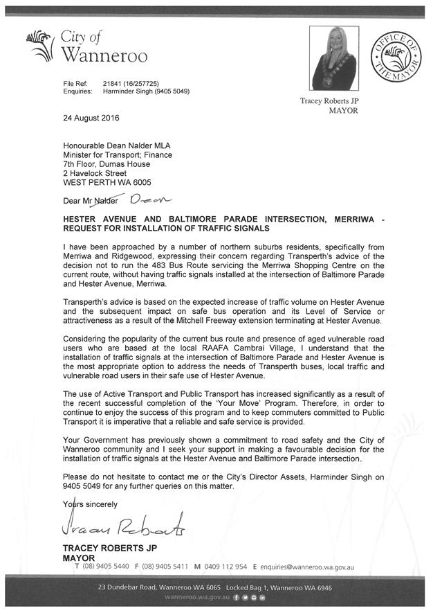
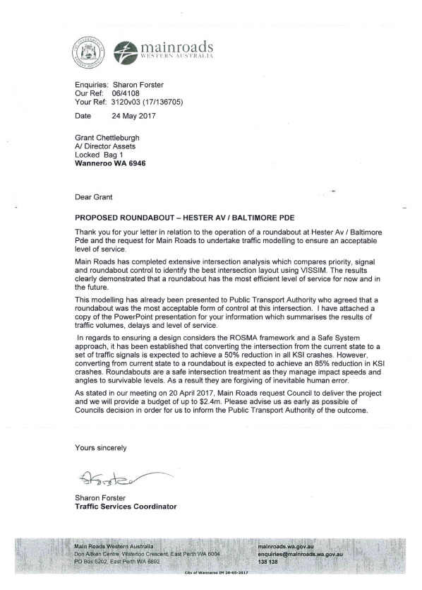
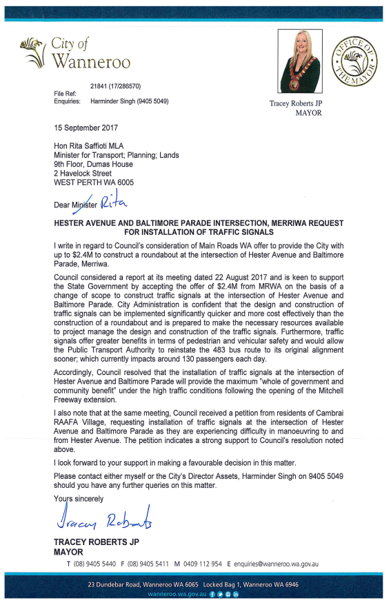
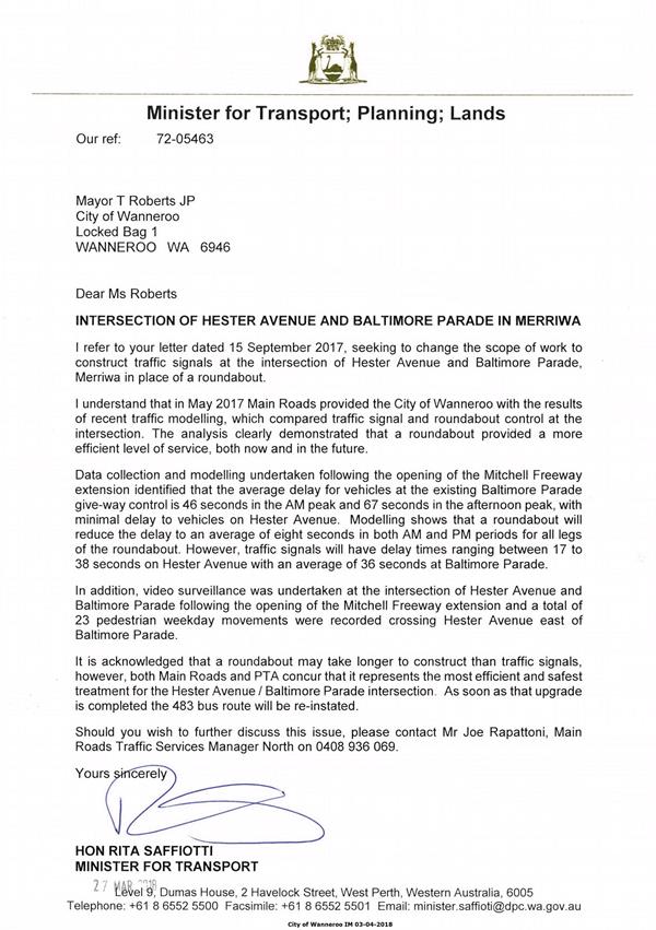
AS01-07/18 Hester Avenue and Baltimore Parade, Merriwa - Intersection Upgrade
AS02-07/18 State and Australian Government Black Spot Programs 2019/20
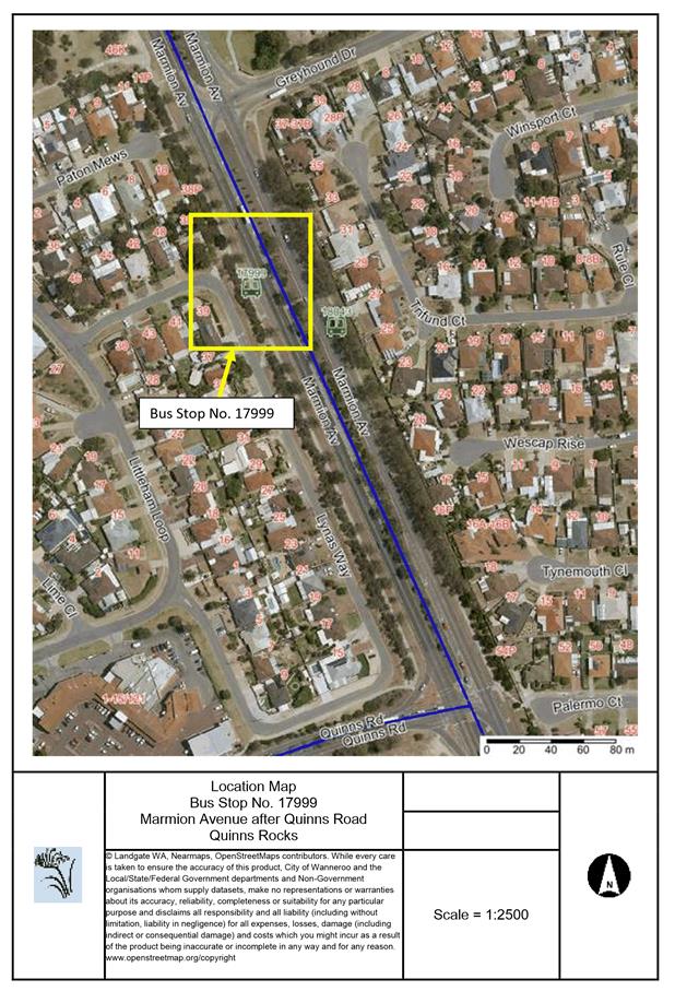
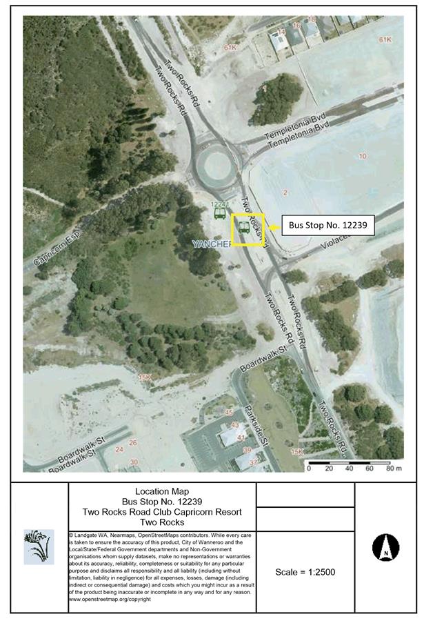
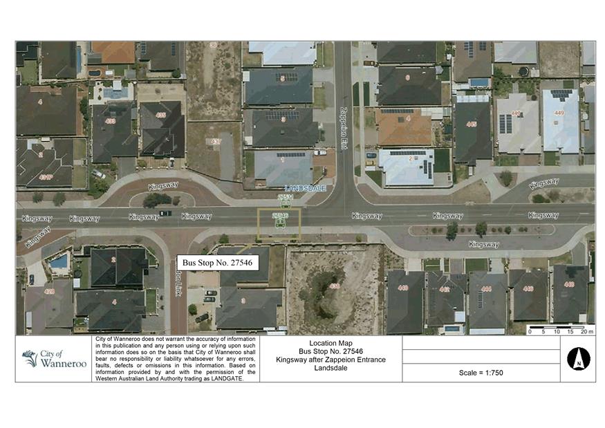
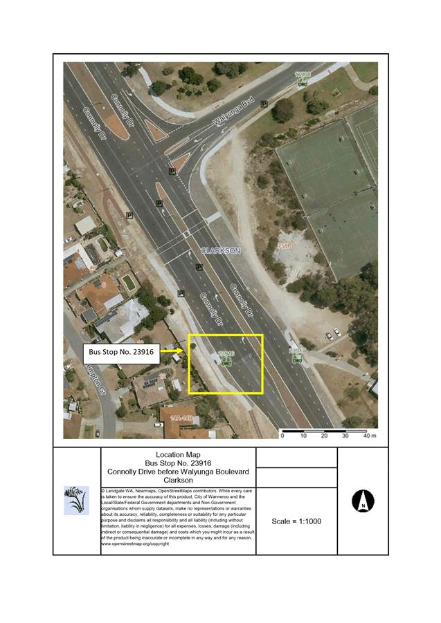
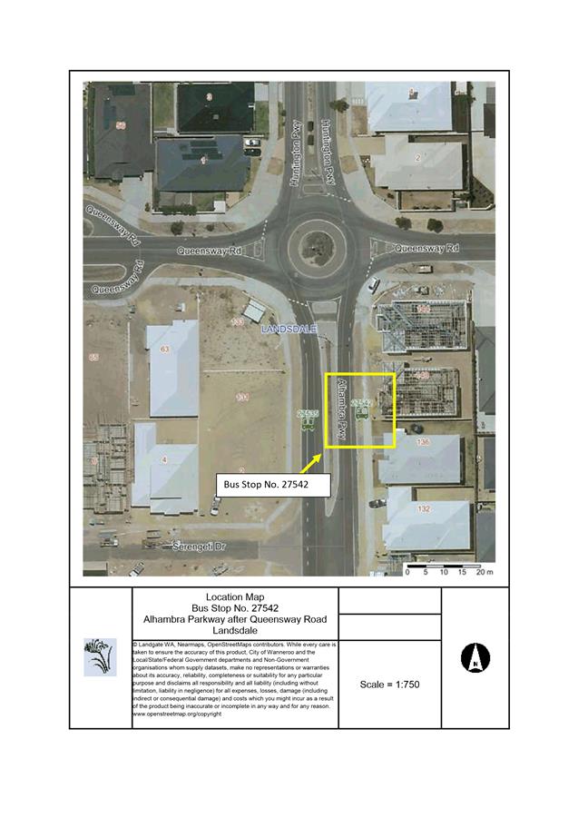
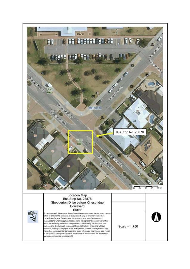
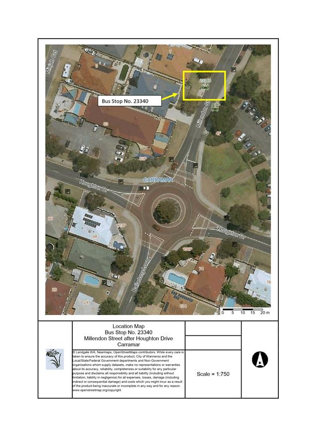
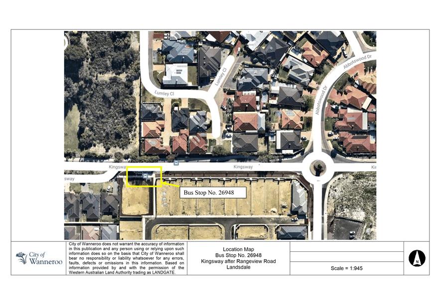
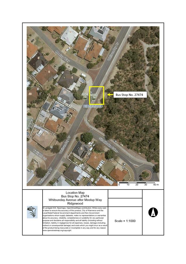
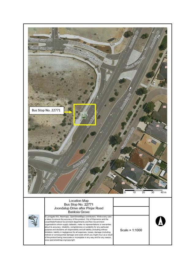
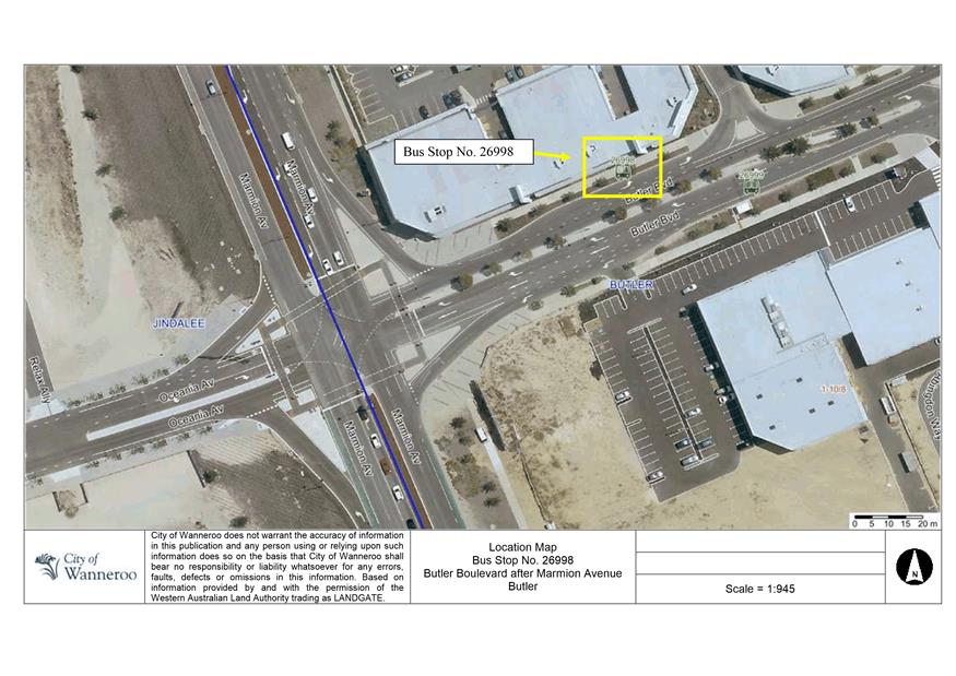
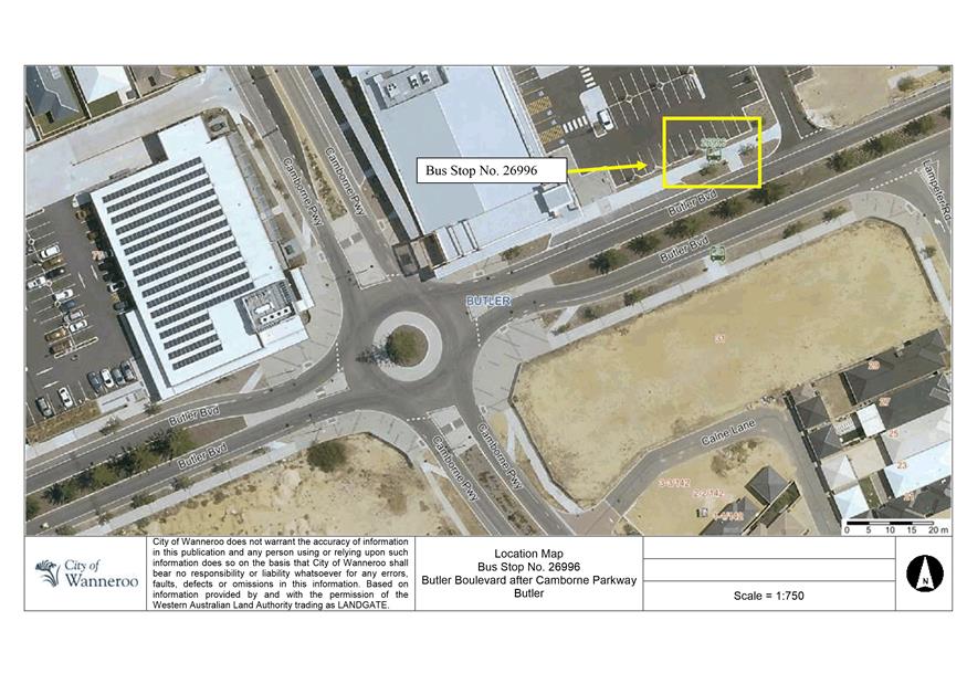
AS03-07/18 Bus Shelter Installation Program 2018/19
CP01-07/18 Wanneroo RSL Sub-Branch Memorial Plaques Request - Memorial Park, Wanneroo
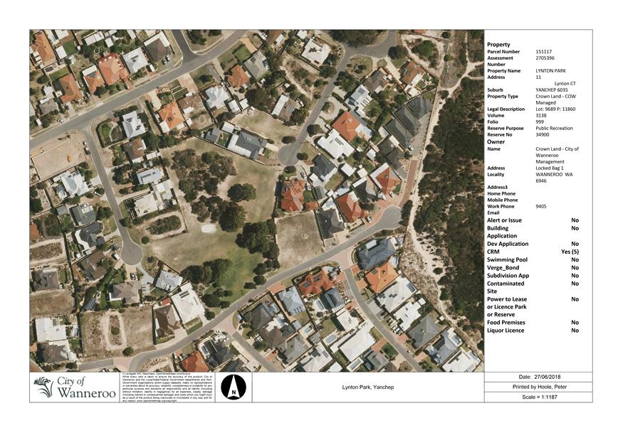
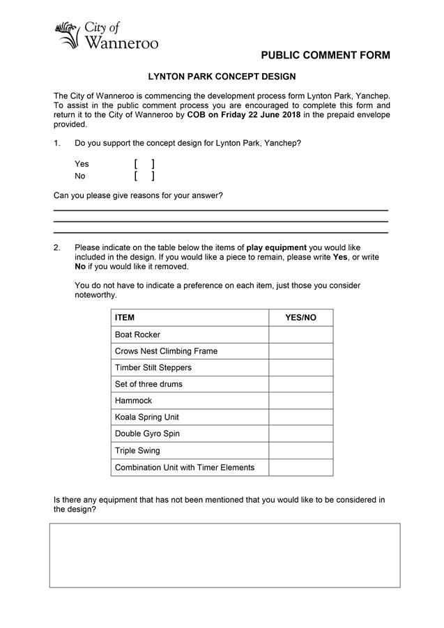
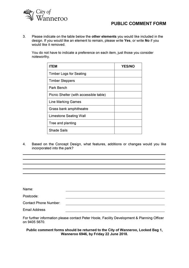
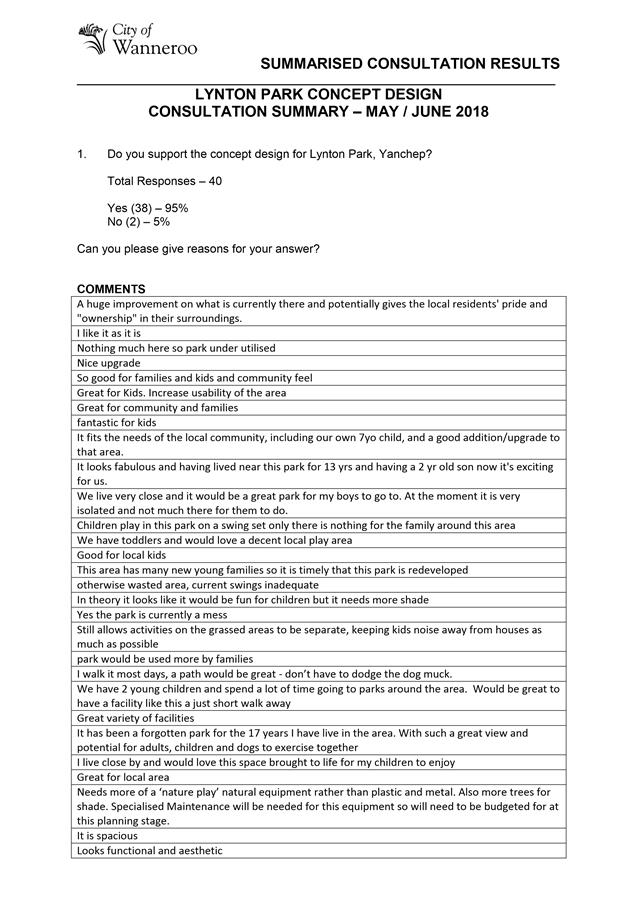
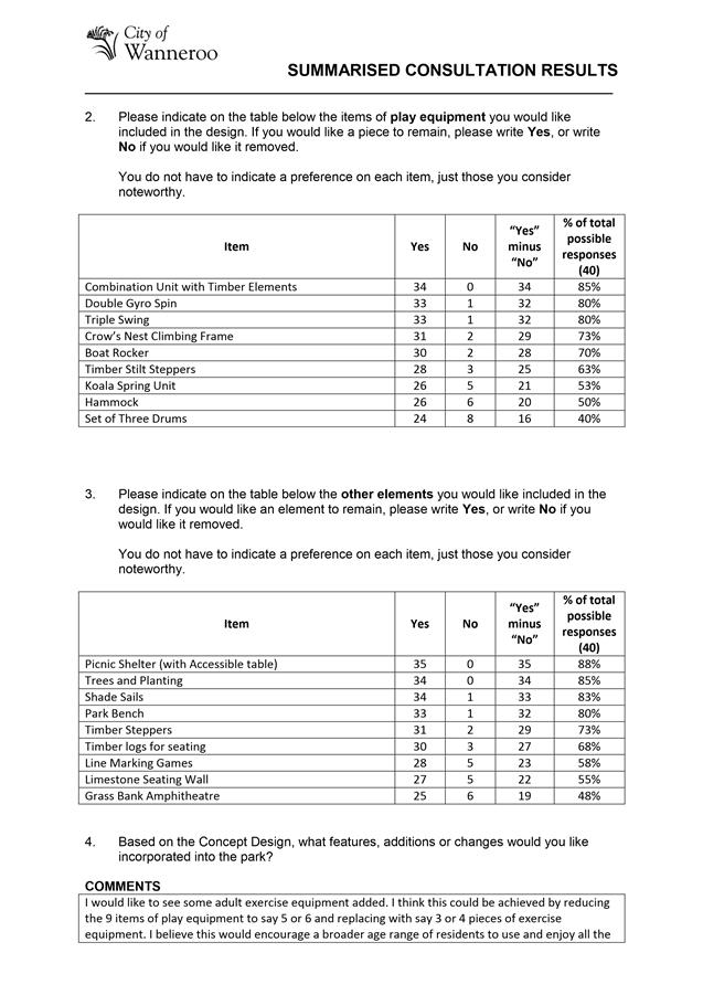
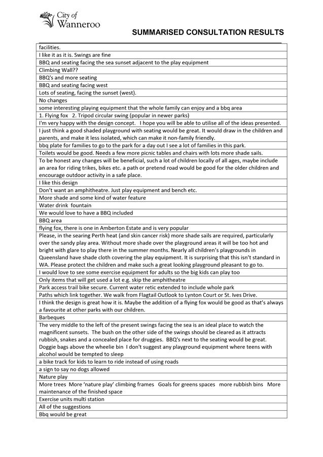
CP02-07/18 Lynton Park Concept Design
CP03-07/18 Draft Community Shed Policy
Corporate Strategy & Performance
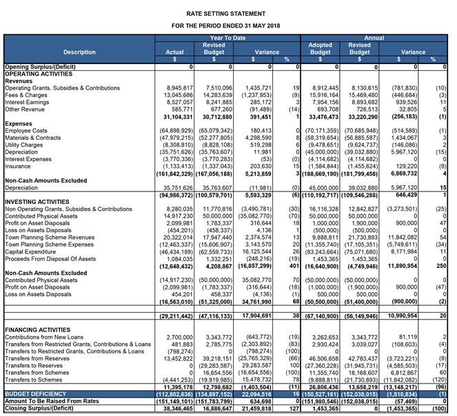
CS01-07/18 Financial Activity Statement for the Period Ended 31 May 2018
CS02-07/18 Warrant of Payments for the Period to 30 June 2018
CS03-07/18 Donations to be Considered by Council - July 2018
CE02-07/18 Amendment to Review Dates for Council Policies - July 2018
CR01-07/18 Marmion Avenue Duplication
Item 12____ Date of Next Meeting
Agenda
Good evening Councillors, staff, ladies and gentlemen, we wish to acknowledge the traditional custodians of the land we are meeting on, the Whadjuk people. We would like to pay respect to the Elders of the Nyoongar nation, past and present, who have walked and cared for the land and we acknowledge and respect their continuing culture and the contributions made to the life of this city and this region and I invite you to bow your head in prayer:
Lord, We ask for your blessing upon our City, our community and our Council. Guide us in our decision making to act fairly, without fear or favour and with compassion, integrity and honesty. May we show true leadership, be inclusive of all, and guide the City of Wanneroo to a prosperous future that all may share. We ask this in your name. Amen
Item 2 Apologies and Leave of Absence
Item 4 Confirmation of Minutes
That the minutes of Ordinary Council Meeting held on 26 June 2018 be confirmed.
Item 5 Announcements by the Mayor without Discussion
Item 6 Questions from Elected Members
Declarations of Interest by Elected Members, including the nature and extent of the interest. Declaration of Interest forms to be completed and handed to the Chief Executive Officer.
Strategic Land Use Planning & Environment
File Ref: 34620 – 18/126824
Responsible Officer: A/Director Planning & Sustainability
Disclosure of Interest: Nil
Attachments: 1
Issue
To consider draft Local Planning Policy 3.3: Fauna Management (LPP 3.3) included as Attachment 1.
Background
As a result of the development of new residential areas and associated removal of bushland, the City has experienced unsustainable kangaroo populations being displaced into residential areas, golf courses, and development sites in Yanchep, particularly around the St Andrews Estate.
Remaining areas of remnant vegetation are unable to adequately accommodate displaced kangaroo and fauna populations. This has adverse effects on the health of displaced fauna and in some areas is distressing to the local community.
These issues have highlighted the need for a policy that clearly outlines the responsibility of developers to effectively manage fauna through the development process and prevents ‘directional clearing’ where fauna is herded onto adjacent land holdings through land clearing, as the default fauna management approach.
In response to these issues, Administration has prepared Draft LPP 3.3 to provide guidance to developers and land owners on the effective management of fauna on land to be cleared for approved development.
Detail
Draft LPP 3.3 provides guidance to developers on the effective management of ‘macro-fauna’ (primarily kangaroos and emus) and applies to all land holdings being transformed from ‘uncleared/intact’ natural habitat into development sites.
Part 1 of the Policy outlines the fundamental principles of fauna management to be adhered to by developers and landowners and to be considered prior to, and during land clearing operations. The principles provide clarity around the responsibility of the landowner (not the community, the City, or the Department of Biodiversity Conservation and Attractions) to ensure the humane containment and management of fauna.
In addition, draft LPP 3.3 confirms that ‘directional clearing’ is generally not supported as a first option for the management of macro-fauna, with the preferred approach being the proactive removal of macro-fauna from development sites via other means such as trapping and relocation. All costs associated with fauna management over future or existing development sites remains the responsibility of the landowner.
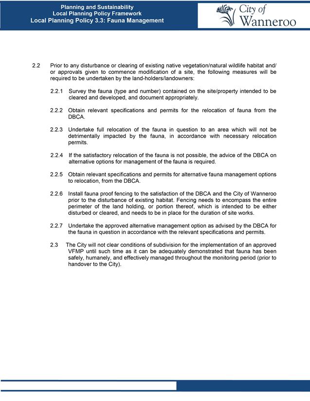
Part 2 of the Policy provides specific guidance on how fauna is to be managed on development sites where vegetation removal or significant disturbance to vegetation is expected. Prior to any disturbance or clearing of existing native vegetation/natural wildlife habitat, the landowner will be required to prepare a Vegetation and Fauna Management Plan that addresses the key principles outlined in Part 1 of the Policy, and prescribes specific kangaroo management measures, which may include:
· Conducting site specific surveys;
· Considering fauna management options such as the relocation of fauna in the first instance, or alternative management options approved by the DBCA if satisfactory relocation is not possible;
· Containment of the development site through adequate fencing (such as, but not necessarily limited to a minimum 1.8m high chain mesh fence with steel posts, strainer wire at top and bottom);
· Obtaining relevant permits through the DBCA; and
· Compliance with approved Vegetation and Fauna Management Plans.
The actual type of fencing employed on a particular site will be identified in the Fauna Management Plan and required to be approved by the DBCA as “fit for purpose”. The fencing will need to take into account topography and soil conditions to ensure macro-fauna are contained.
Draft LPP 3.3 does not propose additional requirements above and beyond existing planning and development processes. Rather, the draft Policy aims to change the timing and priority of fauna management measures by requiring land developers to manage the humane removal of fauna from future development sites prior to the disturbance of fauna habitat.
Consultation
Through the preparation of draft LPP 3.3, Administration engaged with developers active in the City to brief them on the issues experienced in Yanchep and seek input into the development of draft LPP 3.3. Developers acknowledged the need for a consistent approach to the management of macro-fauna and requested that the Policy allow for some flexibility in relation to the timing and nature of fauna management measures implemented for each development site. This feedback has been considered and incorporated into draft LPP 3.3.
Draft LPP 3.3 was presented to the Environmental Advisory Committee (EAC) on 6 February 2018, where the Committee requested that the draft Policy be clearer on fencing requirements and compliance with approved management plans. Draft LPP 3.3 was subsequently updated and presented again to the EAC on 16 May 2018 where the Committee recommended that the draft Policy is presented to Council for approval to advertise.
Clause 4 (2) of the deemed provisions of DPS 2 requires a draft Local Planning Policy to be advertised for a minimum of 21 days. However, typically the City advertises Local Planning Policies for 42 days to allow sufficient time for comments to be made. If agreed by Council and in accordance with Clause 4 (1), draft LPP 3.3 will need to be advertised for public comment for a period of 42 days in the following manner:
1. Advertisement in a local newspaper;
2. Display notice of the proposal in Council offices and on the City’s website; and
3. Letters to relevant stakeholders as determined by the Director Planning and Sustainability.
Following the 42 day advertising period, a summary of submissions received and Administration’s responses to those submissions will be included in a report to Council to consider final adoption of draft LPP 3.3.
Comment
Extensive areas of kangaroo habitat have been zoned for urban development and as such will be cleared in due course. If the current approach to managing macro-fauna on development sites is not changed, then this may potentially lead to an exaggeration of the existing problem with unsustainable fauna populations in undeveloped areas of remnant bushland.
This will create an inequitable situation where the responsibility to appropriately manage macro-fauna is deferred to the City or landowners who are yet to develop their land. This will result in greater ongoing relocation costs, and have a negative impact on the community as native animals will continue to be forced into residential areas and onto development sites.
By requiring containment of development sites through the installation of fencing prior to land clearing, LPP 3.3 will ensure that land-holders/landowners are solely responsible for the management of fauna on their property. Containment fencing also serves as a barrier to prevent kangaroos and other large fauna from entering, or re-entering, the property following installation.
Once an area is contained, landowners will need to consider options for fauna management, the default option being relocation of the fauna.
LPP 3.3 offers flexibility for landowners in terms of when and how they contain and manage fauna on their property. The requirement for containment prior to land clearing means that landowners will need to consider fauna management well in advance of a site being developed. This means that developers need to consider the risk of delaying containment which could potentially increase the costs associated with fauna management if left too late, especially if adjacent land holdings have already been contained.
The benefits of this approach to fauna management on development sites include but are not limited to:
· Reduced financial, reputational and social risks to the City;
· Reduced cumulative impact of development on native fauna and vegetation;
· Healthier retained vegetation and conservation reserves due to manageable and sustainable fauna populations; and
· Fewer direct impacts of fauna relocation on the community.
By ensuring that developers manage fauna on land for which they are responsible in a proactive manner, the City can potentially avoid future situations similar to that experienced in Yanchep.
Statutory Compliance
In accordance with Clause 3 (1) of the deemed provisions of DPS 2, Council may resolve to prepare and adopt a local planning policy to apply to any matter related to planning and development of the City. A draft policy must be advertised for public comment for a period of not less than 21 days after which time it is to be reviewed in the context of any submissions received and either adopted with or without modifications or not proceeded with.
Strategic Implications
The proposal aligns with the following objective within the Strategic Community Plan 2017 – 2027:
“3 Environment (Natural)
3.2 Enhanced Environment
3.2.1 Maximise the environmental value of beaches nature reserves and parklands”
Risk Management Considerations
|
Risk Title |
Risk Rating |
|
CO-O22 Environmental Management |
High |
|
Accountability |
Action Planning Option |
|
Director Planning and Sustainability |
Manage |
Ineffective environmental management systems may lead to a lack of environmental awareness, control and possible breach of environmental obligations resulting in financial losses, irreparable damage to the environment and the City's reputation.
Policy Implications
Nil
Financial Implications
Nil
Voting Requirements
Simple Majority
That Council, pursuant to clauses 4(1) and 4(2) of the deemed provisions of the City of Wanneroo District Planning Scheme No.2, ADOPTS the draft Local Planning Policy 3.3: Fauna Management contained in Attachment 1 for the purpose of advertising and ADVERTISES draft Local Planning Policy 3.3: Fauna Management, as contained in Attachment 1, for public comment for a period of 42 days, by way of the following:
1. Advertisement in a local newspaper;
2. Display notice of the proposal in Council offices and on the City’s website; and
3. Letters to relevant stakeholders as determined by the Director, Planning and Sustainability.
Attachments:
|
1⇩. |
Draft Local Planning Policy 3.3 Fauna Management |
18/274376 |
Minuted |
CITY OF WANNEROO Agenda OF Ordinary Council Meeting 24 July, 2018 8
File Ref: 1919 – 18/246908
Responsible Officer: Director Planning and Sustainability
Disclosure of Interest: Nil
Attachments: 1
Issue
To consider a proposed submission on the State Government Green Paper on modernising Western Australia’s planning system.
Background
In late 2017, the Minister for Planning appointed a team to undertake an independent review of the State’s planning system.
The Minister has now released a ‘Green Paper’ prepared by the review team for a public comment period concluding on 20 July 2018. The Department of Planning, Lands and Heritage (DPLH) has agreed to accept a City submission to be lodged immediately after the Council meeting of 24 July 2018.
Following assessment of submissions received on the Green Paper (which is an independent review and does not represent government policy), the State Government will prepare a ‘White Paper’ which will set out its proposed reforms for planning. The White Paper will also be subject to a consultation process, prior to State Government approval and implementation.
Detail
The Green Paper aims to identify ways to make the State’s planning system more effective, streamlined, open and understandable to everyone.
The Green Paper outlines challenges in the planning system, and has been undertaken to respond to concern that the State’s planning system has become overly complex and focusses too much on individual applications for development. According to the Paper, most people only engage with the planning system to react to a development proposal in their neighbourhood, rather than contributing to the future form of their community. Similarly, it states that decision-makers often respond to individual development proposals, rather than setting a vision for an area to which the development industry can respond.
The Green Paper represents a shift from statutory-led (eg: assessment of planning applications) to strategically-led planning (eg: local planning strategy, local planning schemes and structure planning), with more focus on community consultation.
In this regard, the reform encourages early involvement by the community to shape their future and assists landowners to clearly understand what is the vision for their area and what is permitted on their lots. Many of the proposals within the Green Paper give precedence to strategic planning, which establishes a ‘line of sight’ through State and local government strategies to explain how they work together to inform decision-making.
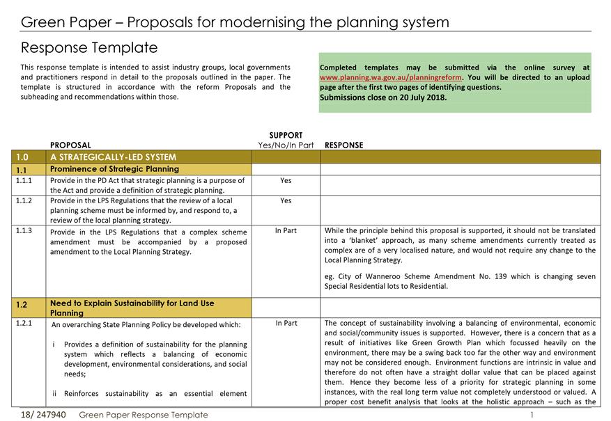
In order to achieve this, the Green Paper proposes five key reform areas:
1. Strategically-led:
Make strategic planning the cornerstone of the planning system.
2. Legible:
Make the planning system easy to access and understand.
3. Transparent:
Open up the planning system and increase community engagement in planning.
4. Efficient:
Make the planning system well-organised and more efficient.
5. Delivery smart growth:
Refocus the planning system to deliver quality urban infill.
For each of the above key reform areas, the Paper makes proposals, with a total of 75 proposals covering all key reform areas being made. These are included in Attachment 1.
Consultation
The State Government has released the Green Paper for a public comment period concluding on 20 July 2018.
Comment
This planning reform initiative is welcomed. As one of the fastest growing local governments in Australia, the City needs an effective planning system to facilitate the population growth and ensure that we grow in a sustainable way.
The fresh emphasis on strategic planning is supported, so that we can plan with our communities for the future. It is important that we focus on the important strategic issues and how to resolve these, rather than get bogged down by the detail that could easily lose track of what was originally intended. In our fast-paced growth environment, we do not have the luxury of spending time on efforts which may not get us where we want to be in the most effective and sustainable manner. This will enable us to focus our resources on where these could have the most impact.
In some respects, the Green Paper proposals are not ‘ground-breaking’, as many of the principles and emphasis embedded in the proposals are already part of the planning system. However, some of these have been inconsistently applied across State and local government, or has morphed into efforts which have never been intended originally. Most of the proposals which are of a relatively broad nature are generally considered sound, however it will be important to assess them further as the detail on them becomes available.
The Green Paper proposals have been assessed and those proposals that are recommended for comment upon (together with the recommended comments) are included in Attachment 1. This attachment is the submission template that the reform team has requested that submitters use.
Following is a summary of the key issues raised in the proposed submission:
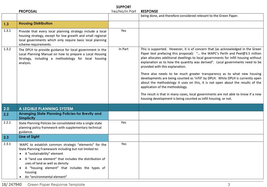
· Sustainability (Proposal 1.2)
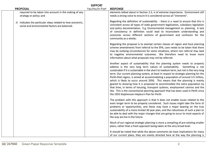
The Green Paper proposes that the principle of sustainability be given more emphasis in the way that planning is done, particularly in terms of a more effective balancing of environmental, social and economic factors.
This is supported, however the matter of timeframes applied to sustainability is also important. Something which may be sustainable in the short to medium term but not in the long term is not sustainable, so our higher level strategic planning actually needs to be more strategic to look further ahead than the 30 year planning horizon currently used for key strategies such as Perth-Peel@3.5 million.
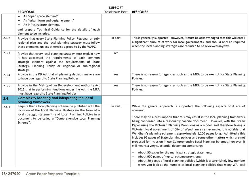
· Form of Local Planning Schemes (Proposal 2.4.1)
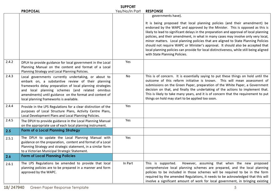
It is proposed that local planning schemes include the ‘local strategic statement’ from the local planning strategy, as well as Local Planning Policies, to form a ‘Comprehensive Local Planning Scheme’. While this is supported, concern is raised regarding the likely delays that may arise through Local Planning Policies, and their amendment, having to be approved by the WAPC and Minister for Planning. Provided they are aligned with State Planning Policies, they should not need such approval.
· Delay of Local Planning Strategies and Schemes until Proposed Frameworks Available (Proposal 2.4.3)
New formats for local planning strategies and local planning schemes are proposed. It is likely to take many years before this reform process is complete, and the proposed new formats are available. It is unreasonable to expect high growth local governments such as the City of Wanneroo, which need to have up-to-date planning instruments, to delay doing these things for an indeterminate period which is likely to be lengthy.
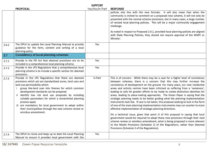
· Standardisation of Zones, Land Uses and Permissibility in Local Planning Schemes (Proposal 2.7.3)
It is proposed that standard zones, land uses and land use permissibility provisions be included in all local planning schemes. While the Planning Regulations currently stipulate what types of zones should be in local planning schemes, they leave it up to each local government to decide what land uses to include in the Zoning Table in the local scheme (including which of those to include from those defined in the Regulations, as well as any additional uses), but in particular, what permissibility designation to apply to each use in each zone. This proposal therefore involves a significant increase in standardisation across local government.
This may make it more difficult to implement strategic planning initiatives that may be aiming to foster greater distinctiveness of places.
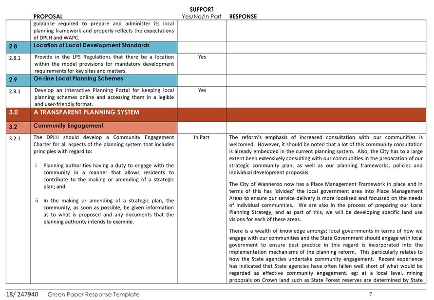
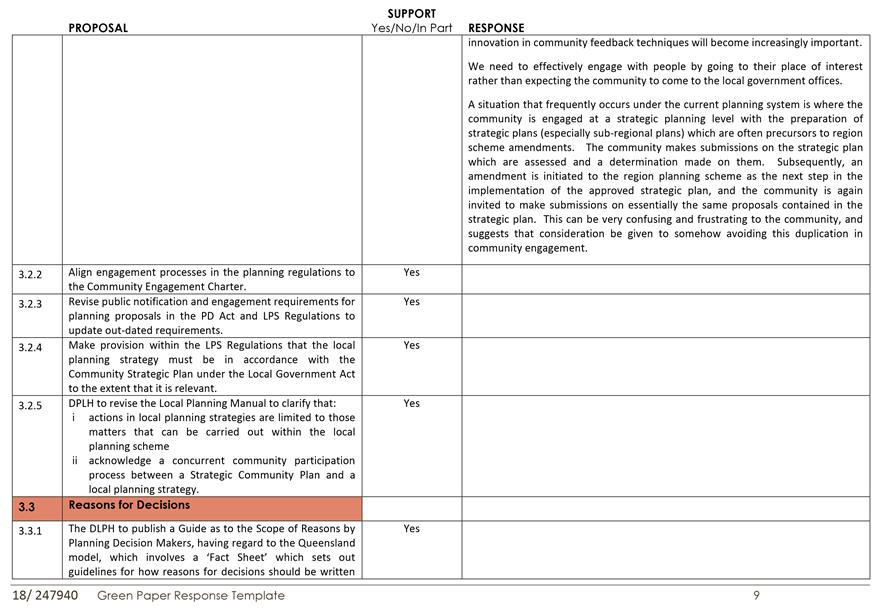
· Development of a ‘Community Engagement Charter’ by DPLH (Proposal 3.2.1)
It is proposed that DPLH prepare a ‘Community Engagement Charter’. The related text in the Green Paper indicates that such a Charter would include ‘the goals of engagement, when to give notice to the community to participate, information to be provided (including the documents available to the planning authority), the methods to be used and the points of contact’.
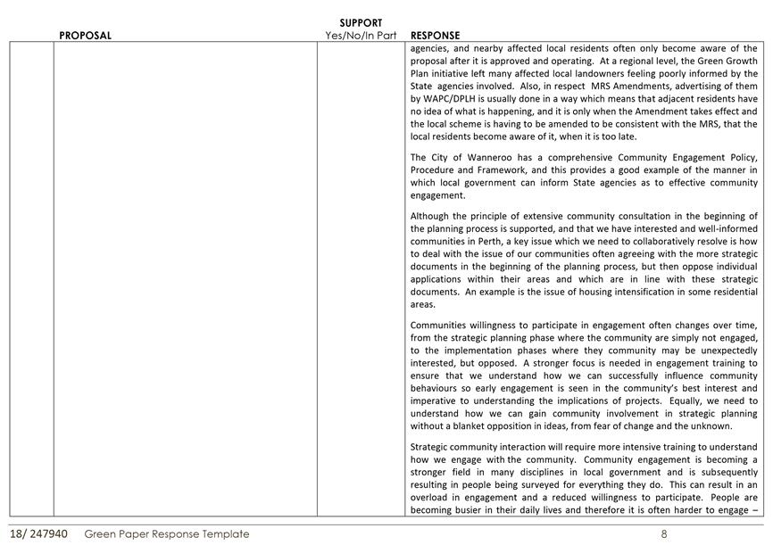
While such a Charter may be of benefit, it needs to be acknowledged that local government, as the level of government closest to local communities, has been engaging with their local communities for many years and have developed much expertise and experience with this. For example, the City has a comprehensive Community Engagement Policy, Procedure and Framework which also does what the Green Paper is referring to. By contrast, State agencies have often performed poorly in respect to community engagement eg: sand mining proposals on Crown land that are determined by State agencies, with affected local residents not becoming aware of it until after the proposals are approved and operating. Local government therefore needs to be closely involved with preparation of such a Charter, and not have something prepared mainly at State level which is then sought to be imposed on local government.
A key feature of any Charter needs to include the principle of the planning agencies ‘going to the people’, rather than always expecting the people to come to them.
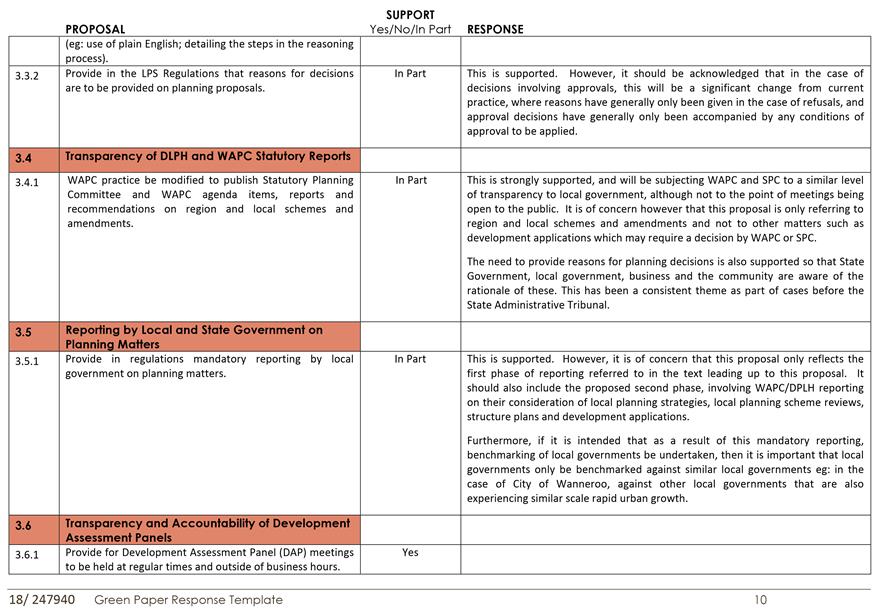
· Greater Transparency (Proposal 3.4)
It is proposed that agenda items of the WAPC and some of its key committees be published. This should be strongly supported, as it will enable everyone to obtain a greater understanding as to the reasoning behind the decision-making at that level.
Similarly, in respect to how the WAPC infill housing targets for local governments are being set, this is something which local governments are not being informed of, let alone engaged on. The Green Paper (Proposal 1.3.2) proposes that local government be properly informed as to how the WAPC is doing this, and this greater transparency is also supported.
· Mandatory Reporting by Local Government on Planning Matters (Proposal 3.5.1)
The Green Paper refers to introducing mandatory reporting on planning matters in two phases:- first phase for local government (eg: on number of development applications determined, and processing times; percentage of development applications determined under delegation) and a second phase for WAPC/DPLH (on their processing of local planning strategies, local planning scheme reviews, structure plans and development applications). However, the actual Green Paper proposal only refers to Phase 1. Given how long the WAPC/DPLH is currently taking to deal with many local planning strategies and schemes reviews and structure plans, it is important that they be subject to mandatory reporting at the same time as local governments.
Furthermore, if it is intended that as a result of this mandatory reporting, benchmarking of local governments be undertaken, then it is important that local governments only be benchmarked against similar local governments eg: in the case of City of Wanneroo, against other local governments that are also experiencing similar scale rapid urban growth.
· Local Government Accreditation and Delegation (Proposals 4.1.2 and 4.1.3)
It is proposed that an accreditation system be introduced to enable the WAPC to make further delegations on planning matters, including determining of infill subdivision, and subdivision in accordance with approved local structure plans. The accreditation system would require local governments to have up-to-date local planning strategies and schemes, and appropriately qualified planning officers and appropriate delegations to those officers. This is supported, subject to local governments being able to recover the costs involved through adequate charging arrangements.
It should be noted that the proposed requirements for accreditation do not involve any impinging by WAPC on local government planning powers, as local governments are already required to have up-to-date local planning schemes and strategies anyway. The proposed delegations for determining certain types of subdivision applications would involve an increase in local government planning powers and will be quite significant, as this will probably be the first time in the State’s history that local governments will be determining freehold subdivision applications.
However, delegation should go beyond just determining some types of subdivision applications, and should include areas where there is currently unnecessary and wasteful duplication of processing occurring between local government and WAPC/DPLH eg: where proposed structure plans are consistent with State Planning Policies and Local Planning Policies, then their determination should be delegated to local government. This will considerably free up WAPC/DPLH resources to be able to redirect to matters which really do require their attention.
· Structure Plans to Have ‘Force and Effect’ of the Scheme (Proposal 4.2.8)
This is to be done through an amendment of the Planning and Development Act, and will return the status of structure plans to what it was prior to the Planning Regulations of 2015 making them of only ‘due regard’ status. This limited status has presented many practical problems for local government so its return to ‘force and effect of scheme’ status is strongly supported eg: some applicants have argued that uses which may be ‘X’ (prohibited) uses in a particular area under a structure plan, should still be approved because the City only has to have due regard for the structure plan.
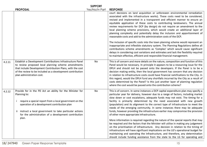
· Development Contribution Plans (DCP) (Proposals 4.2.10, 4.2.11 and 4.2.12)
- 4.2.10: This involves cost schedules for DCP being included in a local planning scheme. This is strongly opposed. The inclusion of specific costs into the town planning scheme would represent an inappropriate and inflexible statutory system. The Planning Regulations define all contributions scheme amendments as ‘Complex’ which would cause significant delays in considering cost variations and estimates and lack the flexibility required to maintain effective, efficient and responsible financial management.
- 4.2.11: This involves a DCP Panel being established to review scheme amendments that involve DCPs. This is of concern and more details on the nature, composition and function of this Panel would be necessary. In principle it appears to be a resourcing issue for the DPLH and should not be passed onto the developers. If the Panel is to be a decision making entity, then the local government has concern that any decision in relation to infrastructure costs could have financial ramifications to the City.
- 4.2.12: This involves the Minister for Planning being able to require a ‘special report’ from a local government on the operation of a DCP, and to be able to instruct a local government to take particular actions for the administration of a DCP.
This is of concern. More information is required regarding the nature of the special reports that may be required and the factors that the Minister will utilise in making any judgement on the prioritisation of infrastructure. Any decision in relation to the timing of infrastructure will have significant implications on the LG’s operational budget for maintaining and operating the infrastructure, and therefore, any determination should include funding assistance from the state to the LG for operating and maintaining infrastructure provided earlier than otherwise necessary.
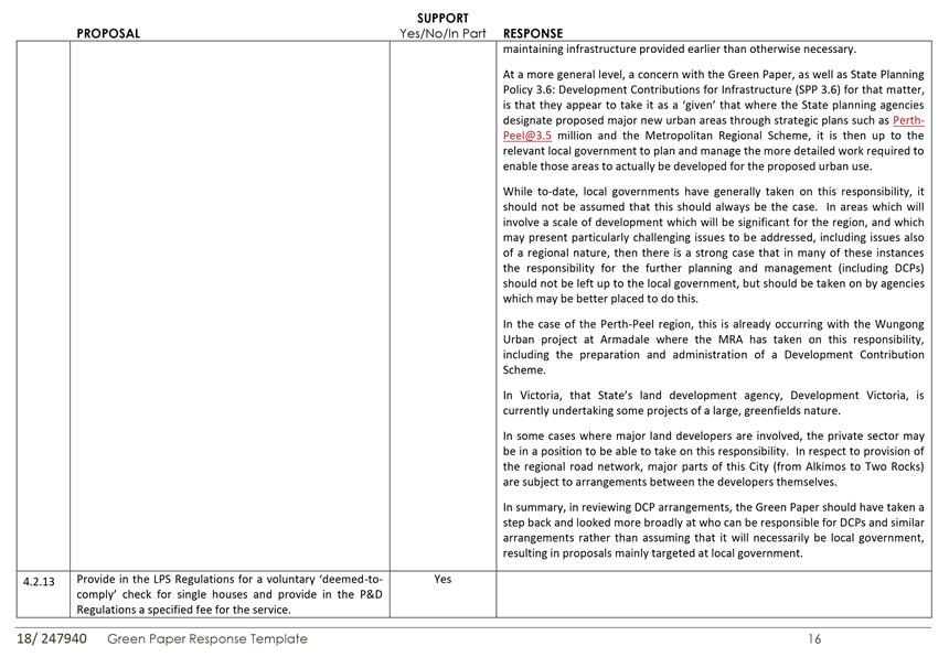
At a more general level, a concern is that the Green Paper has taken it as a ‘given’ that responsibility for preparation and administration of DCPs rests with local government. There are situations where it may be more appropriate that this responsibility should lie with the State Government (eg: through the Metropolitan Redevelopment Authority – MRA), especially for projects which may be of a regionally significant scale, and where issues may need to be addressed which are of a regional nature.
The Wungong Urban project in City of Armadale is a current example where the MRA has taken on this responsibility, including the preparation and administration of a Development Contribution Scheme.
In Victoria, the State development agency, Development Victoria, is also involved in greenfields urban development projects.
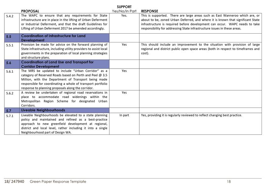
· State Infrastructure Requirements to be Met Prior to Lifting of Urban Deferment (Proposal 5.4.2)
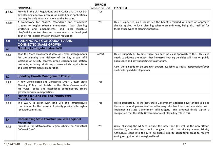
This will be important for the future East Wanneroo urban area when it is known that there are some significant State infrastructure issues to be addressed, particularly in respect to connection of the area to the Alkimos Waste Water Treatment Plant. This is therefore supported by Administration.
· Liveable Neighbourhoods to be Elevated to Status of State Planning Policy (Proposal 45.7.1)
This is supported, provided Liveable Neighbourhoods is regularly reviewed to reflect changing best practice.
It is also recommended that the City’s submission include a comment upon the matter of the proposed implementation of the reform (which is not covered in the submission template). In this regard, local government requires clear guidance on how implementation is proposed to occur, in particular the time implications for the preparation of local government planning instruments. Many of the formats of the documents proposed by the Reform have not been worked out yet but local governments have to continue to prepare and finalise planning instruments such as local planning strategies and local planning schemes. Administration consider that the City cannot afford to ‘wait’ for the work to be completed at State Government level before finalising our documents, and some assistance is required in this regard.
Statutory Compliance
Nil
Strategic Implications
The proposal aligns with the following objective within the Strategic Community Plan 2017 – 2027:
“4 Civic Leadership
4.1 Working with Others
4.1.3 Advocate and collaborate for the benefit of the City”
Risk Management Considerations
|
Risk Title |
Risk Rating |
|
ST-504 Integrated Infrastructure and Utility Planning |
Moderate |
|
Accountability |
Action Planning Option |
|
Director Planning and Sustainability Director Assets |
Manage |
“The above risk/s relating to the issue contained within this report have been identified and considered within the City’s Strategic risk register. Action plans have been developed to manage this risk to support existing management systems.”
Policy Implications
Nil
Financial Implications
Proposed 4.1.2 of the Green Paper involves provision for a local government accreditation process. The intent of this is that accredited local governments would receive delegation from the Western Australian Planning Commission (WAPC) to determine small infill subdivision, and subdivision which is in accordance with an approved local structure plan.
If the proposal is implemented and this City became accredited and WAPC delegation in respect to the above matters occurs, this may mean additional resources having to be put in place to enable those extra functions to be undertaken. However, the cost of this should be recoverable through planning fees.
Voting Requirements
Simple Majority
That Council:-
1. ENDORSES the proposed submission on the Green Paper on Modernising Western Australia’s Planning System included in Attachment 1.
2. INCLUDES as part of this submission, comments that:
a) In respect to implementation of the Green Paper proposals, local government requires clear guidance on how implementation is to occur, in particular the time implications for the preparation of local government planning instruments such as local planning strategies and local planning schemes;
b) Development Contribution Plans should not necessarily be assumed to always be the responsibility of local government, and that where projects are of regional significance and involve issues of a regional nature, then alternative approaches may be more appropriate, which may involve greater State Government responsibility, or potential private sector involvement.
Attachments:
|
1⇩. |
City Submission on Green Paper (final) |
18/262887 |
Minuted |
CITY OF WANNEROO Agenda OF Ordinary Council Meeting 24 July, 2018 33
PS03-07/18 Close of Advertising - Annual Review of the Yanchep-Two Rocks Development Contribution Plan Cost Estimates
File Ref: 23156V02 – 18/233857
Responsible Officer: Director Planning and Sustainability
Disclosure of Interest: Nil
Attachments: 1
Issue
To consider the annual review of cost estimates for the Yanchep-Two Rocks Development Contribution Plan in accordance with the provisions of Schedules 14 and 15 of District Planning Scheme No. 2 (DPS No. 2).
Background
Amendment No. 122 to District Planning Scheme No. 2 was gazetted in September 2014 and introduced the Developer Contribution Plan (DCP) provisions into DPS No. 2. The Yanchep-Two Rocks Development Contribution Plan and Cost Apportionment Schedule were subsequently adopted by Council in April 2015 (PD07-04/15).
The DCP is subject to an annual review requirement to ensure that the cost contribution amount is correctly set to ensure the collection of sufficient funds to cover the cost of approved infrastructure items over the life of the DCP
The DCP identifies various community facilities and provides estimates on the total cost, estimated contributions and the timing for the delivery of infrastructure within the Yanchep-Two Rocks area. The infrastructure costs include planning, design, project management costs, site servicing, construction costs and land acquisition costs associated with the following infrastructure;
· Yanchep Surf Life Saving Club
· Yanchep District Open Space
· Capricorn Coastal Node Facilities
In accordance with Schedule 15 of DPS No. 2, the DCP has an operation period of 10 years and during this time period the City is required to review the various elements of the DCP at one and five year intervals as per the following;
Annually
· DCP Cost Estimates.
· DCP Cost Indexation.
· Dwelling Estimates.
· Cost per Dwelling.
5-yearly
· Community Facility Plan (CFP) Assumptions and Recommendations
· Full DCP Review.
At the meeting of Council on 1 May 2018 (PS02-05/18), Council considered the 2018 revised cost estimates for the Yanchep-Two Rocks DCP and resolved (amongst other things);
“8. Pursuant to Clause 11.6 of Schedule 17 of District Planning Scheme No. 2 NOTIFIES affected landowners of the proposed cost increase and INVITES comment in writing from those landowners for a period of 28 days”
Detail
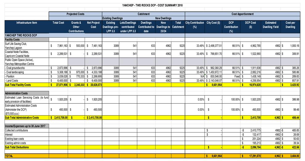
A detailed breakdown of cost estimates, dwelling estimates, administration cost and the associated cost per dwelling is defined in Attachment 1. A summary of the revised cost estimates for each facility is detailed below
|
Facility |
2016/17 Cost Estimate |
2017/18 Cost Estimate |
Difference (+/-) |
|
Yanchep Surf Life Saving Club |
$6,833,289 |
$7,961,163 |
$1,127,874 |
|
Yanchep District Open Space |
|
|
|
|
- Land |
$6,400,000 |
$6,400,000 |
- |
|
- Oval groundworks |
$2,661,150 |
$2,873,996 |
$212,846 |
|
- Oval landscaping |
$5,801,243 |
$5,308,188 |
- $493,055 |
|
- Pavilion |
$3,400,000 |
$3,039,028 |
- $360,972 |
|
Capricorn Coastal Node Facilities |
$2,233,689 |
$2,289,531 |
$55,842 |
|
TOTAL |
$27,329,371 |
$27,871,906 |
$542,535 |
Yanchep Surf Life Saving Club
The increase in costs of this facility ($1,127,874) was reported to Council as part of the ‘retendering’ report on 7 March 2017 (AS01-03/17) and again on 1 May 2018 as part of the report requesting advertising approval for this item (PS02-05/18).
The construction of the Yanchep Surf Life Saving Club has now been completed and the facility was officially opened on 11 March 2018. The revised costs for this facility are largely based on actual costs, however there are remaining construction costs yet to be determined by the City’s Project Managers. These final costs could impact on the overall cost of this facility. Any remaining variations should be made available by the Project Managers later this year and will be included into the next available review process.
Yanchep District Open Space
The development of the playing fields, surrounding landscaping, carparks, multipurpose courts and pavilion are now predominately complete and the facility was officially opened on 24 March 2018. The remaining costs are yet to be released by the City’s Project Managers, and therefore, the revised costs consist of estimated and actual costs. These final costs could impact on the overall cost of this facility. Any remaining variations should be made available by the Project Managers later this year and will be included into the next available review process.
Land Value - The 2016/17 estimate of costs adopted a value of $49.98/sqm or $6.4 million. A revised land valuation was obtained in December 2017 and suggests a similar land value of $50.00/sqm ($6.402 million).
Pavilion - The DCP portion of costs for the pavilion was capped at $1,438,149 following landowners’ concerns that the scope had increased from what was previously agreed. The total estimated cost of $3,039,028 includes a grant of $770,333 with the balance of funds being met by from municipal (currently $830,546). The final costs for the pavilion are yet to be released by the City’s Project Managers, and therefore, the revised costs consist of estimated and actual costs. These final costs could impact on the overall cost of this facility. Any remaining variations should be made available by the Project Managers later this year and will be included into the next available review process.
Oval Groundworks/Landscaping - The final costs for the groundworks and landscaping of the POS are yet to be released by the City’s Project Managers, and therefore, the revised costs consist of estimated and actual costs. The current estimate totals $8,182,184 for these works. These final costs could impact on the overall cost of this facility. Any remaining variations should be made available by the Project Managers later this year and will be included into the next available review process.
Capricorn Coastal Node Facilities
The coastal node facility is scheduled in the DCP for construction in 2021/22. Since the last annual review, Capricorn Village Joint Venture (CJVJ) has developed detailed design drawings for the coastal note activity area and lodged an application for planning approval to the City. In May 2018, the City recommended support for the development (DA2017/1021) to the Western Australian Planning Commission (WAPC). Approval by the WAPC is awaiting resolution of issues associated with the Foreshore Management Plan (FMP) for this area, however it is anticipated that approval will be granted in the coming months. Upon approval by the WAPC, City officers will liaise with the landowners to establish the extent and timing for funding of these works by the DCP, where consideration will be given to the scope of works, compared to the original scope of works in the DCP. Any ‘scope creep’ of costs associated with the proposed works (beyond the original scope) may require funding by the developer. In this regard, to proceed with the review of costs, the City has utilised the cost estimates for the original scope of facilities (not the proposed works), and allowed an indexation of 2.5% on the original cost estimate. The current estimate totals $2,289,531. Further consideration of the costs associated with the proposed works will be made as part of a future DCP review of costs in consultation with the landowners in due course.
Consultation
In accordance with Clause 11.6 of DPS No. 2 - Where the review of estimated costs recommends those costs be increased pursuant to clause 11.4(c), then the local government shall in writing invite comment on the proposal from owners for a period of not less than 28 days, prior to making any decision to increase the estimated costs.
In accordance with the above requirement and Item 8 of Council's resolution of 1 May 2018 to initiate advertising (PS02-05/18), formal advertising on the revised costs for the Yanchep Two Rocks DCP occurred between 11 May and 8 June 2018 and included letters to landowners within the Yanchep-Two Rocks Development Contribution Plan area. Additional information was available for viewing at the City of Wanneroo Civic Centre and on the City's website under ‘Your Say' items.
At the close of public advertising one submission was received, which raised the following issues.
|
No. |
Landowner |
Submission issues |
|
1 |
Zebra Properties Holding Pty Ltd (the Reef) |
· Disappointed that there has been 2 increases since 2016 representing an 80% increase in the contribution amount, whilst the value of land in these locations has depreciated substantially since 2007. · The DCP refers to Yanchep and Two Rocks, however there is no evidence of money being spent in the Two Rocks area. The work done in Yanchep is respected (Surf Club and District Open Space) but of little benefit to the residents of Two Rocks. |
Refer to the comments section of this report for Administrations response to the issues raised.
Comment
Clause 11.6 of DPS No. 2 specifies - Where the review of estimated costs recommends those costs be increased pursuant to clause 11.4(c), then the local government shall in writing invite comment on the proposal from owners for a period of not less than 28 days, prior to making any decision to increase the estimated costs.
The 28 day consultation period closed on 8 June 2018, with only one submission being received. In this regard, consideration and a determination on the submission must be made within 90 days of close of advertising. Clause 11.7 of Scheduled 17 of DPS 2 specifies that - The local government shall ‘consider’ any submissions received and within 90 days of the closing date for submissions decide whether the estimated costs are to be maintained or increased, and to notify landowners of Council's decision.
The following reflects the salient issues that were raised in the submission by the landowner and a response by Administration.
“There has been two increases since 2016 representing an 80% increase in the contribution amount, whilst the value of land in these locations has depreciated substantially since 2007”.
The original contribution rate was applied through an interim arrangement based on the provisions of Local Planning Policy 3.3 and was $1,750. In April 2015, Council first adopted the DCP contribution rate of $2,070 and subsequently increased the rate to $2,780 in November 2017 as part of the annual review of costs. The proposed revision of costs for 2018 results in a further increase in the contribution rate to $3,485. The increase in the contribution rates is primarily a consequence of;
· The DCP’s 10 year operating period, and
· Lot creation not achieving the estimated lot yield projections that were originally provided by the landowners.
It should be noted that, the significant increases in the contribution costs are not a direct result of any significant increases to the overall cost of the facilities, which has remained fairly consistent at around $27 million dollars.
At the meeting of Council on 1 May 2018, Council considered the issue of increasing contribution rates (and its effect on land affordability) and resolved to initiate Amendment 166 to District Planning Scheme No. 2 to extend the operating period of the DCP from 10 years to 16 years.
Administration also recommended the use of ID Forecast projections, which represents a more realistic lot yield projection that better aligns with actual lot creation within the Yanchep Two Rocks DCP. The amendment recently received approval from the Western Australian Planning Commission pursuant to regulation 37(4) of then Planning and Development (Local Planning Schemes) Regulations 2015 to advertise the proposed amendment as a ‘Complex’ amendment, which is required to be advertised for a period of 90 days. The amendment is currently being advertised and the closing date for submissions is 20 August 2018.
Should Amendment 166 be approved, the extended operating period of 16 years will enable the original lot yield estimates to be achieved (e.g. approximately 10,000 lots), thereby reducing the per lot contribution rate proposed in this review (approximately 9,000 lots). Current estimates indicate that extending the operating period and using more realistic lot projects (ID Forecast) reduces the contribution rate from $3,485 (2018 – DCP Review) to $3,175 (subject to finalisation of Amendment 166 later this year).
“The DCP refers to Yanchep and Two Rocks, however there is no evidence of money being spent in the Two Rocks area. The work done in Yanchep is respected (Surf Club and District Open Space) but of little benefit to the residents of Two Rocks”.
The City of Wanneroo Northern Coastal Growth Corridor - Community Facilities Plan (CFP) 2012 identifies a range of future community facilities across both Yanchep and Two Rocks. As population growth increases, additional DCP’s will be prepared to enable the funding of new community infrastructure to meet the needs of the population. Whilst the initial infrastructure has been identified within Yanchep, Two Rocks residents can continue utilising the Surf Club and District Open Space facilities, which are not restricted to the Yanchep residents.
The City will continue to monitor and review the CFP and (in due course) prepare new DCPs to fund future infrastructure, as required. At this time there is not adequate population growth to justify the introduction of a new DCP.
Statutory Compliance
The annual review of the Yanchep Two Rocks Development Cost Estimates has been completed in accordance with Part 11 of Schedule 14 of DPS No. 2, which will bring the DCP into compliance with its annual review requirements.
Strategic Implications
The proposal aligns with the following objective within the Strategic Community Plan 2017 – 2027:
“4 Civic Leadership
4.2 Good Governance
4.2.1 Provide transparent and accountable governance and leadership”
Risk Management Considerations
|
Risk Title |
Risk Rating |
|
ST-G09 Long Term Financial Plan |
Moderate |
|
Accountability |
Action Planning Option |
|
Director Corporate Strategy & Performance |
Manage |
|
Risk Title |
Risk Rating |
|
ST-S23 Stakeholder Relationships |
Moderate |
|
Accountability |
Action Planning Option |
|
CEO |
Manage |
|
Risk Title |
Risk Rating |
|
CO - O17 Financial Management |
Moderate |
|
Accountability |
Action Planning Option |
|
Director Corporate Strategy & Performance |
Manage |
The above risks relating to the issue contained within this report have been identified and considered within the City’s Strategic and Corporate Risk Registers. The annual review of the DCP assists in addressing the impacts of the strategic risk relating to Long Term Financial Planning (LTFP) as it ensures that appropriate budget monitoring, timing and provisions are considered. The strategic risk relating to Stakeholder Relationships applies as a key element in the DCP review process to maintain effective engagement with relevant stakeholders. In addition, the Corporate Risk relating to Financial Management would apply as awareness of financial policies and financial management at unit level will be maintained to promote accountability by business owners and an integrated approach to risk assurance.
Policy Implications
Nil
Financial Implications
The DCP is subject to an annual review process to ensure that the cost contribution amount is correctly set to ensure the collection of sufficient funds to cover the cost of approved infrastructure items over the life of the DCP. The proposed revision of costs for 2018 results in an increase in the contribution rate from $2,780 to $3,485.
The City of Wanneroo has an obligation to meet a portion of the facility costs based on a ratio of existing dwelling/lots to new dwellings/lots created during the operating period of the DCP (currently 10 years as defined by Schedule 15 of DPS No. 2). Due to the declining new lot projections since the start of the DCP in 2014, the City’s apportionment increases from 28.7% to 33.49%. This percentage is variable and is calculated annually as part of the annual review of the Cost Apportionment Schedule (CAS). In this regard, any decrease in projected lot yields will affect the City’s liability towards costs and also result in an increase in the contribution rates for the DCP landowners.
Council considered the issue of declining lot yields at its meeting on 1 May 2018 (PS02-05/18) and resolved to initiate advertising of Amendment 166, which proposes to extend the operating period of the DCP from 10 to 16 years. This amendment (if ultimately approved by the Minister for Planning) will enable adequate time for the original lot yield projections to be achieved, return the City’s apportionment back to approximately 28% and simultaneously enable the sharing of the costs over a greater number of lots (consistent with the original assumptions of the DCP). The Amendment proposal is required to follow the Planning and Development Regulations and is currently being advertised for public comment and does not form part of this (2018) review of costs of the Yanchep Two Rocks DCP. (refer Attachment 1 for cost Allocations).
Voting Requirements
Simple Majority
That Council:-
1. NOTES the submission received on the proposed increase to the Yanchep Two Rocks Development Contribution Plan revised cost elements and ENDORSES Administration’s comments in response to those submissions in the comments section of this report;
2. Pursuant to Clause 11.7(b) of Schedule 14 of District Planning Scheme No. 2 increases the Yanchep Two Rocks Development Contribution Plan cost contribution amount from $2,780 per lot to $3,485 per lot and ADOPTS the revised Cost Apportionment Schedule as contained in Attachment 1; and
3. ADVISES submitters of Council’s decision and INFORMS affected landowners of the revised cost that will apply through the Yanchep-Two Rocks Development Contribution Plan.
4. NOTES that Pursuant to regulation 37(4) of the Planning and Development (Local Planning Schemes) Regulations 2015 (the Regulations) that the Western Australian Planning Commission has recently advised the City that Amendment 166 (extension of operating period) to the City of Wanneroo District Planning Scheme No. 2 is a Complex Amendment and is suitable to be advertised.
Attachments:
|
1⇩. |
Attachment 1 - Revised DCP Cost Estimates (2018) |
18/241222 |
Minuted |
Approval Services
File Ref: 3380-16 – 18/210776
Responsible Officer: Director Planning and Sustainability
Disclosure of Interest: Nil
Attachments: 3
Issue
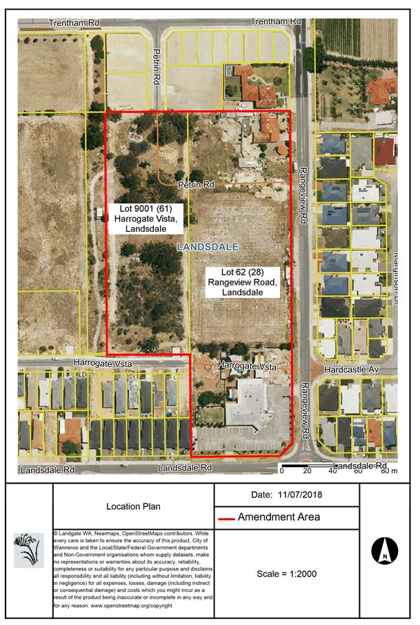
To consider submissions received during public advertising of Amendment No. 16 to the East Wanneroo Cell 5 Approved Structure Plan No. 7 (ASP 7).
|
Applicant |
Jordan Ennis Advisory Town Planning |
|
Owner |
Summerbreeze Developments Pty Ltd & Sam and Steven Filippou |
|
Location |
Lot 9001 (61) Harrogate Vista & Lot 62 (28) Rangeview Road Landsdale |
|
Site Area |
3.4 hectares |
|
MRS Zoning |
Urban |
|
DPS 2 Zoning |
Urban Development |
|
ASP 7 Zoning |
Residential Precinct and Centre Zone |
Background
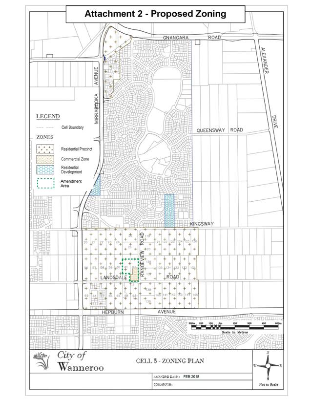
On 25 August 2015, Burgess Design Group on behalf of Summerbreeze Developments Pty Ltd and Sam and Steven Filippou lodged Amendment No. 16 to ASP 7 to rezone portions of Lot 9001 Harrogate Vista and Lot 62 Rangeview Road, Landsdale from Centre Zone to Mixed Use Zone and Residential Precinct with a density coding of R40. Attachment 1 contains the location plan. Following advertising of this amendment proposal, the City received submissions objecting to the proposal.
A revised amendment proposal was submitted for the City’s consideration on 16 February 2018. The details of this amendment are provided in the Detail section below.
On 12 April 2018, the Manager Approval Services forwarded a memorandum to all Elected Members, advising Administration’s intention to re-advertise the amendment proposal as the modified proposal differed from that originally advertised.
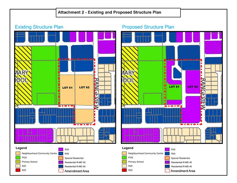
Detail
At present Lots 9001 and 62 are zoned Residential Precinct with a density coding of R40 and Centre in ASP 7. Under the provisions of ASP 7, the Centre Zone is proposed to accommodate a Community Purpose site 5,000m2 in area and a Neighbourhood Centre (South) with a maximum retail net lettable area (NLA) of 1,100m2.
The applicant has proposed to,
· Rezone a portion of the amendment area (9,000m2) as Commercial which can accommodate the retail NLA of 1,100m2;
· Rezone the remainder as Residential Precinct to accommodate the 5,000m2 Community Purpose site as a Public Open Space (POS) adjacent to Trentham Park;
· Nominate coding of areas previously subject to Neighbourhood Community Centre of R30 and R40;
· Include provision for Residential Medium Density (R-MD) codes over R30 and R40 lots; and
· Minor modification to the internal road network, but keeping the same connections to Rangeview Road and Trentham Road.
It is noted that under the provisions of DPS 2 and ASP 7, the Community Purpose site forms part of the 10% POS proposed in Cell 5.
Attachment 2 is the existing and proposed zoning and density coding respectively of the amendment area.
Consultation
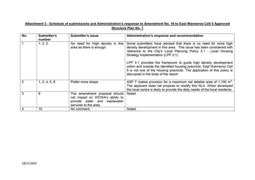
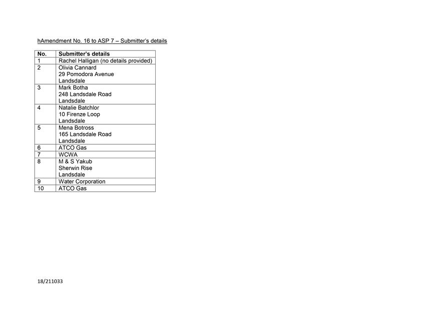
The Amendment was re-advertised for public comment for a period of 28 days by means of an on-site sign, an advertisement in the Wanneroo Times newspaper and on the City’s website and letters to the adjoining and affected landowners. The submission period closed on 22 May 2018. The City received eight submissions including submissions from the Water Corporation of WA (WCWA) and ATCO Gas Australia. WCWA advised that the amendment is minor in nature and therefore should not impact on the Corporation’s ability to provide water and wastewater services to the area. ATCO Gas did not object to the proposal. The remaining six submissions from the residents objected to the proposed density of the development. This issue is discussed in the Comment section below.
A summary of submissions received along with Administration’s responses is attached as Attachment 3 to this report.
Comment
R30 and 40 density development
Some submitters have advised that there is no need for the proposed density of development in this area. This issue has been considered with reference to the City’s Local Planning Policy 3.1 - Local Housing Strategy Implementation (LPP 3.1).
LPP 3.1 provides the framework to guide any increase in housing density within and outside the identified housing precincts. East Wanneroo Cell 5 is not one of the identified housing precincts in LPP 3.1.
In considering applications outside the housing precincts, where the land concerned is subject of an approved structure plan, such applications need to satisfy the criteria listed in Table 3 of this Policy. The amendment has been assessed against the criteria listed in Table 3 as follows:
|
No. |
Criterion |
Policy Application |
Administration’s comments |
|
1. |
Easy Access/Close proximity to Activity Centres. |
This criterion has been applied based on walkable distances as follows:
· R40 between 401 and 800 metres from an edge of Activity Centre excluding local centres |
The subject land is currently zoned Centre in ASP 7 with a retail net lettable area of 1,100m2. The amendment proposes to retain this NLA on a site proposed to be zoned Commercial. When developed, this local centre is likely to provide the daily household needs of the local residents. It is noted that the Western Australian Planning Commission’s (WAPC) State Planning Policy 4.2 does not classify a local centre as an Activity Centre. Yet it is considered appropriate to locate R40 and R30 density within a walkable distance from a local centre. On this basis Administration supports the proposed R30 and R40 developments near the subject local centre. |
|
2 |
Easy Access/Close proximity to public transport with priority towards rail notes and bus interchanges |
This criterion has been applied based on walkable distances as follows:
R60 within 250 metres of a high frequency bus route designated stops. High frequency bus routes are defined as having a minimum of 4 services per hour during peak periods. |
LPP 3.1 does not provide the criterion for locating R30 and R40 developments, it only refers to R60. However, it is noted that the subject area has three bus routes within a 250-metre walkable distance, being 352, 376 and 450.
Route 352 provides access to Whitfords train station and has one service in the morning peak (between 7am and 9am), and five services in the evening peak (between 5pm and 7pm).
Route 376 provides access to Mirrabooka Bus Station and provides 12 services in the morning peak and two services in the evening peak.
Route 450 provides access to Warwick train station and provides four services in the morning peak and four services in the evening peak.
As there is no criterion for R30 and R40 development, it is considered there is sufficient access to public transport for the proposed densities. |
The proposed R30 and R40 densities would provide for a variety of affordable housing within a walkable distance from the local centre and bus routes as noted above. On this basis Administration supports the proposed amendment. In this regard it should be noted that the areas in the vicinity of the amendment area are coded a mixture of R20, R30 and R40 as shown in Attachment 2.
Other Issues
Traffic
The City’s Traffic & Transport (T & T) section has assessed the traffic report and supported the amendment proposal. The amendment proposes a road connection to Rangeview Road. In regard to this road connection, T & T has advised that this connection needs to be designed and constructed in accordance with Public Transport Authority requirements as Rangeview Road is a bus route. These engineering details can be addressed at the subdivision stage.
Community Services
The City’s Community Facilities team has advised that it supports the consolidation of the proposed POS with Trentham Park with a proviso that the POS could be used for community purposes if there was a need in the future. Since this POS is identified as a community purpose site in ASP 7, the City, in the future, can use this site for this purpose, if required. The City is currently undertaking concept designs of Trentham Park and this additional area will allow for the potential future placement of facilities (such as parking and buildings) and meet the intent of the community facility site.
Statutory Compliance
This Structure Plan Amendment has been processed in accordance with the requirements of DPS 2. It is recommended that Amendment No. 16 to the East Wanneroo Cell 5 Approved Structure Plan No. 7 be approved without modifications.
Strategic Implications
The proposal aligns with the following objective within the Strategic Community Plan 2017 – 2027:
“1 Society
1.1 Healthy and Active People
1.1.1 Create opportunities that encourage community wellbeing and active and healthy lifestyles”
Risk Management Considerations
There are no existing Strategic or Corporate risks within the City's existing risk registers which relate to the issues contained in this report.
Policy Implications
This proposal has been assessed under the provisions of the City’s LPP 3.1 and the WAPC’s Liveable Neighbourhoods policy.
Financial Implications
Nil
Voting Requirements
Simple Majority
That Council:-
1. Pursuant to subclause 20(2)(e) of the Deemed Provisions of District Planning Scheme No. 2 RECOMMENDS to the Western Australian Planning Commission that the proposed Amendment No. 16 to East Wanneroo Cell 5 Approved Structure Plan No. 7, as submitted by Ennis Advisory Town Planning on behalf of Summerbreeze Developments Pty Ltd & Sam and Steven Filippou, and included as Attachment 2, be APPROVED WITHOUT MODIFICATION;
2. Pursuant to subclause 20(2) of the Deemed Provisions of District Planning Scheme No. 2 PROVIDES a copy of the report on the proposed amendment to the Western Australian Planning Commission;
3. ENDORSES Administration’s responses to the submissions as provided in Attachment 3; and
4. ADVISES the applicant and submitters of its decision.
Attachments:
|
1⇩. |
Attachment 1 - Location Plan |
18/274378 |
|
|
2⇩. |
Attachment 2 - Amendment 16 to ASP 7 |
18/275623 |
Minuted |
|
3⇩. |
Attachment 3 - Schedule of submissions and Administration Comment |
18/262069 |
Minuted |
CITY OF WANNEROO Agenda OF Ordinary Council Meeting 24 July, 2018 52
PS05-07/18 Consideration of Development Application (DA2017/1410) - Amendment to DA2013/223 and DA2014/275 (Deletion of Vehicle Access Conditions) at Lot 3801 (1001) Joondalup Drive, Banksia Grove
File Ref: DA2017/1410 – 18/198330
Responsible Officer: Director Planning and Sustainability
Disclosure of Interest: Nil
Attachments: 2
Issue
To consider a development application (DA2017/1410) for an amendment to DA2013/223 and DA2014/275 (Deletion of Vehicle Access Conditions) at Lot 3801 (1001) Joondalup Drive, Banksia Grove (subject site).
|
Applicant |
Element |
|
Owner |
Coles Group Property Development |
|
Location |
Lot 3801 (1001) Joondalup Drive, Banksia Grove |
|
Site Area |
56, 329m2 |
|
DPS 2 Zoning |
Urban Development |
|
ASP 21A Zoning |
Centre |
|
ASP 65 Zoning |
Retail Core, Residential Precinct, Business Precinct and Mixed Use Precinct |
Background
On 25 October 2017, the City received a development application for an amendment to DA2013/223 and DA2014/275 (Deletion of Vehicle Access Conditions) relating to the subject site.
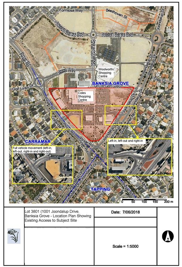
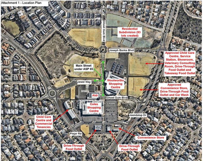
The subject site is located within the Banksia Grove District Centre and is bound by Pinjar Road on the south-west, Joondalup Drive on the south-east and Ghost Gum Boulevard, two private lots and a Public Recreation and Drainage reserve on the north. A location plan of the subject site is included in Attachment 1.
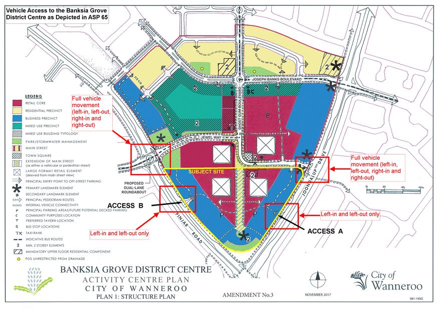
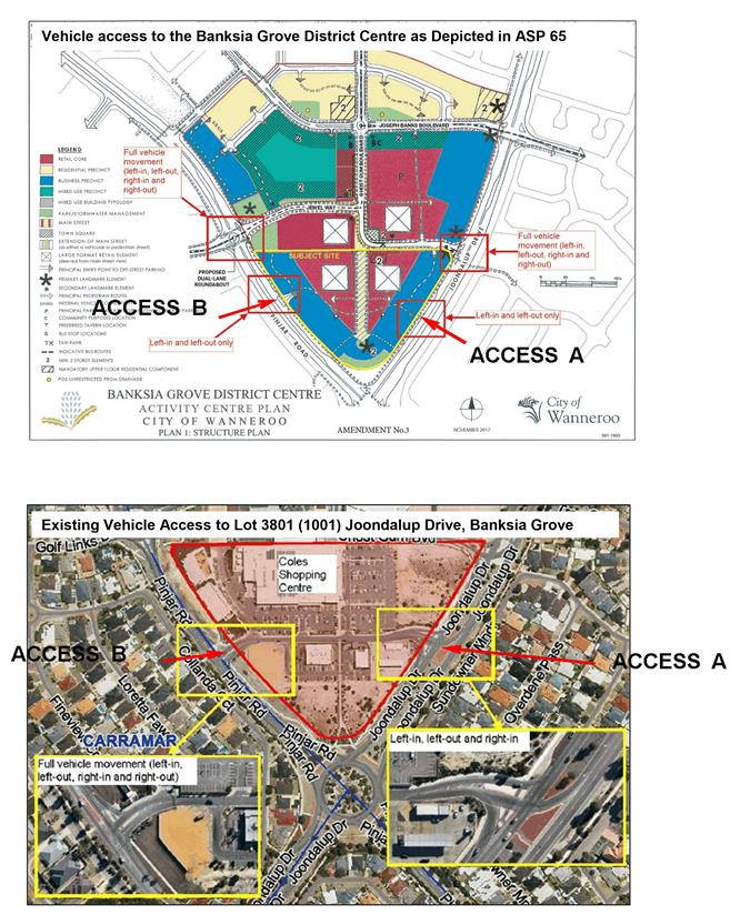
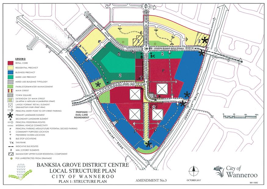
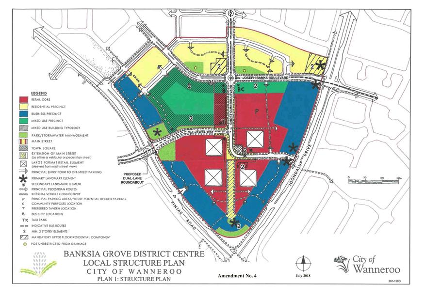
Vehicle Access Arrangements for the Banksia Grove District Centre under ASP 65
Agreed Structure Plan No. 65 – Banksia Grove District Centre (ASP 65) depicts direct vehicle access to the subject site from Joondalup Drive (Access A) and Pinjar Road (Access B), with both access points shown as accommodating left-in and left-out vehicle movements only.
ASP 65 depicts full vehicle movement (left-in, left-out, right-in and right-out) at the intersections of Pinjar Road and Jewel Way, as well as at the intersection of Joondalup Drive and Ghost Gum Boulevard. These intersections were intended to be the principle access points to the overall District Centre from the east and west.
A copy of the ASP 65 map, which illustrates the above access arrangements, is included as Attachment 2.
In regard to the Ghost Gum Boulevard and Joondalup intersection it is noted that at the subdivision stage this intersection was constructed as left-in/left-out and right-in only as per the Western Australian Planning Commission’s subdivision approval 151520 dated 3 September 2015. The developer did not provide a right-out movement as it was considered
unacceptable following traffic modelling. Attachment 1 shows the ‘as constructed’ Ghost Gum Boulevard and Joondalup Drive intersection as per the subdivision approval.
Approved Vehicle Access Arrangements for the Subject Site
Stage 1 of the Banksia Grove District Centre (Coles Shopping Centre) was approved on the subject site by the Metro North-West Joint Development Assessment Panel (JDAP) on 30 May 2013 (DA2013/223). The Pinjar Road access (Access B) to the subject site was approved and constructed as a full intersection (left-in, left-out, right-in and right-out). The Joondalup Drive access (Access A) to the subject site was approved and constructed as a left-in, left-out and right-in intersection.
The departure from the access requirements of ASP 65 was approved due to the fact that the Pinjar Road/Jewel Way and Joondalup Drive/Ghost Gum Boulevard intersections had not yet been constructed at the time of the approval. As conditions of the development approval, Access A and Access B were required to be converted to left-in and left-out only intersections, once the Pinjar Road/Jewel Way and Joondalup Drive/Ghost Gum Boulevard intersections were fully constructed. These conditions of DA2013/223 are as follows:
d) The proponent entering into a legal agreement with the City of Wanneroo prior to the commencement of operation of any uses on the subject lot, to ensure that the proposed accesses at Pinjar Road and Joondalup Drive are redesigned and constructed as left-in, left-out accesses only at the proponent's cost, once alternative access to the subject site is available from the future eastward extension of Golf Links Drive between Pinjar Road and Joondalup Drive through the adjoining lot to the north. The legal agreement is to be prepared at the proponent's cost to the satisfaction and specification of the City of Wanneroo and is to be secured by way of a caveat in the City's favour on the title of the subject lot;
e) The proposed access treatments to Pinjar Road and Joondalup Drive shall be redesigned and constructed as left-in, left-out accesses only once alternative vehicular access to the site is available from the future eastward extension of Golf Links Drive between Pinjar Road and Joondalup Drive through the adjoining lot to the north. Detailed drawings of this connection and accompanying vehicle swept path movements shall be lodged with the City for its approval prior to the works commencing and the works shall thereafter be carried out in accordance with those drawings and maintained to the City's satisfaction and specification.
The ‘future eastward extension of Golf Links Drive between Pinjar Road and Joondalup Drive’ referred to in these conditions is now known as Jewel Way and part Ghost Gum Boulevard.
As part of a subsequent application (DA2014/275) to amend DA2013/223, condition d) above was modified as follows:
d) Satisfactory arrangements being made with the City of Wanneroo prior to any occupancy of the development, to ensure that the proposed accesses at Pinjar Road and Joondalup Drive are redesigned and reconstructed as left-in, left-out accesses only at the proponent's cost, once alternative access to the subject site is available from the future eastward extension of Golf Links Drive between Pinjar Road and Joondalup Drive through the adjoining lot to the north.
The effect of this modified condition was the removal of the requirement to secure the legal agreement with a caveat on the title of the subject site, as this arrangement was considered onerous on the landowner. The intent of condition d), which was to ensure that the required
intersection works were carried out to the City’s satisfaction, remains unchanged from DA2013/223.
Compliance with Access Arrangement Conditions of DA2013/223 and DA2014/275
To satisfy condition d) of DA2014/275, a legal agreement was prepared by the landowners of the subject site and was executed by the City on 8 May 2015.
In order to satisfy condition e) of DA2013/223, Access A and Access B actually needed to be redesigned and reconstructed to provide left-in and left-out movement only, following the construction of Jewel Way and Ghost Gum Boulevard.
Jewel Way and Ghost Gum Boulevard were constructed and opened to the public in January 2017.
In June 2017, MGA Town Planners, on behalf of Fabcot Pty Ltd (landowners of the Woolworths Shopping Centre site at 81 Ghost Gum Boulevard, Banksia Grove) wrote to the City, querying when condition e) of DA2013/223 would be satisfied. The City then wrote to the owners of the subject site to follow up on this condition. In October 2017 the City received this development application (DA2017/1410) for an amendment to DA2013/223 and DA2014/275, seeking to delete both conditions d) and e) of these approvals.
Detail
DA2017/1410 seeks to:
· Remove condition d) from DA2013/223 and DA2014/275; and
· Remove condition e) from DA2013/223.
The effect of the above would be that the existing access arrangements to the subject site from Pinjar Road and Joondalup Drive (illustrated in Attachment 1) would remain as they are, rather than being reconstructed as left-in and left-out only.
Consultation
Advertising was undertaken in writing, and was limited to the other landowners within the Banksia Grove District Centre. Advertising was undertaken for a period of 21 days commencing 3 April 2018 and closing 24 April 2018.
At the conclusion of the advertising period, one submission was received from MGA Town Planners, on behalf of Fabcot Pty Ltd. This submission objected to the proposal on the basis that retaining the existing vehicle accesses at Access A and Access B, specifically the right turn into the subject site from Joondalup Drive ie Access A, will have negative impacts on traffic flows and safety for the surrounding area.
A summary of the submission received and Administration’s responses are provided in the Comment section.
Comment
In support of DA2017/1410, the applicant provided a traffic report conducted by Uloth and Associates, dated 4 July 2017 (applicant’s traffic report), which recommended that the existing access arrangements to the subject site at Access A and Access B be retained as they are. The applicant’s traffic report contended that reconstructing the accesses to the subject site as left-in and left-out only would place an excessive and undesirable burden on the Pinjar Road/Jewel Way and Joondalup Drive/Ghost Gum Boulevard intersections to the
north. It is noted that the applicant’s traffic report took into account the expected traffic levels at the full development of the Banksia Grove District Centre, as well as the extension of Pinjar Road to Flynn Drive. The traffic report estimated that the future traffic volumes on Pinjar Road and Joondalup Drive where they abut the Banksia Grove Shopping Centre would be 18,030 and 28,510 vehicles per day respectively when Banksia Grove is fully developed. These traffic volumes include the volume of traffic generated by the Shopping Centre when fully developed.
The applicant’s traffic report was reviewed by the City’s Transport and Traffic Service Unit, who agreed with the conclusion and supported the retention of the existing access arrangements to the subject site.
The applicant’s traffic report was also reviewed by the Department of Planning, Lands and Heritage (DPLH), given that both Pinjar Road and Joondalup Drive are Other Regional Roads under the control of the Western Australian Planning Commission (WAPC). The DPLH agreed with the City’s position on retaining the existing access arrangements to the subject site.
As part of the advertising process, the submitter requested a copy of the applicant’s traffic report. The submitter then provided the City with their own traffic report conducted by Traffic and Transport Pty Ltd, dated 6 April 2018 (submitter’s traffic report). The submitter’s traffic report contended that the access arrangements for the subject site are unsafe and should be reconstructed as left-in and left-out only, as per condition e) of DA2013/223. The submitter’s traffic report was referred to the City’s Transport and Traffic Service Unit, who disagreed with the safety concerns raised and confirmed its support of retaining the existing access arrangements to the subject site. A more detailed discussion of Transport and Traffic’s response to the submitter’s traffic report is provided below:
|
Submitter’s Traffic Report Comments |
City’s Transport and Traffic Service Unit Response |
|
Main Roads WA have released crash data for 2017 which shows a dramatic increase in crash incidence from 2015 associated with the Joondalup Drive access to the subject site, particularly the right turn in. As the Centre develops, the crash incidences are likely to increase. |
A search of Main Roads WA crash data indicates that there were no reported crashes in 2017 associated with the entry from Joondalup Drive to the subject site. Therefore it is not considered that the percentage of right turn crashes from Joondalup Drive to the subject site have increased dramatically. |
|
There is significant vehicle queuing (up to four vehicles at time) taking place at the right turn in from Joondalup Drive to the subject site. |
While four-vehicle queuing for the right-turn into the subject site from Joondalup Drive is acknowledged, analysis documented in the applicant’s traffic report provides confirmation that the intersection has sufficient capacity to operate at a high level of service, for the existing and future traffic scenarios. |
|
The right turn movement from Joondalup Drive to the subject site should be removed. |
The intersection analysis provided in the applicant’s traffic report identified that Ghost Gum Boulevard will operate at a significantly worse level of service if the right turn in at from Joondalup Drive to the subject site is closed. Therefore it is considered that the closure of the right turn in from Joondalup Drive to the subject site would negatively affect the traffic flows at the Ghost Gum Boulevard/Joondalup Drive intersection, with high volumes of traffic and increase the chance of potential crashes. |
Vehicle Access Arrangements on Structure Plan Map
It is noted that a report for Amendment No. 4 to ASP 65 is being presented to Council at the same time as this report. As part of Amendment 4 to ASP 65, it is proposed that the Structure Plan Map be modified to reflect the retention of the existing vehicle access arrangements for the subject site.
Should this application (DA2017/1410) not be supported by Council, a recommendation will need to be added to the report on Amendment No. 4 to ASP 65 to retain the existing Structure Plan Map.
Conclusion
The development application has been the subject of public consultation with one objection being received. Administration considers that the issues raised in the objection have been addressed and no modification to the proposal is required. It is therefore recommended that Council approve the application (DA2017/1410) to remove condition d) from DA2013/223 and DA2014/275 and to remove condition e) from DA2013/223, allowing the existing access arrangements for Lot 3801 (1001) Joondalup Drive, Banksia Grove to remain unchanged.
If Council resolves to approve DA2017/1410 as recommended, the applicant would then be able to apply to the City to dissolve the legal agreement which was executed as part of condition d) of DA2013/223 and DA2014/275.
Statutory Compliance
This application has been assessed in accordance with the City of Wanneroo’s District Planning Scheme No. 2.
Strategic Implications
The proposal aligns with the following objective within the Strategic Community Plan 2017 – 2027:
“3 Environment (Built)
3.5 Connected and Accessible City
3.5.1 Deliver local transport infrastructure including roads, footpaths and cycle ways to improve accessibility”
Risk Management Considerations
There are no existing Strategic or Corporate risks within the City's existing risk registers which relate to the issues contained in this report.
Policy Implications
Nil
Financial Implications
Nil
Voting Requirements
Simple Majority
That Council:-
1. Pursuant to Clause 68(2)(b) of the Deemed Provisions of District Planning Scheme No. 2, APPROVES the Development Application (DA2017/1410) to remove condition d) from DA2013/223 and DA2014/275 and to remove condition e) from DA2013/223, allowing the existing access arrangements for Lot 3801 (1001) Joondalup Drive, Banksia Grove to remain.
2. ADVISES the submitter of its decision.
Attachments:
|
1⇩. |
Lot 3801 (1001) Joondalup Drive, Banksia Grove - Location Plan |
18/225538 |
|
|
2⇩. |
ASP 65 Map |
18/225628 |
|
CITY OF WANNEROO Agenda OF Ordinary Council Meeting 24 July, 2018 60
PS06-07/18 Consideration of Amendment No. 4 to the Banksia Grove District Centre Agreed Structure Plan No. 65
File Ref: 2943-04 – 18/198371
Responsible Officer: Director Planning and Sustainability
Disclosure of Interest: Nil
Attachments: 5
Issue
To consider submissions received during public advertising of Amendment No. 4 to the Banksia Grove District Centre Agreed Structure Plan (ASP 65).
|
Applicant |
Element |
|
Owner |
Coles Group Property Development |
|
Location |
Banksia Grove District Centre |
|
Site Area |
Approximately 24 hectares |
|
MRS Zoning |
Urban |
|
DPS 2 Zoning |
Urban Development |
|
ASP 65 Zoning |
Retail Core, Residential Precinct, Business Precinct and Mixed Use Precinct |
Background
On 17 May 2017, TPG + Placematch (now Element), on behalf of Peet and Co Ltd Atf Yatala Unit Trust lodged Amendment No. 4 to ASP 65 for the City’s consideration. The amendment relates to the Banksia Grove District Centre (subject site), which consists of Lot 3801 (1001) Joondalup Drive, Lot 9187 (401K) Grandis Boulevard, Lot 88 (3) Jewel Way and Lot 140 (81) Ghost Gum Boulevard, Banksia Grove. The portion of Lot 9187 (401K) Grandis Boulevard which is located north of Joseph Banks Boulevard and east of Ghost Gum Boulevard has been subdivided into 93 residential lots. Attachment 1 contains a location plan of the subject site.
On 28 March 2018, the Manager Approval Services forwarded a memorandum to all Elected Members advising that advertising of Amendment No. 4 to ASP 65 would commence on 10 April 2017 in accordance with Clause 18 of the Deemed Provisions of District Planning Scheme No. 2 (DPS 2).
Development Application for Modifications to Vehicle Access Arrangements
ASP 65 depicts direct vehicle access to Lot 3801 (1001) Joondalup Drive, Banksia Grove (Coles Shopping Centre site) from Joondalup Drive and Pinjar Road, with both vehicle access points shown as accommodating left-in and left-out vehicle movements only. The access off Joondalup Drive is denoted as Access A and the access off Pinjar Road is denoted as Access B in Attachment 2.
The development application for the Coles Shopping Centre (DA2013/223) was approved by the Metro North-West Joint Development Assessment Panel (JDAP) on 30 May 2013. Contrary to ASP 65, Access B from Pinjar Road was approved and constructed as a full intersection (left-in, left-out, right-in and right-out) and Access A from Joondalup Drive was approved and constructed as a left-in, left-out and right-in intersection (see Attachment 2). As conditions of DA2013/223 these intersections were to be reconstructed as left-in and left-out only, once the Golf Links Drive extension (now composed of Jewel Way and a portion of Ghost Gum Boulevard) was constructed.
As shown in Attachment 1, both Jewel Way and Ghost Gum Boulevard have now been fully constructed, however the vehicle accesses to the Coles Shopping Centre site (i.e., Access A and Access B) have not been reconstructed as left-in and left-out only.
On 25 October 2017, the City received a development application (DA2017/1410) which seeks to amend the original development approvals for the Coles Shopping Centre site. The amendment proposes to remove the vehicle access conditions of the previous approvals, meaning that existing vehicle access arrangements at Access A and Access B can be retained. A traffic report was provided with the application which supports this proposal. As discussed in the Council Report for DA2017/1410, which is also being presented at the 24 July 2018 meeting, Administration is supportive of retaining the existing vehicle access arrangements for the Coles Shopping Centre site. The impact of DA2017/1410 on Amendment No. 4 to ASP 65 will be discussed in detail later in this report.
Detail
A Drive-Through Food Outlet is currently a not permitted ‘X’ use within the Business Precinct of ASP 65.
Amendment No. 4 to ASP 65 proposes to include Drive-Through Food Outlet as a discretionary ‘A’ use in the Business Precinct of ASP 65, and proposes to modify the vehicle access arrangements in the Structure Plan Map. These proposed modifications are detailed below.
Drive-Through Food Outlet as a Discretionary ‘A’ use in the Business Precinct of ASP 65
Amendment No. 4 to ASP 65 proposes to include Drive-Through Food Outlet as a discretionary ‘A’ use, subject to advertising in accordance with Clause 64 of the Deemed Provisions of DPS 2, within the Business Precinct.
The amendment proposes to make the land use an ‘A’ permissibility, subject to a Drive-Through Food Outlet being located on an internal road only, rather than on Joondalup Drive or Pinjar Road, so as to ensure safe and efficient movement of traffic on the surrounding road network.
The definition of Drive-Through Food Outlet under DPS 2 is:
“A take-away food outlet which includes the sale and serving of food direct to persons driving or seated in motor vehicles. The term may or may not include the preparation of food for sale or consumption within the building; or portion thereof.”
Vehicle Access Arrangements on Structure Plan Map
As discussed in the Background section of this report, Administration is supportive of retaining the existing vehicle access arrangements to the Coles Shopping Centre site at Access A and Access B as part of DA2017/1410. Amendment No. 4 to ASP 65 proposes to modify the Structure Plan Map to reflect these vehicle access arrangements.
A copy of the Amendment No. 4 to ASP 65 document is included as Attachment 3.
Consultation
In accordance with Clause 18 of the Deemed Provisions of DPS 2, the proposed amendment (contained in Attachment 3) was advertised for public comment for a period of 28 days by means of an advertisement in the Wanneroo Times, notice on the City's website, letters to surrounding landowners and the placement of two signs on the subject site. The advertising
period commenced on 10 April 2018 and closed on 8 May 2018, with four submissions being received. One submission objected to the proposal, and three submissions (from Main Roads Western Australia, the Department of Planning, Lands and Heritage, and the Department of Fire and Emergency Services) provided comments only.
The main issues raised during the advertising period relate to potential noise, traffic and littering associated with Drive-Through Food Outlets. A summary of the submissions and Administration’s response is included as Attachment 4.
As the retention of the existing vehicle accesses to the Coles Shopping Centre site was advertised as part of DA2017/1410, no further advertising for these access arrangements was undertaken as part of the consideration of Amendment No. 4 to ASP 65.
Following advertising of Amendment No. 4 to ASP 65, a minor text provision was added to the proposed amendment, specifying that a Drive-Through Food Outlet would only be considered as an ‘A’ use where it was proposed on an internal road. This change is considered minor in nature and is not considered to warrant readvertising of the amendment. A copy of the Amendment No. 4 to ASP 65 document, as modified after advertising, is included as Attachment 5.
A more detailed discussion of the major issues raised during the course of advertising and those identified by Administration in its assessment of the proposal is provided in the Comment section.
Comment
A Drive-Through Food Outlet is currently a not permitted ‘X’ use within the Business Precinct of ASP 65. The Business Precincts are located adjacent to Pinjar Road and Joondalup Drive, as shown on the Structure Plan Map included in Attachment 3.
The applicant has provided the following justification for including Drive-Through Food Outlet as a discretionary ‘A’ use within the Business Precinct:
· Under DPS 2, a Drive-Through Food Outlet is a discretionary ‘D’ use in both the Business and Commercial zones. Therefore, the proposed amendment would be consistent with the land use permissibility under DPS 2;
· Other car-based land uses, such as Showroom, Car Wash and Service Station, are either permitted ‘P’ or discretionary ‘D’ uses in the Business Precinct of ASP 65. Furthermore, a Restaurant is a discretionary ‘D’ use in the Business Precinct of ASP 65. A Drive-Through Food Outlet, which is both car-based, and involves the preparation of food, is considered to be compatible with these types of land uses;
· ASP 65 designates a pedestrian-focussed main street and town square at the centre of the structure plan area (incorporating portions of Ghost Gum Boulevard and Jewel Way), as shown on the Structure Plan Map. The proposed amendment will allow for car-based land uses to be consolidated in the outer portions of the structure plan area along Pinjar Road and Joondalup Drive, away from the central Main Street and Town Square; and
· The safe and efficient movement of traffic on the surrounding road network will be maintained through a provision restricting the siting of a Drive-Through Food Outlet to internal streets only (not on Pinjar Road or Joondalup Drive).
In addition to the applicant’s justification above, Administration considers that the proposed Amendment No. 4 to ASP 65 is acceptable for the following reasons.
Consolidating Car-based Land Uses outside of the Core of the Banksia Grove District Centre
One of the overarching principles of ASP 65 is the provision of a concentrated retail core around the Main Street and Town Centre, providing for a range of uses which address the street, and an active public realm. Consistent with this principle is the establishment of a Retail Core Precinct within the centre of the structure plan area, surrounded by a Business Precinct abutting Pinjar Road and Joondalup Drive. The intent of each of these precincts, as outlined in ASP 65, are:
Retail Core Precinct: provide “a range of retail, recreational, civic and commercial activity…concentrated around the Main Street and Town Square”; and
Business Precinct: provide “a range of less intensive commercial activities such as showrooms and service stations along Joondalup Drive and Pinjar Road.”
A Drive-Through Food Outlet is a discretionary ‘A’ use, subject to advertising, within the Retail Core Precinct. Notwithstanding, a Drive-Through Food Outlet is considered more suitable within the Business Precinct than within the Retail Core Precinct, where it would be considered detrimental to the operation of the pedestrian-focussed Main Street and Town Square. Whilst a number of Drive-Through Food Outlets have already been approved within the Retail Core Precinct, it is noted that they have been located on the outer periphery of the Retail Core, adjoining other car-based uses within the Business Precinct (see Attachment 1).
The inclusion of a Drive-Through Food Outlet as a discretionary use within the Business Precinct would allow it to be consolidated with other car-based uses away from the Main Street and Town Square, consistent with the principles of ASP 65.
Control of Noise and Traffic Issues
One of the submissions received during the advertising period raised an objection on the basis that a Drive-Through Food Outlet would create traffic and noise impacts, which would detrimentally impact the surrounding area.
In relation to the objection based on traffic, it is noted that a Drive-Through Food Outlet is already a use capable of approval within the Retail Core Precinct of the Banksia Grove District Centre. If a proposed Drive-Through Food Outlet development is likely to have a moderate (10 – 100 vehicle trips in peak hour) to high (over 100 vehicle trips in peak hour) impact on the existing traffic network, a traffic impact statement or traffic impact assessment will be required at the development application stage.
In relation to the objection based on noise, it is noted that the majority of the Business Precinct is separated from the surrounding residential areas to the west and east by Pinjar Road (a 58m road reserve), and Joondalup Drive (a 65m road reserve). Furthermore, the amendment proposes to restrict Drive-Through Food Outlets to the internal streets of the Centre, rather than on Pinjar Road or Joondalup Drive. As such, the addition of further Drive-Through Food Outlets within the Banksia Grove District Centre would not be expected to significantly increase the noise impacts for the surrounding residential properties. Notwithstanding, if the City had a particular concern relating to noise associated with a proposed Drive-Through Food Outlet development, an acoustic report could be requested at the development application stage to demonstrate compliance with the Environmental Protection (Noise) Regulations 1997.
Location of Drive-Through Food Outlet on Internal Streets Only
As part of the advertising process, a submission was received from Main Roads Western Australia, advising that:
· No direct vehicle access should be permitted from a Drive-Through Food Outlet to either Joondalup Drive or Pinjar Road, as these are major arterial roads for the precinct; and
· Any new vehicle accesses to a Drive-Through Food Outlet within the internal road network should be located as far away as possible from the intersections at Joondalup Drive and Pinjar Road.
Following the advertising period, the proposed amendment was modified by the applicant to make Drive-Through Food Outlet an ‘A’ land use, subject to the use being located on an internal road only, rather than on Joondalup Drive or Pinjar Road. Administration is supportive of this modification, given that it addresses the submission made by Main Roads Western Australia.
The final location of driveways to future Drive-Through Food Outlet developments from the internal road network may be assessed at the development application stage.
Proposed Intersection Modifications
Access A and Access B
As detailed in the Background of this report, Administration is supportive of DA2017/1410, which proposes to retain Access A and Access B to the Coles Shopping Centre site from Joondalup Drive and Pinjar Road (as shown in Attachment 2). This is because a traffic report was provided with DA2017/1410, which demonstrated that retaining the existing vehicle accesses is acceptable from a vehicle safety and traffic circulation perspective. As such, Administration is supportive of a modification to the Structure Plan Map of ASP 65 to reflect these retained accesses.
If DA2017/1410 is not supported by Council, the City’s Recommendation for Amendment No. 4 to ASP 65 will need to be amended as follows:
Pursuant to subclause 20(2)(e) of the Deemed Provisions of District Planning Scheme No. 2 RECOMMENDS to the Western Australian Planning Commission that the proposed Amendment No. 4 to the Banksia Grove District Centre Agreed Structure Plan No. 65 should be APPROVED, subject to the following modification:
· No changes being made the vehicle access arrangements depicted in the Structure Plan Map.
Ghost Gum Boulevard/Joondalup Drive intersection
In regard to the Ghost Gum Boulevard and Joondalup Drive intersection it is noted that at the subdivision stage this intersection was constructed as a left-in/left-out and right-in only intersection as per the Western Australian Planning Commission’s subdivision approval 151520 dated 3 September 2015. The developer did not provide a right-out movement according to ASP 65 as it was considered unacceptable following traffic modelling. Attachment 1 shows as constructed Ghost Gum Boulevard and Joondalup Drive intersection as per the subdivision approval.
Considering the above, it is recommended that ASP 65 be modified to depict the Ghost Gum Boulevard and Joondalup Drive intersection as a left-in/left-out and right-in intersection.
Conclusion
Administration considers that the proposed Amendment No. 4 to ASP 65 is acceptable for the reasons discussed in the body of the report. It is therefore recommended that Amendment No. 4 to ASP 65 as shown on Attachment 5 be supported with modification to depict the Ghost Gum Boulevard and Joondalup Drive intersection as a left-in/left-out and right-in intersection and forwarded the amendment to the WAPC for its consideration.
Statutory Compliance
This Structure Plan Amendment has been processed in accordance with the requirements of DPS 2.
Strategic Implications
The proposal aligns with the following objective within the Strategic Community Plan 2017 – 2027:
“2 Economy
2.1 Local Jobs
2.1.2 Build capacity for businesses to grow”
Risk Management Considerations
There are no existing Strategic or Corporate risks within the City's existing risk registers which relate to the issues contained in this report.
Policy Implications
This proposal has been assessed against the relevant provisions of the following:
· State Planning Policy 4.2: Activity Centres for Perth and Peel
· Local Planning Policy 3.2: Activity Centres
Financial Implications
Nil
Voting Requirements
Simple Majority
That Council:-
1. Pursuant to subclause 20(2)(e) of the Deemed Provisions of District Planning Scheme No. 2 RECOMMENDS to the Western Australian Planning Commission that the proposed Amendment No. 4 to the Banksia Grove District Centre Agreed Structure Plan No. 65, as submitted by Element on behalf of Coles Group Property Development, and included as Attachment 5, should be APPROVED WITH MODIFICATION to the Ghost Gum Boulevard and Joondalup Drive intersection as a left-in/left-out and right-in intersection ;
2. Pursuant to subclause 20(2) of the Deemed Provisions of District Planning Scheme No. 2 PROVIDES a copy of the report on the proposed amendment to the Western Australian Planning Commission;
3. ENDORSES Administration’s responses to the submissions as provided in Attachment 4; and
4. ADVISES the applicant and the submitter of its decision.
Attachments:
|
1⇩. |
Amendment No. 4 to ASP 65 - Location Plan |
18/250589 |
|
|
2⇩. |
Amendment No. 4 to ASP 65 - Vehicle Access to the Banksia Grove District Centre |
18/265564 |
|
|
3⇩. |
Amendment No. 4 to ASP 65 - Amendment Report (Advertised) |
18/250620 |
|
|
4⇩. |
Amendment No. 4 to ASP 65 - Summary of Submissions |
18/243305 |
Minuted |
|
5⇩. |
Amendment No. 4 to ASP 65 - Amendment Report (Modified After Advertising) |
18/250638 |
Minuted |
CITY OF WANNEROO Agenda OF Ordinary Council Meeting 24 July, 2018 74
PS07-07/18 Consideration of Development Application (DA2017/1540) - Telecommunications Infrastructure (Monopole) at Lot 690 (154) Landbeach Boulevard, Butler
File Ref: DA2017/1540 – 18/204717
Responsible Officer: Director Planning and Sustainability
Disclosure of Interest: Nil
Attachments: 5
Issue
To consider a development application (DA2017/1540) for Telecommunications Infrastructure (Monopole) at Lot 690 (154) Landbeach Boulevard, Butler (subject site).
|
Applicant |
Service Stream Ltd |
|
Owner |
The Trust Company Ltd |
|
Location |
Lot 690 (154) Landbeach Boulevard, Butler |
|
Site Area |
6087m2 |
|
DPS 2 Zoning |
Urban Development |
|
ASP 27 Zoning |
Service Industrial |
Background
On 25 October 2017, the City received a development application for Telecommunications Infrastructure (Monopole) at the subject site.
The subject site is bounded by Landbeach Boulevard to the west, warehouse units to the north, road reserve to the east for the future Mitchell Freeway, and residential lots to the south. A location plan of the subject site is included in Attachment 1.
The subject site is currently approved for use as a Storage Yard (DA2014/1333). The existing development is two storeys with separate storage units contained within the buildings. There is a total combined floor area of 7,384m2, and a total of 34 car bays provided on site. The storage units are individually leased out with security gates located within the site where access is permitted to storage customers only.
As a result of consultation for the proposed Telecommunications Infrastructure (discussed below), amended plans were submitted to the City reducing the maximum width of the pole component, which is the subject of this report.
Detail
The development application proposes the construction of Telecommunications Infrastructure. Telecommunications Infrastructure is a “D” (Discretionary) use in the Service Industrial zone. The details of the development are as follows:
· One monopole with a total height of 31.3m, located towards the south-east portion of the site, with a setback of 96m to the western boundary, 42m to the northern boundary, 15m to the eastern boundary and 2.1m to the southern boundary;
· Antennas attached directly onto the monopole with a maximum width of 2.3m;
· One equipment room located within an existing storage yard unit, directly to the east of the proposed monopole; and
· Four bollards surrounding the base of the monopole.
Plans depicting the proposal are included in Attachment 2.
Telecommunications Infrastructure is a “D” (Discretionary) use in the Service Industrial zone. Upon assessment of the development application it was determined that the proposal incorporates the following variations to the City’s Local Planning Policy 2.5: Telecommunications Infrastructure (LPP 2.5):
· The proposed monopole should not be located on a lot which adjoins a lot zoned ‘Residential’. The proposal adjoins Residential zoned lots to the south.
· The proposal should be located away from street boundaries and behind any buildings that exist on the same land. Whilst the proposed monopole is located 95m away from the street boundary, it is located in front of the existing building at the rear of the site, rather than behind the building; and
· Given that the proposed monopole is located in front of the existing building, it is not screened from view from the public domain and residential properties, and therefore may result in a loss of amenity.
These variations are discussed in detail in the Comment section below.
Consultation
LPP 2.5 outlines that if an application does not satisfy the ‘Deemed-to-Comply’ criteria of the Policy, variations may be considered subject to consultation. As noted above, the proposal does not meet L2, L3, D1 and D5 of LPP 2.5, and therefore public consultation was required.
The application was advertised for public consultation for a period of 21 days between 13 February 2018 and 6 March 2018 in accordance with LPP 2.5 and Clause 64(3) of the Deemed Provisions of the City’s District Planning Scheme No. 2 (DPS 2). Advertising was undertaken by way of a notice placed on the City’s website, in the Wanneroo Times and North Coast Times, a sign erected on site, and landowners within a 200m radius of the subject site notified in writing. At the conclusion of the comment period, six submissions were received, with five objections and one in support of the proposal. A summary of submissions received and Administration’s responses are shown in Attachment 3, and a plan depicting the location of the properties from where the submissions were received and landowners who were notified in writing is shown in Attachment 4.
The main issues raised during the advertising period and following detailed assessment by Administration relate to:
· The impact on the amenity of the surrounding landowners who will be able to view the monopole from their properties; and
· The proximity of the proposed Telecommunications Infrastructure to residential properties and schools, given the potential associated health impacts relating with Telecommunications Infrastructures.
A more detailed discussion of the major issues raised during the public consultation period as well as those considered in the assessment of the application is provided in the Comment section.
As a result of the objections received during public consultation, the applicant modified the plans to reduce the width of the proposal to minimise its visual impact. The initial proposal consisted of headframes (which supported antennas) attached to the monopole which had a maximum width of 4.3m. The modified proposal reduces this width to 2.3m by removing the headframes and attaching the antennas directly onto the monopole.
Comment
The development application has been assessed against the following:
· The Matters to be Considered by Local Government, included in Clause 67 of the Deemed Provisions of DPS 2;
· LPP 2.5: Telecommunications Infrastructure; and
· State Planning Policy 5.2: Telecommunications Infrastructure (SPP 5.2).
Assessment against LPP 2.5
The applicant proposes the following variations to the ‘Deemed-to-Comply’ provisions of LPP 2.5. In response to the variations, Administration provides the following comments:
|
Deemed-to-Comply Provisions |
Variations to the Deemed-to-Comply Provisions |
Administration Comments |
|
L2: Proposed telecommunications infrastructure is not located on a lot where an adjoining lot is zoned Residential, Mixed Use, Special Rural, Rural Community, Landscape Enhancement or Special Residential. |
The proposed infrastructure is located on a lot where the adjoining lots to the south are zoned Residential. |
· Whilst the proposed monopole is abutting Residential zoned lots, directly to the south of where the monopole is located, the land is used as a drainage sump that is owned and managed by the City, and therefore will not impact any residential properties. · The existing building to the rear of the site has also been constructed with no setback to the southern boundary, and therefore the proposed monopole is not considered to significantly contribute towards further impact. · In accordance with Clause 4.7.3 of DPS 2, where a non-residential development is abutting a Residential zoned lot, the minimum side setback is 6m for development with a height of two or more storeys. The nearest residential property is located approximately 70m to the south-west of the proposed location for the monopole. As the proposal is not directly adjacent to residential properties, it is considered that the 2.1m setback is adequate. |
|
L3: Proposed telecommunications infrastructure situated in the ‘Business’, ‘Commercial’, ‘Civic and Cultural’, ‘Service Industrial’ or ‘General Industrial’ zone should be located away from street boundaries, and behind any buildings that exist on the same land. |
The proposed infrastructure is situated in the Service Industrial zone, however it is located in front of the existing building (storage unit) on site rather than behind. |
· The proposed monopole is located in front of existing buildings at the rear of the site, approximately 95m from the street boundary. This assists in reducing the visual impact of the monopole as viewed from the street (see Attachment 5 for photomontages of the proposal). · The applicant is proposing to use the existing storage units on site to contain the equipment cabinet. This further reduces any visual impact to surrounding properties by integrating the Telecommunications Infrastructure with the existing buildings on site. |
|
D1: The applicant demonstrates that the proposed telecommunications infrastructure is confined to a height and dimension that balances the need to provide for appropriate network coverage for the surrounding area, whilst minimising loss of amenity in the locality. |
The height and dimensions of the proposed monopole has been designed to provide optimal network coverage whilst minimising impacts to amenity. However, given the proximity to residential areas, the proposal may result in a loss of amenity in the locality. |
· The monopole has been designed using non-reflective materials and neutral colours to reduce the visual impact of the proposal. · The applicant has amended the initial proposal from a 4.3m wide headframe, to a 2.3m wide structure. This has reduced the impact to the amenity of the locality. · Butler has been identified as lacking mobile phone service with the closest telecommunications infrastructure located in Jindalee. The proposed location has been selected to provide optimal mobile coverage and connectivity to meet the growing demands from the increased population in Butler. This proposal is therefore considered to be a necessary infrastructure to meet community needs. · The proposal accounts for co-location with three major carriers (Optus, Vodafone and Telstra) intending to share the proposed infrastructure. This reduces the need for separate additional telecommunications infrastructure within the locality. |
|
D5: The base of any monopole or lattice tower as well as any associated equipment shelters is screened from view from the public domain and adjoining properties by mature vegetation or other suitable screening or landscaping to the satisfaction of the City. |
There is no screening proposed for the base of the monopole as the subject site is built up and cleared of vegetation. |
· As discussed in L3, the applicant proposes using an existing storage unit to contain the equipment cabinet. As only the base of the monopole and associated bollards will be visible from the street, the proposal is therefore not considered to significantly impact on the amenity of the area. |
LPP 2.5 identifies that applications which do not satisfy the ‘deemed-to-comply’ criteria may be supported following consultation. In this instance, the proposed variations are supported for the reasons outlined above, and therefore Administration recommends that the application be approved by Council.
SPP 5.2 Telecommunications Infrastructure
Policy Measure 5.1.1(ii) of SPP 5.2 is the same as ‘Deemed-to-Comply’ criteria ‘D2’ of LPP 2.5, in that Telecommunications Infrastructure should be located and designed to minimise visual impact and whenever possible:
a) be located where it will not be prominently visible from significant viewing locations such as scenic routes, lookouts and recreation sites;
b) be located to avoid detracting from a significant view of a heritage item or place, a landmark, a streetscape, vista or a panorama, whether viewed from public or private land;
c) not be located on sites where environmental, cultural heritage, social and visual landscape values maybe compromised; and
d) display design features, including scale, materials, external colours and finishes that are sympathetic to the surrounding landscape.
The proposed monopole is designed and constructed to a finish consisting of neutral colours and non-reflective material. This is therefore sympathetic to the surrounding area. The proposed location is not considered a scenic route, lookout, recreation site, an area of significant view, or sites with environmental, cultural heritage, social and visual landscapes. On this basis, the proposal is considered to satisfy the requirements set out in SPP 5.2.
Clause 67 of the Deemed Provisions of DPS 2
In accordance with Part 4 of DPS 2, notwithstanding any noncompliance, Council may approve the application where deemed appropriate. In accordance with Clause 4.2.3, the power to approve an application where there is a non-compliance can only be exercised where Council is satisfied that approval of the development would be appropriate having regard to Clause 67 of DPS 2 and that the non-compliance will not have any adverse impact on the surrounding inhabitants (existing and future) and the locality. As the proposal does not comply with LPP 2.5, it has been assessed against Clause 67 and the impact of the surrounding locality as discussed below.
|
|
Matters to be Considered by Local Government |
Administration Comments |
|
c |
Any approved state planning policy |
As noted previously, the proposed development is consistent with Policy Measure 5.1.1(ii) of SPP 5.2, as the proposed monopole has been designed to minimise the visual impact as viewed from the street. |
|
g |
Any local planning policy for the Scheme area |
As discussed above, whilst aspects of the proposal do not meet the Deemed-to-Comply provisions of LPP 2.5, the proposal is considered to satisfactorily address the policy as it has been designed to minimise the impact to visual amenity of the locality. |
|
m |
The compatibility of the development with its setting including the relationship of the development to development on adjoining land or on other land in the locality including, but not limited to, the likely effect of the height, bulk, scale, orientation and appearance of the development |
As discussed above, the proposal is considered compatible on the proposed location for the following reasons: · Whilst the adjoining land is zoned Residential, the proposal directly abuts a drainage sump, with the nearest residential being located approximately 70m away. · The proposed design including dimensions, colours and location of the equipment cabinet has been planned to minimise impact to visual amenity. · The monopole supports co-location with three main carriers intending to share the infrastructure. · There is an existing lack of mobile network coverage within Butler. The location provides optimal network coverage to meet the growing demand from the community. |
|
s |
The adequacy of – i) The proposed means of access to and egress from the site; and ii) Arrangements of the loading, unloading, manoeuvring and parking of vehicles. |
· The proposal does not compromise vehicle access or manoeuvrability on the site. The current driveway only permits a one way access and has a width is 8m. The width between the proposed monopole and associated bollards to the existing buildings on site is 6.5m. This meets the minimum required driveway width of 6m in accordance with the Australian Standards 2890. |
Concerns Raised in Submissions
In response to the main concerns raised in the submissions received, Administration provides the following comments:
|
Concerns raised in Submissions |
Administration Comments |
|
The impact on the amenity of the surrounding landowners who will be able to view the monopole from their properties. |
As discussed above, the proposal is designed using non-reflective materials and neutral colours to reduce the visual impact of the proposal, and is setback approximately 70m to the closest residential property. It is therefore considered that the proposal is adequately setback to minimise impacts to the amenity of the surrounding landowners.
|
|
The proximity of the proposed Telecommunications Infrastructure to residential properties and schools, given the potential associated health impacts relating with Telecommunications Infrastructures. |
The relevant policies do not prescribe minimum separation distances to residential properties and schools. Notwithstanding, the closest residential property is approximately 70m to the south-west of the proposed location, and the closest school is located approximately 660m south of the proposed location. It is therefore considered that the proposal is adequately setback from residential properties and schools.
In regards to health impacts, as per Clause 4 of LPP 2.5, the City is not responsible for the monitoring and control of Electromagnetic Radiation (EMR) that could emanate from Telecommunications Infrastructure. Issues relating to EMR levels are not considered to be a valid planning consideration. |
Conclusion
In light of the above, the proposed variations for the Telecommunications Infrastructure are considered to satisfy Clause 67 of the Deemed Provisions of DPS 2. Administration considers that the issues raised in the submissions received have been addressed as discussed in Attachment 3 and no modification to the proposal is required. It is therefore recommended that Council approve the proposed Telecommunications Infrastructure at Lot 690 (154) Landbeach Boulevard, Butler.
Statutory Compliance
This application has been assessed in accordance with the City’s DPS 2.
Strategic Implications
The proposal aligns with the following objective within the Strategic Community Plan 2017 – 2027:
“3 Environment (Built)
3.4 Activated Places
3.4.2 Provide safe spaces, centres and facilities through our infrastructure management and designs for community benefit and recreation”
Risk Management Considerations
There are no existing Strategic or Corporate risks within the City's existing risk registers which relate to the issues contained in this report.
Policy Implications
The proposal has been assessed against the relevant provisions of the following:
· District Planning Scheme No. 2 (DPS 2);
· Agreed Structure Plan No. 27 Butler-Ridgewood;
· Local Planning Policy 2.5: Telecommunications Infrastructure (LPP 2.5); and
· State Planning Policy 5.2: Telecommunications Infrastructure (SPP 5.2).
Financial Implications
Nil
Voting Requirements
Simple Majority
That Council:-
1. Pursuant to Clause 68(2)(b) of the Deemed Provisions of the City of Wanneroo District Planning Scheme No. 2, APPROVES the Development Application (DA2017/1540) as shown in Attachment 2 for the Telecommunications Infrastructure at Lot 690 (154) Landbeach Boulevard, Butler, subject to compliance with the following conditions:
a) This approval only relates to the proposed Telecommunications Infrastructure, as highlighted on the approved plan. It does not relate to any other development on the site.
b) The use of the premises is to be Telecommunications Infrastructure as defined in the City of Wanneroo’s District Planning Scheme No. 2 as follows:
“Telecommunications Infrastructure: means any part of the infrastructure of a telecommunications network and includes any line, equipment, apparatus, tower, antenna, tunnel, duct, hole, pit or other structure used, in or in connection with a telecommunications network.”
c) Stormwater and any other water run-off from buildings or paved areas shall be collected and retained on site.
2. ADVISES the submitter of its decision.
|
1⇩. |
Attachment 1 - Location Plan - Lot 690 (154) Landbeach Boulevard, Butler |
18/204941 |
|
|
2⇩. |
Attachment 2 - Plans of the Proposal - Lot 690 (154) Landbeach Boulevard, Butler |
18/223839 |
Minuted |
|
3⇩. |
Attachment 3 - Schedule of Submissions - Telecommunication Infrastructure - Lot 690 (154) Landbeach Boulevard, Butler |
18/236646 |
|
|
4⇩. |
Attachment 4 - Landowners within 200m radius and location of submissions - 154 Landbeach Boulevard, Butler |
18/213166 |
|
|
5⇩. |
Attachment 5 - Computer Generated Photomontage - Lot 690 (154) Landbeach Boulevard, Butler |
18/236251 |
|
CITY OF WANNEROO Agenda OF Ordinary Council Meeting 24 July, 2018 91
PS08-07/18 Reconsideration of Development Application (DA2017/1500) for 28 Multiple Dwellings at Lot 153 (30) Bewick Avenue, Yanchep
File Ref: DA2017/1500 – 18/226992
Responsible Officer: Director Planning and Sustainability
Disclosure of Interest: Nil
Attachments: 5
Issue
The City has been requested to reconsider a development application for 28 Multiple Dwellings at Lot 153 (30) Bewick Avenue, Yanchep (subject site), in response to an invitation made by the State Administrative Tribunal (SAT).
|
Applicant |
Capital Industries |
|
Owner |
Primewest (Bewick Street) Pty Ltd |
|
Location |
Lot 153 (30) Bewick Avenue, Yanchep |
|
Site Area |
4,000m2 |
|
DPS 2 Zoning |
Urban Development |
|
ASP 68 Zoning |
Residential R50 |
Background
On 9 November 2017, the City received a development application for 28 Multiple Dwellings at the subject site. The subject site is bound by Bewick Avenue to the north-west, existing residential properties along Moorpark Avenue to the north-east, and public open space (POS) to the south-west and south-east. A location plan of the subject site is included in Attachment 1.
The application was assessed by Administration, and was not considered to satisfactorily address a number of aspects of the Residential Design Codes (R-Codes) and the Draft Apartment Design Policy (DADP), which was released for public comment in October 2016 by the Western Australian Planning Commission (WAPC), including:
· The provision of useable/accessible communal open space area/s;
· The provision of adequate landscaping; and
· The design having a suitable interface with the streetscape.
The applicant provided amended plans, however Administration did not consider that these issues were satisfactorily addressed, and advised the applicant that it would not support the plans as submitted. On 9 March 2018, Primewest, on behalf of Capital Industries, requested Administration determine the application based on the submitted plans. On 26 March 2018, Administration refused the application under delegated authority. Before determining the application, Administration did not undertake public consultation. The application was refused for the following reasons:
1. The application does not satisfy provision 3 of Local Development Plan No. 12 Yanchep City, Clause 6.2.1 ‘Street Surveillance’ of the Residential Design Codes and Clauses 3.7 ‘Public Domain Interface’ and 4.12 ‘Facades’ of the Draft Apartment Design Policy as the development does not adequately orientate towards or address the primary street frontage.
2. The application does not satisfy the requirements of Clause 6.3.2 of the Residential Design Codes and Clauses 3.4 ‘Deep Soils Areas’ and 3.5 ‘Communal and Public Open Spaces’ of the Draft Apartment Design Policy as insufficient communal open space and landscaping has been provided for the development.
3. The application does not satisfy the requirements of Clause 6.4.3 ‘Dwelling size’ of the Residential Design Codes and Clauses 4.10 ‘Apartment Mix’ Draft Apartment Design Policy as there is an insufficient range of dwelling types.
4. In determining the application, the City had due regard to the matters listed in Clause 67 of the Deemed Provisions of DPS 2. The application was not demonstrated to be consistent with the following items:
a) Clause 67 (f), as the proposal does not have due consideration for the Draft State Planning Policy 7 Design of the Built Environment and associated Draft Apartment Design Policy.
b) Clause 67(p), as the proposed landscaping provided is considered inadequate for the development.
c) Clause 67(m) and Clause 67(n)(ii), as the proposal does not demonstrate how it is compatible with the character of the locality, by way of its orientation and appearance, and potential impact on the streetscape and adjoining residential properties.
5. Having due regard to the Draft State Planning Policy 7 Design of the Built Environment and associated Draft Apartment Design Policy it is considered the application does not satisfy the number of design principles, including but not limited to, Landscape Quality, Functionality and Build Quality and Built Form and Scale.
State Administrative Tribunal (SAT) Proceedings
Following Administration’s decision, the applicant exercised their rights to seek a review of the decision at SAT. Following SAT mediation on 27 April 2018, SAT issued the following orders:
1. The applicant to provide amended plans to the City for assessment;
2. The City to advertise the development application, including the amended plans; and
3. The matter is adjourned to a further mediation.
The amended plans submitted in accordance with the SAT Orders made a number of changes to the refused plans, including:
· The modification of the units facing Bewick Avenue to orientate towards the street through the inclusion of unobscured major openings, and noting the colour of rendering on the drawings;
· The relocation of the bin store, bike racks, and a number of storerooms;
· The inclusion of an area for communal open space fronting Bewick Avenue, and the inclusion of additional areas of landscaping within the site; and
· The construction of four on-street parking bays within the Bewick Avenue road reserve.
The amended plans were advertised by Administration in accordance with the SAT Orders. Following this, SAT issued the following orders at mediation held on 5 June 2018:
1. The applicant to provide amended plans and a Traffic Impact Statement (TIS) to the City for assessment;
2. The City to reconsider its decision at the Council meeting on 24 July 2018; and
3. The matter is adjourned to a further mediation, pending the outcome of the reconsideration.
Detail
In accordance with the SAT Orders of 5 June 2018, the applicant provided amended plans to Administration which made a number of further modifications, including:
· The removal of bike racks (now to be located within the individual storerooms;
· The inclusion of two additional visitor parking bays;
· An update landscaping plan, including additional shade trees and the use of species consistent with the City’s specifications;
· Relocation of storerooms 18 and 19;
· Modifications to window heights to ensure compliance with the R-Codes requirements for privacy for adjoining properties; and
· The removal of fencing around the communal open space to improve accessibility.
These amended plans are the subject of this report, and are included in Attachment 2. 3D perspectives of the proposal are included in Attachment 3.
The development application proposes Multiple Dwellings which are a “D” (Discretionary) use in the Residential zone. The details of the development are as follows:
· 28 Multiple Dwellings, located within three separate two-storey buildings on the site in the following configuration:
o Building 1 – located along the south-western boundary of the subject site and consists of Units 1 to 7 on the ground floor and Units 8 to 14 on the upper floor;
o Building 2 – located along the south-eastern boundary of the subject site and consists of Units 15 – 20 on the ground floor and Units 21 – 26 on the upper floor; and
o Building 3 – located along the north-western boundary of the subject site and consists of Unit 27 on the ground floor and Unit 28 on the upper floor;
· 42 on-site parking bays, including 1 ACROD parking bay, and the construction of four on-street parking bays with the Bewick Avenue road reserve adjacent to the subject site, which satisfies the R-Codes requirements for 46 parking bays;
· The provision of approximately 664m2 of on-site landscaping (approximately 16% of the site area), including a communal open space area of 52m2 located adjacent to Bewick Avenue.
Administration has identified that there are a number of variations to the R-Codes, Yanchep City Local Development Plan No. 12 (LDP 12), Site Works and Retaining Local Planning Policy (LPP 2.4) and the DADP proposed. The major issues are discussed in the Comment section below, while the remainder are discussed in Attachment 4.
Consultation
In accordance with SAT Order 2 of 27 April 2018, the application was advertised by writing to affected landowners for a period of 14 days between 7 May 2018 and 21 May 2018. A copy of the plans was also made available on the City’s website.
At the conclusion of the comment period, a total of five submissions were received. Of these five submissions three specifically objected to the proposal, and one provided comment. The remaining submission did not specifically object to the proposal, although did raise some concerns. A summary of the submissions and Administration’s response to these is included in Attachment 5.
The main issues raised during the advertising period relate to the compatibility of the proposal given the surrounding development context, and the increasing of traffic as a result of the proposal. A more detailed discussion of the major issues considered in the assessment of the application is provided in the Comment section.
Comment
Consideration of Reasons for Refusal
Reason for Refusal 1 – Orientation and Addressing of Primary Street Frontage
The table below provides a comparison of how the revised plans address the variations related to orientation and addressing of the primary street frontage identified as part of the original refusal:
|
Refused Plans |
Revised Plans |
|
|
Clause 3 of LDP 12 Dwellings shall be designed to orientate towards the primary street and/or public open space |
||
|
Building 1 (U1 and U8) · Elevation did not contain any major openings to U1, and two small major opening to U8 (approximately 1.8m2 each). Elevation considered to look like the side of the building, rather than the front. Building 3 (U27 and U28) · No unobscured major openings provided, which is not considered to satisfactorily address Bewick Avenue. |
Building 1 (U1 and U8) · One of the highlight windows to U1 changed to a full height sliding door to the meals area. Size of both major openings to U8 increased to approximately 3.5m2 each. Balcony to U8 is open towards Bewick Avenue. Building 3 (U27 and U28) · Screening to U27 and U28 kitchens removed. Partially obscured window to office changed to a full height sliding door for U27, and 3.5m2 unobscured window for U28.
In light of these changes, the revised plans are considered to satisfactorily address the requirement for the dwellings to be oriented towards the primary street. |
|
|
Clause 6.2.1 C1.1 of the R-Codes The street elevation(s) to address the street with facades generally parallel to the street and with clearly definable entry points visible and accessed from the street |
||
|
Although clearly definable entry points to Building 1 and Building 3 provided, the elevations were not considered to address the street given the lack of openings provided, as detailed above. |
The elevations to the street include increased major openings, which minimises the provision of blank facades to the street.
In light of this, the revised plans are considered to satisfactorily address the requirement for the street elevations to address the street. |
|
|
Clause 6.2.1 C1.2 of the R-Codes The building has habitable room windows or balconies that face the street |
||
|
No major openings provided to U1, and no unobscured openings provided to U27 or U28. |
· U1 – Highlight window to the meals area converted to full height sliding door. · U8 – Size of both major openings increased from 1.8m2 to 3.5m2 each. · U27 – Partially obscured window to office converted to full height sliding door. · U28 – Partially obscured window to office converted to 3.5m2 unobscured window.
In light of these changes, the revised plans are considered to satisfactorily address the requirement for the provision of habitable room windows which face the street. |
|
|
Clause 3.7.1 of DADP Transition between private and public domain is achieved without compromising safety and security |
|
|
· Facades to Building 1 and 3 contain minimal openings, which leave large areas of blank facades. · No opportunities for casual interaction provided. · No information regarding building colours provided. |
· Facades to Building 1 and 3 changed to include greater amounts of major openings and the opening of the balcony for U8 towards Bewick Avenue, which provide for interaction with the public domain. · A landscaped communal open space area of approximately 52m2 has been provided adjacent to Bewick Avenue, to be used by residents and provides the opportunity for casual interaction between residents, and also with the public domain. · Information regarding the three render colours to be applied to the building has been provided.
In light of these changes, the revised plans are considered to be generally consistent with the objective for the transition between the public and private domain. |
|
Clause 3.7.2 of DADP Amenity of public domain is retained and enhanced |
|
|
· Bin store and car parking visible from the primary street. · No verge landscaping provided.
|
· Bin store has been relocated to the north-east boundary, and is no longer visible from the street. · Car parking remains visible from the street, however, these are to be used by visitors, which ensures that these will not be occupied by vehicles for long periods. The communal open space area has been located to provide some relief from the parking area, while additional trees have been provided along the front boundary to assist in screening. The provision of this landscaping treatment is considered to assist in ensuring there is minimal impact on the public domain. · Although no verge landscaping has been indicated, these can be addressed through the imposition of a condition requiring the verge to be landscaped, to the satisfaction of the City.
In light of these changes, the revised plans are considered to be generally consistent with the objective for the retention and enhancement of the public domain. |
|
Clause 4.12.1 of DADP Building facades provide visual interest along the street while respecting the character of the local area |
|
|
· Facades to Building 1 and 3 contain minimal openings, which leave large areas of blank facades. · No information regarding building colours provided. |
· Facades to Building 1 and 3 changed to include greater amounts of major openings and the opening of the balcony for U8 towards Bewick Avenue, which provide for interaction with the public domain. · Information regarding the three render colours to be applied to the building has been provided.
In light of these changes, the revised plans are considered to be generally consistent with the objective for the building façade to provide visual interest while respecting the character of the local area. |
In light of the above, Administration considers that aspects of the proposal which did not previously satisfy the requirements regards to orientation and addressing the street have been adequately addressed through the revised plans.
Reason for Refusal 2 – Provision of Communal Open Space and Landscaping
Deep Soil Areas
Clause 3.4 of the DADP requires developments on a site with an area greater than 1,500m2, provide a minimum of 12% of the site area as deep soil area (which is a minimum dimension of 6m, and can support the growth of medium to large canopied trees). Based on this, 480m2 of deep soil area is required to be provided. The refused plans provided a deep soil area of 70m2 in the north-east portion of the site. The revised plans propose a deep soil area of 52m2 in the communal open space area adjacent to Bewick Avenue). This equates to approximately 1.3% of the site area. This has been reduced as a result of this being relocated to a more accessible area, and as a result of accommodating other site planning requirements, such as car parking.
Administration considers that the shortfall of deep soil area is acceptable in this instance for the following reasons:
· The revised location for the communal space is more useable and accessible for residents than the previous location in the north-east corner of the site, and contribute towards providing a greater level of landscaping and amenity to the Bewick Avenue streetscape;
· A total area of approximately 664m2 of landscaping is provided across the site, particularly along the perimeter of the site and the pedestrian network within the site, which has substantially increased from previous plans. The location of this landscaping softens the edge of the built form of the dwellings, and provides connectivity with the adjoining POS. In particular, the strategic location of the landscaping and the deep soil area adjacent to Bewick Avenue assists in providing relief from built form and the hardstand parking area, and provides for an improved amenity of the streetscape; and
· The species proposed are consistent with the City’s preferred species, which ensures that vegetation will provide for an increased level of amenity and canopy cover when they have fully matured.
Communal Open Space
Clause 3.5 of the DAPD requires that communal open space be provided at a rate of 15% of the total site area for development proposing between 21 to 30 dwellings, and should be co-located with deep soil areas. Based on this, a communal open space area of 600m2 is required to be provided. The deep soil area proposed in this application is co-located with the communal open space. As noted in the Deep Soil Area section of this report, the communal open space area proposed is 52m2, which equates to 1.3% of the site area.
Administration considers that the shortfall of communal open space is acceptable in this instance for the following reasons:
· The additional area of communal open space adjacent to Bewick Avenue provides for a practical location to encourage informal interaction, given it is accessible from the street, front units, and the parking area;
· The south-east and south-west boundaries of the subject site adjoin an area of POS with an area of approximately 4.2ha, and which is vested with the Crown as a reserve for recreation. The entrance of this POS is approximately 5m to the south-west of the subject site. This POS provides a large area for recreational pursuits and interaction with the community. This also provides the residents of Building 1 and 2 with an attractive outlook, as these dwellings are orientated towards the POS in accordance with LDP 12; and
· In light of the proximity to the POS, the area of communal open space are considered to provide opportunities for interaction and improved amenity, with adequate surveillance provided from the units and the street.
Landscaping
Clause 6.3.2 C2(iii) of the R-Codes requires landscaping to be provided between each six consecutive external parking spaces, and to include shade trees where possible. The refused plans provide some narrow strips of landscaping between some parking bays, but there were large areas which did not incorporate landscaping. This is because the resident’s bays are covered, and it was not possible to include this landscaping at a consistent rate.
The amended plans provide an additional 9m2 of landscaping in front of Units 4 and 5, and Units 6 and 7 in front of the car parking bays. The amended plans also provide shade trees with the visitor parking area along the front of the subject site. This is considered to satisfy the Design Principles of Clause 6.3.2 P2 of the R-Codes for the following reasons:
· The landscaping meets the needs of the residents, as it provides an informal communal area for casual interaction (accounting for the proximity to the adjoining POS), and assists in softening the car parking area;
· The landscaping does not impact on the provision of a safe and secure environment for residents; and
· The landscaping proposed across the site is orientated towards Bewick Avenue, ensuring that the development contributes positively to the streetscape by softening the built form and minimising the amount of “hardscape” visible from the street.
In light of the above, Administration considers that the proposal satisfies the objectives of Clause 3.4 and 3.5 of the DADP with regards to the provision of deep soil and communal open space areas, and the Design Principles of Clause 6.3.2 of the R-Codes in respect to on-site landscaping.
Reason for Refusal 3 – Range of Dwelling Types
Clause 6.4.3 of the R-Codes requires that developments of more than 12 dwellings provide a minimum of 20% of 1 bedroom dwellings, and a minimum of 40% of 2 bedroom dwellings.
In this instance six 1 bedroom dwellings and eleven 2 bedroom dwellings are required. The application proposes the following:
· Six 1 bedroom dwellings. This equates to 21% of the development;
· Eight 2 bedroom dwellings. This equates to 29% of the development. A variation of 11%; and
· 14 three bedroom dwellings. This equates to 50% of the development.
In addition, Clause 4.10.1 of the DAPD identifies that a range of apartment types and sizes should be provided to cater for different household types.
Administration notes than in regards to the 1 bedroom dwellings, these all include a room depicted as an ‘office’, which could potentially be used as a second bedroom, and result in no 1 bedroom dwellings being provided. The applicant has provided justification for the proposed dwelling mix, which was not previously submitted to Administration when the application was first lodged. This is summarised below:
· Demographic evidence demonstrates that there is a preference for 2 bedroom dwellings;
· The developer is seeking to deliver an affordable housing product, and it is difficult for purchasers to obtain finance for apartments below 60m2 in Yanchep;
· The costs for the construction of 2 bedroom dwellings are approximately the same as for 1 bedroom dwellings; and
· The provision of the additional room provides flexibility, as this can be used for a study, storeroom or guestroom.
Administration considers that the proposal satisfies the Design Principle of Clause 6.4.3 P3, as the development provides for a diversity of dwelling types, being 50% three bedroom, 29% 2 bedroom, and 21% 1 bedroom dwellings. It is considered that this diversity will cater for different demographics, and provide options to cater for different needs of residents. It is also noted that under the carparking provisions of the R-Codes, the same requirement (1.25 bays per dwelling) is required for 1 and 2 bedroom dwellings. This indicates that no additional car parking is required on site should the 1 bedroom dwellings be used as 2 bedroom dwellings.
In light of the above, Administration considers that the proposal satisfies the Design Principles of Clause 6.4.3 of the R-Codes, and Clause 4.10.1 of the DAPD with regards to the provision of a range of dwelling types. Accordingly, Administration considers that this reason for refusal has now been addressed.
Reason for Refusal 4 – Matters to be Considered by Local Government of Clause 67 of the Deemed Provisions of DPS 2
The original application was assessed against the matters to be considered by local government of Clause 67 of the Deemed Provisions of DPS 2. It was identified that there were a number of these matters which the application did not demonstrate consistency with. Consideration to each of these matters given in the table below:
|
Clause 67(f) - Any policy of the State |
|
The proposal is considered to be consistent with the elements of the Draft State Planning Policy 7: Design of the Built Environment (Draft SPP 7), including landscape quality, built form and scale, and functionality and build quality are considered to have been addressed, as discussed in detail in the Reason for Refusal 5 section of this report. |
|
Clause 67(m) - The compatibility of the development with its setting including the relationship of the development to development on adjoining land or on other land in the locality including, but not limited to, the likely effect of the height, bulk, scale, orientation and appearance of the development |
|
The proposal is considered to be compatible with its setting, which consists of predominantly single storey Single Houses, for the following reasons: · The height of the development complies with the requirements of the R-Codes, with a maximum wall height of 6.6m (9m is permitted) and ridge height of 8.93m (12m is permitted). The height of the proposal is consistent with the development of a two storey Single House, which is permitted on the site; · The development is considered to have minimal impact on adjoining properties as a result of building bulk. This is due to the siting of the development between three buildings, rather than one. When viewed from the adjoining residential properties, the side elevation of Building 2 and 3 is visible, which has the appearance of a two-storey Single House, these elevations feature articulation which ensures that large sections of blank wall are not provided; · The scale of the development is consistent with that permitted for R50 under the R-Codes. Notwithstanding that the existing adjoining residents are coded R20 under DPS 2, the scale of the development is within the expectations of what can be developed on medium-density sites such as this; and · The appearance of the development when viewed from the street has been improved, as discussed in the Reason for Refusal 1 and Reason for Refusal 2 sections of this report. |
|
Clause 67(n)(ii) - The amenity of the locality including the character of the locality |
|
The proposal is considered have a negligible impact on the locality for the following reasons: · The visual amenity of the locality will be improved by the orientation of the development towards the primary street, and the addition of landscaping to soften the built form of the development, as detailed in the Reason for Refusal 1 and Reason for Refusal 2 sections of this report; · While there are no existing Multiple Dwelling developments within the immediate locality, the proposal is consistent with the development requirements of the medium-density R50 coding applicable to the site. Noting that the adjoining properties along Moorpark Avenue are coded R20, the proposal is considered to be appropriate for the site, and will have a negligible impact on the locality for the reasons outlined above in considering Clause 67(m); and · As discussed further in the Traffic section of this report, while there is an increase in traffic as a result of the proposal, this can be accommodated within the existing road network, with a negligible impact on amenity as a result. |
|
Clause 67(p) - Whether adequate provision has been made for the landscaping of the land to which the application relates and whether any trees or vegetation on the land should be preserved |
|
The proposals provide additional landscaping across the site, as well as a more functional and accessible deep soil and communal open space areas which contributes positively to the streetscape, and softens the built form of the development as outlined in the Reason for Refusal 2 section of this report. It is noted that the subject site is currently vacant of vegetation. |
In light of the above, Administration considers that the proposal has demonstrated consistency with the matters to be considered by local government of Clause 67 of the Deemed Provisions of DPS 2.
Reason for Refusal 5 – Consideration of Draft SPP 7 Design Principles
The original application was considered against the design principles of Draft SPP 7. It was identified that there were a number of these design principles which the application did not demonstrate consistency with. Consideration of each of these matters in light of the revised plans is given in the table below:
|
2 - Landscape quality Good design recognises that together landscape and buildings operate as an integrated and sustainable system, within a broader ecological context. |
|
· The design incorporates landscaping along the primary street and perimeter of the site to soften the built form of the development and enhance the appearance of it from the streetscape. This also provides a connection with the existing POS which abuts the site; · The provision of an accessible and landscaped communal open space area adjacent to the primary street assists in integrating green infrastructure within the site, and providing a space where informal interactions between residents and pedestrians can occur; and · The species proposed are consistent with the City’s preferred species, which ensures that they will provide for an increased level of amenity and canopy cover when they have fully matured, whilst remaining easy to manage and maintain for the long term. |
|
3 - Built form and scale Good design provides development with massing and height that is appropriate to its setting and successfully negotiates between existing built form and the intended future character of the local area. |
|
· The height and scale of the development is consistent with that permitted for a site with a density code of R50, and has been designed so that any impact on the existing adjoining residential properties as a result of building bulk is negligible; · The street orientation and appearance of the buildings have been improved through changes to the façades and the provision of additional landscaping, to enhance the appearance of the development from the public realm; and · The orientation of the buildings provides an outlook for residents which is of high amenity, overlooking the existing POS. |
|
4 – Functionality and Build Quality Good design meets the needs of users efficiently and effectively, balancing functional requirements to deliver optimum benefit and performing well over the full life-cycle. |
|
· The proposal makes provision for the functional needs of its residents by providing storerooms, drying areas and a bin store, without compromising on amenity from such services as these are not visible from the street. Some of the storerooms are proposed along the boundary of the public open space, however this is proposed for short lengths which minimises any adverse visual impact; and · The design provides for communal open space areas that can be accessed by residents, are provided with passive surveillance to ensure they are safe, and be adapted for varying uses in the future. |
In light of the above, Administration considers that the proposal has demonstrated consistency with the design principles of Draft SPP 7. Accordingly, Administration considers that this reason for refusal has now been addressed.
Issues Raised During Public Consultation
Compatibility of Development
During the advertising period, a number of submissions were received which raised concerns with the compatibility of the development with existing residential development within the Yanchep locality. Currently, the locality consists of predominantly single storey development. The surrounding residential development along Moorpark Avenue is coded R20 under DPS 2, and is not covered by the Yanchep City Agreed Structure Plan No. 68 (ASP 68). The residential properties to the north-west of the subject site are coded R30 under ASP 68.
Under ASP 68, the intent of the Residential zone is to provide a density mix and built form character appropriate to its status as a city centre catchment, and to create an urban character more intensive and vibrant than they typically created in greenfield locations on the urban fringe. Administration considers that the proposal is compatible with the intended development of the locality under ASP 68 for the following reasons:
· The bulk and scale of the development is considered to be appropriate for the R50 coding applied to the site through the Yanchep City Agreed Structure Plan No. 68 (ASP 68), as the development is compliant with the height, car parking and open space requirements of the R-Codes;
· The development is considered to have minimal impact on adjoining properties as a result of building bulk, due to the siting of the dwellings between three two-storey buildings, rather than one; and
· The development provides for an improved streetscape as it is oriented towards the primary street and provides for landscaping across the site to soften the built form impact.
In light of this, Administration considers that the development is compatible with the intended development of ASP 68, and is supported on this basis.
Traffic
During the advertising period, a submission was received which raised a concern regarding existing traffic congestion, and the potential for this proposal to make this situation worse. The WAPC’s Transport Assessment Guidelines requires a TIS to be provided for proposals which consist of between 10 and 100 dwellings. As a result, and in accordance with the SAT Orders of 5 June 2018, the applicant provided a TIS prepared by traffic consultants KCTT.
The TIS identifies that while the proposed development is anticipated to generate an additional 206 vehicle trips per day, and 22 vehicle trips in the peak hour, there is sufficient capacity in the network to accommodate the proposed development. It is also noted that the development potential of the site was accounted for in the earlier planning for the area, including the subdivision and structure plan stages. The TIS was reviewed by the City’s Traffic Services, who agreed with the results.
In light of this, Administration considers that while the proposal will result in an increase in traffic, this remains within the capacity of the surrounding road network, and will therefore have a negligible impact on existing traffic movements.
Conclusion
Administration considers that the revised application provides for a significantly improved design compared to the plans refused by Administration under delegated authority on 26 March 2018 for the following reasons:
· The development is orientated towards the street, providing a connection with the streetscape through the provision of entrances, major openings, and articulation;
· The development is also orientated towards the adjoining POS, providing residents with an attractive amenity when viewed from the outdoor living areas, and contributing towards the provision of passive surveillance;
· The relocation of the communal open space area provides an informal and functional opportunity for interaction between neighbours and pedestrians, and assists in improving the visual appeal of the development from the street level; and
· The provision of a greater amount of on-site landscaping assists in softening the built form of the development and reducing the amount of hardscaped areas, improving the internal lookout for the residents (acknowledging that the dwellings are primarily orientated towards the POS).
In light of this, Administration considers that the application has adequately addressed the reasons for refusal, is consistent with the current planning framework, including the R-Codes, ASP 68, as well as the Draft SPP 7 and associated DADP. The issues received during the consultation of the proposal have been addressed without requiring further modification. Administration therefore recommends that pursuant to Section 31(2) of the State Administrative Tribunal Act 2004 (WA), Council set aside the decision made by Administration on 26 March 2018 and approves the application for 28 Multiple Dwellings at Lot 153 (30) Bewick Avenue, Yanchep, subject to the recommended conditions.
Statutory Compliance
This application has been assessed in accordance with the following documents:
· City of Wanneroo District Planning Scheme No. 2;
· Residential Design Codes;
· Yanchep City Agreed Structure Plan No. 68;
· Yanchep City Local Development Plan 12;
· State Planning Policy 3.7: Planning in Bushfire Prone Areas;
· Site Works and Retaining for Residential Development Local Planning Policy 2.4;
· State Administrative Tribunal Local Planning Policy 4.17;
· Draft State Planning Policy 7: Design of the Built Environment; and
· Draft Apartment Design Policy.
Strategic Implications
The proposal aligns with the following objective within the Strategic Community Plan 2017 – 2027:
“3 Environment (Built)
3.6 Housing Choice
3.6.1 Facilitate housing diversity to reflect changing community needs”
Risk Management Considerations
There are no existing Strategic or Corporate risks within the City's existing risk registers which relate to the issues contained in this report.
Policy Implications
As the application is the subject of an application for review by SAT, Administration has assessed it in accordance with the State Administrative Tribunal Local Planning Policy 4.17.
Financial Implications
Should Council resolve not to support Administration’s recommendation and refuse the application, an independent planning consultant will be engaged to represent the City in SAT proceedings, as per Clause 1.1 of the State Administrative Tribunal Local Planning Policy 4.17, which would have financial implications for the City.
Voting Requirements
Simple Majority
That Council:-
1. Pursuant to Section 31(2) of the State Administrative Tribunal Act 2004 (WA), SET ASIDE Administration’s decision dated 26 March 2018 and APPROVES the Development Application (DA2017/1500) as shown in Attachment 2 for 28 Multiple Dwellings at Lot 153 (30) Bewick Avenue, Yanchep, subject to the following conditions:
a) Stormwater and any other water run-off from buildings or paved areas shall be collected and retained on-site.
b) Parking areas, driveways, crossovers and points of ingress and egress shall be designed and constructed in accordance with the Australian Standard for Offstreet Carparking (AS2890) as amended and the City of Wanneroo Technical Standards, and shall be drained, sealed and marked.
c) The parking areas and associated access indicated on the approved plans shall not be used for the purpose of storage or obstructed in any way at any time, without the prior approval of the City.
d) Engineering drawings and specifications shall be submitted to and approved by the City’s Land Development Service Unit, and works undertaken in accordance with the approved drawings and specifications for the construction of the four on-street car parking bays within the Bewick Avenue verge adjacent to the subject site. All costs associated with these works shall be at the owners cost, and shall be completed prior to the occupation of the development, to the satisfaction of the City.
e) On-site planting and landscaping shall be carried out in accordance with the attached landscaping plans, and shall thereafter be maintained by the owner, to the satisfaction of the City.
f) Detailed landscaping plans for the adjacent Bewick Avenue verge shall be lodged for approval by the City prior to the occupation of the development. Planting shall be in accordance with the approved plans, and thereafter maintained by the owner, to the satisfaction of the City.
g) Residents and visitor car parking spaces shall be marked and clearly signposted as dedicated for residents and visitor use only respectively, to the satisfaction of the City. In doing so, a maximum of four on-site bays are to be dedicated for visitor use.
h) The applicant shall undertake adequate measures to minimise any impacts of dust and sand drift from the site.
i) Lighting shall be installed in all car-parking areas, driveways and pedestrian pathways prior to the development first being occupied.
j) Prior to lodging for a building permit, a Waste Management Plan is to be prepared, submitted and approved by the City. Future operations on the lot shall be undertaken in accordance with the approved Waste Management Plan.
k) The area designated as the bin storage is to be provided with a suitable bin enclosure in accordance with the City's Health Local Law 1999. The bin enclosure must be a minimum of 1. 8m in height with a permanent roof cover.
l) The storerooms abutting the public open space are to be constructed of a masonry material and be finished in manner in keeping with the existing boundary fencing.
m) The development is to be implemented in accordance with the Stage 1 Vertex Estate Bushfire Management Plan prepared by Bushfire Prone Planning, dated July 2015.
n) A construction management plan being submitted and approved by the City, prior to the commencement of any development. The construction management plan shall detail how the construction of the development will be managed to minimise disruption in the area. The plan will need to ensure that:
i. Adequate space is provided within the subject site for the parking of construction vehicles and for the storage of building materials so as to minimise the need to utilise the surrounding road network;
ii. Adequate provision is made for the parking of workers’ vehicles;
iii. Pedestrian and vehicular access around the site is maintained;
iv. Vegetation on public land is not impacted or damaged;
v. The delivery of goods and materials does not adversely impact on the amenity of the surrounding properties; and
vi. The hours of construction are limited to ensure that there is no adverse impact on the amenity of the surrounding properties.
2. ADVISES the State Administrative Tribunal and the submitters of its decision.
Attachments:
|
1⇩. |
Attachment 1 - Location Plan |
18/229528 |
|
|
2⇩. |
Attachment 2 - Plans Following SAT Mediation |
18/239000 |
Minuted |
|
3⇩. |
Attachment 3 - 3D Perspectives of Development |
18/252770 |
|
|
4⇩. |
Attachment 4 - Summary of Variations |
18/229591 |
|
|
5⇩. |
Attachment 5 - Schedule of Submissions following Advertising |
AD225680 |
|
CITY OF WANNEROO Agenda OF Ordinary Council Meeting 24 July, 2018 137
PS09-07/18 Proposed Amendment No. 167 to District Planning Scheme No. 2 - Modification to the Service Station Definition
File Ref: 35403 – 18/259879
Responsible Officer: Director Planning and Sustainability
Disclosure of Interest: Nil
Attachments: Nil
Issue
To consider an amendment proposed by Administration to the ‘service station’ land use definition in the City’s District Planning Scheme No. 2 (DPS 2).
Background
Administration is aware that there is interest for vehicle repair businesses to locate in the City’s Commercial and Business zones.
Administration has received development applications on land zoned Business and Commercial in Banksia Grove and the Drovers Place Precinct, seeking approval to carry out activities pertaining to repairs to motor vehicles. Under the current Scheme provisions motor vehicle repair is not permitted in these zones and therefore, Administration has not been able to support these development applications.
Administration is also currently dealing with the establishment (without development approval) of the K-Mart Tyre and Auto Service Centre at the Wanneroo Central Shopping Centre, as alleged non-compliance has been raised in recent times by members of the public.
At its 6 February 2018 Council Meeting, Council considered proposed Amendment No. 161 to DPS 2, affecting the Ashby Neighbourhood Centre (PS04-02/18). That proposed DPS 2 amendment sought to rezone the Ashby Neighbourhood Centre to ‘Commercial’ and include ‘Motor Vehicle Repairs’ (and ‘Warehouse’) as additional uses capable of approval on this site. On Administration’s recommendation, Council refused to adopt that proposed DPS 2 amendment for the following reasons:
a) The proposed additional uses are considered to be inconsistent with the role and function of a neighbourhood centre, as outlined in State Planning Policy 4.2 (SPP 4.2); and
b) The proposed additional uses are not considered to contribute to the vibrancy of the Ashby Neighbourhood Centre, which is set out as a consideration in SPP 4.2.
Under the current land use definitions contained in DPS 2, Administration considers that ‘Motor Vehicle Repairs’ is the only use class that supports the repairs of motor vehicles as a predominant activity on a site. The ‘Motor Vehicle Repairs’ use class in DPS 2 is as follows:
motor vehicle repairs : means any land or buildings used for or in connection with electrical and mechanical repairs and overhauls to motor vehicles. The term includes repairs to tyres but does not include recapping or retreading of tyres, panel beating, spray painting or chassis reshaping.
The ‘Motor Vehicle Repairs’ use is only permissible in the Service Industrial and General Industrial zones. The ‘Motor Vehicle Repairs’ definition allows for a varying degree of repairs
to motor vehicles – including greasing, repairs to tyres, general mechanical repairs and major repairs such as the overhaul of vehicles.
Administration’s recommendation in respect to Amendment No. 161 to DPS 2 was based on the existing Scheme provisions. However, there may be merit in reviewing these provisions to consider allowing minor repairs to motor vehicles in the Commercial and Business zones. Minor repairs could include the changing of tyres and general servicing to cars. Administration considers that major repairs to motor vehicles are not desirable in the Commercial and Business zones, and instead major repairs should be carried out in the General Industrial and Service Industrial zones.
As discussed in this Report, Administration is proposing a DPS 2 amendment to modify the ‘service station’ land use definition, so that this land use definition encompasses the carrying out of minor servicing of motor vehicles as a predominant use.
Detail
In Schedule 1 of DPS 2, the use class of ‘service station’ is defined as follows:
service station : means premises used for the retail sale of petroleum products and motor vehicle accessories and goods of an incidental/convenience retail nature, and for carrying out greasing, tyre repairs or minor mechanical repairs to motor vehicles, but does not include a transport depot, panel beating, spray painting, major repairs or wrecking.
Administration is proposing to delete the definition of ‘service station’ in Schedule 1 of DPS 2 (as above), and replace it with a new definition consistent with the existing Model Provisions contained in Schedule 1 of the Planning and Development (Local Planning Scheme) Regulations 2015 (Regulations). These model provisions are often referred to as the Model Scheme Text (MST).
The wording of the ‘service station’ definition in the MST (and as proposed to be inserted into DPS 2 as part of this amendment) is as follows:
service station : means premises other than premises used for a transport depot, panel beating, spray painting, major repairs or wrecking, that are used for —
(a) the retail sale of petroleum products, motor vehicle accessories and goods of an incidental or convenience nature;
or
(b) the carrying out of greasing, tyre repairs and minor mechanical repairs to motor vehicles;
Discussion on the differences between the existing and proposed ‘service station’ definitions above is provided in the Comment section below.
Table 1 of DPS 2 already lists ‘service station’ as a discretionary (or ‘D’) land use in the Business, Commercial, Service Industrial and General Industrial zones. The amendment proposed by Administration is not proposing to modify land use permissibility.
The Regulations set out the criteria for various types of local planning scheme amendments. Administration considers that modification to the service station definition could be prepared as a ‘basic amendment’ to DPS 2. Under the Regulations, a ‘basic amendment’ could mean an amendment to the scheme that is consistent with the model provisions in Schedule 1 (MST).
Consultation
Administration is not required to advertise a ‘basic amendment’ to DPS 2 for public comment, unless the Minister for Planning or an authorised person directs the City to advertise the basic amendment pursuant to Regulation 61(1) of the Regulations. Alternatively, should the Western Australian Planning Commission (WAPC) not consider the amendment to be a ‘basic amendment’, the City may be directed to advertise the amendment as a ‘standard amendment’ or ‘complex amendment’ as the case may require. Given that Administration is proposing to amend the definition to align with the MST, it is considered that the WAPC is likely to support this change as a ‘basic amendment’.
If the proposed DPS 2 amendment is presented and supported by Council, the amendment will need to be referred to the Environmental Protection Authority for comment, prior to it being forwarded onto to the WAPC.
Comment
Difference between Existing and Proposed Service Station Definition
Administration is of the view that the existing ‘service station’ definition in DPS 2 allows for repairs to motor vehicles (not major repairs), only if those repairs occur on premises where customers can purchase petrol, motor vehicle accessories and goods of an incidental or convenience nature. In other words, the current ‘service station’ definition only allows for the following configurations of activity:
· The sale of petrol, motor vehicle accessories and goods of an incidental or convenience nature; or
· The sale of petrol, motor vehicle accessories and goods of an incidental or convenience nature AND greasing, tyre repairs and minor mechanical repairs to motor vehicles.
The proposed definition will still allow a ‘service station’ to sell petrol, motor vehicle accessories and goods of an incidental or convenience nature. However, the proposed definition will – as an alternative – allow a ‘service station’ premise to instead carry out greasing, tyre repairs and minor mechanical repairs to motor vehicles. In other words, the proposed land use definition for ‘service station’ would allow the carrying out of one (but not both) of the following:
· The sale of petrol, motor vehicle accessories and goods of an incidental or convenience nature; or
· Greasing, tyre repairs and minor mechanical repairs to motor vehicles.
Proposed Amendment to the Regulations
Administration is aware that the Department of Planning, Lands and Heritage is preparing various amendments to the Regulations (which include the MST), to address various errors and unintended outcomes. One such minor change proposed is to modify the ‘service station’ definition, to change the word ‘or’ between (a) and (b) to ‘and/or’.
By making this change, it would allow a ‘service station’ premise to carry out either or both the following:
· The sale of petrol, motor vehicle accessories and goods of an incidental or convenience nature; and
· Greasing tyre repairs and minor mechanical repairs to motor vehicles.
The land use definition for ‘service station’ that Administration is proposing is consistent – and does not depart from – the existing MST. It is possible that the WAPC may recommend modifications to the amendment, so that the wording used between (a) and (b) in the proposed ‘service station’ definition is ‘and/or’. Administration would not object to such a
modification, as it would still achieve the outcomes that are being sought by preparing this amendment.
Potential Amenity Impacts
Administration notes that ‘service station’ premises offering petrol usually have extended trading hours – or in some cases are open 24 hours. Premises offering petrol therefore could impact on the amenity of the surrounds late in the evening by way of traffic, noise and light emission – particularly on residential development that may exist within or in proximity to a Commercial or Business zone.
Repair workshops however (whether situated on sites that sell petrol or not) are generally only operational during daylight hours, and are not usually open late into the evening. Therefore, any amenity impact from ‘service station’ premises offering the minor repairs of vehicles may only be an issue during normal daylight trading hours.
The current permissibility for the ‘service station’ land use under DPS 2 is discretionary (‘D’) in the Commercial and Business zones, which Administration is not proposing to change. If the City were to receive a development application for the ‘service station’ land use (regardless of how it is defined), the City can impose conditions of development approval under DPS 2, which can be used to minimise amenity impacts on surrounding landowners. Conditions can, for example, control the operating hours or the number of vehicles that can be serviced at any one time. If the City cannot reach an outcome whereby unacceptable amenity impacts cannot be minimised through conditions of approval, the City could refuse the development application.
In the event that the City does approve a ‘service station’ and later receives complaints from surrounding landowners, Administration can investigate those complaints and undertake action pursuant to the City’s Local Planning Policy 4.14: Compliance if necessary and appropriate.
Administration does not therefore consider that the modification to the ‘service station’ definition would result in an uncontrollable impact on amenity.
Statutory Compliance
Pursuant to Regulation 34 of the Planning and Development (Local Planning Scheme) Regulations 2015 (Regulations), Administration considers this proposed amendment as a ‘basic amendment’, as it is an amendment to the scheme so that it is consistent with the model provisions in Schedule 1 of the Regulations (Model Scheme Text).
Should Council resolve to initiate this scheme amendment, Administration will have 21 days to refer the proposal to the Environmental Protection Authority (EPA) for comment, prepare all necessary documentation and forward the proposed scheme amendment to the WAPC.
Once the amendment documentation is provided to the WAPC for assessment, the WAPC has 42 days to present a report, including a recommended decision, to the Minister for Planning for determination with or without modification. Under the Regulations, the 42 day time period could be longer should the Minister or the WAPC allow it.
Notwithstanding the above, the WAPC may determine the amendment to be a ‘standard’ or ‘complex’ amendment, in which case the proposal would require additional steps including advertising for public comment.
Strategic Implications
The proposal aligns with the following objective within the Strategic Community Plan 2017 – 2027:
“2 Economy
2.2 Strategic Growth
2.2.4 Protect and increase availability of employment generating land”
Risk Management Considerations
There are no existing Strategic or Corporate risks within the City's existing risk registers which relate to the issues contained in this report.
Policy Implications
Nil
Financial Implications
The costs in preparing this amendment to DPS 2 can be met from the current Planning and Sustainability operational budget.
Voting Requirements
Simple Majority
That Council:-
1. Pursuant to Section 75 of the Planning and Development Act 2005 PREPARES Amendment No. 167 to City of Wanneroo District Planning Scheme No. 2, to amend the local planning scheme by deleting the land use definition for ‘service station’ from Schedule 1 and replacing it with the following:
service station : means premises other than premises used for a transport depot, panel beating, spray painting, major repairs or wrecking, that are used for —
(a) the retail sale of petroleum products, motor vehicle accessories and goods of an incidental or convenience nature; or
(b) the carrying out of greasing, tyre repairs and minor mechanical repairs to motor vehicles.
2. Pursuant to Regulation 34 and Regulation 35(2) of the Planning and Development (Local Planning Schemes) Regulations 2015, RESOLVES that Amendment No. 167 is a basic amendment for the following reason:
An amendment to the scheme so that it is consistent with the model provisions in Schedule 1 or with another provision of the local planning scheme;
3. Pursuant to Section 81 of the Planning and Development Act 2005, REFERS Amendment No. 167 to the Environmental Protection Authority;
4. Pursuant to Regulation 58 of the Planning and Development (Local Planning Scheme) Regulations 2015, PROVIDES Amendment No. 167 to the Western Australian Planning Commission; and
5. AUTHORISES the Mayor and Chief Executive Officer to SIGN and SEAL Amendment No. 167 to District Planning Scheme No. 2 documents in accordance with the City’s Execution of Documents Policy.
Attachments: Nil
CITY OF WANNEROO Agenda OF Ordinary Council Meeting 24 July, 2018 143
PS10-07/18 Consideration of Development Application (DA2018/177) for Telecommunications Infrastructure at Lot (11) 30 Tranquil Drive, Carramar
File Ref: DA2018/177 – 18/259454
Responsible Officer: Director Planning and Sustainability
Disclosure of Interest: Nil
Attachments: 4
Issue
To consider a development application (DA2018/177) for Telecommunications Infrastructure (30m high monopole) at Lot (11) 30 Tranquil Drive, Carramar (subject site).
|
Applicant |
Aurecon Group |
|
Owner |
City of Wanneroo |
|
Location |
Lot (11) 30 Tranquil Drive, Carramar |
|
Site Area |
51.3 hectares |
|
MRS Zoning |
Parks and Recreation |
|
DPS 2 Zoning |
Regional Parks and Recreation |
Background
On 12 February 2018, the City received a development application to erect Telecommunications Infrastructure (Monopole) on the subject site.
The use of the subject site is currently for a Golf Course (Carramar Golf Course). The site is bounded by Tranquil Drive to the west, Wildflower Drive to the north, Rustic Gardens to the east, and Lot 12553 (2) Tranquil Drive to the south, which forms part of the Carramar Golf Course site. A location plan is included as Attachment 1.
The subject site is owned by the City of Wanneroo in freehold and is reserved for Parks and Recreation under the Metropolitan Region Scheme (MRS). As such, the Western Australian Planning Commission (WAPC) is the determining authority for the application. The purpose of this report is to request the Council to provide the City’s recommendation to the WAPC, pursuant to Clause 29(3) of the MRS which requires;
‘Where under sub-clause (1) a local authority forwards an application to the Commission, the local authority may, within 42 days of the date of receipt of the application by local authority (or such further period as the Commission may allow) make recommendations for consideration by the Commission in respect of the application’
This report was presented to Council at its meeting of 26 June 2018. At this meeting, Council resolved to refer the application back to Administration in order to consider additional information from the applicant. Following the consideration of the additional information, the report is now being presented back to Council. The additional information is discussed below in the Comment section of this report.
Detail
The development application proposes the construction of Telecommunications Infrastructure. The subject site is zoned as Regional Parks and Recreation under the City’s District Planning Scheme No. 2 (DPS 2) and as such, does not have a land use classification. The application proposes:
· The construction of a 30m high monopole, to be erected on the western portion of the subject site, approximately 33m from the western side boundary and 163m from the southern lot boundary;
· The construction of a compound surrounding the proposed monopole. The compound is approximately 14m x 7m (98m2 in area), and is surrounded by a 1.8m high security fence. The compound is proposed to be setback approximately 28m from the western side boundary and approximately 157m from the southern boundary;
· The construction of a limestone access track which is approximately 4m wide and 14m long. The track will provide vehicle access to the compound for maintenance purposes. Vehicle access to this limestone track will be via the existing 3m wide firebreaks around the permitter of the subject site; and
· The clearing of the existing vegetation to make way for the monopole and compound. The vegetation being cleared includes three grass trees to facilitate the construction of the limestone access track, and five grass trees to facilitate the construction of the compound and monopole. No loss of other native vegetation is proposed as part pf this application.
As a result of the residential expansion in Carramar, Banksia Grove and Tapping, an adequate and reliable Telecommunications Infrastructure is required to accommodate this additional demand. However, the applicant has advised that the monopole cannot be relocated as the further away the proposed infrastructure is from residential properties, the weaker the signal and data transfer rate is received. As such, the proposed location is considered to be the optimal position to capture a wide range of residential dwellings without compromising mobile signal strength. Plans of the proposal are included in Attachment 2.
Consultation
The City’s Local Planning Policy 2.5: Telecommunications Infrastructure (LPP 2.5) outlines that if an application does not satisfy the ‘deemed-to-comply’ criteria of the Policy, variations may be considered subject to consultation. Upon assessment it was determined that the proposal does not meet criteria L2 and D2 of LPP 2.5 and therefore public consultation is required (this will be discussed in the Comment section below). The proposed variations are discussed in the Comment section of the report.
The application was advertised for public consultation for a period of 21 days between 3 April 2018 and 24 April 2018 in accordance with LPP 2.5 and Clause 64(3) of DPS 2. Advertising was undertaken by way of a notice placed on the City’s website and in the Wanneroo Times, a sign erected on site and landowners within a 200m radius of the subject site notified in writing. The current leasees of the Carramar Golf Course were not included in the public consultation process, as the applicant confirmed that they had undertaken a preliminary consultation with them. At the conclusion of the comment period (21 days) four submissions were received, all objecting to the proposal. A summary of submissions received and Administration’s responses are included in Attachment 3.
The main issues raised during the advertising period and following detailed assessment by Administration relate to:
· The visual impact of the proposed monopole;
· Potential health impacts caused by the proximity to the monopole; and
· Impact on property values caused by the monopole.
A more detailed discussion of the major issues raised during the public consultation period as well as those considered during the detailed assessment of the application is discussed below.
Comment
The development application has been assessed against the following:
· State Planning Policy 5.2: Telecommunications Infrastructure (SPP 5.2);
· Development Control Policy 5.3: Use of Land Reserved for Parks and Recreation and Regional Open Space (DCP 5.3);
· Local Planning Policy: Telecommunications Infrastructure (LPP 2.5); and
· District Planning Scheme No. 2 (DPS 2) in particular, the Matters to be Considered by Local Government, included in Clause 67 of the Deemed Provisions of DPS 2;
Following this assessment, the variations proposed by the application to these various requirements are not supported by Administration. The reasons for not supporting the proposal are discussed in further detail below:
Assessment against LPP 2.5
The following variations to LPP 2.5 to the ‘deemed-to-comply’ criteria have been identified and are discussed below.
|
Column A |
Column B - Deemed-to-Comply Provisions acceptable without consultation |
Column C – Variations to the Deemed-to-Comply Provisions that may be acceptable subject to community consultation. |
|
L2 |
Proposed telecommunications infrastructure is not located on a lot where an adjoining lot is zoned ‘Residential’, ‘Mixed Use’, ‘Special Rural’, 'Rural Community', 'Landscape Enhancement' or ‘Special Residential’. |
The proposal is located approximately 50m from Special Rural zoned properties. Accordingly, the location of the proposed Telecommunications Infrastructure is not considered to be appropriate and does not satisfy this criterion. |
|
D2 |
The applicant demonstrates that the telecommunications infrastructure is: a) Located where it will not be prominently visible from significant viewing locations such as scenic routes, lookouts and recreation sites;
b) Located to avoid detracting from a significant view of a landmark, streetscape, vista or panorama whether viewed from public or private land; |
The applicant has advised that the proposed monopole will not be visible from any point on any of the submitters’ property due to the physical separation distance and the screening from existing vegetation on the subject site. Additionally, the applicant has noted that the monopole will not be visible from schools and child care centre sites.
It is noted that LPP 2.5, SPP 5.2 and DCP 5.3 do not prescribe minimum separation distances to adjoining properties, schools or child care centres. Therefore, the assessment of the visual impact of development proposals for Telecommunications Infrastructure is made on a case by case basis. Although the monopole is located approximately 50m from the Special Rural zoned properties, Administration considers that it will be visible from properties within the locality.
The applicant has advised that the relevant policies do not have provisions which state that the monopole should not be visible from surrounding properties. The applicant has also advised that the proposed location was confirmed in consultation with representatives of the Carramar Golf Course, and its impact was assessed by technical specialists in order to achieve the network coverage objectives.
Administration acknowledges that the proposed height and dimension of the monopole will provide for appropriate network coverage for the surrounding area. However, due to the proposed location, the monopole will be visible from a recreation site (Carramar Golf Course).
In addition, although the compound and the base of the monopole is screened by the existing vegetation, approximately half (15m) of the monopole will be visible above this vegetation. As a result, the monopole would be visible to users of the Carramar Golf Course.
Whilst visible, given its location and the additional information provided by the applicant, the monopole is considered to have a minimal visual impact on the surrounding area. A photomontage of the proposed monopole from Tranquil Drive is included in Attachment 4. |
LPP 2.5 identifies that applications which do not satisfy the ‘deemed-to-comply’ criteria may be supported following consultation. In this instance, the proposed variations are not supported for the reasons outlined above, and therefore Administration recommends that the application is not supported.
Assessment against SPP 5.2
Policy Measure 5.1.1(ii) of SPP 5.2 is similar to the ‘Deemed-to-Comply’ criteria ‘D2’ of LPP 2.5, in that Telecommunications Infrastructure should be located and designed to minimise visual impact and whenever possible:
a) be located where it will not be prominently visible from significant viewing locations such as scenic routes, lookouts and recreation sites;
b) be located to avoid detracting from a significant view of a heritage item or place, a landmark, a streetscape, vista or a panorama, whether viewed from public or private land;
c) not be located on sites where environmental, cultural heritage, social and visual landscape values maybe compromised; and
d) display design features, including scale, materials, external colours and finishes that are sympathetic to the surrounding landscape.
For the reasons outlined previously, the monopole will be visible to both users of the Carramar Golf Course and residents along the western side of Tranquil Drive, but based on a review of its location and the additional information provided by the applicant, its visual impact is considered to be minimal. A photomontage of the proposed monopole from Tranquil Drive is included in Attachment 4.
Assessment against DCP 5.3
Development Control Policy 5.3: Use of Land Reserved for Parks and Recreation and Regional Open Space (DCP 5.3); identifies that land reserved for Parks and Recreation may be used for:
· Passive recreation;
· Active sporting pursuits;
· Cultural and/or community activities;
· Activities actively promoting community education of the environment; and/or
· Uses that are compatible with and/or support the amenity of the reservation (i.e café or restaurant) where specific facilities for such purposes have been approved by the WAPC.
In accordance with DCP 5.3, the use and development of land reserved for Parks and Recreation under the MRS shall be restricted to that which is consistent with furthering the enhancement of the reserve and facilitating its use for recreational or conservation purposes. The proposal is not considered to facilitate or to contribute towards the use of the site for passive recreation, active sporting pursuits, cultural and/or community activities, or the promotion of community education of the environment. Therefore, the proposal is not considered to be compatible with the purpose of the reservation for the Carramar Golf Course.
In accordance with DCP 5.3, the use and development of land reserved for Parks and Recreation for purposes inconsistent with the purpose of the reserve will not be supported. Given that proposed Telecommunications Infrastructure is not considered to be consistent with the purpose of the reserve, the proposal is not supported.
Assessment against Clause 67 of Deemed Provisions of DPS 2
The proposal is not considered to be consistent with the following Matters to be Considered by Local Government under Clause 67 of the Deemed Provisions of DPS 2, for the reasons discussed below.
|
|
Matters to be Considered by Local Government |
Administration Comment |
|
c |
Any approved state planning policy |
As noted previously, based on the additional information provided and having reconsidered the visual impact, the monopole is only considered to have a minimal impact on the visual amenity of the area. |
|
e |
Any policy of the Commission |
As noted previously, the proposed development is not consistent with DCP 5.3, as the proposal does not facilitate the use of the site for recreation pursuits, community activities, or community education, and is considered to have an adverse impact on the amenity of the reservation due to its height. |
|
g |
Any local planning policy for the Scheme area |
As noted previously, the proposed development is not consistent with criteria L2 or D2 of LPP 2.5, as it will negatively impact the amenity of nearby Special Rural zoned properties and adjacent Carramar Golf Course. |
|
m |
The compatibility of the development with its setting including the relationship of the development to development on adjoining land or on other land in the locality including, but not limited to, the likely effect of the height, bulk, scale, orientation and appearance of the development |
The proposed development is considered to have a minimal impact on the visual amenity of its setting and the locality. |
As the proposal is not consistent with the Matters to be Considered by Local Government under Clause 67 of the Deemed Provisions of DPS 2, the proposed Telecommunications Infrastructure is not supported.
Similar Developments in other Local Government Areas
The applicant has provided a list of golf courses within the Perth Metropolitan Area where Telecommunications Infrastructures have been approved on site, as set out in the table below. The relevant zoning/reservation of the golf courses have been added for comparison with the Carramar Golf Course which is reserved as Parks and Recreation.
|
Golf Courses |
Telecommunications Infrastructure Present |
Zoning/Reservation |
|
Cottesloe Golf Club |
Monopole |
Parks and Recreation |
|
Collier Park Golf Course |
Monopole |
Parks and Recreation |
|
Hartfield Golf Club |
Rooftop |
Parks and Recreation |
|
Hillview Public Golf Course |
Monopole |
Private Clubs and Institution |
|
Lake Karrinyup Country Club |
Rooftop |
Private Institution |
|
Point Walter Golf Course |
Monopole |
Parks and Recreation
|
|
Wanneroo Golf Club |
Monopole |
Private Clubs and Recreation |
|
Wembley Golf Course |
Monopole |
Parks and Recreation |
|
Whaleback Golf Course |
Monopole |
Parks and Recreation |
Notwithstanding the above, Administration does not consider that the approval of other telecommunications infrastructure sets a precedent, as each application should be dealt with on its merits. On this basis, whilst the visual amenity is not considered detrimental to the locality, it is not considered to be consistent with the objectives of the Parks and Recreation reservation and therefore cannot be supported.
Conclusion
Following an assessment of the application and due consideration to all submissions received during the public consultation period, it is considered that the proposal for a Telecommunications Infrastructure at Lot 11 (30) Tranquil Drive, Carramar does not meet the objectives of the Parks and Recreation reservation and therefore should not be supported.
It is acknowledged that there is demand for the proposed monopole within the area to accommodate residential expansion and that Telecommunications Infrastructure is required to be located in close proximity to users to achieve a better performance. However, the proposed location is not considered appropriate for the reasons outlined above. The proposal could be supported in an alternative location where it does not conflict with the requirements of DPS 2, LPP 2.5, SPP 2.5 and DCP 5.3.
Statutory Compliance
This application has been assessed in accordance with the City’s DPS 2, LPP 2.5, SPP 5.2 and DCP 5.3.
Strategic Implications
The proposal aligns with the following objective within the Strategic Community Plan 2017 – 2027:
“3 Environment (Built)
3.4 Activated Places
3.4.4 Improve local amenity by retaining and complementing natural landscapes within the built environmental”
Risk Management Considerations
|
Risk Title |
Risk Rating |
|
CO-O01 Relationship Management |
Moderate |
|
Accountability |
Action Planning Option |
|
Director Corporate Strategy & Performance |
Manage |
|
Risk Title |
Risk Rating |
|
CO-O20 Productive Communities |
Moderate |
|
Accountability |
Action Planning Option |
|
Director Community & Place |
Manage |
|
Risk Title |
Risk Rating |
|
CO-O22 Environmental Management |
High |
|
Accountability |
Action Planning Option |
|
Director Planning & Sustainability |
Manage |
The above risks relating to the issues contained within this report have been identified and considered within the City’s Corporate risk register. Action plans have been developed to manage these risks to improve the existing management systems.
Policy Implications
This proposal has been assessed against the relevant provisions of the following;
· State Planning Policy 5.2: Telecommunications Infrastructure (SPP 5.2); and
· Development Control Policy 5.3: Use of Land Reserved for Parks and Recreation and Regional Open Space (DCP 5.3).
· District Planning Scheme No. 2 (DPS 2).
· Local Planning Policy: Telecommunications Infrastructure (LPP 2.5);
Financial Implications
Land upon which the proposed Telecommunications Infrastructure is to be located would have been leased by the City to the proponent. If the proposal does not proceed, the opportunity for income from a lease will be lost.
Voting Requirements
Simple Majority
That Council:-
1. Pursuant to Clause 29(3) of the Metropolitan Region Scheme (MRS) NOT SUPPORT the development application for a Telecommunications Infrastructure at Lot 11 (30) Tranquil Drive, Carramar for the following reasons;
a) The proposal is not consistent with the use of the Parks and Recreation Reserve as per Development Control Policy 5.3: Use of Land Reserved for Parks and Recreation and Regional Open Space; and
b) The proposal does not comply with Criteria L2 of the City’s Local Planning Policy 2.5: Telecommunications Infrastructure.
2. Pursuant to Clause 29(3) of the Metropolitan Region Scheme (MRS) FORWARD the development application for a Telecommunication Infrastructure at Lot 11 (30) Tranquil Drive, Carramar, and a copy of Council’s report and recommendation to the Western Australian Planning Commission; and
3. ADVISES the submitters of its decision and ultimately advises the submitters of the Western Australian Planning Commission’s decision.
Attachments:
|
1⇩. |
Attachment 1 - Location Plan - Lot 11 (30) Tranquil Drive, Carramar |
18/158868 |
|
|
2⇩. |
Attachment 2 - Plans of the Proposal - Telecommunications Infrastructure~ 30 Tranquil Drive CARRAMAR |
18/183756 |
|
|
3⇩. |
Attachment 3 - Schedule of Submissions - DA2018 177 - Telecommunication ~ 30 Tranquil Drive, Carramar |
18/184900 |
|
|
4⇩. |
Attachment 4 - Photomontage View from Tranquil Drive - DA2018 177 - Telecommunication ~ 30 Tranquil Drive, Carramar |
18/262732 |
|
Assets
File Ref: 3120V03 – 18/235655
Responsible Officer: Director Assets
Disclosure of Interest: Nil
Attachments: 6
Issue
To consider an offer by the Public Transport Authority (PTA) to design and construct a roundabout at the intersection of Hester Avenue and Baltimore Parade, Merriwa.
Background
The City has strongly advocated for the installation of traffic signals at the intersection of Baltimore Parade and Hester Avenue, Merriwa to improve vehicle and bus access to the surrounding road network, as well as provide controlled gaps in traffic flow to the benefit of the nearby RAAFA Cambrai Village and facilitate improved pedestrian crossing opportunities.
Main Roads WA (MRWA) is the approval authority for traffic signals in WA and the City. In support of this position the Mayor wrote to the Minister for Transport in August 2016 and again in September 2017 requesting State Government’s support for the installation of traffic signals, refer Attachment 1 and Attachment 2.
Council considered Item No AS01-08/17 at is meeting on 22 August 2017. The report detailed an offer by MRWA of up to $2.4M to construct a roundabout at the intersection in the 2017/2018 financial year and resolved to:
“1. NOTES that it is necessary to upgrade the intersection of Hester Avenue/Baltimore Parade to allow the 483 bus route to operate safely on its original alignment and that the reduction in congestion and improvement in safety is also of great benefit to the broader community;
2. NOTES that the upgrading of the intersection of Hester Avenue/Baltimore Parade should have been undertaken as part of the works to extend the Mitchell Freeway;
3. NOTES that the construction of a roundabout can take between 24 months to 30 months whereas installation of traffic signals will take significantly shorter time period;
4. ACCEPTS the offer of $2.4M from MRWA on the basis of a change to scope to construct of traffic signals at the intersection of Hester Avenue and Baltimore Parade;
5. REQUESTS the Mayor to write to the Minister for Transport to advise the Minister of Council’s decision regarding funding and to seek approval for the installation of traffic signals at the intersection of Hester Avenue and Baltimore Parade advising that the City is available to project manage the design and construction of this project; and
6. SEEKS a further report once the outcome of Resolution 5 is known.”
The request for traffic signals was rejected by the Minister in March 2018, refer Attachment 3 and Attachment 4.
Although PTA initially supported the City’s request for traffic signals based on driver safety concerns and operation impacts on the 483 bus route, the direction from the Minister has resulted in their support now being directed towards the construction of a roundabout. As a consequence PTA has approached the City with an offer to undertake the detailed design and construction a roundabout at the Baltimore Parade/Hester Avenue intersection to allow the reinstatement of the 483 bus to its original route. Refer Attachment 5 and Attachment 6.
Detail
Administration conducted independent traffic modelling of the intersection to assess MRWA’s assertions with the City’s modelling reaching similar conclusions to Main Roads that a roundabout at the intersection of Baltimore Parade and Hester Avenue would reduce delays for vehicles on Baltimore Parade with very little impact on the traffic on Hester Avenue. The modelling also showed that queues at the roundabout would not adversely impact on nearby intersections at Renshaw Boulevard, Connolly Drive or at the RAAFA Cambrai access. The potential improvement in intersection efficiency also allows PTA to reinstate the 483 bus to its original route.
Notwithstanding the technical merits of a roundabout, Administration had a number of concerns with the previous offer from MRWA which placed significant risk on the City to construct the roundabout in a high traffic environment with a restricted budget up to $2.4M. The budget estimate was based on an initial concept design with limited information on detailed scope; cost breakdown; construction duration and potential latent liabilities or service relocations. This level of risk was unacceptable resulting in Administration providing a recommendation to Council to accept the funds from State Government subject to a change of scope to construct traffic signals at the intersection of Hester Avenue and Baltimore Parade. Traffic signals could have been delivered within the constrained budget and timeframe.
Consultation
Should Council accept PTA’s offer to fully fund and construct a roundabout at the intersection of Hester Avenue and Baltimore Parade, PTA and Administration will facilitate a community engagement with the RAAFA Cambrai Village; and Clarkson and Merriwa residents with properties adjacent to the proposed works, in an effort to address any community concerns and allow for consideration prior to detailed design being prepared.
Comment
Despite strong advocacy by the City, all requests to Main Roads WA and to the Minister for Transport for the approval of traffic signals have been declined. Administration considers that all reasonable opportunities to get traffic signals approved have been exhausted and that the planned extension of the Mitchell Freeway to Romeo Road and subsequent drop in traffic volumes on Hester Avenue will make traffic signals even less relevant to MRWA in the future.
Administration, PTA and MRWA have undertaken a preliminary constructability review to identify any risks associated with the project, these included; construction duration, potential impacts on nearby residents, costs to construct and protection of underground services. PTA is confident that the identified issues can be adequately mitigated and the project can be delivered within the 2018/2019 finance year subject to the necessary approvals from the City being secured in a timely manner.
One concern which the community often raises about roundabouts is the issue of pedestrian safety. Although this is a common community concern, research presented by Austroads indicates no evidence that roundabouts are less safe for pedestrians than other forms of intersection control. Despite these findings, the City will endeavour to provide the safest possible outcome for pedestrians should the roundabout proceed. Administration has highlighted the following aspects which will be incorporated in the detailed design of the project:
· Ensure the geometry and placement of signage and landscaping to ensure that pedestrians have a clear view of approaching vehicles and pedestrians can be seen by motorists. Review street lighting to ensure adequate night time visibility;
· The design geometry of the roundabout should ensure that vehicle speeds are controlled, allowing pedestrians to better judge gaps in traffic;
· A safety review at key stages of the project; and
· Ensure the provision of splitter islands that are large enough to accommodate pedestrian and cyclists.
Administration considers the roundabout will benefit the community by allowing PTA to reinstate the 483 bus service on its original route and provide associated benefits in terms of improved access arrangements for vehicles using Baltimore Parade including potential upgrades to crossing facilities for pedestrians and cyclists.
As traffic signals are no longer a viable option, the City must consider PTA’s offer to design and construct a roundabout at the intersection of Baltimore Parade/Hester Avenue. Administration considers that it represents a good overall outcome as it presents no financial or construction risks for the City and is likely to improve safety. Council’s approval of PTA’s offer for this project is therefore recommended.
Statutory Compliance
Nil
Strategic Implications
The proposal aligns with the following objective within the Strategic Community Plan 2017 – 2027:
“3 Environment (Built)
3.5 Connected and Accessible City
3.5.1 Deliver local transport infrastructure including roads, footpaths and cycle ways to improve accessibility”
Risk Management Considerations
Risk Title |
Risk Rating |
|
ST-S04 Integrated Infrastructure & Utility Planning |
Moderate |
|
Accountability |
Action Planning Option |
|
Director Assets |
Manage |
|
Risk Title |
Risk Rating |
|
ST-S23 Stakeholder Relationships |
Moderate |
|
Accountability |
Action Planning Option |
|
Director Assets |
Manage |
The above risk/s relating to the issue contained within this report has been identified and considered within the City’s Strategic and Corporate Risk register. Action plans have been developed to manage this risk to support existing management systems.
Policy Implications
Nil
Financial Implications
The PTA has agreed to meet all financial costs for the community consultation, detailed design and construction of the roundabout and no municipal funding is required for these works.
Voting Requirements
Simple Majority
That Council:-
1. NOTES the Public Transport Authority’s offer to fund, construct and undertake community engagement for the proposed roundabout at the intersection of Baltimore Parade and Hester Avenue, Merriwa; and
2. APPROVES the Public Transport Authority’s offer to design and construct a roundabout at the intersection of Baltimore Parade and Hester Avenue, Merriwa subject to the consideration of the outcomes of community engagement.
Attachments:
|
1⇩. |
Mayoral letter to Minister for Transport 24.8.16 |
16/257725 |
|
|
2⇩. |
MRWA response re proposed roundabout 24.5.17 |
18/276006 |
|
|
3⇩. |
Min for Transport -Hester Ave/Baltimore Pde Intersection - 15.9.17 |
18/276023 |
|
|
4⇩. |
Minister's response - Intersection of Hester Avenue and Baltimore Parade in Merriwa |
18/125749 |
|
|
5⇩. |
Hester/Baltimore Roundabout Concept |
17/228997 |
|
|
6⇩. |
483 Bus Route Changes - Map |
17/249757 |
|
CITY OF WANNEROO Agenda OF Ordinary Council Meeting 24 July, 2018 168
File Ref: 3120V03 – 18/262681
Responsible Officer: Director Assets
Disclosure of Interest: Nil
Attachments: 6
Issue
To consider projects submitted for funding through the 2019/2020 State and Australian Government Black Spot Programs.
Background
The State and Australian Governments have both committed to reductions in casualty crashes on Australian roads through Black Spot Programs. These programs are primarily reactive and target road locations where crashes have occurred, although some allowance is made for proactive applications supported by a formal Road Safety Audit (RSA).
Detail
An invitation for submissions for the 2019/2020 State and Australian Government Black Spot Programs was issued by Main Roads WA (MRWA) in February 2018, with a closing date of 13 July 2018. To assist with the preparation of submissions, MRWA provided access to the Crash Analysis Reporting System and the crash data for the five-year period 2013 to 2017 in May 2018. The crash data is provided to MRWA by the WA Police and the Insurance Council of Australia.
The Black Spot Program Development and Management Guidelines require Black Spot projects based on crash data to meet a minimum Benefit Cost Ratio (BCR) to ensure the proposed remedial works are cost effective. The BCR is the ratio of the benefit to the community of the expected reduction in crashes versus the cost of the proposed remedial treatment.
Successful State Government Black Spot projects are funded two-thirds by the Program and one-third by local government and are based on all recorded crashes, fatalities, casualties and property damage. The criteria for the program are as follows:
· For intersections, mid-block or short road sections (<3kms), the crash criterion is five crashes over a five-year period.
· For road lengths (>3kms), the crash criterion is average of two crashes per kilometre per five-year period.
· Value of works between $2,000 and $3,000,000.
· Minimum Benefit Cost Ratio (BCR) = 1.0.
Successful Australian Government Black Spot projects are fully funded by the Program and are based on casualty crashes, fatalities or personal injury. The criteria for the program are as follows:
· For intersections, mid-block or short road sections (<3kms), the crash criterion is three casualty crashes over a five-year period.
· For road lengths (>3kms), the crash criterion is 0.65 casualty crashes per kilometre per five years period.
· Value of works between $2,000 and $2,000,000.
· Minimum Benefit Cost Ratio (BCR) = 2.0.
Administration has investigated the qualifying crash locations for both programs to determine the appropriate remedial treatments and associated costs.
Dependent on the proposed treatment, cost and the resultant BCR, projects are nominated for either or both the State and Australian Government Black Spot programs. Funding for proactive projects, where potential hazards exist, is also available where supported by a Road Safety Audit.
It is anticipated that the Metropolitan Regional Road Group (MRRG) will assess nominations between July and October 2018 and that the Minister for Transport will announce the approved projects in May 2019 to allow Council sufficient time to finalise the 2019/20 budget.
The projects submitted to Main Roads WA for funding consideration by the 13 July 2018 deadline, including their traffic/road safety issues and the proposed remedial treatments are as follows:
1. Beach Road / Blackmore Avenue Intersection, Girrawheen (refer Attachment 1)
Concern
Beach Road is defined as a ‘District Distributor A’ Road in the City’s Functional Road Hierarchy and is constructed as a median separated four-lane dual carriageway. Blackmore Avenue is a ‘Local Distributor’ Road and is constructed as a two-lane median separated road. The intersection is currently a Stop controlled t-intersection.
The five year crash data indicates a total of seventeen crashes occurring at this intersection, seven of which have resulted in casualties. Of these crashes, ten were intersection crashes and the remaining seven crashes are rear end crashes.
Treatment
It is proposed to install a seagull island to improve safety at this intersection by separating traffic turning right into Blackmore Avenue from traffic turning right out onto Beach Road and to discourage inappropriate movements through the intersection. In addition, the length of the median slip lane will be increased to allow vehicles more time to decelerate to an appropriate speed to travel through the intersection. The project cost for this treatment is estimated at $125,000.
2. Ocean Reef Road/Hartman Drive/Lenore Road Intersection, Wangara (refer Attachment 2)
Concern
Ocean Reef Road and Hartman Drive are both ‘District Distributor A’ Roads in the City’s Functional Road Hierarchy and are constructed as median separated four-lane dual carriageways. Lenore Road is classified as a ‘District Distributor B’ Road in the City’s Functional Road Hierarchy and is constructed as a median separated four-lane dual carriageway. Ocean Reef Road has a posted speed limit of 80km/h and Hartman Drive and Lenore Road have posted speed limits of 70 km/h.
The five year crash data indicates a total of 102 crashes occurring at this intersection, twelve of which have resulted in casualties. Of these crashes, a high proportion (91) is rear end crashes.
Treatment
It is proposed to increase the visual cues for motorists on approach to the traffic signals by installing mast arms on all approaches. The project cost for this treatment is estimated at $160,000.
3. Wanneroo Road, Between Kingsway and Dalecross Avenue, Madeley (refer Attachment 3)
Concern
Wanneroo Road is a ‘Primary Distributor’ road under the care and control of Main Roads WA. It is constructed as a median separated four-lane dual carriageway with a posted speed limit of 70 km/h.
On the section of Wanneroo Road between Kingsway and Dalecross Avenue, the five year crash data indicates a total of nineteen crashes over five years of which three have resulted in casualties. Of these crashes, two involve pedestrians playing, working or standing on the carriageway.
Treatment
It is proposed to reduce these pedestrian crashes by improving the existing 1.2m footpath to a 2.5m shared path. The estimated cost of these works is $260,000.
4. Highclere Boulevard / Hepburn Avenue, Marangaroo (refer Attachment 4)
Concern
Hepburn Avenue is a ‘District Distributor A’ road, constructed as a four-lane dual carriageway. Highclere Boulevard is two-lane, median separated ‘Local Distributor’ road. The intersection of these two roads is currently a standard Give Way controlled t-intersection.
The five year crash data shows a total of 33 crashes at this intersection with nine casualty crashes recorded. Eighteen crashes are rear end crashes with the remaining crashes involving vehicles turning in to or out of at the intersection.
Treatment
A Road Safety Inspection of the intersection identified a roundabout as a suitable treatment to improve safety. Roundabouts improve safety at intersections by reducing vehicle approach speeds, by reducing the number of conflict points and by reducing the relative angle of impact between vehicles. The estimated cost of this project is $1,200,000.
5. Joondalup Drive / Tumbleweed Drive / Joseph Banks Boulevard, Banksia Grove (refer Attachment 5)
Concern
Joondalup Drive is a ‘District Distributor A’ road, constructed as a four-lane dual carriageway. Tumbleweed Drive and Joseph Banks Boulevard are two-lane, median separated ‘Local Distributor’ roads. The intersection of these roads currently operates as a roundabout.
The five year crash history shows a total of seventeen crashes at this intersection with six of these being casualty crashes. Fourteen of the crashes are rear end collisions with two intersection crashes and one reported incident of a passenger falling from a vehicle.
Treatment
A Road Safety Inspection of the current roundabout configuration identified high approach speeds as a one of its important findings. To address this hazard, Administration proposes geometric changes to the roundabout to increase the central island diameter and construct pre-deflection on to both approaches on Joondalup Drive. The estimated cost of this project is $510,000.
6. Marmion Avenue / Belleville Gardens, Clarkson (refer Attachment 6)
Concern
Marmion Avenue is a ‘District Distributor A’ road constructed as a four-lane dual carriageway. Belleville Gardens is a ‘Local Distributor’ road constructed as a two-lane median separated road. The intersection is currently a Give Way controlled t-intersection.
The five year crash history shows a total of 17 crashes at the intersection with three casualty crashes. Eleven of the crashes are rear end crashes with the remaining six crashes being intersection crashes.
Treatment
It is proposed to install a seagull island to improve safety at this intersection by separating traffic turning right into Belleville Gardens from traffic turning right out onto Marmion Avenue and to discourage inappropriate movements through the intersection. The project cost for this treatment is estimated at $50,000.
Consultation
Nil
Comment
The projects selected have been identified to maximise the opportunity for the City to address the traffic safety concerns at these intersections by utilising funding under the competitive selection process.
There have been significant changes to the Black Spot grant funding submissions this year, the projects listed for 2018/19 have a medium to high potential of success. Should the City be unsuccessful in receiving grant funding for the Black Spot projects, the unsuccessful location will be considered for future submissions based on feedback received from MRWA.
The table below summarises the six projects submitted for the 2019/20 funding round:
|
PROJECT |
BCR |
Project |
CoW |
State |
Australian Government |
|
1. Beach Road / Blackmore Avenue Intersection, Girrawheen |
3.75 |
$125,000 |
$41,667 |
$83,333 |
$125,000 |
|
2. Ocean Reef Road / Hartman Drive / Lenore Road Intersection, Wangara |
9.16 |
$160,000 |
$53,333 |
$106,666 |
$160,000 |
|
3. Wanneroo Road, Madeley |
1.11 |
$260,000 |
$96,667 |
$193,333 |
N/A |
|
4. Highclere Boulevard / Hepburn Avenue, Marangaroo |
RSA |
$1,200,000 |
$400,000 |
$800,000 |
$1,200,000 |
|
5. Joondalup Drive / Tumbleweed Drive / Joseph Banks Boulevard, Banksia Grove |
RSA |
$510,000 |
$170,000 |
$340,000 |
$510,000 |
|
6. Marmion Avenue / Belleville Gardens, Clarkson |
9.32 |
$50,000 |
$16,667 |
$33,333 |
$50,000 |
|
TOTAL: |
$2,307,000 |
$769,000 |
$1,538,000 |
$2,047,000 |
|
Statutory Compliance
Nil
Strategic Implications
The proposal aligns with the following objective within the Strategic Community Plan 2017 – 2027:
“3 Environment (Built)
3.5 Connected and Accessible City
3.5.1 Deliver local transport infrastructure including roads, footpaths and cycle ways to improve accessibility”
Risk Management Considerations
Risk Title |
Risk Rating |
|
ST-S04 Integrated Infrastructure & Utility Planning |
Moderate |
|
Accountability |
Action Planning Option |
|
Director Assets |
Manage |
|
Risk Title |
Risk Rating |
|
ST-G09 Long Term financial Planning |
Low |
|
Accountability |
Action Planning Option |
|
Director Corporate Strategy and Performance |
Manage |
|
Risk Title |
Risk Rating |
|
CO-O04 Asset Management |
Moderate |
|
Accountability |
Action Planning Option |
|
Executive Leadership Team |
Manage |
The above risk/s relating to the issue contained within this report has been identified and considered within the City’s Strategic and Corporate Risk register. Action plans have been developed to manage this risk to support existing management systems.
Policy Implications
Nil
Financial Implications
The budget required to fund the City’s Black Spot submissions depend on how successful the proposed projects are in relation to projects submitted by other Local Governments. Projects which meet the submission guidelines are ranked according to BCR and may receive full funding by the Australian Government, two-third funding by the State Government or may be unsuccessful in attracting funding.
The total cost of the submitted projects is $2,307,000 with a maximum municipal component of $769,000 (if all submitted projects were successful in obtaining State funding). The Long Term Capital Works Program currently lists $700,000 municipal funding for the projects listed in this report. If any of the projects were successful in receiving Australian Government funding, the Municipal component would be reduced. The exact funding requirements will be considered and listed for Council’s consideration in the 2019/2020 budget process.
Voting Requirements
Simple Majority
That Council:-
1. ENDORSES the submission of the following City of Wanneroo projects for funding consideration as part of the 2019/20 State and Australian Government Black Spot Programs:
a) Beach Road / Blackmore Avenue Intersection, Girrawheen – Install seagull island and increase length of right turn slip lane;
b) Ocean Reef Road / Hartman Drive / Lenore Road Intersection, Wangara – Install mast arms on all approaches;
c) Wanneroo Road, Between Kingsway and Dalecross Avenue, Madeley – Widen existing 1.2m footpath to 2.5m shared path;
d) Highclere Boulevard / Hepburn Avenue, Marangaroo – Construct a roundabout;
e) Joondalup Drive / Tumbleweed Drive / Joseph Banks Boulevard, Banksia Grove – Improve roundabout geometry;
f) Marmion Avenue / Belleville Gardens, Clarkson – Install seagull island; and
2. NOTES that the draft 2019/20 Long Term Capital Works Program will require amendment to reflect the funding of projects approved through the 2019/20 State and Australian Government Black Spot Programs.
Attachments:
|
1⇩. |
Blackmore Avenue Beach Road Project Proposal Sketch |
18/265431 |
|
|
2⇩. |
Ocean Reef Road Hartman Drive Lenore Road Project Proposal Sketch |
18/265450 |
|
|
3⇩. |
Wanneroo Road Shared Path Concept Drawing |
18/265486 |
|
|
4⇩. |
Hepburn Avenue Highclere Boulevard - Proposed Roundabout Drawing - 3252-16-A |
17/280522 |
|
|
5⇩. |
Blackspot 2019-20 - Joondalup Drive Tumbleweed Drive Roundabout Concept 3514-1-0 |
18/210388 |
|
|
6⇩. |
Marmion Avenue / Belleville Gardens Seagull Island Concept Drawing |
18/265503 |
|
CITY OF WANNEROO Agenda OF Ordinary Council Meeting 24 July, 2018 180
File Ref: 7242 – 18/263567
Responsible Officer: Director Assets
Disclosure of Interest: Nil
Attachments: 13
Issue
To consider 2018/2019 Bus Shelter Installation Program.
Background
To encourage the use of public transport and reduce vehicle congestion on the road network, the City has allocated $60,000 (PR-1055) in the 2018/2019 Capital Works Program to install bus shelters in qualifying bus stop locations. To achieve the best outcome for residents and public transport users, the City has developed a draft Bus Stop Infrastructure Policy that guide the provision of all bus stop infrastructure within the City including bus shelters, bench seats and bins at bus stops.
Council considered report AS02-03/18 at its meeting on 06 March 2018 regarding the development of the draft Bus Stop Infrastructure Policy and resolved as follows:
“ENDORSES the draft Bus Stop Infrastructure Policy as per Attachment 1 for the purpose of public advertising for 28 days.”
Public advertising of the draft Policy is currently underway and after considering the feedback, a further report seeking Council’s endorsement will be presented to Council in the coming months.
The draft policy establishes a criterion based scoring system used to prioritise bus shelter installation projects taking into consideration the patronage level of the bus stop, its proximity to attractors and walkable catchment to bus stops.
a. Patronage Level – levels per day of each bus stop will form the base score for bus stop. To ensure consistency patronage levels from March each year will be used, eg; should a bus stop have patronage of 40 boardings per day, it will receive a score of 40.
b. Attractors – based on proximity to Activity Centres, Major Shopping Centres, Tertiary Education institution (University or TAFE), neighbourhood centres, Tourism attractors, national parks, regional open space and Retirement home or aged care facility.
c. Generators – based on the number of households within 400m walking distance of the bus stop.
Detail
This report provides a list of bus stops to be considered for the installation of bus shelters in line with the criteria outlined in the Council endorsed Draft Bus Stop Infrastructure Policy.
The typical cost to install a new bus shelter without 50/50 funding from the Bus Shelter Grant Scheme (BSGS) is currently $11,000. These costs can increase depending on additional site costs.
When determining sites for bus shelter installation, Administration considers patronage, road reserve width, sightlines at property crossovers and intersections, as well as the potential impact on the adjacent residents. Currently, there are 785 PTA bus stops (excluding school bus stops) within the City with 158 stops have shelters, including illuminated advertising shelters. The remaining 627 stops do not have bus shelters, with many of these bus stops only used for the return journey and consequently having little demand from boarding passengers.
The Draft Bus Stop Infrastructure Policy proposes to split the bus stop infrastructure program into two parts with Part A utilising 60% of the funds available under the Capital Works Program and Part B utilising the remaining 40% of the funds available in the Capital Works Program. As detailed in the policy Part A considers patronage level, attractors and generators and Part B only considers attractors and generators.
The City will consult with the PTA and affected residents before proceeding with the proposed installations.
Consultation
In line with the Draft Bus Stop Infrastructure Policy the City will consult with residents that are potentially affected by the installation of a bus shelter adjacent to their property.
Comment
The City receives patronage data from the PTA on an annual basis to determine the potential sites for installation of bus shelters. Each year the patronage levels at bus stops vary due to development, extension or alteration of bus routes and residents moving, which results in Administration only being able to formalise an installation program on an annual basis using the most up to date information.
Based on the above rationale, the following bus stops have been prioritised for consideration in the 2018/19 Program:
|
60% allocation of Funding |
||||
|
Priority No. |
Stop No. |
Location |
Score |
Recommendation |
|
1 |
17999 |
Marmion Avenue after Quinns Road, Quinns Rocks(refer to Attachment 1 for location map) |
64 |
No Consultation Required stop on District Distributor Road with no property frontages. Seek 50/50 funding from PTA |
|
2 |
12239 |
Two Rocks Road Club Capricorn Resort, Yanchep (Refer to Attachment 2 for location map) |
47 |
No Consultation required stop on District Distributor Road with no property frontages. Seek 50/50 funding from PTA |
|
3 |
27546 |
Kingsway after Zappeion Entrance, Landsdale (Refer to Attachment 3 for location map) |
46 |
Stop next to drainage sump relocated stop 10m east away from 1 Elmdon Link. Consult with adjacent residents Seek 50/50 funding from PTA |
|
4 |
23916 |
Connolly Drive before Walyunga Boulevard, Clarkson (Refer to Attachment 4 for location map) |
44 |
No Consultation required stop on District Distributor Road with no property frontages. Seek 50/50 funding from PTA |
|
5 |
27542 |
Alhambra Parkway after Queensway Road, Landsdale (Refer to Attachment 5 for location map) |
44 |
Consultation required as bus shelter in front of properties |
|
6 |
23878 |
Shepperton Drive before Kingsbridge Blvd, Butler (Refer to Attachment 6 for location map) |
42 |
Consultation required as bus shelter in front of properties |
|
7 |
23340 |
Millendon Street after Houghton Drive, Carramar (Refer to Attachment 7 for location map) |
41 |
Reserve project Consultation required as bus shelter in front of properties |
|
8 |
26948 |
Kingsway after Rangeview Road, Landsdale (Refer to Attachment 8 for location map) |
40 |
Reserve project No Consultation Required. Seek 50/50 funding from PTA |
|
9 |
27541 |
Huntington Parkway after Dumbarton Way, Landsdale (Refer to Attachment 9 for location map) |
40 |
Reserve project Consultation required as bus shelter in front of properties – |
|
10 |
27474 |
Whitsunday Avenue after Meelup Way, Ridgewood (Refer to Attachment 10 for location map) |
39 |
Reserve project Inform properties across from proposed installation |
|
40% allocation of Funding |
||||
|
1 |
22771 |
Joondalup Drive after Pinjar Road, Banksia Grove (Refer to Attachment 11 for location map) |
40 |
No Consultation required stop on District Distributor Road with no property frontages. |
|
2 |
26998 |
Butler Boulevard after Marmion Avenue (Refer to Attachment 12 for location map) |
35 |
No Consultation required |
|
3 |
26996 |
Butler Boulevard after Camborne Parkway, Butler (Refer to Attachment 13 for location map) |
35 |
No Consultation Required |
Subject to the outcome of the community consultation in relation to the shelters listed it is proposed that the Director Assets considers the feedback (if any) and makes a decision on the installation of these shelters. Should any of the proposed shelter installations not proceed; the remaining shelters will be installed as per the above priority order.
Statutory Compliance
Nil
Strategic Implications
The proposal aligns with the following objective within the Strategic Community Plan 2017 – 2027:
“3 Environment (Built)
3.5 Connected and Accessible City
3.5.1 Deliver local transport infrastructure including roads, footpaths and cycle ways to improve accessibility”
Risk Management Considerations
Risk Title |
Risk Rating |
|
ST-S04 Integrated Infrastructure & Utility Planning |
Moderate |
|
Accountability |
Action Planning Option |
|
Director Assets |
Manage |
|
Risk Title |
Risk Rating |
|
CO-O04 Asset Management |
Moderate |
|
Accountability |
Action Planning Option |
|
Executive Leadership Team |
Manage |
|
Risk Title |
Risk Rating |
|
ST-S23 Stakeholder Relationships |
Moderate |
|
Accountability |
Action Planning Option |
|
Director Assets |
Manage |
The above risk/s relating to the issue contained within this report has been identified and considered within the City’s Strategic and Corporate Risk register. Action plans have been developed to manage this risk to support existing management systems.
Policy Implications
Council endorsed Draft Bus Stop Infrastructure Policy provisions have been used to develop 2018/19 Bus Shelter Installation Program. The draft policy includes a multi-criteria analysis to guide the selection of bus stops for the annual Bus Shelter Installation Program. All projects recommended as part of the 2018/19 Bus Shelter Installation Program score highly in accordance with the draft policy.
Financial Implications
An allocation of $60,000 forms part of Project No PR-1055 in the City’s Capital Works Program for bus shelter installation in 2018/2019. Should BSGS funding be utilised for the installation of all the bus shelters, the City would be able to install a minimum of seven bus shelters in 2018/2019.
Voting Requirements
Simple Majority
That Council:-
1. SUPPORTS the installing of bus shelters at sites that meet the criteria outlined in the City’s Draft Bus Stop Infrastructure Policy; and
2. AUTHORISES the Director Assets to:
a) Consider the outcome of community consultation and approve the installation of bus shelters in the priority order noted in the report; and
b) Identify further bus stops and approve their inclusion in the 2018/19 Bus Shelter Installation Program, should the Public Transport Authority or adjacent residents not support the installation of shelters at any of the bus stops.
Attachments:
|
1⇩. |
Location Map Bus Stop 17999 Marmion Avenue Quinns Rocks |
18/266824 |
|
|
2⇩. |
Location Map Bus Stop 12239 Two Rocks Road Yanchep |
18/266822 |
|
|
3⇩. |
Location Map Bus Stop 27546 Kingsway Landsdale |
18/266838 |
|
|
4⇩. |
Location Map Bus Stop 23916 Connolly Drive Clarkson |
18/266829 |
|
|
5⇩. |
Location Map Bus Stop 27542 Alhambra Parkway Landsdale |
18/266837 |
|
|
6⇩. |
Location Map Bus Stop 23878 Shepperton Drive Butler |
18/266828 |
|
|
7⇩. |
Location Map Bus Stop 23340 Milledon Street Carramar |
18/266826 |
|
|
8⇩. |
Location Map Bus Stop 26948 Kingsway Landsdale |
18/266830 |
|
|
9⇩. |
Location Map Bus Stop 27541 Huntington Parkway Landsdale |
18/266836 |
|
|
10⇩. |
Location Map Bus Stop 27474 Whitsunday Avenue Ridgewood |
18/266835 |
|
|
11⇩. |
Location Map Bus Stop 22771 Joondalup Drive Banksia Grove |
18/266825 |
|
|
12⇩. |
Location Map Bus Stop 26998 Butler Boulevard Butler |
18/266834 |
|
|
13⇩. |
Location Map Bus Stop 26996 Butler Boulevard Butler |
18/266831 |
|
Community & Place
File Ref: 33004 – 18/249239
Responsible Officer: Director Community and Place
Disclosure of Interest: Nil
Attachments: Nil
Issue
To consider the placement of eight memorial plaques along the Memorial Walk of Memorial Park, Wanneroo.
Background
The Wanneroo RSL Sub-Branch has put forward a proposal for the placement of plaques at the base of seven trees along the Memorial Walk to commemorate the seven conflicts of the last century.
In addition, an eighth plaque is proposed to be placed at the base of the Lone Pine Tree on the Memorial Walk. A seed was planted approximately nine years ago and the tree has grown to be a significant feature along the walk.
The Wanneroo RSL would like the plaques to be approved and in place by Remembrance Day 2018 (Centenary of Armistice) to enable a dedication to take place on the day.
Detail
The Wanneroo RSL Sub-Branch wish to recognise community members through the placement of commemorative plaques at the base of seven trees, in addition to the Lone Pine tree located on each side of the Memorial Walk.
The stainless steel plaques will be oval shaped, sized 150mm x 100mm and embedded within a plinth of concrete or similar form stating:
· World War I
· World War II
· Korea
· Malaya-Borneo
· Vietnam
· Afghanistan
· Iraq
· Lone Pine
Consultation
Consultation has been undertaken with representatives from the Wanneroo RSL Sub-Branch who put forward the request.
Comment
Placement of the plaques is in line with the City’s “Naming of City Assets and Memorials Policy”, specifically Category 2 – Commemorating individuals, groups or events through Memorials and/or Commemorative Plaques is as follows:
· A significant anniversary of an event unique to Wanneroo’s history and development, or historical or other information relevant to the site/location of the plaque.
The location is also supported by the above policy which states:
· Memorials are to be appropriately located. Applicants must consider whether the memorial will enrich a public open space and should be carefully balanced against public benefits;
· Not compromise the aesthetic integrity of the site nor interfere or disturb the fabric or character of the proposed site.
The Centenary of Armistice (Remembrance Day 2018) is a significant historical milestone and the Wanneroo RSL Sub-Branch would like to further add to the Memorial Park site. The placement of the plaques provides an opportunity for the City to support veterans and acknowledge the efforts of ex-servicemen who served in the wars.
Statutory Compliance
Nil
Strategic Implications
The proposal aligns with the following objective within the Strategic Community Plan 2017 – 2027:
“1 Society
1.4 Connected Communities
1.4.3 Build strong communities through the strength of cultural and heritage diversity”
Risk Management Considerations
There are no existing Strategic or Corporate risks within the City's existing risk registers which relate to the issues contained in this report.
Policy Implications
Naming of City Assets and Memorials Policy.
Financial Implications
The Wanneroo RSL Sub Branch has confirmed that they will be meeting the associated costs of the plaques and plinths.
Voting Requirements
Simple Majority
That Council APPROVES the placement of eight plaques aligned to trees of the Memorial Walk at Memorial Park, Wanneroo by the Wanneroo RSL Sub-branch commemorating the Lone Pine tree and those that served in the seven conflicts of the 20th century.
Community Facilities
File Ref: 24887 – 18/231292
Responsible Officer: Director Community and Place
Disclosure of Interest: Nil
Attachments: 5
Issue
To consider the proposed concept plan for the development of Lynton Park, Yanchep.
Background
Lynton Park (the Park) is an existing passive park located at 11 Lynton Ct, Yanchep (Attachment 1). There is currently a set of swings on site, but no other infrastructure.
|
Item |
Current Status |
|
Park Size / Hierarchy |
0.97ha / Local Passive Park |
|
Reserve / Lot Nos. |
34900 / 9689 |
|
Property Type |
Public recreation |
|
Ownership |
Crown Land – City of Wanneroo managed |
|
Aboriginal Sites |
None listed on GIS |
|
Water Restrictions |
Irrigated from Longfin Park (a shared allocation of 15,000kl). This will result in only the usable space at Lynton Park being irrigated. |
|
Bush Forever |
None listed on GIS |
Other existing public open spaces within a walkable catchment of the Park (400m - 800m or 5-10 minute walk) include:
|
Park |
Location |
Use |
|
Oldham Park |
91 Lagoon Drive, Yanchep (562m away). |
Active reserve (Oval), rubber softfall combination unit, Cricket nets, Amenities Building and Floodlighting |
|
Blenny Park |
1 Blenny Grn (399m) |
Passive Park, undeveloped |
|
Newlyn Park |
18 Newlyn Place (423m) |
Undeveloped passive park. Footprint now conducive to development |
|
Longfin Park |
10 Longfin VST (576m) |
Passive Park with newly installed play equipment |
|
Anchors Park |
17 Anchors Way (497m) |
Large, undeveloped POS |
Detail
The proposed concept design is included in (Attachment 2) and includes the following equipment:
· Boat Rocker
· Crow’s Nest Climbing Frame
· Timber Stilt Steppers
· Set of three drums
· Hammock
· Koala Spring Unit
· Double Gyro Spin
· Triple Swing
· Combination Unit with Timer Elements
There have also been some new elements added to the concept:
· Timber Logs for Seating
· Timber Steppers
· Park Bench
· Picnic Shelter (with accessible table)
· Line Marking Games
· Grass bank amphitheatre
· Limestone Seating Wall
· Tree and planting
· Shade Sails
The design philosophy supporting the concept for the Park has been to focus on the development of a space that promotes a healthy, outdoor activity space for young children and youth.
A number of seating areas have been included to encourage intergenerational interaction and supervision of activities, in particular those involving young children. Safety is provided by developing the central area only, which is open to view from the neighbourhood, and also by an enclosing path to the integrated play area. The concept has been developed within the existing clear area and the addition of trees and planting will enhance this space.
The design focusses on adventure themed climbing equipment, incorporating the natural slope of the park and in keeping with the existing bush surrounds. The trees have been retained and incorporated into the design where possible to provide natural shade.
The draft concept plan allows for the development of the park in a single stage, within the current budget of $275,000 in the 2018/19 financial year. The proposed programming of works will see construction commence in May 2019 and conclude in June 2019, noting that the project schedule will be subject to further refinement as the project progresses and more detailed planning is undertaken.
Consultation
The consultation process has been undertaken as per the City’s Community Engagement Policy. The community consultation period was conducted between 28 May and 22 June 2018 and included the following consultation strategy:
· Distribution of an information letter and concept plan (Attachment 2) with reference to the online survey (Attachment 3) to 357 residents and landowners within 400m from the Park, requesting that they view the concept plan and provide feedback;
· Community consultation site meeting held on 14 June 2018 to allow interested members of the public to view and discuss the concept plan with relevant Elected Members and City Officers; and
· Inclusion on the concept plan and link to online survey on the City’s website.
Public Comment Outcomes
At the close of the consultation period, Administration received 40 responses, being a return rate of approximately 11%. There were 38 responses that supported the proposed concept plan (95%) and 2 that did not want the park developed (5%).
The respondents who did not support the plan stated that:
· They like the park as it is (with additional swings)
· They would prefer to see more nature play incorporated into the design.
A list of all the comments can be found in (Attachment 4) with a summary provided below:
Onsite Community Consultation
Elected Members and officers attended an onsite meeting on 14 June 2018 to present the design to interested residents. Those in attendance raised some concerns regarding the proposed development. A summary of these concerns are included below:
· Potential increase in anti-social behaviour
· Path network too close to residents houses
Park Elements
The survey requested residents outline their preferred play equipment and other elements within the park. This information, when collated, is able to provide a better indication of wishes of the residents. Residents were not required to rank the identified elements, but were request to indicate “Yes” or “No” regarding their preferences.
Should the budget not be adequate to cover the future detailed design, this process allows the City to ensure residents preferred equipment and other park elements are prioritised.
It has also been requested that a barbeque be installed on the Park.
The information is provided in more detail on the summary (Attachment 4)
Comment
In considering the responses noted above, the following advice is provided:
|
Comment |
Response |
|
Install barbeque facilities |
Lynton Park is a local park and under Local Planning Policy 4.3 Public Open Space, - a BBQ would be an over provision of amenity. The cost of installing a BBQ (inclusive of power connection costs) is estimated at $40,000. This cost has not been allowed for within the project budget or the Long Term Financial Plan. |
|
Additional Fitness Equipment |
Insufficient budget. Park is not located along a regularly frequented walking / jogging path. May be considered for alternative locations in the future. |
|
Bin |
Adequate bins will be provided in the detailed design phase |
|
Additional Trees for Shade |
May be added in detailed design phase |
|
Additional Shade Structures |
Shade structure are provided to the larger play equipment, any additional shade structures would be cost prohibitive. Trees will be added to ensure sufficient shade |
|
Nature Play |
To be addressed in detailed design. This may result in some of the equipment being exchanged for nature play (this will be aided by the rankings that were gathered as part of the consultation) |
|
Drink fountain |
This is an over-provision for a local passive park. If the budget allows post detailed design then considerations will be made. |
|
Clearing central bush area |
On initial inspection it appears most of the flora is native, and as such may require clearing permits. This would add cost and time to the facility provision budget and timeline. |
|
Anti-social behaviour |
While there may still be an issue regarding anti-social behaviour, there is potential that it may reduce if the park is utilised more. This may happen with the installation of new equipment |
|
Path Network too close to houses |
The path running towards the eastern part of the park (Lynton Crt), has been moved to provide more space between walkers and the residential fence line. |
Following the consultation, minor amendments have been made to the concept design (Attachment 5)
Statutory Compliance
The City will be required to secure the necessary Development Approvals prior to the commencement of construction.
Strategic Implications
The proposal aligns with the following objective within the Strategic Community Plan 2017 – 2027:
“1 Society
1.1 Healthy and Active People
1.1.1 Create opportunities that encourage community wellbeing and active and healthy lifestyles”
Risk Management Considerations
|
Risk Title |
Risk Rating |
|
CO-O01 Relationship Management |
Moderate |
|
Accountability |
Action Planning Option |
|
Executive Leadership Team |
Manage |
|
Risk Title |
Risk Rating |
|
CO-O20 Productive Communities |
Moderate |
|
Accountability |
Action Planning Option |
|
Director Community and Place |
Manage |
The above risks relating to the issue contained within this report has been identified and considered within the City’s Corporate risk register. Action plans have been developed to manage this risk to improve the existing management systems.
Policy Implications
The City's Local Planning Policy 4.3 Public Open Spaces was used as the guiding framework for the development of the draft concept plan. The community consultation process was undertaken as per the City’s Community Engagement Policy.
Consideration has also been given to the requirements stipulated within the City’s Access and Inclusion Plan 2018/19-2021/22.
Financial Implications
The project is listed in the Capital Works Program under PR-4100: Develop Passive Park Lynton Park, Yanchep:
|
Funding Source |
Funding Year Commencing 2018/2019 |
|||||
|
Municipal |
Grants |
Contributions |
Reserve |
Loan |
TOTALS |
|
|
2017/18 - Design |
$27,500 |
$0 |
$0 |
$0 |
$0 |
$27,500 |
|
2018/19 - Construct |
$275,000 |
$0 |
$0 |
$0 |
$0 |
$275,000 |
Voting Requirements
Simple Majority
That Council:-
1. ENDORSES the Lynton Park Concept Plan as shown in Attachment 5 of this report;
2. NOTES that construction of the proposed development is estimated to commence by May 2019 and will be concluded in June 2019; and
3. RECOGNISES and THANKS the community for its involvement in the community consultation component of the project.
Attachments:
|
1⇩. |
Site Map - Lynton Park, Yanchep |
18/255196 |
|
|
2⇩. |
Concept Design - Lynton Park - (3479-01-0) - Superseded |
18/262290 |
|
|
3⇩. |
Lynton Park - Public Comment Form |
18/206040 |
|
|
4⇩. |
Consultation Summary - Lynton Park Concept Design |
18/250697 |
|
|
5⇩. |
Concept Design - Lynton Park (3479-01-1 Revision) |
18/185590 |
Minuted |
Place Activation
File Ref: 29299V02 – 18/245009
Responsible Officer: Director Community and Place
Disclosure of Interest: Nil
Attachments: 4
Previous Items: MN02-08/17 - Northern Suburbs Men's Shed - Ordinary Council - 22 Aug 2017 7.00pm
Issue
To consider the draft Community Shed Policy.
Background
Community Sheds are community-based, non-profit, non-commercial organisations. Their primary activity is the provision of a safe, friendly and welcoming environment where men and/or women are able to work on meaningful projects in the company of others. Community Sheds seek to advance the health and wellbeing of their members, promote social connection, and encourage social inclusion. Community Sheds encompass both Men’s and Women’s sheds.
Over recent years the increase of Community Sheds in the Perth metropolitan area has placed pressure on Local Governments and funding bodies (such as Lotterywest) to manage requests for the provision of land, facilities, and financial support.
At its 22 August 2017 meeting, Council considered a Motion on Notice (MN02-08/17) requesting the development of a policy on Men’s and Women’s Sheds (Community Sheds) and resolved as follows:
“That Council:-
1. REQUESTS that Administration develop a Policy on the development of Men’s and Women’s Sheds within the City of Wanneroo;
2. REQUESTS that Administration consult with WA Men’s Shed Association Inc. (WAMSA) on the development of such a Policy and pursues the development of a Memorandum of Understanding (MoU) with WAMSA aligned to the Policy;
3. REQUESTS that Administration develop a report on possible financial assistance that can be considered as part of the 2017/18 mid-year budget review to support the provision of facilities for community organisations such as Men’s Sheds within the City of Wanneroo; and
4. BY ABSOLUTE MAJORITY, APPROVES a financial contribution of $9,000 to the Northern Suburbs Men’s Shed Inc. to cover six months’ rent to enable the Men’s Shed to continue operating from their current premises with the funding to be allocated from the 2017/18 Community Funding Program.”
Further to Council’s resolution, Administration has now developed a draft Community Shed Policy for Council’s consideration (refer Attachment 1).
Detail
Key principles of the draft Policy are as follows:
· The City is committed to supporting the development of sustainable and community focused Community Sheds through:
o The siting of Community Sheds within existing private commercial or private community facilities and land throughout the City;
o Assisting with the provision of information and support to Community Sheds regarding their establishment, available grants, self-sufficiency, attracting volunteers and members, governance, and building capacity to operate effectively;
o Where appropriate, assisting with discussions between Community Sheds and community organisations, schools, land developers, etc. to identify co-location and partnering opportunities; and
o Facilitating access to existing City owned or managed facilities through a hire or fee waiver arrangement in accordance with the Facility Hire and Use Policy and the Donations, Sponsorships and Waiver of Fees and Charges Policy.
· The City will not support the provision of freehold land for the purpose of housing a Community Shed;
· The City will not provide any cash or in-kind contribution towards earthworks, design, construction, or operational costs associated with Community Sheds outside of existing processes (such as the Community Funding Program);
· The City will not support the provision of self-supporting loans for facility construction or operational costs, or commit to being a guarantor on any Community Shed financial loan or lease arrangement;
· The City will only consider land lease arrangements for designated Community Purposes or Crown Land (as per the City’s Leasing Policy) and only as a last resort once all other options have been exhausted;
· The City will only support up to three Community Sheds with provision of or access to land via a land-lease arrangement. This will be subject to consideration of identified need, access, demographics, proximity to similar facilities, future population growth, and any other relevant social indicators;
· Requests from additional Community Sheds will be addressed through existing facilities and managed by the Facility Hire and Use Policy.
Community Sheds seeking the provision of land from the City will be required to:
· Have been in operation for at least three years;
· Demonstrate that more than 50% of their membership resides within the City of Wanneroo;
· Demonstrate an ability to raise the necessary funds towards construction of a facility;
· Be able to meet all ongoing operational costs related to the facility;
· Provide a business case, needs analysis and strategy for securing long term premises; and
· Collaborate and seek partnerships with other community organisations to enhance opportunities for multiuse, multifunctional facilities, and to increase likelihood of securing external funding.
Further information with respect to the other elements of Council’s decision on 22 August 2017 in response to Motion on Notice MN02-08/17 are outlined below.
Financial Support
Council has provided financial assistance to Community Sheds in the past through various mechanisms including financial contributions towards rent relief, fee waivers, and peppercorn lease arrangements.
The most recent financial assistance Council has provided included a $9,000 contribution to both the Northern Suburbs Men’s Shed and Yanchep Community Men’s Shed towards rent relief (MN02-08/17 and MN01-12/17).
Additional requests for direct financial support have included:
· A request from Wanneroo Community Men’s Shed for $100,000 to assist with construction costs related to their Leach Road project; and
· A request from Northern Suburbs Men’s Shed for $40,000 to assist with leasing costs for a period of two years.
Administration has identified concerns with providing direct financial contributions to groups including:
· Sustainability of the model;
· Equity to other community groups; and
· Lack of an adequate funding mechanism.
WA Men’s Shed Association Memorandum Of Understanding (MOU)
Discussions with the WA Men’s Shed Association (WAMSA) have indicated there is no benefit in having an MOU with them as this is outside of their normal working practices. As such, Administration recommends this not be pursued.
However, should Council adopt the draft Community Shed Policy, it is recommended that this be provided to WAMSA requesting their support to align any existing or future Community Sheds operating within the City of Wanneroo to the City’s Policy.
Consultation
The draft Community Shed Policy was circulated to all five of the community sheds active in the City of Wanneroo, Men’s Sheds of WA (formerly the WA Men’s Shed Association), and the Australian Men’s Shed Association.
A public comment period ran for 11 days from 23 April 2018 – 3 May 2018. A total of 51 comments were received through the public comment period. Feedback on the Community Shed Policy has been received from:
· Men’s Sheds of WA;
· Northern Suburbs Men’s Shed;
· Wanneroo Community Men’s Shed;
· Yanchep Community Men’s Shed;
· A community member involved in the initial stages of setting up the Yanchep Community Men’s Shed; and
· A member of the Northern Suburbs Men’s Shed representing their personal views.
Feedback was not received from:
· The Australian Men’s Shed Association;
· North Coastal Women’s Shed; and
· Quinns Men’s Shed.
Consultation has previously occurred with Men’s Sheds of WA (formerly the WA Men’s Shed Association), Community Sheds based within the City of Wanneroo, 16 WA Local Governments, Lotterywest, and relevant City staff through the development of the draft Policy.
The key issues/themes identified through the public comment period included:
· A feeling that the City was using the Community Shed Policy to abdicate its perceived responsibilities to Community Sheds;
· A desire to see the City take a more direct role in addressing the needs of Community Sheds (for instance, requesting language changes from ‘support’ and ‘encourage’ to ‘facilitate’ or ‘provide’);
· Community Sheds have a high expectation as to the level of support the City can or should provide particularly in the provision of land, facilities, and funding; and
· A misunderstanding of some of the core requirements placed on Community Sheds in receipt of support through land lease arrangements. This has been addressed through changes to the language used. The requirement for co-location would only be in place for those sheds in receipt of support via a land-lease arrangement.
The feedback received through the public comment period resulted in minor changes to the language and formatting of the draft Policy to aid in its interpretation and strengthen understanding of the information presented. A full summary of the feedback received and Administration’s response to those comments is included at (Attachment 2).
Comment
Community Sheds play an important role in the socialisation, well-being, and mental health of older community members, people of all abilities, and across genders. The challenge for the City is to balance the benefits and needs of these groups with the capability of the City to sustain such support, while being equitable in its approach.
The City is in the unique position of having five active community sheds. At least four of the community sheds are currently investigating options for suitable land and/or facilities to establish a purpose built facility. In comparison, other Local Governments researched had at most one or two active sheds.
Community Sheds have required intensive support from Administration through site investigations, problem solving, and the development of the City’s supporting documentation and policy.
Feedback from the public comment period indicated the level of support the City was considering was below that of other Local Governments. However, on further investigation this was determined not to be the case:
· Attachment 3 is a summary of research conducted by Administration into 16 other West Australian Local Governments. This information was provided by the relevant Local Government; and
· Attachment 4 is information provided by Men’s Sheds of WA regarding Local Government support of Men’s Sheds. This information was provided by the relevant Community Shed.
There is currently no consistent approach to the level of support offered to community sheds by other Local Governments, and none of the Local Governments researched had a dedicated community shed policy. As such, the proposed Community Shed Policy has been developed in the absence of broader industry support or benchmarks.
The draft Policy is considered to be a necessary tool to guide further interaction with Community Sheds and to provide clarity on the level of support and assistance that the City is able to provide. With an effective policy in place, the City can better promote the increased viability and sustainability of Community Sheds by encouraging them to secure:
· A broader array of steady and sustainable income streams;
· Increased membership;
· Membership or access fees that contribute meaningfully to the financial sustainability of the Shed; and
· An increased program of uses and operating days/hours.
In general, there needs to be a capacity and willingness for Community Sheds to generate income from their activities, seek alternate and creative means of generating income (such as crowdfunding, Patreon, etc), and establishing partnerships with other organisations.
In the absence of any other intervention it is likely Community Sheds will request a level of support beyond the assistance proposed.
Requirement for co-location
The draft Policy promotes and focuses on the co-location of Community Sheds with existing private commercial or private community facilities operating throughout the City. Information on which Community Sheds throughout WA are co-located is not currently available.
Previous advice from both Men’s Sheds of WA and Lotterywest indicated that single use facilitates do not represent best practice for the sustainability of groups such as Community Sheds. Additionally, single use facilities are also less likely or not at all likely to be provided support through external funding bodies.
The requirement for co-location is deemed by Administration to be an essential component of the Policy, especially in consideration of the:
· Number of active sheds;
· Level and nature of the support being requested; and
· Broad geographic area.
Where a Community Shed instead receives support from the City by way of a land-lease arrangement that shed will be required to provide co-location opportunities to other groups or organisations as a condition of that arrangement.
Feedback from WA Local Government Association (WALGA)
Mayor Roberts raised the issue of Community Sheds as an item for discussion at the 24 April 2018 WALGA North Zone Meeting. The WALGA North Metropolitan Zone resolved:
“That the North Metropolitan Zone requests WALGA for advice on how the Local Government sector can best support community sheds.”
This resolution was endorsed by the WALGA State Council in May 2018. WALGA provided the following update to the North Metropolitan Zone:
“The Community Team will be investigating this issue further and will discuss with the City of Wanneroo possible options for supporting Local Government interactions with the valuable community resource of Men’s Sheds.“
Administration subsequently met with WALGA staff in July 2018 to discuss this matter. WALGA advised that they have not developed an industry position on community sheds and that this is the first time it has been raised for their consideration. They further advised that they support the principles of the draft Policy and congratulate the City for taking a proactive approach to addressing an issue that is currently being experienced across many Local Governments. WALGA intends to build on the work of the City to develop a broad policy pro-forma that may be useful to the wider Local Government sector.
Private Community Sheds in the City of Wanneroo
Administration is aware of privately owned or operated shed or workshop facilities throughout the City. Those currently known include:
· RAAFA Cambrai Village, Merriwa;
· The Kiln Estate, Carramar;
· Settlers Ridgewood Rise; and
· Eglinton Men’s Shed
These facilities are only available for use by the residents of those communities/estates. Administration approached these organisations to see if they would be open to including outside members (excluding Eglinton Men’s Shed who indicated that there may be capacity), however they were not able to accommodate this proposal.
Statutory Compliance
Nil
Strategic Implications
The proposal aligns with the following objective within the Strategic Community Plan 2017 – 2027:
“1 Society
1.1 Healthy and Active People
1.1.1 Create opportunities that encourage community wellbeing and active and healthy lifestyles”
1.4 Connected Communities
1.4.1 Connect Communities through engagement and involvement.”
“4 Civic Leadership
4.1 Working With Others
4.1.2 Engage, include, and involve community.”
Risk Management Considerations
|
Risk Title |
Risk Rating |
|
Land Development |
Moderate |
|
Accountability |
Action Planning Option |
|
Executive Management Team |
Manage |
|
Risk Title |
Risk Rating |
|
Relationship Management |
Moderate |
|
Accountability |
Action Planning Option |
|
Director Corporate Strategy and Performance |
Manage |
|
Risk Title |
Risk Rating |
|
Long Term Financial Plan |
Moderate |
|
Accountability |
Action Planning Option |
|
Director Corporate Strategy and Performance |
Manage |
|
Risk Title |
Risk Rating |
|
Financial Management |
Moderate |
|
Accountability |
Action Planning Option |
|
Director Corporate Strategy and Performance |
Manage |
The above risks relating to the issue contained within this report have been identified and considered within the City’s Strategic/Corporate risk register. Action plans have been developed to manage this risk to support existing management systems.
Policy Implications
The Community Shed Policy would be a new Council policy and relate to or complement the City’s Leasing Policy, Facility Hire and Use Policy and Local Planning Policies.
Financial Implications
There is currently no budget resource allocated to Community Sheds in the City’s 2018/19 budget or the Long Term Financial Plan.
Voting Requirements
Simple Majority
That Council:-
1. NOTES the feedback received through the public consultation on the draft Community Shed Policy as set out in Attachment 2;
2. NOTES that the WA Men’s Shed Association does not support the preparation of a Memorandum of Understanding in relation to community sheds; and
3. ADOPTS the Community Shed Policy as included at Attachment 1 and NOTIFIES submitters and affected stakeholders of Council’s decision.
|
1⇩. |
Community Shed Policy |
18/113413 |
Minuted |
|
2⇩. |
Community Shed Policy External Stakeholder Feedback Response Table |
18/154260 |
Minuted |
|
3⇩. |
Model of Support for Community Sheds Appendix - LGA Comparison |
17/417655 |
|
|
4⇩. |
Men's Shed of WA - 2017 Local Government Support for Men's Sheds |
18/183860 |
|
Corporate Strategy & Performance
File Ref: 25974 – 18/230747
Responsible Officer: Director Corporate Strategy & Performance
Disclosure of Interest: Nil
Attachments: 5
Issue
To consider the Financial Activity Statement for the period ended 31 May 2018.
Background
In accordance with Local Government Regulations, the Financial Activity Statement has been prepared in compliance with the following:
1. Regulation 34(1) of the Local Government (Financial Management) Regulations 1996, which requires a local government to prepare a statement of financial activity each month, presented according to nature and type, by program, or by business unit. For the 2017/18 financial year the statement of financial activity will be presented by nature and type.
2. Regulation 34(5) of the Local Government (Financial Management) Regulations 1996, which requires a local government to adopt a percentage or value, calculated in accordance with Australian Accounting Standards, to be used in statements of financial activity for reporting material variances. For the 2017/18 financial year 10% and a value greater than $100,000 will be used for the reporting of variances.
Detail
Summary
OVERALL SUMMARY OF CURRENT MONTH FINANCIAL FIGURES
Result from Operations
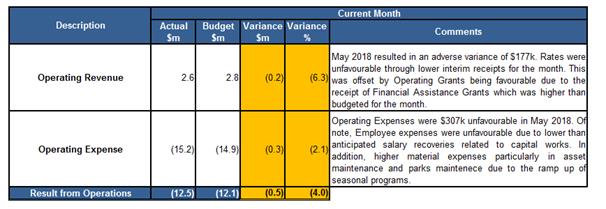
Capital Program
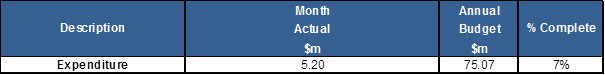
OVERALL COMMENTS ON YEAR-TO-DATE (YTD) FIGURES
Result from Operations
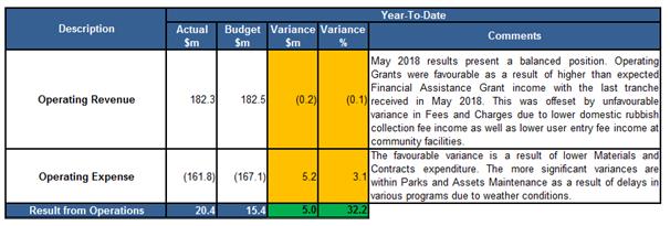
Capital Program Progress

Investment Portfolio Performance
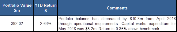
DETAILED ANALYSIS OF STATEMENT OF COMPREHENSIVE INCOME (ATTACHMENT 1)
Comments relating to the Statement of Comprehensive Income are provided under the following two sections:
a) Current month comparison of Actuals to Budgets, and
b) Year to date and end of year comparison of Actuals to Budgets.
a) Current Month Comparison of Actuals to Budgets
The below table highlights the operating performance for the May 2018 and identifies variances of Actual to Budget for each category of Revenue & Expense.
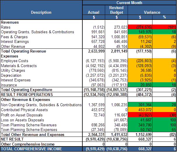
Total Comprehensive Income
An overall favourable variance of $668k resulted in May 2018. The key contributor to the variance relates to Developer Contributed Assets as a parcel of lots for $453k was recognised however budgets have been determined on a quarterly basis resulting in the favourable variance. However in current context capitalisation happens on and when practical completion is received.
Rates income was unfavourable due to lower than expected interim rates as well as Valuer General Rates reclassifications taking place leading to adjusted rates income in May.
Operating Grants were favourable $150k through the receipt of the final instalment for the Financial Assistance Grant which was higher than expected.
Town Planning Scheme income was higher than Budget due to higher than expected lot creations at the Alkimos/Eglinton district community development.
Non-Operating Grants were favourable due to the receipt of the Roads to Recovery Grant relating to next financial year. This was offset by a refund of the Black Spot grant received for the construction of a slip road on Marmion Ave as this project has now been ceased.
Employee costs resulted in an unfavourable variance through lower capital salary recoveries.
Materials and Contracts expenses were unfavourable through the continuing increase in Asset Maintenance and Parks Maintenance activities reflecting previously deferred works.
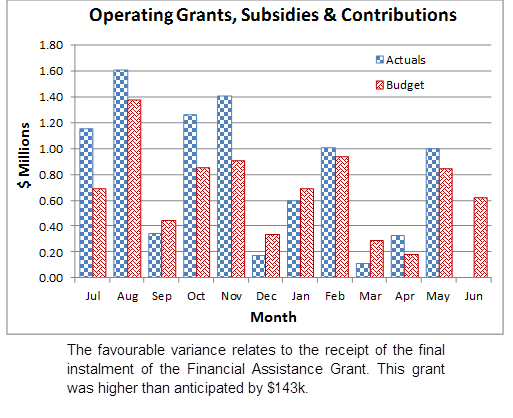
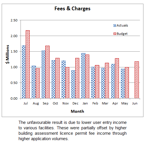
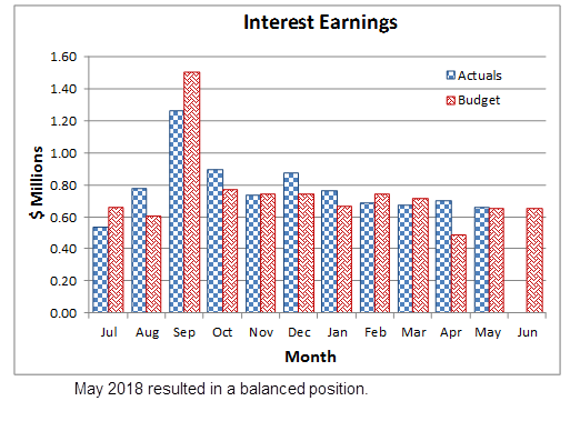
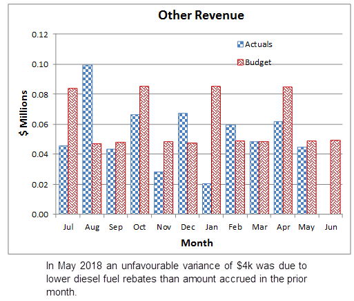
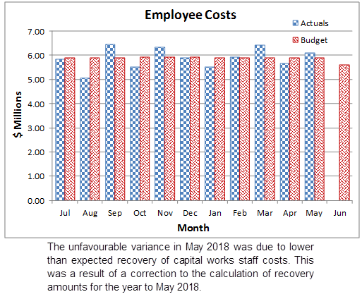
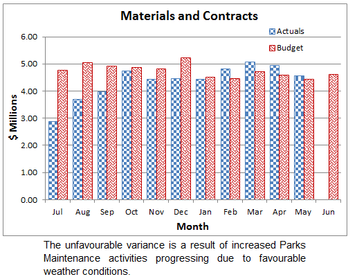
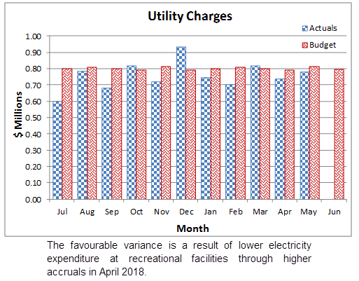
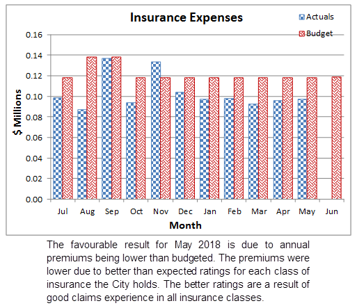
b) Year to Date and End of Year Comparison of Actuals to Budgets
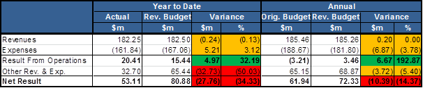
Details for the variances are outlined below.
Operating Revenues
Operating Grants, Subsidies and Contributions (Actual $8.9m, Revised Budget $7.5m)
The positive variance to May 2018 relates to a receipt from the Department of Fire and Emergency Services for Two Rocks Volunteer Bush Fire Brigade Facilities of $204k which was not anticipated. Additionally, the first three instalments of Financial Assistance Grants from the State Government were higher than budgeted by $572k. There was also a positive variance in HACC funding amounting to $127k as all funding for HACC had been received and the budget was allocated each month to June 2018.
Fees and Charges (Actual $13.0m, Revised Budget $14.3m)
The year to date unfavourable variance comprises a number of areas as follows;
· Domestic waste bins provided to residents have been lower than anticipated; these budgets include new residential development bin uptake requirements as well as additional bins requested by existing residents.
· Memberships at community recreation facilities have been lower than expected due to competitive market conditions. Advertising has been undertaken to encourage community participation and interest at the facilities in order to improve participation.
· Animal registration fee income has adverse to budget due to lower than expected volume of new and renewal registrations.
Operating Expenses
Materials and Contracts (Actual $48.0m, Revised Budget $52.3m)
The majority of the favourable variance relates to lower contract expenses in Parks Maintenance and Assets Maintenance although catch-up work is currently underway which will reduce this variance by June 2018. The contract expenses in these areas have been budgeted on an assumption of equal expenditure throughout the year. The seasonal impact has been reviewed and embedded in the 2018/19 budget.
Other variances to note include:
· Within Asset Maintenance a program relating to coastal maintenance at Mindarie Breakwater is yet to be undertaken. These works have been scheduled to commence in June 2018 and it is expected this will result in a material reduction in this variance.
· A year-to-date underspend in Conservation which is primarily related to weed control programs yet to be completed. Additionally some asbestos removal and tree works are still to take place at offset sites, these sites being land set aside to lessen impacts of urbanisation on the environment.
Whilst a majority of these variances are attributable to Parks and Assets maintenance it is noted that a number of service units that incur these costs are below Budget. For example Contract expenses for the following units make up $658k of the favourable variance: Advocacy and Economic Development, Waste Services, Infrastructure Capital Works, Customer and Information Services, Rates Services and Community Safety and Emergency Management. The favourable variance is due to delayed activities.
In addition to the above, refuse removal expenses were also lower than budgeted due to reduced waste tonnages for Mindarie Regional Council, and Consulting Fee Expenses were also favourable ($958k vs. $1.9m) reflecting lower requirements than anticipated.
Insurance Expenses (Actual $1.1m, Revised Budget $1.3m)
The favourable result for May 2018 is due to annual premiums being lower than budgeted reflecting claims experience in all insurance classes.
Other Revenue & Expenses
Non-Operating Grants, Subsidies and Contributions (Actual $8.2m, Revised Budget $11.8m)
The unfavourable variance is related to expected Grants yet to be received. These Grants include Roads to Recovery, Road Improvements, National Blackspot and State Blackspot. The majority of receipts are awarded on progress of capital works projects. Delays in projects can lead to delays in receipt of Grants.
Contributed Physical Assets (Actual $14.9m, Revised Budget $50.0m)
The year to May 2018 resulted in an adverse variance of $35.1m. Recognition of asset contributions is on practical completion which by nature is dependent on development progress.
Profit / Loss on Asset Disposals (Actual $1.6m, Revised Budget $1.3m)
The favourable variance is a result of Tamala Park Regional Council land sales exceeding that anticipated during the annual and mid-year budget development.
Town Planning Scheme (TPS) Revenues (Actual $20.3m, Revised Budget $17.9m)
The year to May 2018 produced a favourable result of $2.4m. The majority of the variance relates to Cell 9 where a receipt from a developer relating to the release of a bank guarantee was paid. Cell 4 lot yields were higher than expected which contributed to the favourable variance. Lot creation at the Alkimos/Eglinton developer contribution areas were higher than estimated contributing to the positive variance.
Town Planning Scheme (TPS) Expenses (Actual $12.5m, Revised Budget $15.6m)
TPS Expenses resulted in a favourable variance to May 2018 of $3.1m. This is the result of lower than anticipated Developer Contribution Plan expenditure. Additionally there are some consultancy costs relating to Cell 9 which are yet to be finalised which has also contributed to the favourable variance.
STATEMENT OF FINANCIAL POSITION (Attachment 2)
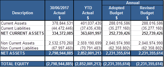
Net Current Assets
When compared to the opening position Net Current Assets have increased by $29.2m which is the combined impact of the timing of Rates receipts for 2017/18 and delayed Capital expenditure.
Current Receivables are mainly comprised of collectable Rates income of $15.5m. The majority of the remaining current receivables relates to Sundry Debtors of $1.5m and Emergency Services Levy collections of $1.4m.
Non-Current Assets
Year to date Non-Current Assets have increased by $26.6m from 2016/17 actuals. The movement is mainly the recognition of capital related works in progress.
Non-Current receivables largely relate to Deferred Pensioner Rebates of $2.5m being funds that cannot be collected until the Pensioner ceases to reside at the rateable property.
Non-Current Liabilities
Year to date Non-Current Liabilities have increased by $2.7m which is mainly attributed to a draw down on the new loan facility for the Yanchep DCP. The existing loan with the Western Australia Treasury Corporation remains unchanged and when combined with the new loan make up 98% of total Non-Current Liabilities.
FINANCIAL PERFORMANCE INDICATORS
The table below presents data on relevant financial ratios, comparing the minimum standard expected as per the Department of Local Government, Sport & Cultural Industries status at the beginning of the financial year, and year to date figures. An explanation of the purpose of each ratio is also provided together with commentary where a ratio does not meet the minimum standard (highlighted in Red). A green highlight is used where the minimum standard is met or exceeded.
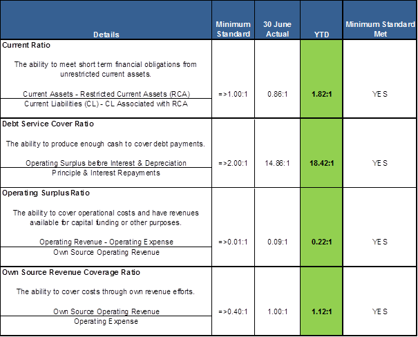
CAPITAL PROGRAM
The current status of the Capital Program is summarised below by Sub-Program category.
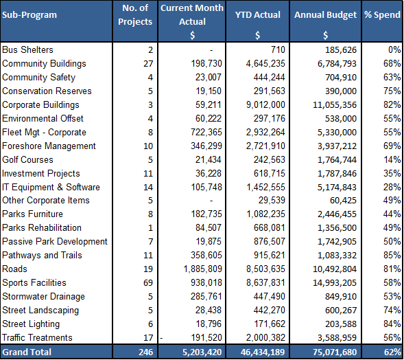
As at 31 May 2018 the City had spent $46.4m, which represents 62% of the revised $75.1m budget. The City had $13.7m of committed expenditure to the end of April. During the calendar month of May $5.2m was spent. Significant actual expenditure for works undertaken in May included:
· $1.19m Upgrade Mirrabooka Ave, Darch/Landsdale
· $507k Domestic Waste Vehicle Replacement
· $339k Coastal Protection Works, Quinns Rocks Beach
· $238k Wangara Industrial Drainage Upgrade Program
· $215k Light Vehicle Replacement
· $195k Park Assets Renewal Program
· $168k Banksia Grove Sports Ground
· $156k Road Resurfacing Program
· $129k New Pathways Program
· $118k Footpath on Rayner Drive
· $107k Marmion Avenue Dualling
Significant (LTD) commitments in the capital works program as at 31st May included:
· $3.92m Upgrade Mirrabooka Ave, Darch/Landsdale
· $984k Park Assets Renewal Program
· $671k Banksia Grove Sports Ground
· $604k Coastal Protection Works, Quinns Rocks Beach
· $463k Marmion Avenue Dualling
· $427k Domestic Waste Vehicle Replacement
· $425k Mary Lindsay Homestead Building (100%)
· $422k Civic Centre Extension
· $340k Light Vehicle Replacement
· $325k Motivation Drive, Wangara
· $295k WSSC Shed & Toilets
· $264k Butler North District Open Space
· $253k Grandis Park Skate Park
As at 31 May 2018, the City had spent $9.37m (75%) of the $12.44m adjusted carry forward budget from 2016/2017. Significant Actual (YTD) expenditure against carry forward projects include (% shown as Actual expenditure against Carry Forward budget only):
· $1.5m Domestic Waste Vehicle Replacement (100%)
· $860k Light Vehicle Replacement (100%)
· $589k Yanchep Surf Life Saving Club (100%)
· $577k Mary Lindsay Homestead Building (100%)
· $511k Mary Lindsay Homestead POS (100%)
· $416k Irrigation Infrastructure Replacement Program (100%)
· $354k Develop Industrial Estate – Neerabup (61%)
· $351k Quinns SLSC Community Centre (75%)
· $318k Installation of Entry Statements (100%)
· $269k Parks Asset Renewal Program (100%)
· $250k Enterprise Software Renewal Program (100%)
To further expand on the Capital Works Program information above, key capital projects are selected to be specifically reported on, which are itemised in the Top Capital Projects attachment to this report (Attachment 3).
INVESTMENT PORTFOLIO (Attachment 4)
In accordance with the Local Government (Financial Management) Regulations 1996 (and per the City’s Investment Policy), the City invests solely in the following highly secured investments in Australian Dollars:
1. Deposits with authorised deposit taking institutions and the Western Australian Treasury Corporation for a term not exceeding three years;
2. Bonds that are guaranteed by the Commonwealth Government or a State or Territory for a term not exceeding three years.
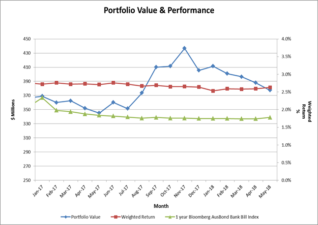
As at the end of May 2018, the City holds an investment portfolio (cash & cash equivalents) of $377.5m (Face Value), equating to $382.0m inclusive of accrued interest. The City’s year to date investment portfolio return has exceeded the Bank Bill index benchmark by 0.85% pa (2.63% pa vs. 1.78% pa), however it is noted that Interest Earnings were budgeted at a 2.75% yield.
All investments undertaken have been to provide the City with the most effective return whilst also adhering to the internal investment policy.
RATE SETTING STATEMENT (Attachment 5)
The Rate Setting Statement represents a composite view of the finances of the City, identifying the movement in the Surplus/(Deficit) based on the Revenues (excluding Rates), Expenses, Capital Works and Funding Movements, resulting in the Rating Income required. It is noted that the closing Surplus/(Deficit) will balance to the reconciliation of Net Current Assets Surplus/(Deficit) Carried Forward (detailed below).
Consultation
This document has been prepared in consultation with Responsible Officers for review and analysis.
Comment
The budget figures within this report incorporate approved budget amendments.
As per item 2 in Background, comments on material variances have been provided.
In reference to tables provided in the report, the following colours have been used to categorise three levels of variance:
· Green >+10%,
· Orange <+/-10%, and
· Red >-10%.
Statutory Compliance
This monthly financial report complies with Section 6.4 of the Local Government Act 1995 and Regulations 33A and 34 of the Local Government (Financial Management) Regulations 1996.
Strategic Implications
The proposal aligns with the following objective within the Strategic Community Plan 2017 – 2027:
“4 Civic Leadership
4.2 Good Governance
4.2.2 Provide responsible resource and planning management which recognises our significant future growth”
Risk Management Considerations
|
Risk Title |
Risk Rating |
|
Financial Management |
Moderate |
|
Accountability |
Action Planning Option |
|
Executive Management Team |
Manage |
The above risk relating to the issue contained within this report has been identified and considered within the City’s corporate risk register. Action plans have been developed to manage this risk to improve the existing management systems.
Policy Implications
· Accounting Policy
· Strategic Budget Policy
· Investment Policy
Financial Implications
As outlined above and detailed in Attachments 1 – 5
Voting Requirement
Absolute Majority
That Council;-
RECEIVES the Financial Activity Statements and commentaries on variances to YTD Budget for the period ended 31 May 2018, consisting of:
1. May 2018 YTD Actuals;
2. May 2018 YTD Statement of Financial Position and Net Current Assets; and
3. May 2018 YTD Material Financial Variance Notes
Attachments:
|
1⇩. |
Statement of Comprehensive Income May 2018 |
18/231875 |
Minuted |
|
2⇩. |
Statement of Financial Position May 2018 |
18/231878 |
Minuted |
|
3⇩. |
Top Projects 2017-18 - May 2018 - 20180508 |
16/151914[v27] |
Minuted |
|
4⇩. |
Investment Report May 2018 |
18/231881 |
Minuted |
|
5⇩. |
Rate Setting Statement May 2018 |
18/231876 |
Minuted |
Transactional Finance
File Ref: 1859 – 18/263267
Responsible Officer: Operations Manager Business & Finance
Disclosure of Interest: Nil
Attachments: Nil
Issue
Presentation to the Council of a list of accounts paid for the month of June 2018, including a statement as to the total amounts outstanding at the end of the month.
Background
Local Governments are required each month to prepare a list of accounts paid for that month and submit the list to the next Ordinary Meeting of the Council.
In addition, it must record all other outstanding accounts and include that amount with the list to be presented. The list of accounts paid and the total of outstanding accounts must be recorded in the minutes of the Council meeting.
Detail
The following is the Summary of Accounts paid in June 2018
|
Funds |
Vouchers |
Amount |
|
Director Corporate Services Advance A/C Accounts Paid – June 2018 Cheque Numbers EFT Document Numbers TOTAL ACCOUNTS PAID
Less Cancelled Cheques Town Planning Scheme Manual Journal RECOUP FROM MUNICIPAL FUND |
113215 - 113610 3240 - 3263 |
$649,021.18 $13,944,227.34 $14,593,248.52
($14,002.27) ($14,500.01) ($629,119.62) $13,935,626.62 |
|
Municipal Fund – Bank A/C Accounts Paid – June 2018 Municipal Recoup Direct Payments Payroll – Direct Debits TOTAL ACCOUNTS PAID |
|
$13,935,626.62 $26,052.60 $3,614,862.26 $17,576,541.48 |
|
Town Planning Scheme Accounts Paid – June 2018 Cell 1 Cell 2 Cell 3 Cell 4 Cell 5 Cell 6 Cell 7 Cell 8 Cell 9 TOTAL ACCOUNTS PAID |
|
$1,333.34 $2,583.34 $1,333.34 $1,333.34 $1,645.83 $2,020.83 $1,333.33 $1,333.33 $1,583.33 $14,500.01 |
At the close of June 2018 outstanding creditors amounted to $4,227,625.76.
Consultation
Nil
Comment
The list of payments (cheques and electronic transfers) and the end of month total of outstanding creditors for the month of June 2018 is presented to the Council for information and recording in the minutes of the meeting, as required by the Local Government (Financial Management) Regulations 1996.
Statutory Compliance
Regulation 13(1) of the Local Government (Financial Management) Regulations 1996 requires a local government to list the accounts paid each month and total all outstanding creditors at the month end and present such information to the Council at its next Ordinary Meeting after each preparation. A further requirement of this Section is that the prepared list must be recorded in the minutes of the Council meeting.
Strategic Implications
The proposal aligns with the following objective within the Strategic Community Plan 2017 – 2027:
“4 Civic Leadership
4.3 Progressive Organisation
4.3.2 Ensure excellence in our customer service”
Risk Management Considerations
There are no existing Strategic or Corporate risks within the City's existing risk registers which relate to the issues contained in this report.
Policy Implications
Nil
Financial Implications
Nil
Voting Requirements
Simple Majority
|
That Council RECEIVES the list of payments drawn for the month of June 2018, as summarised below:-
|
|||||||||||||||||||||||||||||||||||||||||||||||||||||||||||||||||||||||||||||||||||||||||||||||||||||||||||||||||||||||||||||||||||||||||||||||||||||||||||||||||||||||||||||||||||||||||||||||||||||||||||||||||||||||||||||||||||||||||||||||||||||||||||||||||||||||||||||||||||||||||||||||||||||||||||||||||||||||||||||||||||||||||||||||||||||||||||||||||||||||||||||||||||||||||||||||||||||||||||||||||||||||||||||||||||||||||||||||||||||||||||||||||||||||||||||||||||||||||||||||||||||||||||||||||||||||||||||||||||||||||||||||||||||||||||||||||||||||||||||||||||||||||||||||||||||||||||||||||||||||||||||||||||||||||||||||||||||||||||||||||||||||||||||||||||||||||||||||||||||||||||||||||||||||||||||||||||||||||||||||||||||||||||||||||||||||||||||||||||||||||||||||||||||||||||||||||||||||||||||||||||||||||||||||||||||||||||||||||||||||||||||||||||||||||||||||||||||||||||||||||||||||||||||||||||||||||||||||||||||||||||||||||||||||||||||||||||||||||||||||||||||||||||||||||||||||||||||||||||||||
Council & Corporate Support
File Ref: 2855V02 – 18/260359
Responsible Officer: Director Corporate Strategy & Performance
Disclosure of Interest: Nil
Attachments: 1
Issue
To consider requests for sponsorships, donations and waiver of fees in accordance with the City’s Donations, Sponsorships and Waiver of Fees and Charges Policy (Policy).
Background
The Policy requires applications over $500 from individuals and organisations to be determined by Council. Consequently a report is prepared for Council meetings, coinciding with a period where applications of this nature have been received.
With respect to requests for sponsorships, the Policy specifies that for National Events the amount provided will be $200.00 per individual, capped at $600.00 per team, and for International Events the amount provided is $500.00 per individual capped at $1,500.00 per team. Schools are capped at $2,000.00 per school per financial year.
Detail
During this period, the City has received eleven sponsorship requests, two community donation requests and one request for a waiver of fees and charges, which are summarised as follows. Copies of the full applications are available from Council Support upon request.
Comment
Sponsorship Donations
|
Applicant 1 – Joondalup Athletics Centre |
|
|
Name of Individual/s
|
Samuel Holroyd and Isabel Strover |
|
Reside in City of Wanneroo 18years of age or under |
Yes Yes |
|
Event Details |
26th International Athletics Championship, Singapore, 9 – 17 July 2018 |
|
Commitment to providing a written report regarding the event |
Yes |
|
Commitment to acknowledgement of the City of Wanneroo |
Yes |
|
Eligibility Level |
International |
|
Comments
|
As per the policy $500.00 per individual (capped at $1500 per team) |
|
Recommendation
|
APPROVE a request for sponsorship in the sum of $1,000.00 to Joondalup Athletics Centre for the participation of Samuel Holroyd and Isabel Strover at the 26th International Athletics Championship to be held in Singapore from 9 – 17 July 2018. |
|
Reason |
This request is in accordance with Council’s Policy |
|
Applicant 2 – Ridgewood Little Athletics Centre |
|
|
Name of Individual/s
|
Emilio Estrella and Jordan Woodman |
|
Reside in City of Wanneroo 18years of age or under |
Yes Yes |
|
Event Details |
26th International Athletics Championship, Singapore, 9 – 17 July 2018 |
|
Commitment to providing a written report regarding the event |
Yes |
|
Commitment to acknowledgement of the City of Wanneroo |
Yes |
|
Eligibility Level |
International |
|
Comments |
As per the policy $500.00 per individual (capped at $1500 per team) |
|
Recommendation
|
APPROVE a request for sponsorship in the sum of $1,000.00 to Ridgewood Little Athletics Centre for the participation of Emilio Estrella and Jordan Woodman at the 26th International Athletics Championship to be held in Singapore from 9 – 17 July 2018. |
|
Reason |
This request is in accordance with Council’s Policy |
|
Applicant 3 – Perth Metro North Intermediate League |
|
|
Name of Individual/s
|
Tyler Paul, Jayden Paul and Jacob Santich |
|
Reside in City of Wanneroo 18years of age or under |
Yes Yes |
|
Event Details |
2018 Little League Intermediate World Series, California, USA, 29 July – 5 August 2018 |
|
Commitment to providing a written report regarding the event |
Yes |
|
Commitment to acknowledgement of the City of Wanneroo |
Yes |
|
Eligibility Level |
International |
|
Comments |
As per the policy $500.00 per individual (capped at $1500 per team) |
|
Recommendation
|
APPROVE a request for sponsorship in the sum of $1,500.00 to Perth Metro North Intermediate League for the participation of Tyler Paul, Jayden Paul and Jacob Santich at the 2018 Little League Intermediate World Series to be held in California USA from 29 July to 5 August 2018. |
|
Reason |
This request is in accordance with Council’s Policy |
|
Applicant 4 – School Sport Western Australia Inc |
|
|
Name of Individual/s
|
Boys Team – Cameron Quirk, Bailey Taig and Aiden Arthy Girls Team – Nadia Godley, Mackenzie Scholes and Madison Scholes Mixed Team – Chloe Reeve and Josh Reeve |
|
Reside in City of Wanneroo 18years of age or under |
Yes Yes |
|
Event Details |
2018 School Sport Australia Cross Country, Brisbane Qld, 23 – 27 August 2018 |
|
Commitment to providing a written report regarding the event |
Yes |
|
Commitment to acknowledgement of the City of Wanneroo |
Yes |
|
Eligibility Level |
National |
|
Comments |
As per the policy $200.00 per individual (capped at $600 per team to a maximum of four teams per event). |
|
Recommendation
|
APPROVE a request for sponsorship in the sum of $1,400.00 to School Sport Western Australia Inc for the participation of Boys Team – Cameron Quirk, Bailey Taig and Aiden Arthy; Girls Team – Nadia Godley, Mackenzie Scholes and Madison Scholes and Mixed Team – Chloe Reeve and Josh Reeve at the 2018 School Sport Australia Cross Country to be held in Brisbane Qld from 23 – 27 August 2018. |
|
Reason |
This request is in accordance with Council’s Policy |
|
Applicant 5 – School Sport Western Australia Inc |
|
|
Name of Individual/s
|
Boys 12s – Banjo Fitch, Stevan Merenda and Trey Sandon Girls 12s – Jasmine Kirby and Susan Fahnbulleh |
|
Reside in City of Wanneroo 18years of age or under |
Yes Yes |
|
Event Details |
2018 School Sport Australia Basketball, Darwin NT, 10 – 18 August 2018 |
|
Commitment to providing a written report regarding the event |
Yes |
|
Commitment to acknowledgement of the City of Wanneroo |
Yes |
|
Eligibility Level |
National |
|
Comments |
As per the policy $200.00 per individual (capped at $600 per team to a maximum of four teams per event). |
|
Recommendation
|
APPROVE a request for sponsorship in the sum of $1,000.00 to School Sport Western Australia Inc for the participation of Boys 12s – Banjo Fitch, Stevan Merenda and Trey Sandon; and Girls 12s – Jasmine Kirby and Susan Fahnbulleh at the 2018 School Sport Australia Basketball to be held in Darwin NT from 10 – 18 August 2018. |
|
Reason |
This request is in accordance with Council’s Policy |
|
Applicant 6 – School Sport Western Australia Inc |
|
|
Name of Individual/s
|
Hannah Sivic, Xavier Collins, Owen Brown, Brayden Smith and Jacob Smith |
|
Reside in City of Wanneroo 18years of age or under |
Yes Yes |
|
Event Details |
2018 School Sport Australia Swimming, Hobart Tas, 24 – 31 July 2018 |
|
Commitment to providing a written report regarding the event |
Yes |
|
Commitment to acknowledgement of the City of Wanneroo |
Yes |
|
Eligibility Level |
National |
|
Comments |
As per the policy $200.00 per individual (capped at $600 per team to a maximum of four teams per event). |
|
Recommendation
|
APPROVE a request for sponsorship in the sum of $600.00 to School Sport Western Australia Inc for the participation of Hannah Sivic, Xavier Collins, Owen Brown, Brayden Smith and Jacob Smith at the 2018 School Sport Australia Swimming to be held in Hobart Tas from 10 – 18 August 2018. |
|
Reason |
This request is in accordance with Council’s Policy |
|
Applicant 7 – School Sport Western Australia Inc |
|
|
Name of Individual/s
|
Jayden Crane, Jacob Evitt, Zac Fleiner, Saverio Marafioti and Lochlan Paton |
|
Reside in City of Wanneroo 18years of age or under |
Yes Yes |
|
Event Details |
2018 School Sport Australia AFL 15s, Adelaide SA, 21 - 29 July 2018 |
|
Commitment to providing a written report regarding the event |
Yes |
|
Commitment to acknowledgement of the City of Wanneroo |
Yes |
|
Eligibility Level |
National |
|
Comments |
As per the policy $200.00 per individual (capped at $600 per team to a maximum of four teams per event). |
|
Recommendation
|
APPROVE a request for sponsorship in the sum of $600.00 to School Sport Western Australia Inc for the participation of Jayden Crane, Jacob Evitt, Zac Fleiner, Saverio Marafioti and Lochlan Paton at the 2018 School Sport Australia AFL 15s to be held in Adelaide SA from 21 – 29 July 2018. |
|
Reason |
This request is in accordance with Council’s Policy |
|
Applicant 8 – School Sport Western Australia Inc |
|
|
Name of Individual/s
|
Meghan Hulsman, Grace Monterio and Sophia Neal |
|
Reside in City of Wanneroo 18years of age or under |
Yes Yes |
|
Event Details |
2018 Secondary Football Team, Shepparton Vic, 24 – 31 August 2018 |
|
Commitment to providing a written report regarding the event |
Yes |
|
Commitment to acknowledgement of the City of Wanneroo |
Yes |
|
Eligibility Level |
National |
|
Comments |
As per the policy $200.00 per individual (capped at $600 per team to a maximum of four teams per event). |
|
Recommendation
|
APPROVE a request for sponsorship in the sum of $600.00 to School Sport Western Australia Inc for the participation of Meghan Hulsman, Grace Monterio and Sophia Neal at the 2018 Secondary Football Team to be held in Shepparton Vic from 24 – 31 August 2018. |
|
Reason |
This request is in accordance with Council’s Policy |
|
Applicant 9 – DaKidZ Inc |
|
|
Name of Individual/s
|
Zak Rolton, Chase Rolton, Tayla Russell, Eve Basson, Will Basson, Bianca Dinardo, Ashley Brunton, Isabella Long, Lewis Long, Courtney heath, Makenna Martin, Hannah Martin, Meg Lidell, Hailey Hann, Tia Nimmo, Mia Seaton and Jaidyn Brunyee |
|
Reside in City of Wanneroo 18years of age or under |
Yes Yes |
|
Event Details |
GTB National Dance Championships, Singapore, 26 November to 4 December 2018 |
|
Commitment to providing a written report regarding the event |
Yes |
|
Commitment to acknowledgement of the City of Wanneroo |
Yes |
|
Eligibility Level |
International |
|
Comments |
As per the policy $500.00 per individual (capped at $1500 per team) |
|
Recommendation
|
APPROVE a request for sponsorship in the sum of $1,500.00 to DaKidZ Inc for the participation of Zak Rolton, Chase Rolton, Tayla Russell, Eve Basson, Will Basson, Bianca Dinardo, Ashley Brunton, Isabella Long, Lewis Long, Courtney heath, Makenna Martin, Hannah Martin, Meg Lidell, Hailey Hann, Tia Nimmo, Mia Seaton and Jaidyn Brunyee at the GTB National Dance Championships to be held in Singapore from 26 November to 4 December 2018. |
|
Reason |
This request is in accordance with Council’s Policy |
|
Applicant 10 – Ashdale Secondary College |
|
|
Name of Individual/s
|
Yasi Bhudia, Hannah Demos, Tanisha Dhu, Jade Ellis, Brianna Fisher, Kelsey Hazzard, Caitlin Jones, Layla Lopez, Hannah McCarthy, Alicia McGillivray, Olivia Paolella, Rani Pearce, Stephanie Voigt, Alexander Walker, Dapanee Wongnak and Ashleigh Woods |
|
Reside in City of Wanneroo 18years of age or under |
Yes Yes |
|
Event Details |
Fiji Netball Tour, Lautoka, Fiji, 6 – 14 December 2018 |
|
Commitment to providing a written report regarding the event |
Yes |
|
Commitment to acknowledgement of the City of Wanneroo |
Yes |
|
Eligibility Level |
Clause 5.4 of Policy |
|
Comments |
As per the policy under clause 5.4 “Funding will be to a maximum of $2,000.00 per school per financial year to support students attending events.” |
|
Recommendation
|
APPROVE a request for sponsorship in the sum of $2,000.00 to Ashdale Secondary College for the participation of Yasi Bhudia, Hannah Demos, Tanisha Dhu, Jade Ellis, Brianna Fisher, Kelsey Hazzard, Caitlin Jones, Layla Lopez, Hannah McCarthy, Alicia McGillivray, Olivia Paolella, Rani Pearce, Stephanie Voigt, Alexander Walker, Dapanee Wongnak and Ashleigh Woods at the Fiji Netball Tour to be held in Lautoka, Fiji from 6 – 14 December 2018. |
|
Reason |
This request is in accordance with Council’s Policy |
|
Applicant 11 – Football West |
|
|
Name of Individual/s
|
U14 Team - Monique Prinsloo U15 Team - Alix Davies, Yanka Stobbe, Jennifer McGlynn and Taneesha Baker |
|
Reside in City of Wanneroo 18years of age or under |
Yes Yes |
|
Event Details |
Westfield Girls National Youth Championships, Coffs Harbour, NSW, 16 – 20 July 2018 |
|
Commitment to providing a written report regarding the event |
Yes |
|
Commitment to acknowledgement of the City of Wanneroo |
Yes |
|
Eligibility Level |
National |
|
Comments |
As per the policy $200.00 per individual (capped at $600 per team to a maximum of four teams per event). |
|
Recommendation
|
APPROVE a request for sponsorship in the sum of $800.00 to Football West for the participation of U14 Team - Monique Prinsloo and U15 Team - Alix Davies, Yanka Stobbe, Jennifer McGlynn and Taneesha Baker at the Westfield Girls National Youth Championships held in Coffs Harbour NSW from 16 – 20 July 2018. |
|
Reason |
This request is in accordance with Council’s Policy |
Community Group Donations
|
Applicant 12 – Badminton Association of Western Australia |
|
|
Request amount |
$3,885.00 |
|
Description of request |
Waiver of fees request for hire of the Kingsway indoor Stadium to hold the 2018 Asia Pacific Team Championships & Australian Junior International from 10-16 September 2018. |
|
Criteria |
Evaluation |
|
Potential for income generation |
There is a player entry fee but no charge for spectators |
|
Status of applicant organisation |
Not for profit |
|
Exclusivity of the event or project |
Under 19 badminton players from the Asia and Pacific Regions |
Alignment with Council’s existing philosophies, values and strategic direction |
Objective 1.1 – Healthy and active people – Create opportunities that encourage community wellbeing and active and healthy lifestyles |
|
Alternative funding sources available or accessed by the organisation |
$4,500.00 |
|
Contribution to the event or activity made by the applicant or organisation |
$10,000.00 plus $9,000 in kind contribution |
|
Previous funding assistance provided to the organisation by the City |
Through Community Funding rounds – CD05-06/02 $2,500.00 CD01-12/09 $1,500.00 CD03-05/11 $1,500.00 CD03-11/11 $1,000.00 CD02-05/12 $1,400.00 CD03-04/13 $642.50 CD05-05/14 $500.00 Through Council CS03-07/14 Nil CS05-08/17 $2,730.55 |
|
Commitment to acknowledge the City of Wanneroo |
Yes |
|
Comments |
Clause 2.7 of the Donations, Sponsorships and Waiver of Fees and Charges Policy outlines that "requests that have the potential for income generation or profit or where an entry fee is being charged (excluding a gold coin donation)" are excluded. Whilst entry to watch the event is free, the group are charging teams to participate. |
|
Recommendation |
NOT APPROVE a request for a donation for 50% waiver of fees in the sum of $3,885.00 to the Badminton Association of Western Australia for hire of the Kingsway Indoor Stadium for the 2018 Asia Pacific Team Championships & Australian Junior International to be held from 10 – 16 September 2018. |
|
Reason |
The request does not satisfy the criteria of the policy. |
|
Applicant 13 – Organization of African Communities of WA Inc |
|
|
Request amount |
$5,000.00 |
|
Description of request |
Donation to sponsor an awards category and assist with running of the WA African Community Awards Night to be held at the Novotel, Perth on 1 September 2018 (see Attachment 1). |
|
Criteria |
Evaluation |
|
Potential for income generation |
An amount is being charged for ticket entry. This is a fund raising event with sponsorship packages ranging from $80 to $5,000 (see Attachment 1). |
|
Status of applicant organisation |
Not stated |
|
Exclusivity of the event or project |
Members of the WA African community, African and state government representatives and corporate stakeholders with interests in Africa and the WA African community and anyone from the community. |
Alignment with Council’s existing philosophies, values and strategic direction |
Objective 1.1 – Healthy and active people – Create opportunities that encourage community wellbeing and active and healthy lifestyles |
|
Alternative funding sources available or accessed by the organisation |
$13,000.00 |
|
Contribution to the event or activity made by the applicant or organisation |
$10,000.00 plus $3,000 in kind contribution |
|
Previous funding assistance provided to the organisation by the City |
CS04-12/16 $1,071.00 OAC Football Tournament
|
|
Commitment to acknowledge the City of Wanneroo |
Yes |
|
Comments |
Clause 2.7 of the Donations, Sponsorships and Waiver of Fees and Charges Policy outlines that "requests that have the potential for income generation or profit or where an entry fee is being charged (excluding a gold coin donation)" are excluded. Clause 2.9 states “Fund raising activities, for example, prizes for quiz nights, fetes and generic fundraising campaigns from individuals or National Charities, unless it can be demonstrated that the events aims & objectives are targeted primarily at the City’s community as a whole” are excluded. |
|
Recommendation |
NOT APPROVE a request for a donation in the sum of $5,000.00 to the Organization of African Communities of WA Inc to sponsor an awards category and assist with running of the WA African Community Awards Night to be held at the Novotel, Perth on 1 September 2018. |
|
Reason |
The request does not satisfy the criteria of the policy. |
|
Applicant 14 – Wanneroo Central Bush Fire Brigade |
|
|
Request amount |
$2,000.00 |
|
Description of request |
Donation to pay team registration fees, team uniforms, accommodation, transport and equipment to support 3 teams competing in the Australasian Police & Emergency Services Games to be held in Halls Head, WA from 28 October to 3 November 2018. |
|
Criteria |
Evaluation |
|
Potential for income generation |
Nil |
|
Status of applicant organisation |
Registered Charity |
|
Exclusivity of the event or project |
General public can attend as viewers, only Brigade members can compete on behalf of CoW (teams are from Wanneroo Central, Quinns Rocks, Wanneroo Support and Two Rocks Bushfire Brigades) |
Alignment with Council’s existing philosophies, values and strategic direction |
Objective 1.1 – Healthy and active people – Create opportunities that encourage community wellbeing and active and healthy lifestyles |
|
Alternative funding sources available or accessed by the organisation |
$600.00 |
|
Contribution to the event or activity made by the applicant or organisation |
$1,200 |
|
Previous funding assistance provided to the organisation by the City |
CS03-09/16 - $2,000.00 for 2016 Australian Police and Emergency Services Games, Sunshine Coast Qld MN01-03/12 - $5,000 for 50th Anniversary Celebration $9,000 for the City of Wanneroo Volunteer Bush Fire Brigades End of Season Dinner |
|
Commitment to acknowledge the City of Wanneroo |
Yes |
|
Comments |
The Donations, Sponsorships & Waiver of Fees and Charges Policy supports travel for juniors 18 years of age and under. This group are adults, making them ineligible to be considered under the sponsorship program. The City has provided $9,000 within its current budget to fund the City of Wanneroo Volunteer Bush Fire Brigades End of Season Dinner that will be held in August 2018. It is important to note that this dinner is organised on behalf of all of the brigades and this current application is also submitted to support all of the volunteer brigades. However, even with a distribution of that funding across all the brigades, this group are already receiving financial assistance this financial year, and are therefore ineligible for further funding in accordance with Clause 2.4 of the Donations, Sponsorships & Waiver of Fees and Charges Policy. The City of Wanneroo also provides funding from its budget throughout the year to financially support the Wanneroo Central Bush Fire Brigade for operational purchase requirements. |
|
Recommendation |
NOT APPROVE a request for a donation in the sum of $2,000.00 towards the Wanneroo Central Bush Fire Brigade for assistance with team registration fees, team uniforms, accommodation, transport and equipment to support 3 teams competing in the Australasian Police & Emergency Services Games to be held in Halls Head, WA from 28 October to 3 November 2018. |
|
Reason |
This request does not satisfy the criteria of the policy. |
Statutory Compliance
Nil
Strategic Implications
The proposal aligns with the following objective within the Strategic Community Plan 2017 – 2027:
“1 Society
1.1 Healthy and Active People
1.1.1 Create opportunities that encourage community wellbeing and active and healthy lifestyles”
Risk Management Considerations
There are no existing Strategic or Corporate risks within the City's existing risk registers which relate to the issues contained in this report.
Policy Implications
The Policy states that sponsorship applications for attendance at National Events will be capped at $600.00 per team (up to four teams) and Regional or State capped at $600 per club. International events will be capped at $1,500.00 per team and schools capped at $2,000.00 per school per financial year.
Financial Implications
|
Budget 2018/2019 |
|
$100 000.00 |
|
Amount expended to date (as at 6/7/18) |
|
0 |
|
Balance |
|
$100 000.00 |
|
Total of requests for this round: Donations (in this report):
Total this Round (recommended) |
$22,385.00 |
$12,000.00 |
|
BALANCE |
|
$88,000.00 |
It is noted that there are a higher number than average requests for sponsorships and donations, due to the start of the new budget for this financial year.
Voting Requirements
Simple Majority
That Council:-
1. APPROVE a request for sponsorship in the sum of $1,000.00 to Joondalup Athletics Centre for the participation of Samuel Holroyd and Isabel Strover at the 26th International Athletics Championship to be held in Singapore from 9 – 17 July 2018;
2. APPROVE a request for sponsorship in the sum of $1,000.00 to Ridgewood Little Athletics Centre for the participation of Emilio Estrella and Jordan Woodman at the 26th International Athletics Championship to be held in Singapore from 9 – 17 July 2018;
3. APPROVE a request for sponsorship in the sum of $1,500.00 to Perth Metro North Intermediate League for the participation of Tyler Paul, Jayden Paul and Jacob Santich at the 2018 Little League Intermediate World Series to be held in California USA from 29 July to 5 August 2018;
4. APPROVE a request for sponsorship in the sum of $1,400.00 to School Sport Western Australia Inc for the participation of Boys Team – Cameron Quirk, Bailey Taig and Aiden Arthy; Girls Team – Nadia Godley, Mackenzie Scholes and Madison Scholes and Mixed Team – Chloe Reeve and Josh Reeve at the 2018 School Sport Australia Cross Country to be held in Brisbane Qld from 23 – 27 August 2018;
5. APPROVE a request for sponsorship in the sum of $1,000.00 to School Sport Western Australia Inc for the participation of Boys 12s – Banjo Fitch, Stevan Merenda and Trey Sandon; and Girls 12s – Jasmine Kirby and Susan Fahnbulleh at the 2018 School Sport Australia Basketball to be held in Darwin NT from 10 – 18 August 2018;
6. APPROVE a request for sponsorship in the sum of $600.00 to School Sport Western Australia Inc for the participation of Hannah Sivic, Xavier Collins, Owen Brown, Brayden Smith and Jacob Smith at the 2018 School Sport Australia Swimming to be held in Hobart Tas from 10 – 18 August 2018;
7. APPROVE a request for sponsorship in the sum of $600.00 to School Sport Western Australia Inc for the participation of Jayden Crane, Jacob Evitt, Zac Fleiner, Saverio Marafioti and Lochlan Paton at the 2018 School Sport Australia AFL 15s to be held in Adelaide SA from 21 – 29 July 2018;
8. APPROVE a request for sponsorship in the sum of $600.00 to School Sport Western Australia Inc for the participation of Meghan Hulsman, Grace Monterio and Sophia Neal at the 2018 Secondary Football Team to be held in Shepparton Vic from 24 – 31 August 2018;
9. APPROVE a request for sponsorship in the sum of $1,500.00 to DaKidZ Inc for the participation of Zak Rolton, Chase Rolton, Tayla Russell, Eve Basson, Will Basson, Bianca Dinardo, Ashley Brunton, Isabella Long, Lewis Long, Courtney heath, Makenna Martin, Hannah Martin, Meg Lidell, Hailey Hann, Tia Nimmo, Mia Seaton and Jaidyn Brunyee at the GTB National Dance Championships to be held in Singapore from 26 November to 4 December 2018;
10. APPROVE a request for sponsorship in the sum of $2,000.00 to Ashdale Secondary College for the participation of Yasi Bhudia, Hannah Demos, Tanisha Dhu, Jade Ellis, Brianna Fisher, Kelsey Hazzard, Caitlin Jones, Layla Lopez, Hannah McCarthy, Alicia McGillivray, Olivia Paolella, Rani Pearce, Stephanie Voigt, Alexander Walker, Dapanee Wongnak and Ashleigh Woods at the Fiji Netball Tour to be held in Lautoka, Fiji from 6 – 14 December 2018;
11. APPROVE a request for sponsorship in the sum of $800.00 to Football West for the participation of U14 Team - Monique Prinsloo and U15 Team - Alix Davies, Yanka Stobbe, Jennifer McGlynn and Taneesha Baker at the Westfield Girls National Youth Championships held in Coffs Harbour NSW from 16 – 20 July 2018;
12. NOT APPROVE a request for a donation for 50% waiver of fees in the sum of $3,385.00 to the Badminton Association of Western Australia for hire of the Kingsway Indoor Stadium for the 2018 Asia Pacific Team Championships & Australian Junior International to be held from 10 – 16 September 2018;
13. NOT APPROVE a request for a donation in the sum of $5,000.00 to the Organization of African Communities of WA Inc to sponsor an awards category and assist with running of the WA African Community Awards Night to be held at the Novotel, Perth on 1 September 2018; and
14. NOT APPROVE a request for a donation in the sum of $2,000.00 towards the Wanneroo Central Bush Fire Brigade for assistance with team registration fees, team uniforms, accommodation, transport and equipment to support 3 teams competing in the Australasian Police & Emergency Services Games to be held in Halls Head, WA from 28 October to 3 November 2018.
Attachments:
|
1⇩. |
OAC Gala Night |
18/276241 |
|
Chief Executive Office
CE01-07/18 Amendment to Delegation – Food Act 2008 – Appointment of Authorised and Designated Officers
File Ref: 9167V02 – 18/250855
Responsible Officer: Executive Manager Governance and Legal
Disclosure of Interest: Nil
Attachments: 1
Issue
To consider an amendment to the delegation adopted by Council on 26 June 2018 under the Food Act 2008 – Appointment of Authorised and Designated Officers as set out in Attachment 1.
Background
As part of the legislative annual delegated authority review, amendments were proposed to the delegation relating to the appointment of Authorised and Designated Officers under the Food Act 2008 (the Act). The amendments proposed were as a result of a review of the delegation against the Western Australian Local Government Association’s model template register and the Food Act 2008 legislation.
Detail
The Act allows for the delegation of functions to be conferred on a local government subject to relevant Department of Health CEO Guidelines, as amended from time to time.
The amendments proposed and adopted at the Council meeting of 26 June 2018 related to the rewording of the delegation to be consistent with the provisions of the legislation. The Act provides for a delegation to appoint authorised and designated officers as opposed to being a direct appointment by Council.
Attachment 1 proposes to effect the necessary changes to the delegation as there are no powers of sub-delegation provided for under the Act or the Food Regulations 2009, Council is requested to confer the delegation to the Chief Executive Officer as well as the Director Planning and Sustainability and the Manager Health and Compliance.
In addition a new condition on the delegation is proposed to meet legislative requirements and a previous condition is requested to be reinstated:-
“In accordance with s.118(3)(b), this delegation is subject to relevant Department of Health CEO Guidelines, as amended from time to time; and
The power to prosecute any person is only exercised by agreement of the Manager Health & Compliance and Director Planning & Sustainability in consultation with advice from the Executive Manager Governance & Legal.
Consultation
Nil
Comment
The proposed amendments as set out in Attachment 1 align with the requirements of the Act.
Statutory Compliance
Section 118 of the Food Act states:
(2) A function conferred or imposed on an enforcement agency may be delegated —
(a) if the enforcement agency is the CEO — in accordance with section 117; or
(b) if the enforcement agency is a local government or a person or body, or a person or body within a class of persons or bodies, prescribed by the regulations — subject to subsections (3) and (4), in accordance with the regulations.
Strategic Implications
The proposal aligns with the following objective within the Strategic Community Plan 2017 – 2027:
“4 Civic Leadership
4.2 Good Governance
4.2.1 Provide transparent and accountable governance and leadership”
Risk Management Considerations
|
Risk Title |
Risk Rating |
|
CO-C01 Compliance Framework |
Moderate |
|
Accountability |
Action Planning Option |
|
Executive Manager Governance & Legal |
Manage |
The above risk relating to the issue contained within this report has been identified and considered within the City’s Corporate risk register. Action plans have been developed to manage this risk to support existing management systems.
Policy Implications
Nil
Financial Implications
Nil
Voting Requirements
Simple Majority
That Council ADOPTS the amendments to the delegation Food Act 2008 – Appointment of Authorised and Designated Officers as set out in Attachment 1.
Attachments:
|
1⇩. |
Food Act 2008 - Appointment of Authorised and Designated Officers - Amendments |
18/254110 |
Minuted |
CITY OF WANNEROO Agenda OF Ordinary Council Meeting 24 July, 2018 369
File Ref: 26321V02 – 18/251344
Responsible Officer: Executive Manager Governance and Legal
Disclosure of Interest: Nil
Attachments: Nil
Issue
To consider extending adopted Council Policy document review dates for the Crossover Subsidy Policy and Local Planning Policy 4.4: Urban Water Management.
Background
Council at its 29 May 2018 Council meeting resolved to extend the adopted review dates of a number of policies that were overdue for review as the extension of the review dates posed a minimal risk to the City in their current form.
Detail
During the implementation of Council resolution CE08-05/18, it was noted that the review dates adopted for the Crossover Subsidy Policy and Local Planning Policy 4.4: Urban Water Management were incorrectly recorded as 2018 instead of 2019.
Consultation
Nil
Comment
There is minimal risk to the City in applying the policies in their current forms.
Statutory Compliance
Nil
Strategic Implications
The proposal aligns with the following objective within the Strategic Community Plan 2017 – 2027:
“4 Civic Leadership
4.2 Good Governance
4.2.1 Provide transparent and accountable governance and leadership”
Risk Management Considerations
|
Risk Title |
Risk Rating |
|
Decision Making |
Low |
|
Accountability |
Action Planning Option |
|
Chief Executive Officer |
Manage |
The above risk relating to the issue contained within this report has been identified and considered within the City’s Corporate risk register. The review and repeal of the policies as set out in this report will support existing management systems.
Policy Implications
Nil
Financial Implications
Nil
Voting Requirements
Simple Majority
That Council ADOPTS the amended review date of 30 June 2019 for the Crossover Subsidy Policy and the Local Planning Policy 4.4: Urban Water Management.
Item 9 Motions on Notice
File Ref: 31839 – 18/264446
Responsible Officer: Director Assets
This report is to be dealt with in confidential session, under the terms of the Local Government Act 1995 Section 5.23(2), as follows:
(e)(iii) a matter that if disclosed, would reveal information about the business, professional, commercial or financial affairs of a person, where the information is held by, or is about, a person other than the local government
The next Elected Members’ Briefing Session has been scheduled for 6:00pm on Tuesday, 14 August 2018 to be held at Council Chambers, Civic Centre, 23 Dundebar Road, Wanneroo.