BRIEFING PAPERS
FOR ELECTED MEMBERS’
BRIEFING SESSION
Draft Only
to be held at
the Civic Centre,
Dundebar Rd, Wanneroo
on 06 October, 2015 commencing at 6.00pm
BRIEFING PAPERS
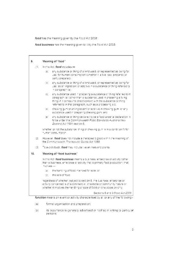
FOR ELECTED MEMBERS’
BRIEFING SESSION
Draft Only
to be held at
the Civic Centre,
Dundebar Rd, Wanneroo
on 06 October, 2015 commencing at 6.00pm
PROCEDURE FOR FULL COUNCIL BRIEFING
PRINCIPLES
A Council Briefing occurs a week prior to the Ordinary Council Meeting and provides an opportunity for Elected Members to ask questions and clarify issues relevant to the specific agenda items before council. The briefing is not a decision-making forum and the Council has no power to make decisions. The briefing session will not be used, except in an emergency, as a venue or forum through which to invoke the requirements of the Local Government Act 1995 and call a special meeting of Council.
In order to ensure full transparency the meetings will be open to the public to observe the process. Where matters are of a confidential nature, they will be deferred to the conclusion of the briefing and at that point, the briefing session closed to the public. The reports provided are the Officers’ professional opinions. While it is acknowledged that Elected Members may raise issues that have not been considered in the formulation of the report and recommendation, it is a basic principle that as part of the briefing sessions Elected Members cannot direct Officers to change their reports or recommendations.
PROCESS
The briefing session will commence at 6.00 pm and will be chaired by the Mayor or in his/her absence the Deputy Mayor. In the absence of both, Councillors will elect a chairperson from amongst those present. In general, Standing Orders will apply, EXCEPT THAT Elected Members may speak more than once on any item, there is no moving or seconding items, Officers will address the Elected Members and the order of business will be as follows:-
Members of the public present may observe the process and there is an opportunity at the conclusion of the briefing for a public question time where members of the public may ask questions (no statements) relating only to the business on the agenda. The agenda will take the form of:
Ø Attendance and Apologies
Ø Declarations of Interest
Ø Reports for discussion
Ø Tabled Items
Ø Public Question Time
Ø Closure
Where an interest is involved in relation to an item, the same procedure which applies to Ordinary Council meetings will apply. It is a breach of the City’s Code of Conduct for an interest to not be declared. The briefing session will consider items on the agenda only and proceed to deal with each item as they appear. The process will be for the Mayor to call each item number in sequence and ask for questions. Where there are no questions regarding the item, the briefing will proceed to the next item.
AGENDA CONTENTS
While every endeavour is made to ensure that all items to be presented to Council at the Ordinary Council Meeting are included in the briefing papers, it should be noted that there will be occasions when, due to necessity, items will not be ready in time for the briefing session and will go straight to the Full Council agenda as a matter for decision. Further, there will be occasions when items are TABLED at the briefing rather than the full report being provided in advance. In these instances, staff will endeavour to include the item on the agenda as a late item, noting that a report will be tabled at the agenda briefing session.
AGENDA DISTRIBUTION
The Council Briefing agenda will be distributed to Elected Members on the FRIDAY prior to the Council Briefing session. Copies will be made available to the libraries and the Internet for interested members of the public. Spare briefing papers will be available at the briefing session for interested members of the public.
DEPUTATIONS
Deputations will generally not be heard prior to the Council Briefing session and are reserved for prior to the Ordinary Council meeting.
RECORD OF BRIEFING
The formal record of the Council Briefing session will be limited to notes regarding any agreed action to be taken by staff or Elected Members. No recommendations will be included and the notes will be retained for reference and are not distributed to Elected Members or the public.
LOCATION
The Council Briefing session will take place in the Council Chamber in the Civic Centre.

Briefing Papers for Tuesday 6 October, 2015
CONTENTS
Item 2_____ Apologies and Leave of Absence
Town Planning Schemes & Structure Plans
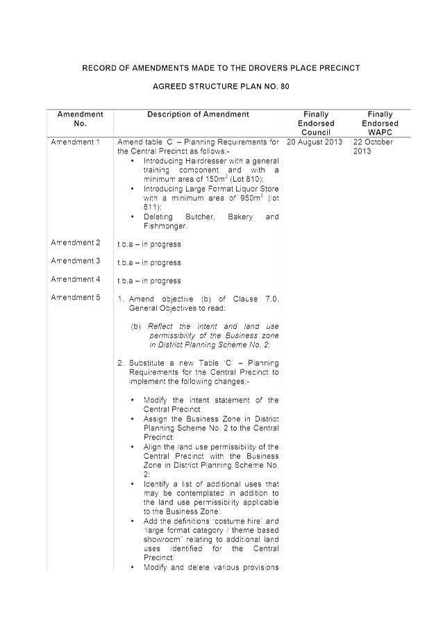
3.2 Reconsideration of Amendment No. 4 to Drovers Place Precinct Agreed Structure Plan No. 80
3.3 Proposed Amendment No. 102 to District Planning Scheme No. 2 - East Wanneroo Cell 9
3.4 Adoption of Amendment No. 2 to the Banksia Grove District Centre Agreed Structure Plan No. 65
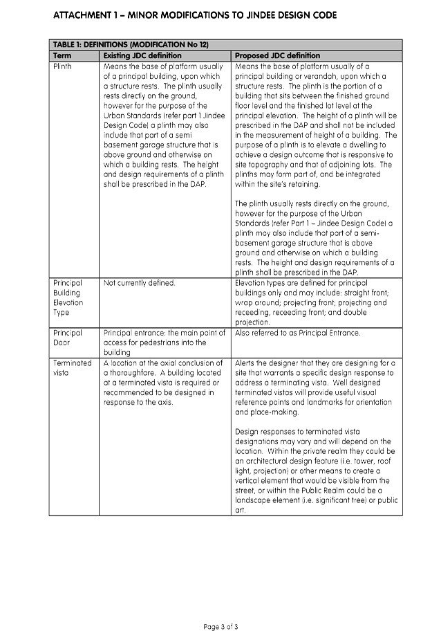
3.5 Adoption of Amendment No. 1 to the Jindee Design Code (Jindee Agreed Structure Plan No. 84)
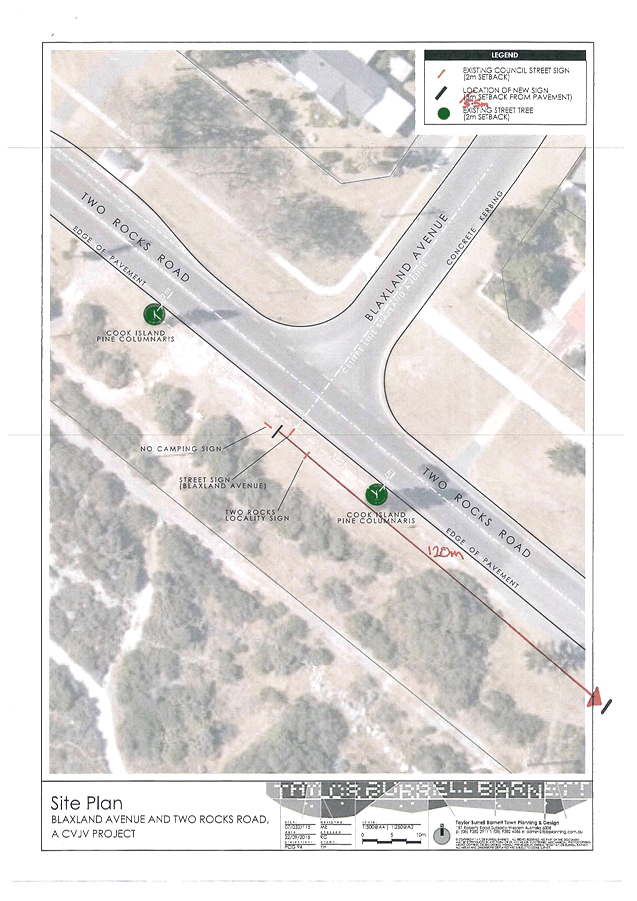
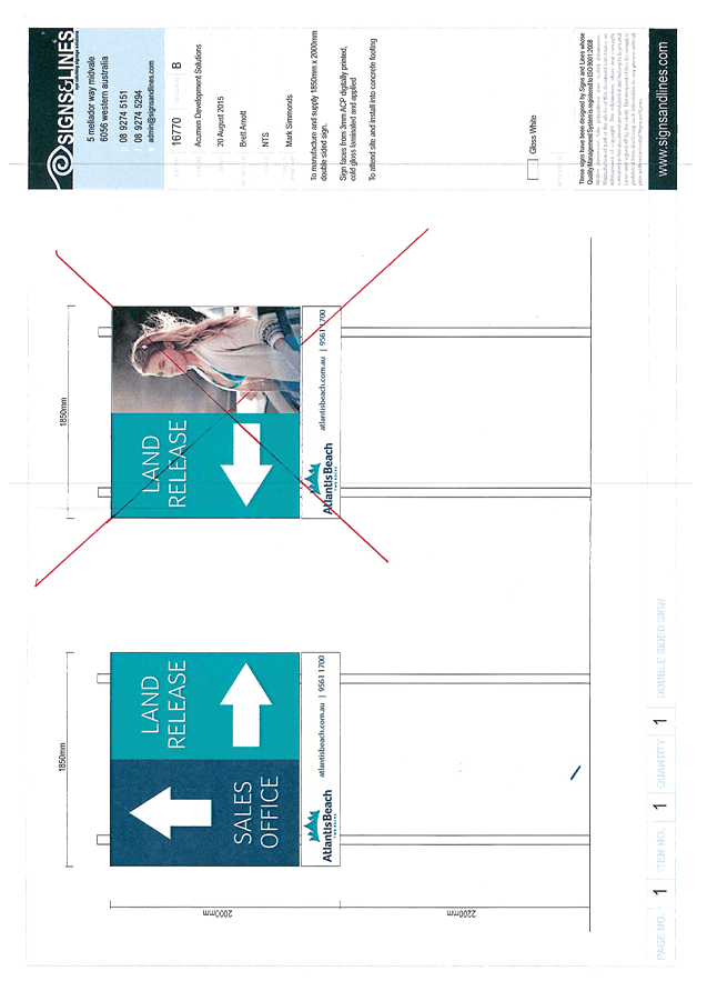
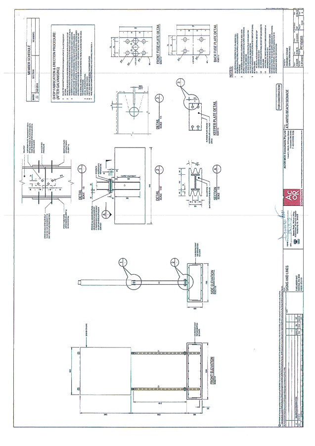
3.10 Road Reserve Sign (Blaxland Ave/Two Rocks Road Intersection) - DA2015/1435
3.12 Yanchep Surf Life Saving Club and Public Amenities Facility Status Report
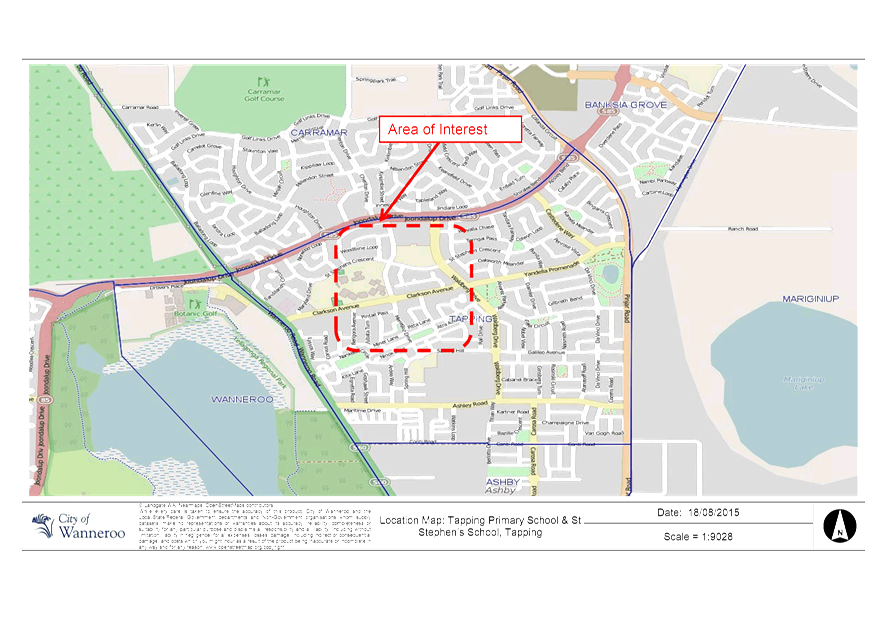
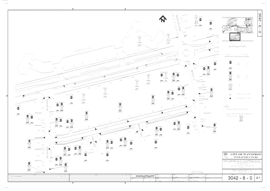
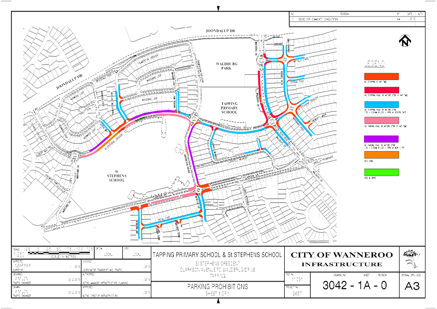
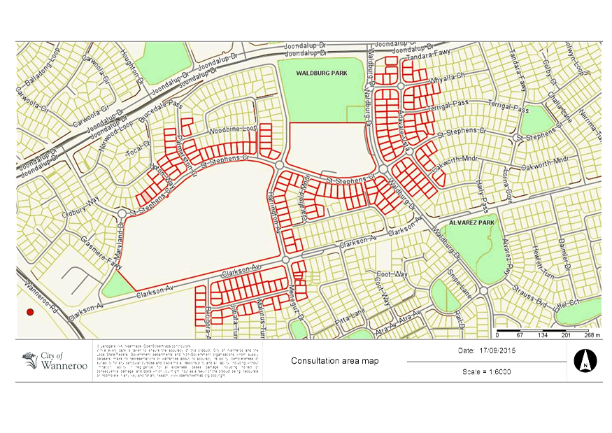
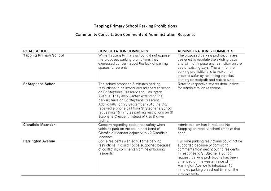
3.13 PT02-11/14 Tapping Primary School - Parking Prohibitions
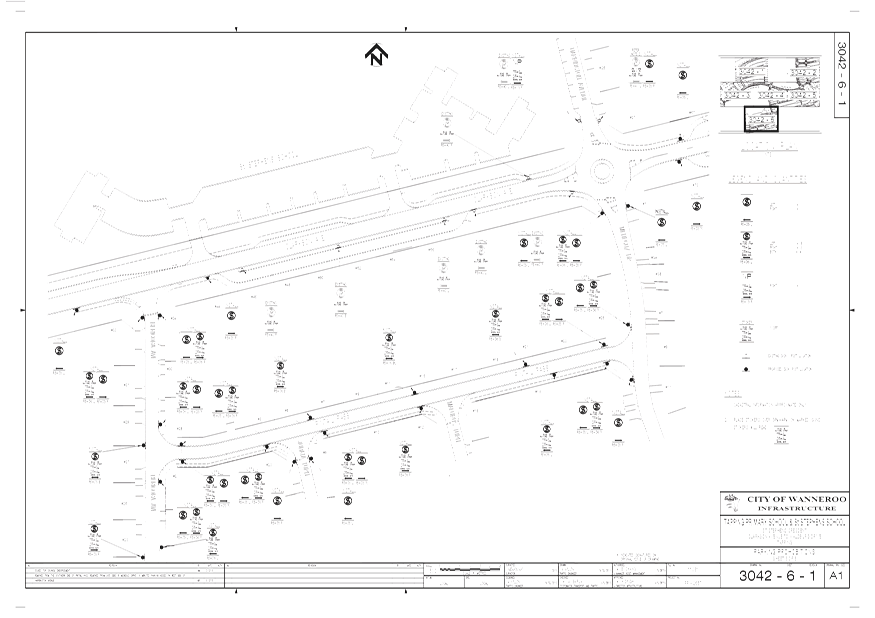
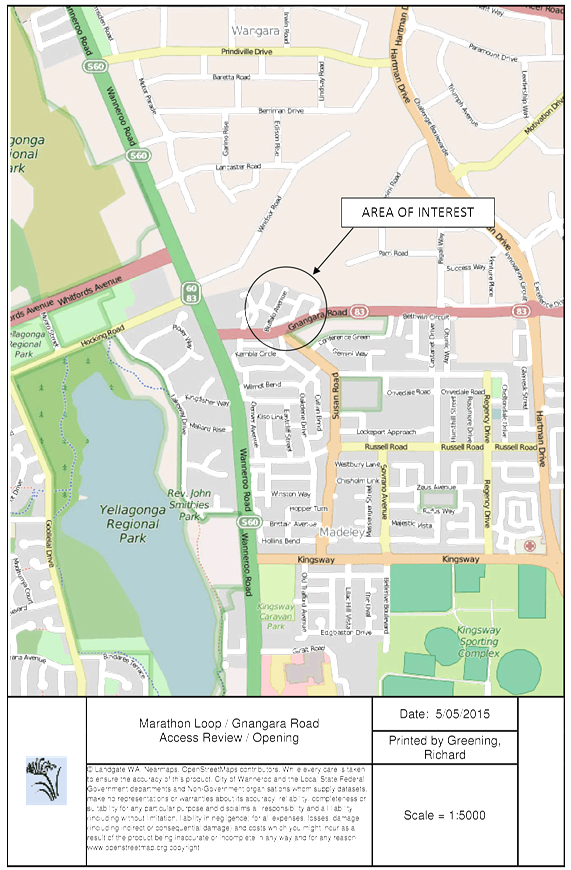
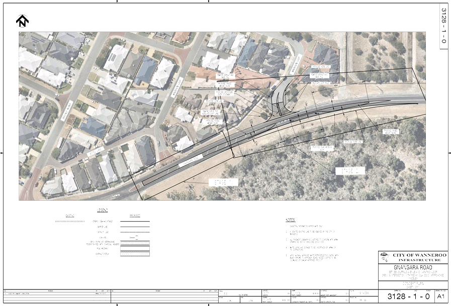
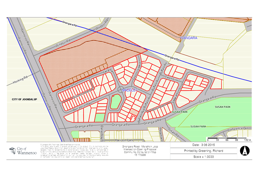
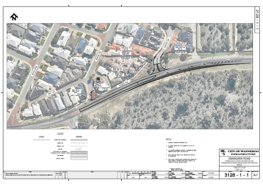
3.14 Marathon Loop/Gnangara Road - Review of Vehicular Access - Community Consultation Outcomes
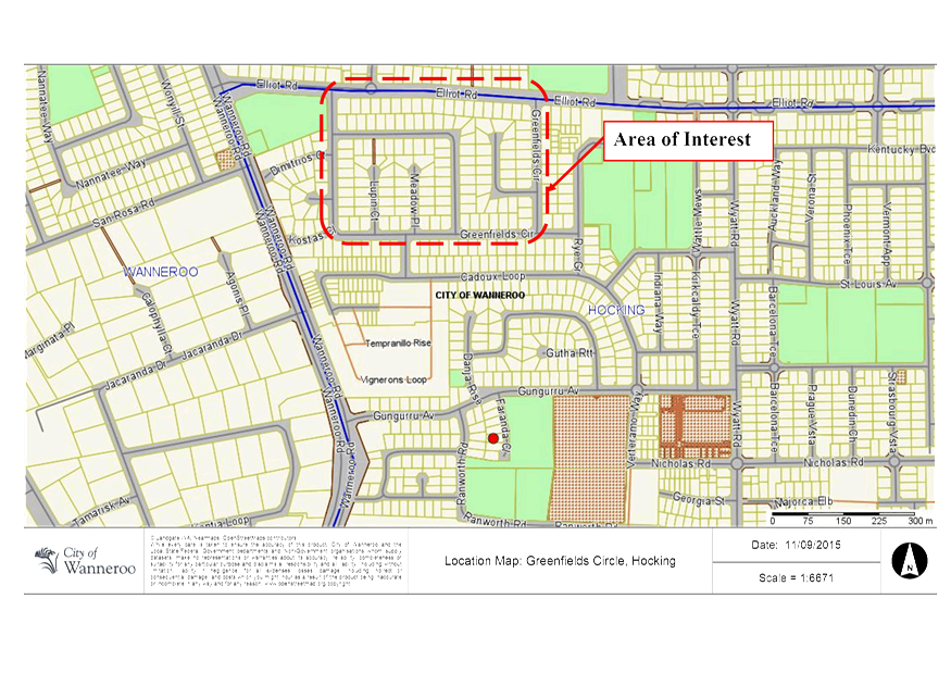
3.15 PT03-06/15 Greenfields Circle, Hocking - Request for Speed Humps
3.16 Shark Barrier Feasibility Study
3.17 PT03-03/15 Gumblossom Sports Hall Update
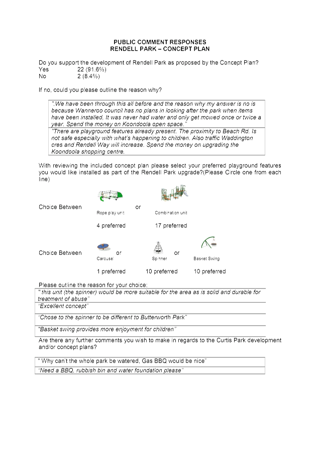
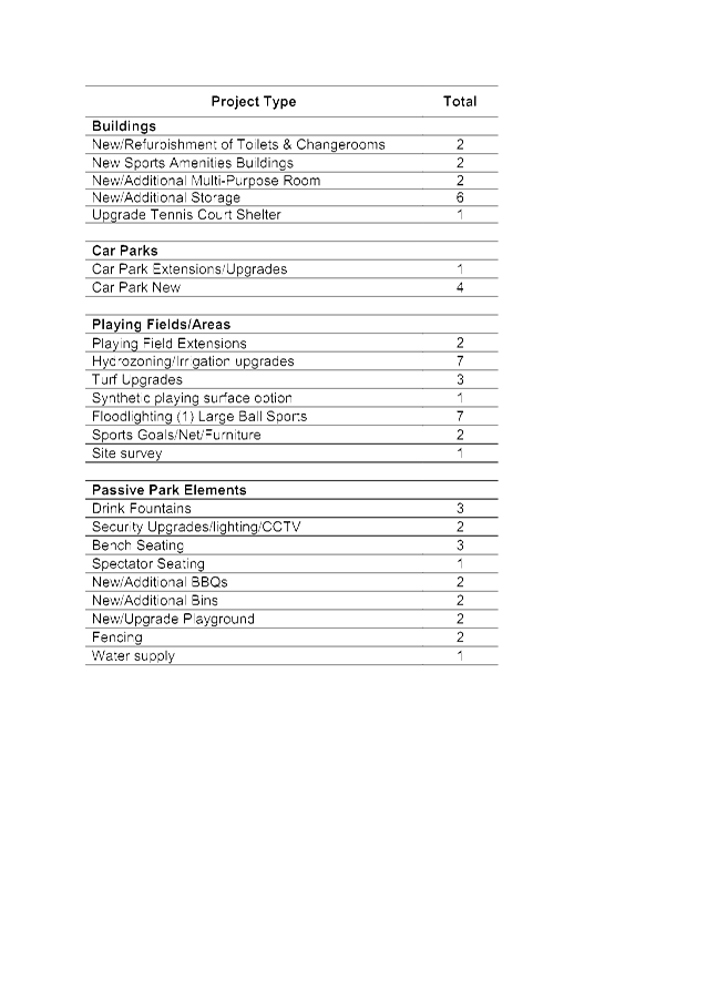
3.18 Passive Park Upgrade - Rendell Park Concept Plan
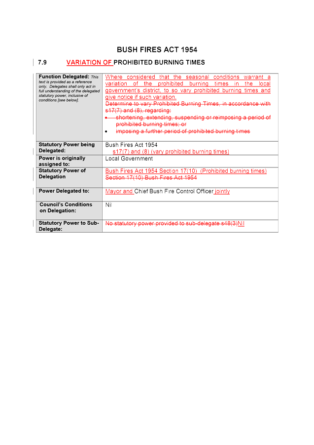
3.20 Prohibited Burning Times - Amendment to Delegated Authority 7.9
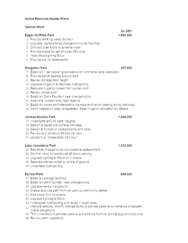
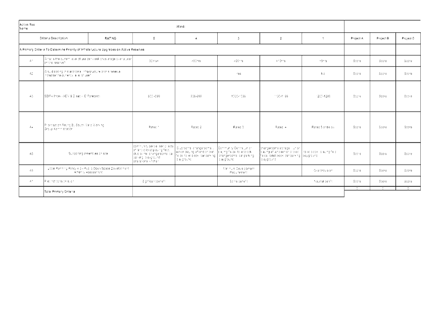
3.21 Central Ward and Coastal Ward Active Reserve Master Planning Process Outcomes
Corporate Strategy & Performance
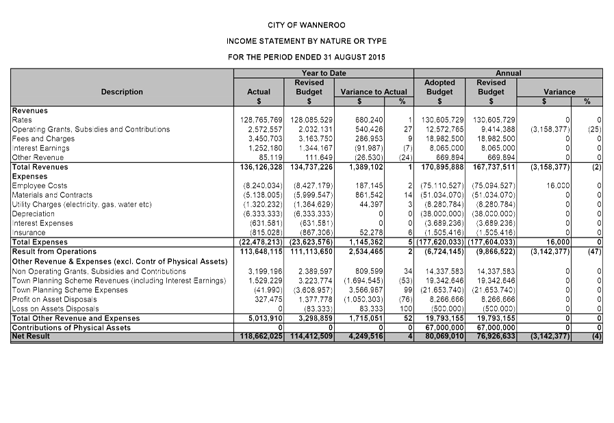
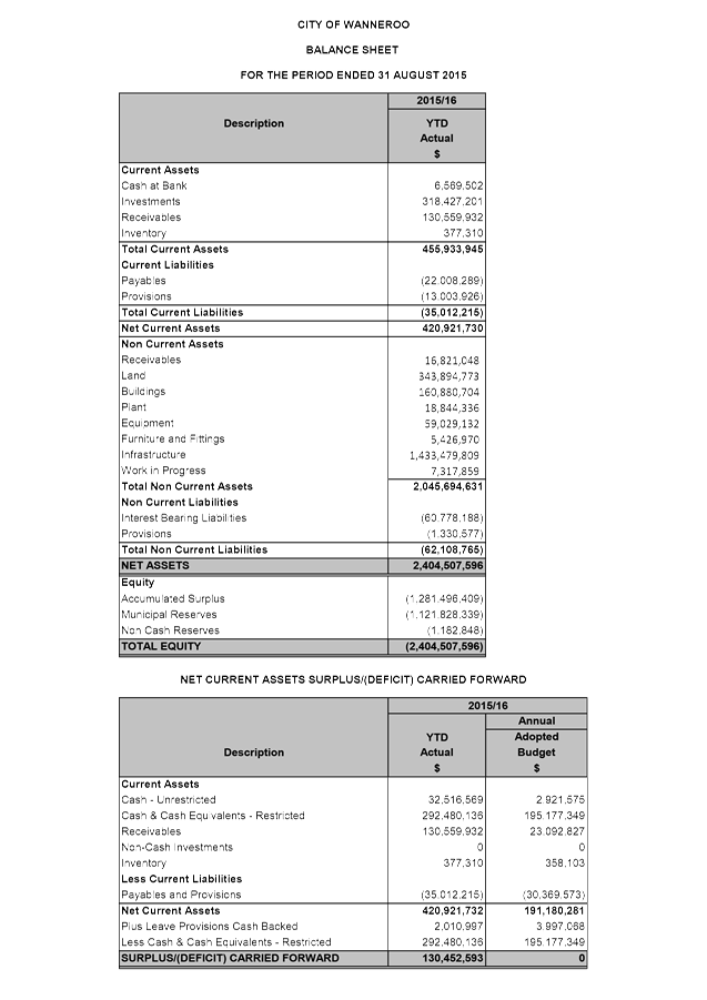
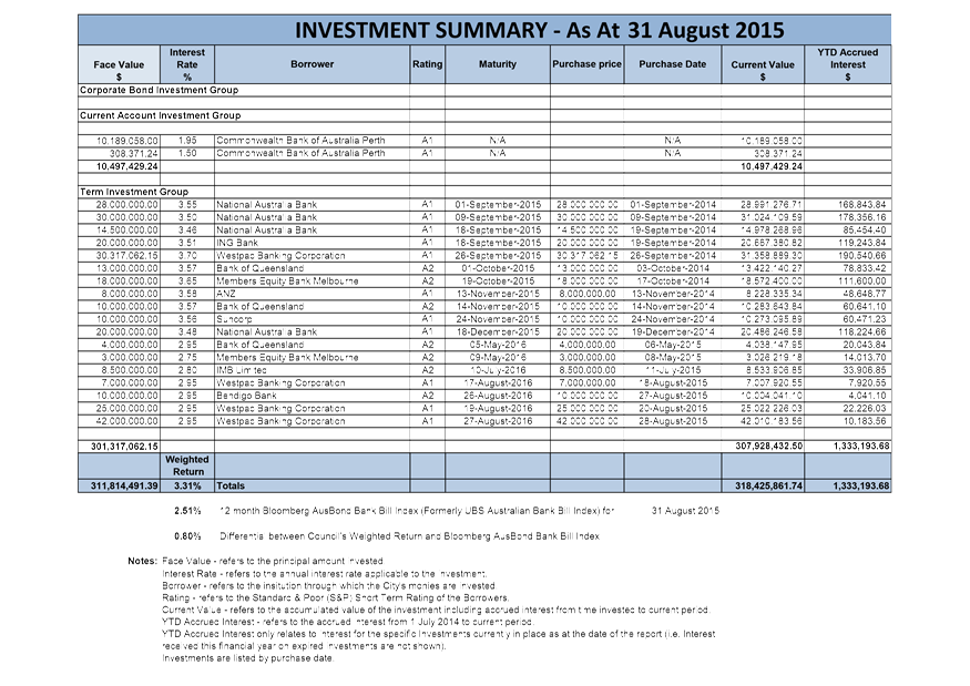
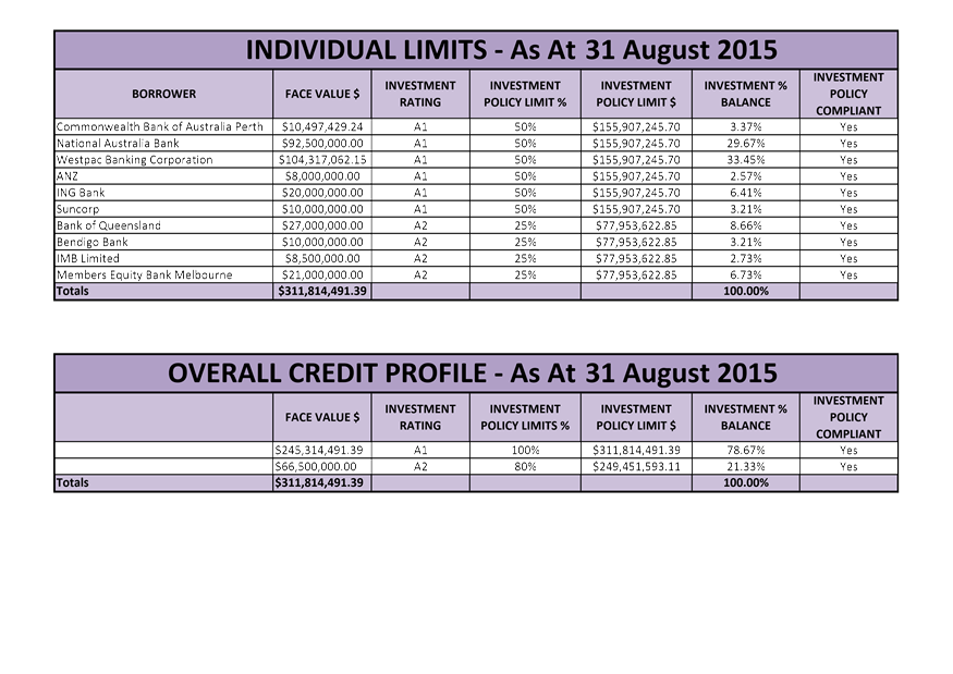
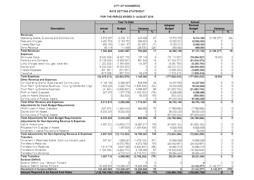
3.22 Financial Activity Statement for the Period Ended 31 August 2015
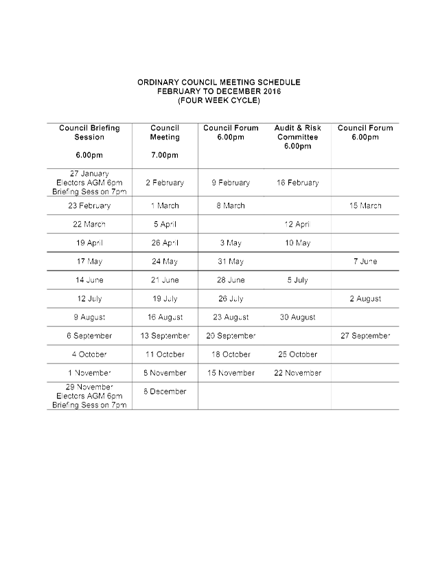
3.23 Proposed Council Meeting Dates for 2016
3.24 Donations to be Considered by Council - October 2015
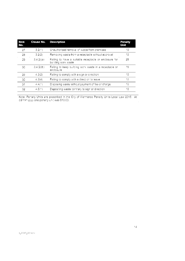
3.25 City of Wanneroo Penalty Units Local Law
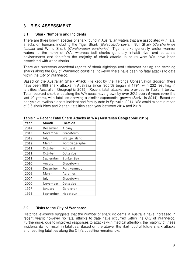
3.26 City of Wanneroo Waste Local Law
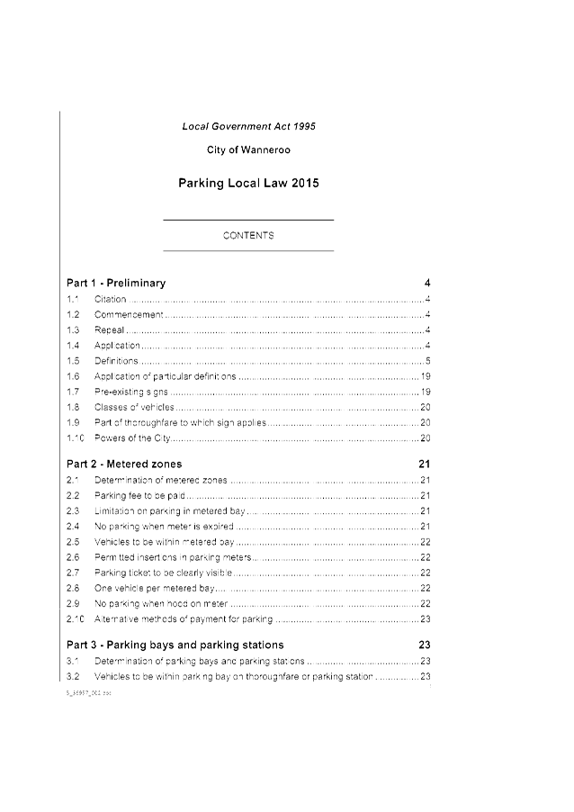
3.27 City of Wanneroo Parking Local Law 2015
3.28 City of Wanneroo Public Places and Local Government Property Local Law 2015
Information Communication Technology
3.29 Proposal for Renaming a Section of Mossfiel Retreat, Landsdale
3.30 Tender 01527 for the Provision of Internal Audit Services for a Period of 33 Months
Item 5_____ Late Reports (to be circulated under separate cover)
5.1 Warrant of Payments for the Period to 30 September 2015
Item 6_____ Public Question Time
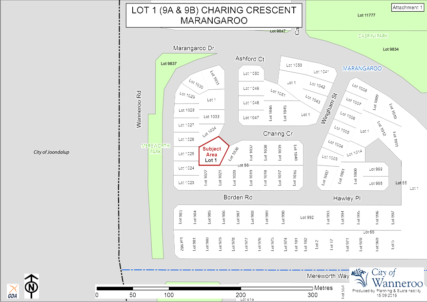
7.1 Acquisition of Lot 29 (6) McNamara Place, Marangaroo
Item 8_____ Date of Next Meeting
Agenda
Good evening Councillors, staff, ladies and gentlemen, we wish to acknowledge the traditional custodians of the land we are meeting on, the Whadjuk people. We would like to pay respect to the Elders of the Nyoongar nation, past and present, who have walked and cared for the land and we acknowledge and respect their continuing culture and the contributions made to the life of this city and this region and I invite you to bow your head in prayer:
Lord, We ask for your blessing upon our City, our community and our Council. Guide us in our decision making to act fairly, without fear or favour and with compassion, integrity and honesty. May we show true leadership, be inclusive of all, and guide the City of Wanneroo to a prosperous future that all may share. We ask this in your name. Amen
Item 2 Apologies and Leave of Absence
RECOMMENDATION
That Council GRANT a Leave of Absence to:-
Cr Aitken for the period 15 – 31 October 2015 inclusive.
Declarations of Interest by Elected Members, including the nature and extent of the interest. Declaration of Interest forms to be completed and handed to the Chief Executive Officer.
Town Planning Schemes & Structure Plans
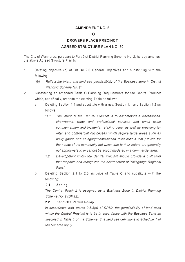
3.1 Amendment No. 5 to Drovers Place Precinct Agreed Structure Plan No. 80 - Consideration of Modifications
File Ref: 2957-05 – 15/223420
Responsible Officer: Director Planning and Sustainability
Disclosure of Interest: Nil
Attachments: 7
Issue
To reconsider Amendment No. 5 to Drovers Place Precinct Agreed Structure Plan No. 80 (ASP 80), incorporating the modifications required by the Western Australian Planning Commission (WAPC).
|
Applicant |
TPG Town Planning, Urban Design and Heritage |
|
Location |
Lot 1 (1369) Wanneroo Road, Wanneroo Lot 132 (1351) Wanneroo Road, Wanneroo Lot 810 (1397) Wanneroo Road, Wanneroo Lot 811 (1387) Wanneroo Road, Wanneroo |
|
Owner – Lot 1 and Lot 132 |
Lakewide Pty Ltd |
|
Owner – Lot 810 and Lot 811 |
Goldrange Pty Ltd & Greenpark Asset Pty Ltd |
|
Site Area |
Lot 1 – 3.2871 hectares Lot 132 – 3.4087 hectares Lot 810 – 2.8009 hectares Lot 811 – 2.9488 hectares |
|
MRS Zoning |
Urban |
|
DPS 2 Zoning |
Urban Development |
|
ASP 80 Zoning |
Special Use |
Background
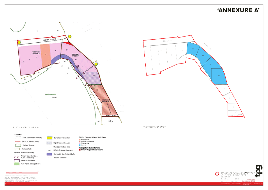
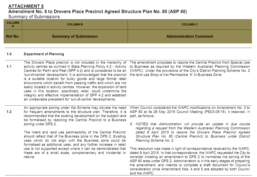
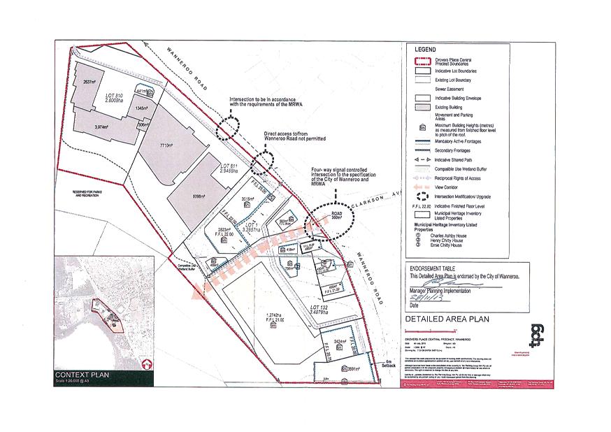
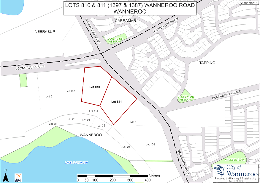
On 10 November 2014, TPG Town Planning, Urban Design and Heritage, on behalf of the landowner of Lot 1 and Lot 132, lodged Amendment No. 5 to ASP 80 for the City’s consideration. The amendment proposals also have an effect on the adjoining Lot 810 (1397) and Lot 811 (1387) Wanneroo Road, Wanneroo, as discussed in the Detail section of the Report. A plan showing the location of Lots 1, 132, 810 and 811 is provided as Attachment 1. All four lots are situated within the Central Precinct of ASP 80, which ASP 80 zones as Special Use.
On 24 November 2014, the Manager, Planning Implementation forwarded a memorandum to all Elected Members providing them with the opportunity to request referral of the proposal to Council for consent to advertise. No such requests were received and, as such, advertising of Amendment No. 5 to ASP 80 was carried out between 16 December 2014 and 4 February 2015 in accordance with Clause 9.5 of District Planning Scheme No. 2 (DPS 2).
Council at its meeting of 31 March 2015 (PS11-03/15) resolved to adopt Amendment No. 5 subject to modifications and to forward the modified amendment document to the WAPC for its adoption and certification. On 29 May 2015, the WAPC advised the City that it adopted Amendment No. 5 subject to modifications. The applicant has submitted to the City the modified amendment document as required by the WAPC including additional development provisions as discussed later in the Report.
Detail
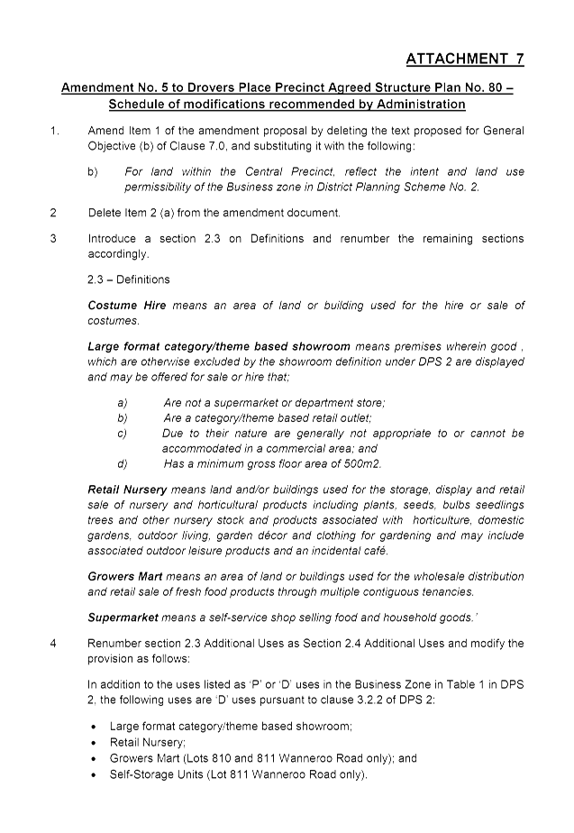
The WAPC considered the Amendment No. 5 proposal and advised Administration in correspondence dated 29 May 2015 that it resolved to adopt the amendment subject to modifications outlined in Attachment 2. The modifications are summarised as follows:
1. To amend the general objectives included in Clause 7.0 of the structure plan to better respond to the ongoing planning of the ASP 80 Central Precinct;
2. To rezone the land within the Central Precinct from ‘Special Use’ to ‘Business’. This will require modifications to the ASP 80 text as well as to the map;
3. Land use permissibility in the Central Precinct being consistent with that of the Business Zone under DPS 2. The WAPC modifications also require the inclusion of some additional uses as Discretionary Uses in the Central Precinct;
4. The Statement of Intent for the Central Precinct being amended to align with the Intent for the Business Zone, outlined in Clause 3.6.1 of DPS 2; and
5. The landowner of Lot 1 and Lot 132 to pursue cost sharing arrangements with other nearby landowners and any other authority or person subject to a separate agreement on the design and construction of a four-way signalised intersection at the intersection of Wanneroo Road and Clarkson Avenue.
As the applicant was required to modify the amendment in light of the WAPC decision, the applicant has taken the opportunity to propose modifications to the development provisions applicable for the Central Precinct as outlined in Section 3 of Table C – Planning Requirements for the Central Precinct (herein after referred to as Table C) of ASP 80. The revised amendment document as submitted by the applicant is included as Attachment 3.
The applicant has prepared a revised amendment document, incorporating the changes required by the WAPC as well as the changes to the development provisions prescribed in Section 3 of Table C. The revised amendment document has been included as Attachment 4.
Consultation
Prior to Council’s initial adoption of Amendment No. 5 at its 31 March 2015 meeting, the amendment was advertised for public comment by means of an on-site sign, an advertisement in the Wanneroo Times newspaper, display on the City’s website and letters to adjoining landowners. At that time, Administration received four submissions, which were summarised and responded to by Administration in the report presented to the 31 March 2015 Council Meeting (PS11-03/15).
Should a revised structure planning proposal be prepared following modifications required by the WAPC, further public notification of a Structure Plan may only be waived where Council is satisfied of the following, in accordance with Clause 3.8 of the City’s Local Planning Policy 4.2: Structure Planning (LPP 4.2):
a) The modification(s) does not significantly or materially depart from the version of the Structure Plan that was advertised for public comment;
b) The modification is in response to a submission(s) received during the advertising period; and
c) Re-advertising of the modified structure plan would be unlikely to cause the modifications(s) to be reconsidered.
Administration considered that further consultation of the amendment was required for the following reasons:
· The modifications sought by the WAPC and the applicant, significantly and materially depart from the version of the amendment that was previously advertised, particularly as:
o Land use permissibility in the Central Precinct resulting from the WAPC modifications would vary significantly from the land use permissibility adopted by Council in its previous considerations of Amendment No. 5; and
o The amendment now proposes changes to the development provisions contained in Table C; and
· The modifications sought by the WAPC were not as a result of the submissions received when Amendment No. 5 was initially advertised between 16 December 2014 and 4 February 2015 for public comment.
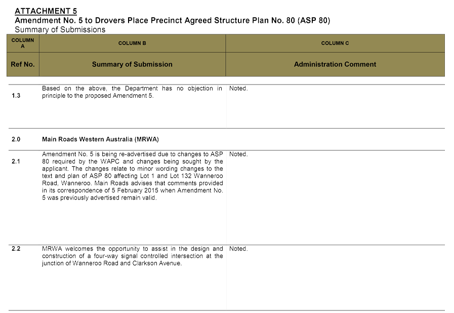
Amendment No. 5 was re-advertised for public comment by means of an on-site sign, an advertisement in the Wanneroo Times newspaper, display on the City’s website and letters written to adjoining landowners for a period of 28 days from 21 July to 18 August 2015. The City received eight submissions.
Three of the submissions were from the same submitter representing three different landowners. A summary of submissions received and Administration's responses to each is provided in Attachment 5.
Comment
Amendment No. 5 proposes changes to the ASP 80 text and map, as outlined in the ‘Detail’ section above. The comments below expand and further discuss the key matters associated with the amendment proposal:
Changes to Zoning, Land Use Definitions and Permissibility
As a result of modifications required by the WAPC, Amendment No. 5 now proposes to rezone the ASP 80 Central Precinct to Business. Administration supports the rezoning of the Central Precinct for the following reasons:
· The development on Lot 810 and Lot 811 is identified as an ‘out-of-centre’ development under Local Planning Policy 3.2: Activity Centres (LPP 3.2). Although currently vacant, the development envisioned by the landowners of Lot 1 and Lot 132 could potentially be recognised as an ‘out-of-centre development’ once completed. State Planning Policy 4.2: Activity Centres for Perth and Peel (SPP 4.2) stipulates that ‘out-of-centre’ development should be restricted to ‘Mixed Business’ or equivalent zones. In the context of the zonings in DPS 2, the Business zone is considered by Administration as a satisfactory equivalent in this instance; and
· The application of Business Zone for the Central Precinct recognises that the ASP 80 Central Precinct is not a defined activity centre under SPP 4.2, but rather an ‘out-of-centre development’.
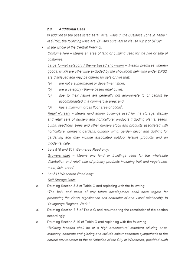
The permissibility of land uses in the Central Precinct will be those applicable to Business Zone as per the provisions of DPS 2. In addition, as required by the WAPC, land uses typically not permitted in the ‘Business Zone’ will be discretionary (’D’) uses in the ASP 80 Central Precinct – with those uses being ‘Large Format Category/Theme Based Showroom’, ‘Retail Nursery’, ‘Growers Mart’ and ‘Self-storage Units’. The suitability of these additional land uses being discretionary in the ASP 80 Central Precinct are discussed later in the Report.
Revision to the General Objectives
In the previous consideration of Amendment No. 5, Council resolved to adopt General Objectives (b) and (e) – contained in Clause 7.0 of the ASP 80 text – to read as follows:
(b) Provide for land uses that do not significantly compromise the viability of nearby Activity Centres.
(e) Provide a zoning and use control framework that maintains the character of developed precincts.
In considering Amendment No. 5, the WAPC required that Objective (b) be modified as follows:
(b) Reflect the intent and land use permissibility of the Business zone in District Planning Scheme No. 2.
In ongoing discussions between the City and the Department of Planning in relation to General Objective (b), the City’s officers identified that this modification would apply to the entire ASP 80 area, not just to the land parcels that would be zoned Business in ASP 80. In response, the Department has agreed that the modification to the objective could be considered to make specific reference to land in the Central Precinct as follows:
(b) For land within the Central Precinct, reflect the intent and land use permissibility of the Business zone in District Planning Scheme No. 2.
Administration supports the modification to General Objective (b) as it is aligned to the proposed rezoning of the ASP 80 Central Precinct to ‘Business’.
The WAPC has required the deletion of General Objective (e), which the applicant was in agreement with this modification. In this regard, Administration notes that the aspect ‘the zoning and use control framework’ of this objective is covered in the above modified General Objective (b).
Additional Uses
The modifications to the amendment proposal prescribe the following as discretionary (‘D’) land uses:
· Costume Hire;
· Large Format Category/Theme Based Showroom;
· Retail Nursery;
· Growers Mart; and
· Self-Storage Units.
With exception to the ‘Costume Hire’ land use, the abovelisted uses are typically not permitted in the ‘Business’ Zone. The land use ‘Costume Hire’ is a Permissible ‘P’ use in the Business zone, however was prescribed as a discretionary (‘D’) land use, to reflect the decision of the WAPC.
The revised amendment proposal also includes a definition for Costume Hire, Large Format Category/Theme Based Showroom, Retail Nursery and Growers Mart. Further discussion on the acceptability of the proposed permissibility for the subject land uses is outlined in more detail later in this section.
Large Format Category/Theme Based Showroom Use Class
During the WAPC’s consideration of Amendment No. 5, the applicant highlighted to the City and the Department of Planning officers that the ‘Showroom’ land use would preclude the establishment of some large-format retailers in the amendment area. The preclusion relates to the definition for ‘Showroom’, outlined in Schedule 1 of DPS 2 and is as follows:
Showroom : means premises wherein goods are displayed and may be offered for sale or hire excluding the sale of foodstuffs, liquor or beverages, items of clothing or apparel (except as hereinafter stipulated in this definition) or personal adornment, magazines, books, newspapers or paper products, and medicinal or pharmaceutical products unless assembled or manufactured on the premises. The term includes the sale of secondhand clothing or apparel by welfare and charitable agencies with the approval of Council.
The applicant has argued that the ‘Showroom’ definition excludes the sale of certain products which are found in many ‘Showroom’ premises, and would prevent the establishment of premises for the sale of:
· Sporting, cycling, leisure, fitness goods, clothing and accessories;
· Office equipment and supplies;
· Baby and children’s goods and clothing, children’s play equipment and accessories;
· Camping, outdoor and recreation goods and clothing; and/or
· Animal supplies, including pet goods, and equestrian goods and clothing.
To respond to this issue, the applicant – through the WAPC assessment and subsequent decision on the amendment – sought the formulation of the ‘Large Format Category/Themed Based Showroom’. This use class proposes to have the following definition:
Large Format Category/Theme Based Showroom – means premises wherein goods, which are otherwise excluded by the showroom definition under DPS 2, are displayed and may be offered for sale or hire that:
· Are not a supermarket or department store;
· Are a category/theme based outlet;
· Due to their nature are generally not appropriate to or cannot be accommodated in a commercial area; and
· Has a minimum gross floor area of 500m2.
The above definition was adopted by the WAPC in its decision of Amendment No. 5. In its considerations of Amendment No. 5, the WAPC acknowledged that ASP 80 Central Precinct is a suitable location for bulky goods and large format retail showrooms. Administration also has no objection to this land use being introduced for the following reasons:
· The introduction of this land use is consistent with the Statement of Intent relevant for the ASP 80 Central Precinct. The Statement of Intent stipulates that the Central Precinct is to accommodate for (among other business and development types) retail and commercial businesses which require large areas such as bulky goods and category/theme-based retail outlets; and
· This land use is consistent with the land uses intended for an ‘out-of-centre’ development as stipulated in the LPP 3.2 and SPP 4.2.
Retail Nursery
Retail Nursery is currently a Discretionary Use in the Central Precinct. Therefore to retain it as such in the Business Zone is acceptable.
Growers Mart
This land use is proposed to be allowed only on Lots 810 and 811 Wanneroo Road.
The WAPC in its proposed Statutory Section of Amendment No. 5 required the land use Growers Mart to be defined as follows:
‘means any land or buildings used for the wholesale distribution and retail sale of primary products including fruit and vegetable, meat, fish bread.’
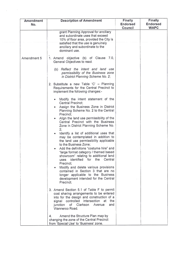
In this regard it is noted that Council in its previous deliberations on Amendment No. 4 made at the 14 October 2014 Council meeting adopted the following definition for the Growers Mart land use:
Growers Mart – means an area of land or buildings used for the wholesale distribution and retail sale of fresh food products through multiple contiguous tenancies.
Modifications to the Growers Mart definition are discussed further in the Amendment No. 4 Report, included in this meeting Agenda.
Self-Storage Units
ASP 80 currently permits this land use on Lot 811 Wanneroo Road only.
In previous deliberations of Amendment No. 4 and No. 5, Council supported the land use permissibility for ‘Self-Storage Units’ (referred to as the ‘Storage Yard’ land use in previous Reports) as discretionary (‘D’) in the ASP 80 Central Precinct. Administration continues to support land use permissibility as currently proposed.
Land Use Definitions – ‘Supermarket’ and ‘Costume Hire’
In the definition for the land use ‘Large Format Category/Theme Based Showroom’ reference is made to the land use Supermarket. However, DPS 2 does not provide for a definition for ‘Supermarket’ (although this land use is listed in the Zoning Table of DPS 2). To more effectively interpret the definition for the Large Format Category/Theme Based Showroom’ can be applied, it is therefore recommended (in light of comments received through submissions) that ‘Supermarket’ also be defined in ASP 80 as follows:
‘Supermarket : means a self-service shop selling food and household goods.’
The ‘Costume Hire’ is also a land use referred to in Table 1 of DPS 2, but does not have a prescribed. Therefore, Administration supports the following definition being included in ASP 80 for the ‘Costume Hire’ land use:
‘Costume Hire : means an area of land or building used for the hire and sale of costumes’
Administration recommends that a subsection of Table C be included to accommodate the abovementioned definitions for the ‘Supermarket’ and ‘Costume Hire’ land uses.
Changes to the Statement of Intent
Since Council’s previous adoption of Amendment No. 5 resolved at the 31 March 2015 Council meeting, changes to the Statement of Intent were adopted by the City and WAPC through Amendment No. 3 to ASP 80. The changes to the Statement of Intent sought through Amendment No. 3 are now formally included within the ASP 80 text. The Statement of Intent proposed in Amendment No. 5 is the same as that now included in ASP 80, and therefore the inclusion of this item in the Amendment No. 5 proposal is unnecessary.
Administration is therefore recommending a modification that would remove the proposed change to the Statement of Intent from the Amendment No. 5 proposal.
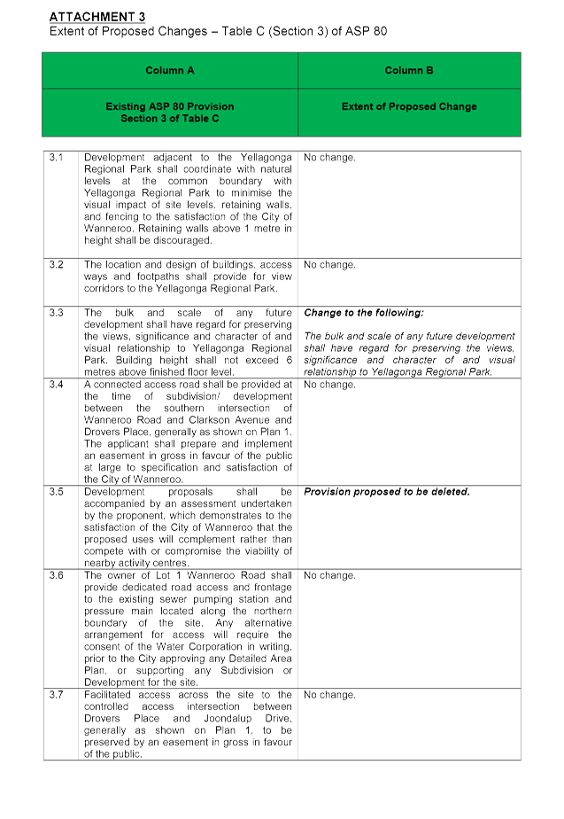
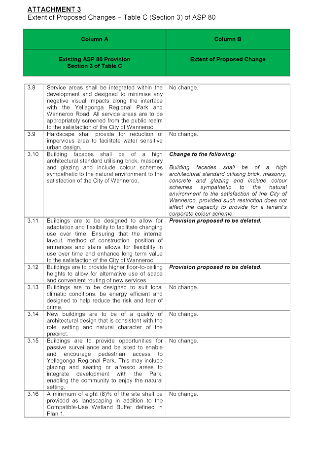
Changes to the Development Provisions
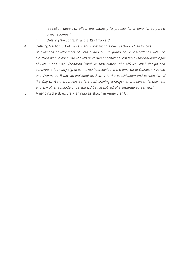
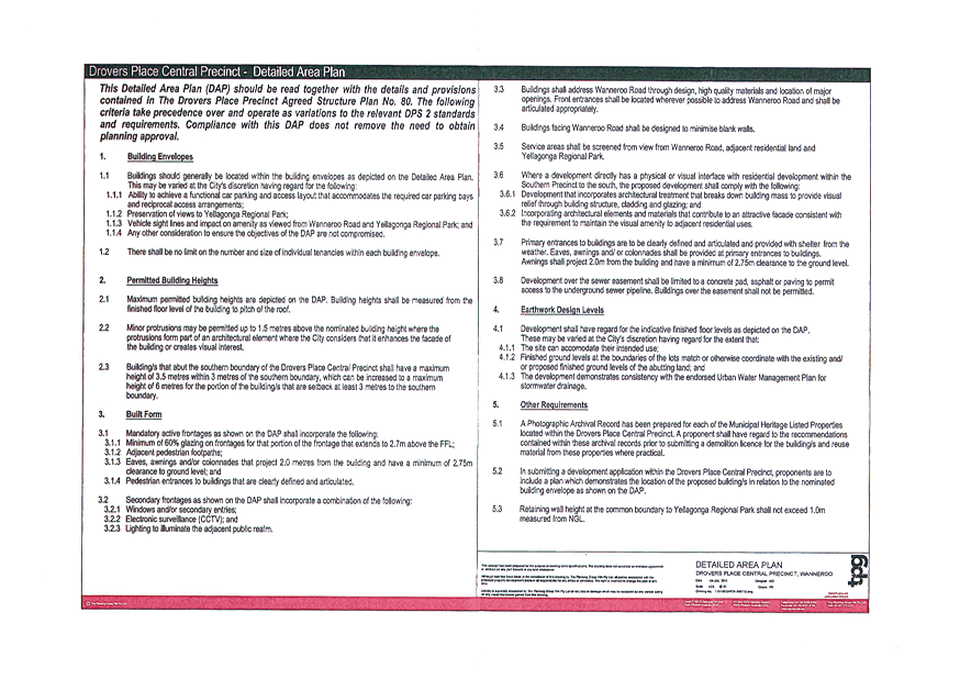
The extent of changes to the development provisions contained in Table C of ASP 80 is outlined in Attachment 3. The modifications are to delete Provisions 3.5, 3.11 and 3.12 and to delete Provisions 3.3 and 3.10 and to replace them with modified provisions. Comments on the proposed changes to the development provisions are provided below:
Deleted Provisions
· The deletion of Provision 3.5 would remove the requirement for a proponent to include, with a development proposal, a demonstration that proposed uses would complement, rather than compete with the viability of activity centres. The applicant has argued that it should not be necessary to justify land uses that are consistent with the range of land uses permissible under the Business zone, as this zone has specifically been established to promote business/commercial uses that will not compete with the retail component of activity centres. Administration supports the applicant’s argument and the deletion of the provision.
· The deletion of Provision 3.11 would remove the requirement for buildings to be designed to allow for adaption and flexibility of use. The applicant argues that this provision implies a temporary land use arrangement and/or a significant change in land use over time. As the applicant proposes to develop the site for long term intentions, this provision is not considered necessary and therefore Administration agrees that it be deleted.
· It is proposed to delete Provision 3.12 which requires higher floor-to-ceiling heights to allow for alternative use of space and convenient routing of new services. Considering the long term intention for the site as noted above in regard to Provision 3.11 it is recommended to delete this provision.
Modified Provisions
· Changes to Section 3.3 relates to building heights and the future developments preserving the views, significance and character of Yellagonga Regional Park. The applicant has proposed to delete a part of the provision on building heights (see Attachment 3). Currently development in the Central Precinct is subject to the provisions of a Detailed Area Plan (DAP), which can be referred to in Attachment 6. The DAP prescribes maximum building heights within the ASP 80 Central Precinct, and therefore it is considered that height restriction provisions are not required to be included in the ASP 80 text.
· Section 3.10 requires the colour scheme of a development to be sympathetic to the natural environment to the satisfaction of the City. However, the applicant is proposing to change the provision to allow for a tenant’s corporate colour scheme to be provided, irrespective of whether it is sympathetic to the natural environment or not.
This Statement of Intent item 1.2 states that the built form is to respect and recognise the environment of Yellagonga Regional Park. Administration does not support corporate colours as they may not be sympathetic to the natural environment.
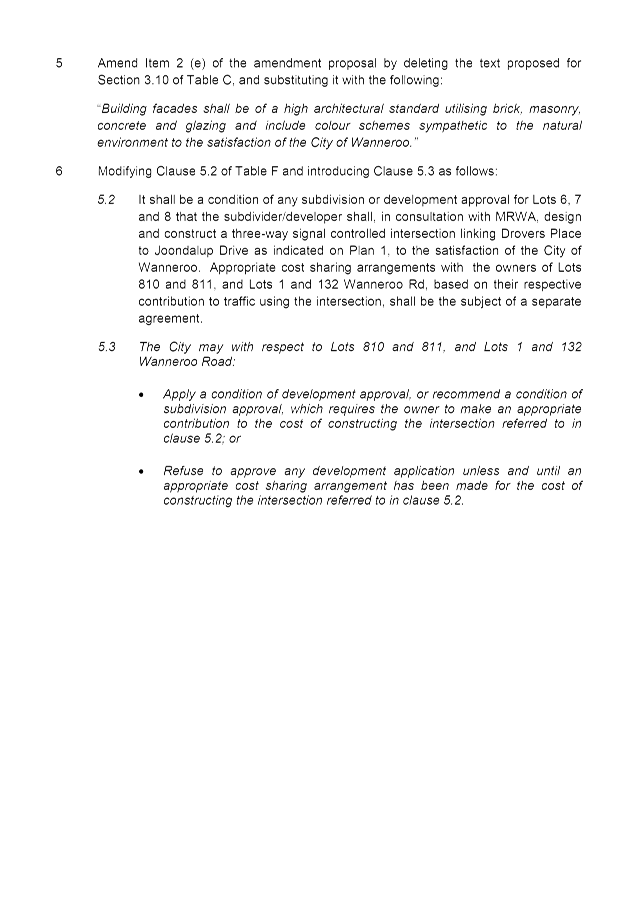
A minor change to the same provision allowing the use of concrete for building façades is supported by Administration, as concrete façades are capable of being treated in a manner that is sympathetic to the natural environment of Yellagonga Regional Park. Considering the above the following modified Provision 10 is recommended:
“Building facades shall be of a high architectural standard utilising brick, masonry, concrete and glazing and include colour schemes sympathetic to the natural environment to the satisfaction of the City of Wanneroo.”
Contribution toward Traffic Signals
Currently Table F (Section 5.1) of ASP 80 contains the following provision:
5.1 If business development of Lots 1 and 132 is proposed, in accordance with the structure plan, a condition of such development shall be that the subdivider/developer of Lots 1 and 132 Wanneroo Road in the Business Precinct, in consultation with MRWA, shall design and construct a four-way signal controlled intersection at the junction of Clarkson Avenue and Wanneroo Road, as indicated on Plan 1, to the specification and satisfaction of the City of Wanneroo.
As outlined in Attachment 2, the WAPC in its adoption of Amendment No. 5 had required modification to this provision, so that Table F (Section 5.1) of ASP 80 reads as follows:
“If business development of Lots 1 and 132 is proposed, in accordance with the structure plan, a condition of such development shall be that the subdivider/developer of Lots 1 and 132 Wanneroo Road, in consultation with MRWA, shall design and construct a four-way signal controlled intersection at the junction of Clarkson Avenue and Wanneroo Road, as indicated on Plan 1 to the specification and satisfaction of the City of Wanneroo. Appropriate cost sharing arrangements between landowners and any other authority or person will be the subject of a separate agreement.”
Administration does not object to the change to this clause, as it still requires the landowner of Lot 1 and Lot 132 to coordinate the design and construction of traffic signals at the Wanneroo Road/Clarkson Avenue as a condition of planning approval or subdivision. The term ‘any other authority’ as referred to in the revised clause could potentially include the City; however at the time such an agreement is prepared, the City could determine whether it should contribute towards the design and construction of the signalised intersection.
Changes to Clause 5.2 of Table F are discussed in the Report for Amendment No. 4, as also included on this Agenda. To ensure that the recommendations outlined in the traffic study are actioned, Administration recommends that changes to Clause 5.2 to Table F be adopted through Amendment No 5. The addition of Clause 5.3 of Table F should also be adopted through Amendment No. 5 for the same reason.
Update on Draft Amendment to DPS 2
When Council considered the WAPC modifications on Amendment No. 3 to ASP 80 at its 26 May 2015 Council Meeting (PS03-05/15), it resolved, in part, as follows:
“5. NOTES that Administration will provide an update in due course regarding a request from the Western Australian Planning Commission dated 8 April 2015 to rezone the Drovers Place Precinct Agreed Structure Plan No. 80 (Central Precinct) to ‘Business’ under District Planning Scheme No. 2.”
This resolution was made in light of correspondence received by the WAPC, dated 8 April 2015. In that correspondence, the WAPC requested the City to consider initiating an amendment to District Planning Scheme No. 2 (DPS 2) to normalise the zoning of the ASP 80 area under DPS 2. Administration is in the early stages of preparing the amendment, and intends to complete a draft document for Council’s consideration once this amendment (and Amendment No. 4 to ASP 80) is adopted by both Council and the WAPC.
Planning and Development (Local Planning Schemes) Regulations 2015
The Planning and Development (Local Planning Schemes) Regulations 2015 (the Regulations) were gazetted on 25 August 2015 and will take effect on 19 October 2015. As Council has been invited to make a decision prior to the date the Regulations take effect, the provision of the Regulations in making a decision on this amendment at this meeting do not apply.
After the Regulations take effect, the WAPC will be the sole determining authority of a structure plan amendment. That determination would be granted following a decision from the local government to recommend (or not recommend) adoption of the amendment. If Council do not make a decision on Amendment No. 5 at this Council Meeting, any future decision of Council on this amendment would be a ‘recommendation’ to the WAPC, rather than an ‘adoption’ as is currently the case under DPS 2.
As the amendment will be considered by the WAPC following the date the Regulations take effect, Administration’s recommendation does not make reference to documents being signed and sealed by the Director, Planning and Sustainability once certified by the WAPC.
Conclusion
Council at its meeting of 31 March 2015 (PS11-03/15) resolved to adopt Amendment No. 5 subject to modifications, and to forward the modified amendment document to the WAPC for its adoption and certification. On 29 May 2015, the WAPC advised Administration that it adopted Amendment No. 5 subject to modifications. The applicant submitted the modified amendment document by modifying some development provisions. As explained in the report above, Administration supports the modified amendment subject to modifications, which are outlined in Attachment 7.
Statutory Compliance
This Structure Plan amendment has been processed in accordance with the requirements of Part 9 of DPS 2.
Strategic Implications
The proposal aligns with the following objective within the Strategic Community Plan 2013 – 2023:
“3 Economy - Progressive, connected communities that enable economic growth and employment.
3.2 Growing Business - Our community is a preferred place for business to locate and grow.”
Risk Management Considerations
Nil
Policy Implications
Consideration of this amendment proposal has been made with regard to the following policies:
· The City’s Local Planning Policy 4.2: Structure Planning;
· Local Planning Policy 3.2: Activity Centres;
· Local Planning Policy 4.17: State Administrative Tribunal; and
· State Planning Policy 4.2: Activity Centres for Perth and Peel.
Financial Implications
Nil.
Voting Requirements
Simple Majority
That Council:-
1. Pursuant to Clauses 9.6.1 (b) of the City of Wanneroo District Planning Scheme No. 2, DETERMINES that Amendment No. 5 to Drovers Place Precinct Agreed Structure Plan No. 80 included as Attachment 4, submitted by TPG Town Planning, Urban Design and Heritage on behalf of Lakewide Pty Ltd is SATISFACTORY, subject to the recommended modifications listed in the Schedule of Modifications included as Attachment 7 being made to the satisfaction of the Manager, Planning Implementation;
2. Pursuant to Clause 9.6.1 of the City of Wanneroo District Planning Scheme No. 2, SUBMITS three copies of the modified Amendment No. 5 to Drovers Place Precinct Agreed Structure Plan No. 80 to the Western Australian Planning Commission for its adoption and certification;
3. Pursuant to Clause 9.6.5 of the City of Wanneroo District Planning Scheme No. 2, ADOPTS the duly modified Amendment No. 5 to Drovers Place Precinct Agreed Structure Plan No. 80;
4. NOTES the Schedule of Submissions received in respect of Amendment No. 5 to Drovers Place Precinct Agreed Structure Plan No. 80 included as Attachment 5, ENDORSES Administration’s comments and recommendations in response to those submissions, FORWARDS the Schedule of Submissions to the Western Australian Planning Commission and ADVISES the submitters of its decision; and
5. REQUIRES Administration to submit a report on the proposed amendment to the District Planning Scheme No. 2 to normalise the zoning of the Drovers Place Precinct Agreed Structure Plan No. 80 area under the City’s District Planning Scheme No. 2 once Amendment No. 4 and No. 5 to the Drovers Place Precinct Agreed Structure Plan No. 80 are adopted and certified.
Attachments:
|
1. |
Attachment 1 - Location Plan -Amendment 5 to ASP 80 |
15/39862 |
|
|
2. |
Attachment 2 - WAPC Decision on Amendment No. 5 to Drovers Place Precinct Structure Plan number 80 |
15/178932 |
|
|
3. |
NEW Attachment 3 - Extent of Proposed Changes - Table C (Section 3) of ASP 80 |
15/489908 |
|
|
4. |
Attachment 4 - REVISED Proposed Amendment No. 5 to Structure Plan No 80 - Without Explanatory Report |
15/197592 |
Minuted |
|
5. |
NEW Attachment 5 - Summary of Submissions - Amendment No. 5 to ASP 80 |
15/489903 |
Minuted |
|
6. |
Attachment 6 - Amendment 5 to ASP 80 |
15/475759 |
|
|
7. |
NEW Attachment 7 - Amendment No. 5 to ASP 80 |
15/489633 |
Minuted |
CITY OF WANNEROO Agenda OF Elected Members' Briefing Session 06 October, 2015 38
File Ref: 2957-04V01 – 15/415386
Responsible Officer: Director Planning and Sustainability
Disclosure of Interest: Nil
Attachments: 4
Issue
To reconsider Amendment No. 4 to Drovers Place Precinct Agreed Structure Plan No. 80 (ASP 80), in response to an invitation made by the State Administrative Tribunal (SAT).
|
Applicant |
Wakefield Planning |
|
Owner |
Goldrange Pty Ltd & Greenpark Asset Pty Ltd |
|
Location |
Lot 810 (1397) Wanneroo Road, Wanneroo Lot 811 (1387) Wanneroo Road, Wanneroo |
|
Site Area |
Lot 810 – 2.8009 hectares Lot 811 – 2.9488 hectares |
|
MRS Zoning |
Urban |
|
DPS 2 Zoning |
Urban Development |
|
ASP 80 Zoning |
Special Use |
Background
Amendment No. 4 to ASP 80 affects Lot 810 (1397) and Lot 811 (1387), Wanneroo Road, Wanneroo. A plan showing the location of Lot 810 and Lot 811 is provided as Attachment 1.
ASP 80 prescribes land use permissibility on Lot 810 and Lot 811, which ASP 80 currently zones as 'Special Use'. This zone currently applies to the 'Central Precinct' of ASP 80, which also includes Lot 1 (1369) and Lot 132 (1351) Wanneroo Road, Wanneroo, located to the south of Lot 810 and Lot 811.
Administration has also received a revised Amendment No. 5, following a determination made by the Western Australian Planning Commission (WAPC). Amendment No. 5 proposes substantial changes to the zoning (and subsequently land use permissibility) of the Central Precinct. Consideration of the revisions to the Amendment No. 5 proposal are part of a separate item in this Agenda. Amendment No. 4 has been prepared to provide additional modifications to ASP 80 not contemplated for in the revised Amendment No. 5 proposal, relating to Lot 810 and Lot 811 Wanneroo Road, Wanneroo.
Council's Previous Decision and SAT Proceedings
Council at its 14 October 2014 meeting (PS05-10/14) resolved to adopt Amendment No. 4 to ASP 80 (subject to modifications). However, after Council's decision, the applicant exercised their rights to seek a SAT review of Council's decision on Amendment No. 4.
Initially, the applicant had sought to have the matter reviewed through Mediation, which was arranged by the SAT and attended by the City’s officers in October and November 2014. Although the SAT issued Orders inviting the City to reconsider its decision at the 9 December 2014 Council Meeting, the applicant then requested this invitation be withdrawn, so that the matter could proceed to a Full Hearing. In preparing for the Full Hearing earlier this year, the City’s officers (and legal representative) made further arrangements with the applicant for the matter to be considered further at Mediation.
The matter was subsequently heard at a Mediation conference held over three days on 21 and 22 April and 14 May 2015. At the end of Mediation, it was agreed between the parties that:
· The modified Amendment No. 4 being prepared in a form that assumes adoption of the revised Amendment No. 5 proposal, and proposes modifications to ASP 80 beyond those contemplated in Amendment No. 5;
· In relation to the proposed permissibility of ‘Shop’ (refer to the Detail section below), the landowner of Lot 810 and Lot 811 will provide to the City supporting retail modelling, which will make the assumption that large format retailing in the Central Precinct will be permissible through the adoption of Amendment No. 5 (refer to the Report on Amendment No. 5 included in this Agenda). That submission will attempt to justify how that arrangement will not adversely impact on planned or existing centres even with an additional 3000m2 of shop retail net lettable area on Lot 810 and Lot 811 (subject to a minimum retail net lettable area of 200m2 per tenancy and a maximum retail net lettable area of 1500m2 per tenancy);
· A revised version of Amendment No. 4 would modify the provisions of ASP 80 to require the landowners of Lots 810 and 811 to make a contribution to the costs of signalising intersections required for the ASP 80 area. Modifications to the provisions would apply the principle that such a contribution would be proportional to the traffic which development on Lot 810 and Lot 811 would generate through the required signalised intersections; and
· The City, at officer level, being prepared to recommend to Elected Members a 28-day advertising period be undertaken, rather than 42 days as prescribed in the City’s Local Planning Policy 4.2: Structure Planning (LPP 4.2).
Following on from Mediation, Council now has an invitation – pursuant to section 31(1) of the State Administrative Tribunal Act 2004 – to reconsider the amendment proposal by no later than 13 October 2015.
Detail
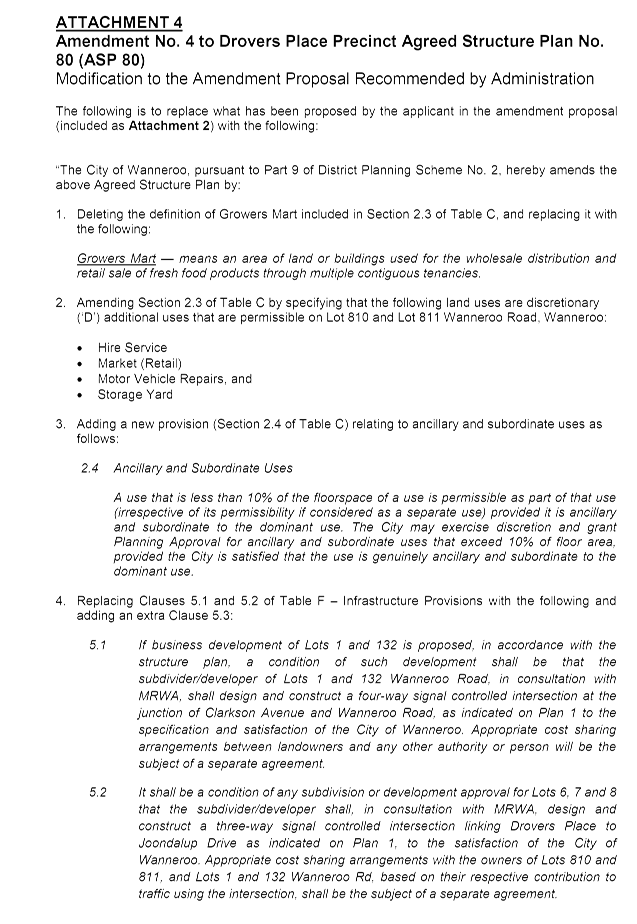
Council’s previous decision on Amendment No. 4 (made at its 14 October 2014 Council meeting) was to adopt the amendment, and to modify the ASP 80 text and map to:
1. Amend the general objectives included in Clause 7.0 of the structure plan to better respond to the ongoing planning of the structure plan area;
2. Amend the Statement of Intent relating to Lot 810 and Lot 811 to accord with State Planning Policy 4.2 – Activity Centres for Perth and Peel (SPP 4.2) – in particular to accord with the provisions of SPP 4.2 pertaining to 'out-of-centre development';
3. Create two distinct 'Special Use' zones within the Central Precinct. Special Use Zone 'A' had proposed to encompass Lot 1 and Lot 132, and Special Use Zone 'B' Lot 810 and Lot 811;
4. Increase the range of land uses capable of being approved on Lot 810 and Lot 811;
5. Modify the parameters associated with the permissibility of the ‘Storage Yard’, ‘Hairdresser’ and ‘Liquor Store’ land uses;
6. Introduce a definition for the ‘Costume Hire’ land use, and to modify the definition of the ‘Growers Mart’ land use; and
7. Insert a new provision pertaining to ‘Ancillary and Subordinate Uses’ within the Central Precinct.
Following the Mediation conferences that had occurred at the SAT, Administration received (and advertised) a revised version of Amendment No. 4 that now proposes the following changes to the ASP 80 text:
1. Minor changes to the wording of the Statement of Intent for the Central Precinct;
2. Modifying the Growers Mart definition, to the same as was adopted by Council in its previous deliberations of the amendment;
3. Adding the following land uses as discretionary (‘D’) uses on Lot 810 and Lot 811:
· Hire Service;
· Market (Retail);
· Motor Vehicle Repairs;
· Self-Storage Units; and
· Shop (the parameters proposed for this use prescribe a minimum retail net lettable area (NLA) per tenancy of 200m2, a maximum retail NLA per tenancy of 1500m2 and a maximum overall NLA of 3000m2).
4. Inserting a provision on ‘Ancillary and Subordinate Uses’ in the Central Precinct, the same as was adopted by Council in its previous deliberations of the amendment.
The revised amendment proposal for Council's consideration, submitted by the applicant following the SAT Mediation conference, is included as Attachment 2.
Consultation
Prior to Council’s initial adoption of Amendment No. 4 at its 14 October 2014 meeting, the amendment was advertised for public comment by means of an on-site sign, an advertisement in the Wanneroo Times newspaper, display on the City’s website and letters to adjoining landowners. At that time, Administration received six submissions, which were summarised and responded to by Administration in the report presented to the 14 October 2014 Council Meeting (PS05-10/14).
Clause 9.5 of DPS 2 requires adequate publicity of a structure plan proposal, prior to it being considered by Council. Although advertising was undertaken for the version of the amendment previously considered by Council, Administration considered that the revised version of Amendment No. 4 required advertising for the following reasons:
· Amendment No. 4 as previously advertised (from 15 July 2014 to 26 August 2014) proposed ‘Shop’ as a discretionary (or ‘D’) use on Lot 810 and Lot 811. The advertised version of Amendment No. 4 proposed the permissibility of this land use subject to ‘Shop’ occupying a minimum retail net lettable area of 200m2 per tenancy, and for such tenancies to not sell food or groceries. The parameters for ‘Shop’ that are now being sought have changed significantly – in particular to remove the restrictions on selling food and groceries. A floor space limit for individual shops and an overall cap is also being proposed, which was not proposed in the previous version of the amendment that was advertised; and
· Retail Impact Assessments that have been provided by the applicant (or commissioned by Administration) have not been advertised.
Administration subsequently advertised the amendment proposal (and supplementary retail impact assessment documents) for a period of 28 days from 21 July to 18 August 2015. Advertising was undertaken by means of an on-site sign, an advertisement in the Wanneroo Times newspaper, display on the City’s website and letters written to adjoining landowners. During the advertising period, Administration received eight submissions. The key issues of the submissions are as follows:
· The land use ‘Shop’ is not appropriate to be permissible on Lot 810 and Lot 811, which is identified as an ‘out-of-centre’ development, and
· Opposition to the proposed change to the Statement of Intent of the Central Precinct.
A summary of submissions received and Administration's responses to each is provided in Attachment 3. It is noted that three submissions were made by the same submitter representing three landowners and listing the same issues. Therefore these three submissions have been combined as one submission in the schedule.
Comment
Amendment No. 4 proposes changes to the ASP 80 text, as outlined in the ‘Detail’ section above. The comments below expand and further discuss the key matters associated with the amendment proposal:
Changes to the Statement of Intent
As outlined in the ‘Detail’ section, the amendment proposes minor modifications to the Statement of Intent for the Central Precinct. The proposed Statement of Intent (with emphasis on the proposed change) is as follows:
“The intent of the Central Precinct is to accommodate warehouses, showrooms, trade and professional services and small scale complementary and incidental retailing uses, as well as providing for retail and commercial businesses which require large areas such as bulky goods and category/theme‐based retail outlets that provide for the needs of the community but which due to their nature are generally not appropriate to or cannot readily be accommodated in a commercial area.”
The Statement of Intent currently within ASP 80 (without the word ‘readily’) was adopted by Council and the WAPC in deliberations of Amendment No. 3. As outlined in a previous Council Report regarding the adoption of Amendment No. 3 (PS03-05/15), the Statement of Intent draws from the language used in the intent for the Business Zone as outlined in Clause 3.6.1 of DPS 2. Also as outlined in that previous Report, the Statement of Intent is to coincide with a request from the WAPC for the City to normalise the zoning in the ASP 80 area under DPS 2, and in particular to rezone the ASP 80 Central Precinct to ‘Business’ under DPS 2. As outlined in the Amendment No. 5 Report included on this Agenda, a draft DPS 2 amendment will be presented to Council once the assessment of Amendment No. 4 and No. 5 are finalised.
The application of the word ‘readily’ into the Statement of Intent is inconsistent with the anticipated rezoning of the ASP 80 Central Precinct to Business under DPS 2. Inserting the word would result in a misalignment of the Statement of Intent for the ASP 80 Central Precinct and the Intent for the Business Zone as outlined in DPS 2. Therefore, the proposed change to the Statement of Intent is not supported.
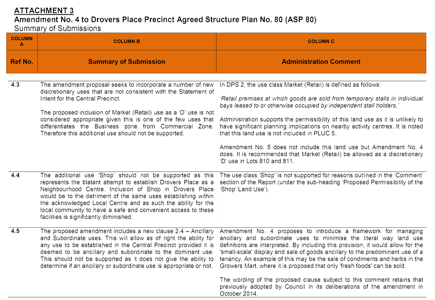
Growers Mart Definition
Council in its previous deliberations of Amendment No. 4 made at the 14 October 2014 Council meeting adopted the following definition for the Growers Mart land use:
Growers Mart – means an area of land or buildings used for the wholesale distribution and retail sale of fresh food products through multiple contiguous tenancies.
The definition required by the WAPC through its modifications to Amendment No. 5 resolved to retain the current ASP 80 definition for this land use, which is as follows:
Growers Mart – means any land or buildings used for the wholesale distribution and retail sale of primary products including fruit and vegetables, meat, fish, bread.
Administration liaised with the officers at the Department of Planning regarding the definition for Growers Mart adopted by the WAPC. In its response, the Department advised that the WAPC decision retained the definition as was adopted through a previous amendment to ASP 80 (Amendment No. 1, adopted in August 2013). However, the Department also advised that it did not have a strong view on the definition pursued by the applicant and would accept it if Council were to adopt it.
To be consistent with the previous Council decision on this matter, Administration recommends that the definition of Growers Mart as proposed by the applicant be adopted by Council through this consideration of the amendment proposal.
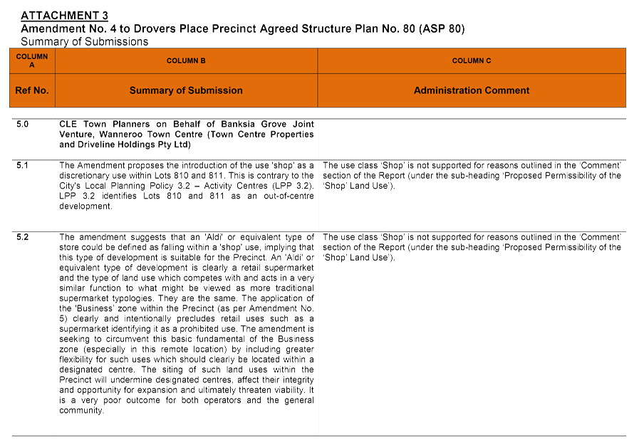
Proposed Permissibility of the ‘Shop’ Land Use
City’s Pursuit for Retail Potential Analysis
During the SAT Mediation conferences attended by the City’s officers in October and November 2014, the SAT issued Orders inviting the applicant to provide the City with a retail impact assessment that investigated the development of an additional 5,000sqm of PLUC 5 floorspace on Lot 810 and Lot 811, and likely impacts of this floorspace on designated activity centres. PLUC 5 land uses are ‘shop-retail’ uses prescribed in the Department of Planning’s publication ‘Commercial Land Use Survey 1997’, and include uses listed in DPS 2 such as Shop, Hairdresser, Restaurant, some Showroom development, Liquor Store, Take-Away Food Outlet as well as the ‘Growers Mart’ land use as defined in ASP 80.
It was identified by Administration at that time that there was approximately 3,000sqm of PLUC 5 floorspace occupying (or approved to occupy) the development on Lot 810 and Lot 811. That floorspace is occupied by the existing Growers Mart, restaurant, Pet City showroom, and will later also be occupied by an approved liquor store and another restaurant.
The applicant’s retail impact assessment at that time accompanied a revised amendment proposal. Although a retail impact assessment and revised amendment proposal were received by Administration at the time, the applicant nominated for the matter to proceed to Full Hearing before Administration could consider the impacts and report to Council. In preparation for such a Hearing (which was later vacated for further Mediation, as outlined in the ‘Background’ section above), Administration commissioned the assistance of an external retail expert to identify the amount of PLUC 5 floorspace that could occupy the ASP 80 Central Precinct, without a significant detriment on other centres. The response received concludes that 13,000sqm of PLUC 5 land uses could be tolerable within the ASP 80 Central Precinct, without a significant detrimental economic impact on nearby existing or planned activity centres.
The conclusions from Administration’s appointed retail expert was based on a mathematical model, on how centres draw customers based on household expenditure, size of activity centres (particularly the attraction that the size has on drawing customers), population and travel time. The mathematical model has not been derived from provisions of State Planning Policy, but rather is based on how trade in other activity centres would be impacted should 13,000sqm of PLUC 5 land uses be established in the ASP 80 Central Precinct.
Further to the modelling provided, Administration’s appointed retail expert provides the following statements in relation to the provisions of SPP 4.2:
· The Drovers Central Precinct is not an ideal site for expansion, with its traffic access and circulation problems, and poor design (lack of a main street and public spaces). Access and amenity are core aspects of the criteria contained in SPP 4.2 and should be considered in conjunction with the potential trade impacts of a proposed retail expansion;
· Given the proposed scale of the Drovers Central Precinct, a traffic impact assessment should potentially be prepared to support the amendment (this was completed as outlined later in the Report); and
· There is a limited residential catchment surrounding the Drovers Central Precinct. Wanneroo Road also presents as a barrier for pedestrians from neighbourhoods to the east (Carramar and Tapping), particularly at peak traffic times. The implementation of new retail floor space should ideally occur in locations providing safe and convenient access, encouraging bicycle and pedestrian access.
The version of the advertised amendment now subject to consideration contemplates an additional use of ‘Shop’ (as listed in Table 1 of DPS 2), occupying a maximum floor area of 3,000sqm across Lot 810 and Lot 811. It does not contemplate a prescribed maximum addition to PLUC 5 uses generally, as was modelled by Administration’s appointed retail expert. There is an inconsistency between the retail modelling previously commissioned by Administration, as Amendment No. 4 now only proposes a maximum floorspace for the ‘Shop’ land use, and not a maximum floorspace for PLUC 5 uses generally.
Applicants Retail Impact Assessment
On review of the applicant’s most recent retail impact assessment (dated May 2015); Administration has identified the following key points:
· The assessment assumes no PLUC 5 will be permitted on the adjoining Lot 1 and Lot 132. However, the WAPC’s adoption of Amendment No. 5 requires the ASP 80 Central Precinct (including Lot 1 and Lot 132) to be rezoned to ‘Business’. Although the Business zone does not permit the establishment of the ‘Shop’ land use, it does allow for the establishment of other PLUC 5 uses; such as Hairdressers, Restaurants, Liquor Stores and Take-Away Food Outlets.
· The applicant’s retail impact assessment concludes with a statement that outlines that ‘anchor uses’ such as full line supermarkets should not be located in ‘out-of-centre’ locations, such as in the amendment area. The applicant has made it clear of their intention to attract the Aldi supermarket to Lot 810 or Lot 811, which would occupy up to 1,500sqm. Although the applicant has argued that Aldi is not a full line supermarket (for example, Aldi only has a limited number of lines available for sale at one time), the proposed ‘Shop’ use does not provide conditions that would limit the amount of line sold in a ‘Shop’ of 1,500sqm. The amendment proposal (if adopted) would not restrict the establishment of full line supermarkets occupying up to 1,500sqm on the site (such as a Farmer Jacks or Supa IGA).
State Planning Policy Considerations
The WAPC’s SPP 4.2 states as follows:
The responsible authority should not support activity centre structure plans or development proposals that are likely to undermine the established and planned activity centre hierarchy.
Elsewhere in SPP 4.2, the following is also stated:
“The responsible authority should not support activity centre or other structure plans, scheme amendments or development proposals that are likely to:
· Undermine the activity centre hierarchy or the policy objectives;
· Result in deterioration in the level of service to the local community or undermine public investments in infrastructure and services; or
· Unreasonably affect the amenity of the locality through traffic or other impacts.
The amendment proposal (if adopted) would facilitate the approval of development proposals for ‘shop’ types that are likely to undermine the established and planned activity centre hierarchy. Adopting the amendment proposal would give a ‘shop’ type (such as a 1,500sqm supermarket chain) an option to locate on Lot 810 or Lot 811 rather than in an activity centre. Should a shop then choose to locate on Lot 810 or Lot 811 if such an option is available, it could delay the establishment of shop uses being established in existing or planned activity centres.
Administration considers that development of existing and planned centres should be encouraged, as these centres are located adjacent to residential development, and provide a greater focus for pedestrian amenity than the development situated on Lot 810 and Lot 811.
What also needs to be considered is should Council adopt the amendment with the ‘Shop’ land use being permissible on Lot 810 and Lot 811 as proposed, it is fair and reasonable to expect that the landowner of Lot 1 and Lot 132 be granted the same land use permissibility. Should that landowner pursue what the landowner of Lot 810 and Lot 811 is pursuing in Amendment No. 4 – and should up to 6,000sqm of ‘Shop’ in the ASP 80 Central Precinct then become permissible – this would exacerbate the undermining of other nearby existing and planned activity centres.
Considering the above it is recommended that the Shop use class be considered as ‘not permissible’ (X) in Drovers Place.
Other matters
Traffic – Infrastructure Upgrades
A traffic study was commissioned by Administration to consider whether the existing ASP 80 provisions relating to the provision of traffic signals at the Wanneroo Road/Clarkson Avenue and the Joondalup Drive/Drovers Place intersections were equitable on the landowners of Lot 810, Lot 811, Lot 1 & Lot 132 Wanneroo Road as well as the landowner of Lots 6, 7 and 8 Drovers Place. The study prepared assumes that residential development would be undertaken on Lot 6, Lot 7 and Lot 8, as was proposed in Amendment No. 2 to ASP 80. Although Council made a resolution to not adopt Amendment No. 2 at its 26 May 2015 Council Meeting (PS06-05/15), the traffic study was requested prior to Council making that decision.
What both Administration and the traffic study have identified is that the provisions of ASP 80 do not prescribe an obligation on the landowner of Lot 810 and Lot 811 to contribute to the signalisation of either of the above-mentioned intersections. What the traffic study concluded is that there should be an onus on the landowner of Lot 810 and Lot 811 to contribute to the design and construction of traffic signals at the subject intersections, as development on these lots could generate a significant proportion of traffic that would use the proposed signalised intersections. Administration agrees that any such contribution should be proportionate to the traffic that this development generates through the intersections, which could be identified at the time a development proposal is lodged with the City
Changes to Section 5.1 of Table F (relating to the signalisation of the Wanneroo Road/Clarkson Avenue intersection) are considered in Amendment No. 5, and therefore are further discussed in that Report, included on this Agenda. It is noted that this change proposed through Amendment No. 5 is not inconsistent with the findings of the traffic study.
In regard to Drovers Place/Joondalup Drive intersection – and the provisions of Clause 5.2 of Table F – the current provision is as follows:
5.2 The subdivider/developer of Lots 6, 7, & 8 in the Western Precinct shall, in consultation with MRWA, design and construct a three‐way signal controlled intersection linking Drovers Place to Joondalup Drive, as indicated on Plan 1 and construct an emergency vehicle access to the existing fire station on Lot 12462 to the specification and satisfaction of the City of Wanneroo.
The traffic study notes that under the change in traffic generation resulting from the amendments to ASP 80 (which included Amendment No. 2), approximately 20-30% of generated traffic using the Drovers Place/Joondalup Drive intersection was forecast to originate from Lot 6, Lot 7 and Lot 8 during the AM & PM peak period, with a significant balance coming from Lot 810 & Lot 811. Based on these proportions, the traffic study concluded that it is not equitable on the land owner of Lot 6, Lot 7 and Lot 8 to incur the full cost and responsibility of providing the new signalised intersection as required under ASP 80, should Amendments No. 4 and No. 5 be adopted. It is therefore recommended that Section 5.2 of Table F be modified as follows:
5.2 It shall be a condition of any subdivision or development approval for Lots 6, 7 and 8 that the subdivider/developer shall, in consultation with MRWA, design and construct a three-way signal controlled intersection linking Drovers Place to Joondalup Drive as indicated on Plan 1, to the satisfaction of the City of Wanneroo. Appropriate cost sharing arrangements with the owners of Lots 810 and 811, and Lots 1 and 132 Wanneroo Road, based on their respective contribution to traffic using the intersection, shall be the subject of a separate agreement.
An additional provision stipulating how a financial contribution (or an agreement relating to financial contribution) should be obtained from the relevant landowners for the cost of the signalised intersections is provided in a proposed additional clause (Clause 5.3) to Table F. That proposed additional clause is provided for below:
5.3 The City may with respect to Lots 810 and 811, and Lots 1 and 132 Wanneroo Rd,:
· Apply a condition of development approval, or recommend a condition of subdivision approval, which requires the owner to make an appropriate contribution to the cost of constructing the intersection referred to in clause 5.2; or
· Refuse to approve any development application unless and until an appropriate cost sharing arrangement has been made for the cost of constructing the intersection referred to in clause 5.2.
Planning and Development (Local Planning Schemes) Regulations 2015
The Planning and Development (Local Planning Schemes) Regulations 2015 (the Regulations) were gazetted on 25 August 2015 and will take effect on 19 October 2015. As Council has been invited to make a decision prior to the date the Regulations take effect, the provision of the Regulations in making a decision on this amendment at this meeting do not apply.
After the Regulations take effect, the WAPC will be the sole determining authority of a structure plan amendment. That determination would be granted following a decision from the local government to recommend (or not recommend) adoption of the amendment. If Council do not make a decision on Amendment No. 4 at this Council Meeting, any future decision of Council on this amendment would be a ‘recommendation’ to the WAPC, rather than an ‘adoption’ as is currently the case under DPS 2.
As the amendment will be considered by the WAPC following the date the Regulations take effect, Administration’s recommendation does not make reference to documents being signed and sealed by the Director, Planning and Sustainability once certified by the WAPC.
Conclusion
Council at its meeting of 14 October 2014 resolved to adopt Amendment No. 4 to ASP 80 subject to modifications. The applicant subsequently appealed to the SAT to review Council’s decision; and as part of that review, Council now has an invitation from the SAT to reconsider its decision.
Administration supports the proposed amendment, subject to modifications. In particular, modifications are recommended so that:
· The Statement of Intent for the ASP 80 Central Precinct remains unchanged from that previously adopted by Council in its deliberations of Amendment No. 3;
· The land use ‘Shop’ remains a prohibited use on Lot 810 and Lot 811; and
· The landowner of Lot 810 and Lot 811 contributes toward the design and construction of traffic signals at the Wanneroo Road/Clarkson Avenue and the Joondalup Drive/Drovers Place intersections. Contribution would be dependent on the proportion of traffic using the intersections, generated from the development on Lot 810 and Lot 811.
It is recommended that the modified amendment be adopted and forwarded to the WAPC for its adoption and certification
Statutory Compliance
In accordance with Section 31 of the State Administrative Tribunal Act 2004, the SAT has invited Council to reconsider the conditions of its decision on or before 13 October 2015.
The Structure Plan amendment has been processed in accordance with the requirements of DPS 2. Clause 9.6.1 of DPS 2 provides that following advertisement of a Structure Plan amendment, Council may refuse to adopt the Amendment or resolve that the amendment is satisfactory with or without modifications. It is recommended that Council adopt Amendment No. 4 to Drovers Place Precinct Agreed Structure Plan No. 80 subject to modifications.
Strategic Implications
The proposal aligns with the following objective within the Strategic Community Plan 2013 – 2023:
“4 Civic Leadership - Working with others to ensure the best use of our resources.
4.2 Working With Others - The community is a desirable place to live and work as the City works with others to deliver the most appropriate outcomes.”
Risk Management Considerations
The applicant may exercise their rights to seek further review of the matter at the SAT, following Council's decision. Should that occur, the matter may then proceed to Full Hearing, where the SAT would reconsider the issues in dispute.
Policy Implications
Consideration of this amendment proposal has been made with regard to the following policies:
· The City’s Local Planning Policy 4.2: Structure Planning;
· Local Planning Policy 3.2: Activity Centres;
· Local Planning Policy 4.17: State Administrative Tribunal; and
· State Planning Policy 4.2: Activity Centres for Perth and Peel.
Financial Implications
Financial implications would be dependent on the decision of Council and the applicant's further action arising there from.
Should the matter proceed to a Full Hearing at the SAT, the City is likely to incur further costs in legal and expert fees. These costs do not include the substantial Administration time involved to date and which will be further required should the matter proceed to Full Hearing.
Voting Requirements
Simple Majority
That Council:-
1. RESOLVES that the revised Amendment No. 4 to Drovers Place Precinct Agreed Structure Plan No. 80, included as Attachment 2 and dated 29 June 2015, submitted by Wakefield Planning on behalf of Goldrange Pty Ltd & Greenpark Asset Pty Ltd is NOT SUPPORTED in its current form;
2. Pursuant to Section 31 (2) (c) of the State Administrative Tribunal Act 2004 and notwithstanding Item 1 above, SETS ASIDE its decision in relation to Amendment No. 4 made at its meeting of 14 October 2014, and pursuant to Clause 9.6.1 (b) of the City of Wanneroo District Planning Scheme No. 2, RESOLVES that the revised Amendment No. 4 to Drovers Place Precinct Agreed Structure Plan No. 80, included as Attachment 2 and dated 29 June 2015, submitted by Wakefield Planning on behalf of Goldrange Pty Ltd & Greenpark Asset Pty Ltd is SATISFACTORY, subject to the recommended modifications outlined in Attachment 4 being made to the satisfaction of the Manager, Planning Implementation;
3. Pursuant to Clause 9.6.1 of the City of Wanneroo District Planning Scheme No. 2, SUBMITS three copies of the modified Amendment No. 4 to Drovers Place Precinct Agreed Structure Plan No. 80 to the Western Australian Planning Commission for its adoption and certification;
4. Pursuant to Clause 9.6.5 of the City of Wanneroo District Planning Scheme No. 2, ADOPTS the duly modified Amendment No. 4 to Drovers Place Precinct Agreed Structure Plan No. 80; and
5. NOTES the Schedule of Submissions received in respect of Amendment No. 4 to Drovers Place Precinct Agreed Structure Plan No. 80 included as Attachment 3, ENDORSES Administration’s comments and recommendations in response to those submissions, FORWARDS the Schedule of Submissions to the Western Australian Planning Commission and ADVISES the submitters of its decision.
Attachments:
|
1. |
NEW Attachment 1 - Lots 810 & 811 (1397 & 1387) Wanneroo Road |
14/280083 |
|
|
2. |
Amendment No. 4 to ASP 80 - Attachment 2 |
15/464190 |
Minuted |
|
3. |
Attachment 3 - Summary of Submissions for the Amendment No. 4 Report |
15/489616 |
Minuted |
|
4. |
Attachment 4 - Administration s Recommended ~ Amendment No. 4 to ASP 80 |
15/489752 |
Minuted |
CITY OF WANNEROO Agenda OF Elected Members' Briefing Session 06 October, 2015 64
File Ref: 2965 – 15/421965
Responsible Officer: Director Planning and Sustainability
Disclosure of Interest: Nil
Attachments: 3
Issue
To consider the submissions received during the public advertising of Amendment No. 102 to District Planning Scheme No.2 (DPS 2) and the adoption of that amendment and the associated cost sharing arrangements.
|
Applicant |
City of Wanneroo |
|
Owner |
Various |
|
Location |
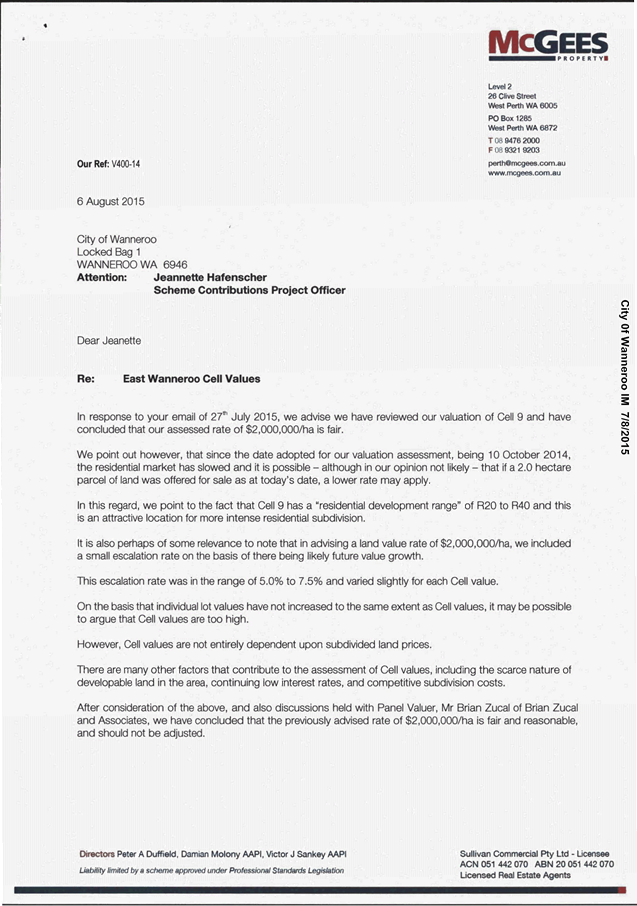
East Wanneroo Cell 9 |
|
Site Area |
200 hectares approx. |
|
MRS Zoning |
Urban |
|
DPS 2 Zoning |
Urban Development |
Background
Council, at its meeting of 30 June 2009, considered the draft East Wanneroo Cell 9 – East
Landsdale Local Structure Plan No. 57 (LSP 57) following public consultation and, in part,
resolved as follows (Item PS09-06/09):
“That Council:
5. REQUIRES the Director, Planning and Sustainability to submit a report to Council to consider amending the City of Wanneroo District Planning Scheme No. 2 to:
a) Introduce specific provisions for the East Wanneroo Cell 9 to determine the Nett Residential Area and the potential lots to which the Infrastructure Cost Per Lot would apply based on the proposed average lot size of 500m2;
b) Define the “basic standard of public open space development” as indicated in Schedule 9, Clause 2.6 of DPS 2; and
c) Investigate the prospect of including additional developer contribution costs for the Cell 9 area, as outlined in this report, in response to submissions received during advertising of the East Wanneroo Cell 9 – East Landsdale Local Structure Plan.”
Council, at its meeting of 26 June 2012 (PS01-06/12), considered a proposal (Amendment No. 102) to amend Part 10 and Schedule 9 of DPS 2 to include additional provisions applicable to East Wanneroo Cell 9 as per the following:
· “An increase in the estimated lot yield for Cell 9 from 9 lots per hectare to 13 lots per hectare.
· The development of Public Open Space (POS) to a basic standard.
· Introduce the cost of acquiring 100% of the wetland core of the ‘Conservation Category Wetland’ located on Lots 72, 73 and 74 Queensway and of the ‘Resource enhancement Wetland’ located on Lots 55 and 56 Alexander Drive, at the rate of 20% of the englobo land value for the contribution area.
· The cost of acquisition of the land for buffer and landscaping of the buffer along the eastern boundary abutting Alexander Drive.
· The acquisition of land for the 5000m2 Community Purpose site and the design and construction of a Community Centre on the Community Purpose site.”
Amendment No. 102 was advertised and a subsequent report was presented to Council at its meeting on 30 April 2013 (PS06-04/13), where it was resolved (subject to some minor changes) to “FORWARD the Amendment documentation to the Western Australian Planning Commission for its consideration REQUESTING the Hon Minister for Planning grant final approval to the Amendment”:
The Western Australian Planning Commission (WAPC) in its correspondence of 17 February 2015 advised that the Minister for Planning has directed the City to re-advertise the amendment for a period of 42 days with a schedule of estimated cost sharing arrangements for the infrastructure items.
Creative Design + Planning, consultants in Town Planning (the consultant), were engaged by the City under a prefunding arrangement with Stockland Pty Ltd to prepare the Cost Sharing Arrangements (CSA) document, which:
· Provides costings (actual or estimates) for cell works currently allowed for by DPS 2;
· Provide estimated costings for the additional cell works proposed in Amendment No. 102; and
· Determined the ‘assessed value’ of land, total cell works estimates and Infrastructure cost per lot in Cell 9.
Council, at its meeting on 26 May 2015 (PS05-05/15) resolved to re-advertise Amendment No. 102 (as follows) and the associated Cost Sharing Arrangements:
“Part 10
a) subclause 9.12.7 be amended to replace the integer ‘8’ with ‘9’;
b) subclause 10.5.2(a) be amended as follows:
Public Open Space shall include:
a) all community purpose sites except in Cell 9;
c) second sentence of sub clause 10.6.2 be reworded as follows:
“This will be calculated by determining the number of hectares in the Area of a Cell and multiplying that area by 9 in the case of Cells 1 to 6 and multiplying that area by 13 in the case of Cell 9.”
d) subclause 10.6.3 be amended to redefine variables ‘B(1’) and ‘D’ of the formulae to calculate the Infrastructure Cost Per Lot as follows:
“B(1) = in the case of Cells 1 to 6 the lots produced at the rate of 9 lots per hectare for the Area equivalent of the land holding of an owner, and in the case of Cell 9 at the rate of 13 lots per hectare for the Area equivalent of the land holding of an owner; and
D = in the case of Cells 1 to 6 the number of lots to be produced to achieve 9 lots per hectare for the Area equivalent of the unsubdivided balance area of a Cell, and in the case of Cell 9 the number of lots to be produced to achieve 13 lots per hectare for the Area equivalent of the unsubdivided balance area of that Cell.”; and
e) the last sentence of subclause 10.6.4(a) be deleted and replaced with the following sentences:
“This shall be calculated by Council by dividing the total area of the lot by 450m2 to derive a lot potential for the lot in Cells 1 – 6. In the case of Cell 9 this shall be calculated by dividing the total area of the lot by 500m2 to derive a lot potential for the lots in that Cell.”
Schedule 9
f) To include the following provisions in Clause 3 under Cell 9:
The cost of acquiring 100% of the designated wetland core of the ‘Conservation Category Wetland’ located on Lots 72, 73 and 74 Queensway and of the ‘Resource Enhancement Wetland’ located on Lots 55 and 56 Alexander Drive, at the rate of 20% of the englobo land value for the contribution area, as determined under the provisions of Part 10 of the Scheme.
The cost of acquisition of the land for buffer and landscaping of the buffer along the eastern boundary abutting Alexander Drive.
Community Purpose Site:
· The acquisition of land for the 5000m2 Community Purpose site;
· Design and construction of a Community Centre on the Community Purpose site.
Detail
The Minister directed that Amendment No. 102 be re-advertised along with a schedule of estimated cost of all items. The following summary of costs represents the total cost of the cell works that were advertised. The highest cost relates to the acquisition and development of 10% public open space under the Agreed Structure Plan ($57 million). The other costs primarily relate to land acquisition and construction costs for District Distributer Roads ($9 million), Alexander Drive Buffer (Telstra Buffer - $3.5 million) and a community facility ($3.7 million).
|
Cell Works |
Advertised Cell Cost |
|
Existing (Schedule 9 of DPS 2) |
|
|
Roads |
9,079,078 |
|
POS Land |
44,386,760 |
|
POS Development |
12,737,660 |
|
LSP Preparation |
862,776 |
|
Administration |
500,000 |
|
|
|
|
SUB TOTAL |
67,566,274 |
|
Estimated Lot Yield (13 lots/ha) |
2,361 |
|
Estimated Infrastructure Cost Per Lot |
28,618 |
|
Proposed (Amendment 102) |
|
|
Wetland Core |
492,800 |
|
Alexander Drive Buffer |
3,449,160 |
|
Community Site and Building |
3,740,000 |
|
|
|
|
SUB TOTAL |
7,681,960 |
|
TOTAL |
75,248,234 |
|
Estimated Lot Yield (13 lots/ha) |
2,361 |
|
Estimated Infrastructure Cost Per Lot |
31,871 |
Interim Developer Contribution Scheme Arrangements
Land within the East Wanneroo Cell 9 (Structure Plan No. 57) has for many years been developing without an adopted infrastructure cost per lot. As such, Administration has secured contributions on an interim basis. Interim arrangements with subdividers involved an estimate of $30,000 per lot, plus a 30% contingency. Developers have secured interim arrangements through cash contributions, Bank Guarantees and/or deeds of agreement pending the finalisation of the cost estimates.
It is intended that the detailed estimate of costs can now be adopted by Council (i.e. without contingency) for this cell.
Consultation
In accordance with the Council’s previous decisions, the amendment was referred to the Environmental Protection Authority (EPA) for comment. On 12 November 2012, the EPA advised the City that the scheme amendment did not warrant an environmental assessment.
The Western Australian Planning Commission's (WAPC's) consent to advertise the amendment was not required. A 42-day public advertising period was carried out between 9 June and 21 July 2015 by way of four on-site signs, advertisements in the local newspaper, a notice in the Civic Centre and on the City’s website. The City also wrote to all landowners within the cell yet to subdivide their land and those subdividers that have already subdivided and have entered into interim developer contribution arrangements with the City.
The City received four submissions at the close of the advertising period, the details of the submissions together with Administration's response is included as Attachment 1.
Comment
In addition to the summary of submissions in Attachment 1, the salient issues are discussed below;
Compensation for wetland core
Two objections were noted against the inclusion of the wetland core as a cell work. The intention of Amendment No. 102 is to compensate the landowner at 20% of the englobo value for land. Council as part of its previous consideration of Amendment No. 102 (30 April 2013) resolved to retain the 20% compensation for the wetland core area (PS06-04/13). Again, it is recommended that compensation be retained in Amendment No. 102 to maintain consistency with the City of Wanneroo Policy LPP4.1: Wetlands.
LPP4.1 seeks to manage and protect the environmental attributes of wetlands. LPP4.1 provides for the following;
“11.1. Land identified in planning proposals for protection as a wetland or wetland buffer shall be ceded free of cost, unless a developer contribution arrangement is in place for acquisition of that land as a shared cost, in accordance with the following provisions:
a. For the wetland– the cost of acquiring 100 percent of the designated wetland core, at the rate of 20 percent of the englobo land value for the contribution area, as determined by a licensed valuer”.
It should be noted that the Department of Planning has indicated “that previous decisions of the Minister, conservation assets are not considered appropriate for inclusion in a DCP” and accordingly it is unlikely that the wetland cores can be supported for inclusion in the cost sharing arrangements. Notwithstanding, any determination that the Minister may make, Administration has recommended the inclusion of this cell work into the cost sharing arrangements in accordance with LPP4.1. Should the Minister make this determination, the City will need to further consider the modification to Amendment No. 102 and amend the cost estimates for the cell, if required.
Proposed Land Values
Council received a submission indicating that the proposed land values are high.
In accordance with Clause 10.14.3 of DPS 2, the City engaged two valuers, which formed a valuation panel. The valuation panel recommended that a valuation of $2,000,000 per hectare should be applied. In accordance with clause 10.14.3 (c), the City referred the submission to the valuation panel for comment and has received a response (refer Attachment 2). The response provided by the Valuation Panel indicates that it is possible that land values may have slowed, however, concluded that the proposed rate of $2,000,000 is fair and reasonable.
The Valuation Panel, however, also advised that an escalation of between 5% and 7.5% was included on the basis of future growth in land values. Given approximately half of all POS within the cell has already been created (and will be credited to the subdividers), an escalation is not recommended for inclusion into the initial adoption of the contribution scheme costs.
In accordance with Clause 10.14.3(c) of DPS 2,
“(c) The City shall as soon as possible consider all submissions made on the Proposed Value and may refer any submission to the Valuation Panel for comment, but where a submission is accompanied by expert valuation advice based on the valuation principles contained in this Part, it shall be referred by the City to the Valuation Panel for comment. Having considered the submissions and any comment from the Valuation Panel, the Council shall fix upon the value to be applied under this clause (“the Assessed Value”) until the next Assessed Value has been determined”.
In accordance with the above, Administration has considered the comments from the objector and the valuation panel, and has recommended that the 5% escalation should not be included into the assessed value. The deletion of the 5% escalation results in a proposed value of $1.9 million.
Road Costs
As a result of the submissions received, administration has further investigated and revised the extent of the road construction costs. For the most part, the East Wanneroo Cell 9 structure plan has benefited from significant state funding for the upgrading of the abutting regional roads. However, there are several municipal recoupments for ‘cell works’ that are required, including the construction of Hepburn Avenue ($964,655) and Gnangara Road ($1,051,545). The remaining cost estimates are primarily associated with the future acquisition and construction of arterial road intersections to Gnangara Road, Alexander Drive and Hepburn Avenue, drainage and dual use paths associated with these regional roads.
Deletion of the Gnangara Road MRS Road Widening
As a result of submissions received, the City has considered the deletion of the MRS road widening located on the southern side of Gnangara Road (refer Structure Plan Map – Attachment 3). The 2,500 m2 (approx.) MRS reserve affects Lots 9008, 152 and 1981 Gnangara Road and is considered excess to requirements. In this regard, Gnangara Road has already been constructed and earth worked to accommodate the dual carriageway and any future earthworks. Whilst there is still a level difference between the road reserve and the abutting landholdings, the development on these lots will need to co-ordinate with the finished level of Gnangara Road and therefore a road batter will not be required. The Western Australian Planning Commission will need to amend the MRS to remove this reserve, which could considered as part of a future Omnibus Amendment. The City will need to request the WAPC to amend the MRS to initiate this process.
Revised Estimated Cell Costs and Estimated Infrastructure Cost Per Lot
As a result of submissions received and further review of the cost estimates, the cell works costs have required minor adjustments. The main modifications are listed below and the following table compares the advertised version of cost estimates against the resulting modifications. The modifications are considered relatively minor and result in a reduction of the overall cell works costs by $1,320,166 and therefore a reduction in the contribution rate from $31,871 to $31,312 ($559 per lot lower).
· Land Value - The value applied to the land has been reduced from $2M per hectare to $1.9M per hectare ($2,090,000 with solatium).
· Deletion of MRS road widening along Gnangara Road - The road widening on the southern side of Gnangara Road has been deleted.
· Gnangara Road construction cost has been reduced from $1,500,000 to $1,051,545 to reflect the actual cost incurred by the City of Wanneroo.
· Alexander Drive dual use path (DUP) has been increased from $336,000 to $1,711,716 following more detailed cost estimates by the City of Wanneroo. The significant increase in cost is mainly due to the need to relocate power services.
· An intersection to Alexander Drive (future Sedano Glade extension) was previously not included in the cost schedule, although shown on the Land Requirement Plan. This intersection (land acquisition cost and construction cost) has now been included in the cost estimates.
· The costs on a number of intersections has been increased to reflect increased cost estimates.
· POS - The land areas for POS 11 and 12 have been modified to reflect Amendment No. 2 to draft LSP 57, however the total area of POS remains the same.
|
Cell Works |
Advertised Cell Cost |
Revised Cell Cost |
|
|
|
|
|
Existing (Schedule 9 of DPS 2) |
|
|
|
Roads |
9,079,078 |
10,188,854 |
|
POS Land |
44,386,760 |
42,167,422 |
|
POS Development |
12,737,660 |
12,748,266 |
|
LSP Preparation |
862,776 |
862,776 |
|
Administration |
500,000 |
500,000 |
|
|
|
|
|
SUB TOTAL |
67,566,274 |
66,467,318 |
|
Estimated Lot Yield (13 lots/ha) |
2,361 |
2,361 |
|
Estimated Infrastructure Cost Per Lot |
28,618 |
28,152 |
|
|
|
|
|
Proposed (Amendment No. 102) |
|
|
|
Wetland Core |
492,800 |
468,160 |
|
Alexander Drive Buffer |
3,449,160 |
3,307,590 |
|
Community Site and Building |
3,740,000 |
3,685,000 |
|
|
|
|
|
SUB TOTAL |
7,681,960 |
7,460,750 |
|
TOTAL |
75,248,234 |
73,928,068 |
|
Estimated Lot Yield (13 lots/ha) |
2,361 |
2,361 |
|
Estimated Infrastructure Cost Per Lot |
31,871 |
31,312 |
Considering the matters noted in the Summary of Submissions Table and re-iterated above, it is recommended that the amendment proposal be adopted without modification and that the modified ‘Cell 9 Developer Contribution Arrangements’ be forwarded to the Western Australian Planning Commission.
Statutory Compliance
Amendment No. 102 has been processed in accordance with the Planning and Development Act 2005 and the Town Planning Regulations 1967.
In accordance with Regulation 17(2), Council is required to consider the submissions received in respect of Amendment No. 102 and must resolve to either (a) adopt the amendment with or without modification, or (b) not proceed with the amendment.
Further, pursuant to Regulation 18(1), within 28 days of the passing of that resolution, the City must provide the WAPC with (among other things) a schedule of submissions and Council's recommendation and response to the submissions, together with particulars of any modifications recommended to the amendment.
Administration recommends that Council adopts Amendment No. 102 in accordance with Regulation 17(2)(a), without modification as outlined in this report.
In accordance with Clause 10.6.1 of DPS 2, Cell Costs shall be estimated by the Council and recovered from the owners or land within each Cell. The contribution payable by each landowner shall be based on the Infrastructure Cost Per Lot.
Strategic Implications
The proposal aligns with the following objective within the Strategic Community Plan 2013 – 2023:
“2 Society - Healthy, safe, vibrant and active communities.
2.1 Great Places and Quality Lifestyle - People from different cultures find Wanneroo an exciting place to live with quality facilities and services.”
Risk Management Considerations
|
Risk Title |
Risk Rating |
|
Developer Contribution Schemes |
Moderate |
|
Accountability |
Action Planning Option |
|
Director, Planning and Sustainability |
Manage |
The above risks relating the issue contained within this report has been identified and considered within the City’s Strategic and Corporate risk registers. Action plans have been developed to manage this risk to improve the existing management systems.
In addition, the operational risk register for Planning and Sustainability has identified Developer Contribution Schemes as a risk that is capable of being managed by the Directorate.
Policy Implications
The amendment has taken into consideration the City’s Local Planning Policy 4.1 – Wetlands
and Local Planning Policy 4.3 - Public Open Space.
Financial Implications
The amendment proposal will provide the statutory framework to enable the City to collect developer contributions from land owners within the East Wanneroo Cell 9 structure plan area. The funds are restricted and set aside for specific ‘cell works’ as defined by the DPS 2. All payments for infrastructure costs shall be paid into the established Cell 9 accounts and any expenditure associated with infrastructure costs will be paid from these accounts.
Voting Requirements
Simple Majority
That Council:-
1. Pursuant to Town Planning Regulation 17(2)(a) ADOPTS Amendment No. 102 to District Planning Scheme No.2 by inserting the word 'the' between the words 'In' and 'case' in item 1(e) for the purpose of amending the Scheme as follows:
Part 10
a) subclause 9.12.7 be amended to replace the integer ‘8’ with ‘9’;
b) subclause 10.5.2(a) be amended as follows:
Public Open Space shall include:
a) all community purpose sites except in Cell 9;
c) second sentence of sub clause 10.6.2 be reworded as follows:
“This will be calculated by determining the number of hectares in the Area of a Cell and multiplying that area by 9 in the case of Cells 1 to 6 and multiplying that area by 13 in the case of Cell 9.”
d) subclause 10.6.3 be amended to redefine variables ‘B(1’) and ‘D’ of the formulae to calculate the Infrastructure Cost Per Lot as follows:
B(1) = in the case of Cells 1 to 6 the lots produced at the rate of 9 lots per hectare for the Area equivalent of the land holding of an owner, and in the case of Cell 9 at the rate of 13 lots per hectare for the Area equivalent of the land holding of an owner; and
D = in the case of Cells 1 to 6 the number of lots to be produced to achieve 9 lots per hectare for the Area equivalent of the unsubdivided balance area of a Cell, and in the case of Cell 9 the number of lots to be produced to achieve 13 lots per hectare for the Area equivalent of the unsubdivided balance area of that Cell.”; and
e) the last sentence of subclause 10.6.4(a) be deleted and replaced with the following sentences:
“This shall be calculated by Council by dividing the total area of the lot by 450m2 to derive a lot potential for the lot in Cells 1 – 6. In the case of Cell 9 this shall be calculated by dividing the total area of the lot by 500m2 to derive a lot potential for the lots in that Cell.”
Schedule 9
f) Subclause 2.6 to be re-worded as follows:
In the case of Cell 9, the development of public open space areas to a basic standard as proposed in the East Wanneroo Cell 9 – East Landsdale Agreed Local Structure Plan No. 57;
g) To include the following provisions in Clause 3 under Cell 9:
The cost of acquiring 100% of the designated wetland core of the ‘Conservation Category Wetland’ located on Lots 72, 73 and 74 Queensway and of the ‘Resource Enhancement Wetland’ located on Lots 55 and 56 Alexander Drive, at the rate of 20% of the englobo land value for the contribution area, as determined under the provisions of Part 10 of the Scheme.”
The cost of acquisition of the land for buffer and landscaping of the buffer along the eastern boundary abutting Alexander Drive.
Community Purpose Site:
· The acquisition of land for the 5000m2 Community Purpose site;
· Design and construction of a Community Centre on the Community Purpose site.
2. PURSUANT to Town Planning Regulations 22 and 25 (a) (g) AUTHORISES the affixing of the common seal to, and endorses the signing of, the amendment documentation;
3. FORWARDS the Amendment documentation to the Western Australian Planning Commission for its consideration REQUESTING the Hon Minister for Planning grant final approval to the Amendment, listed in 1. above;
4. ENDORSES Administration's comments and recommended modifications contained in Attachment 1 of this report regarding the submissions received on Amendment No. 102 to District Planning Scheme No. 2 to be forwarded to the Western Australian Planning Commission and ADVISES the submitters of its decision;
5. ADOPTS the rate of $ 1,900,000 as the current average englobo value per hectare, and the amount of $73,928,068 as the current nett Cell Costs applicable to East Wanneroo Cell No. 9 Agreed Structure Plan;
6. ENDORSES the revised rate of $31,312, pending the finalisation of Amendment 102 and the associated developer contribution arrangements;
7. WRITE to those landowners within the East Wanneroo Cell 9 Structure Plan that have 'interim' contribution arrangements and ADVISE them to liaise with the City of Wanneroo to finalise their contribution costs and any associated cell works credits; and
8. WRITE to the Western Australian Planning Commission and REQUEST that the Metropolitan Region Scheme be amended to DELETE the widening on the southern side of Gnangara Road, as identified in the Structure Plan Map in Attachment 3, where it affects Lots 9008, 152 and 1981 Gnangara Road.
Attachments:
|
1. |
Summary of Submissions – Amendment 102 to District Planning Scheme No. |
15/360170 |
Minuted |
|
2. |
Valuation Panel Response to Submission - East Wanneroo Cell 9 |
15/422402 |
|
|
3. |
FINAL Attachment 3 - Structure Plan Map |
15/444112 |
Minuted |
CITY OF WANNEROO Agenda OF Elected Members' Briefing Session 06 October, 2015 74
Summary of Submissions – Amendment 102 to District Planning Scheme No. 2 and Cell 9 Cost Sharing Arrangements
East Wanneroo Cell 9 - Landsdale (TRIM #15/)
|
Submission No. |
Issue |
Administration Response/Comment |
Modification |
|
1.0 |
Row Group |
||
|
1.1 |
Objecting to the ‘Compensation for Wetland Core’ provision.
Wetland cores are not traditionally included as credits or in the calculation of developer contributions because they are not capable of development and do not form part of the subdivisional area. Further, the value of the land containing the wetland core would have been discounted at the time of purchase which, in effect, means the land was secured at a lesser value than other properties in the Cell 9 area. The payment of compensation for these areas, on top of their original discounted value, is considered inappropriate and is not supported. |
Noted
The City of Wanneroo LPP4.1 Wetlands Policy seeks to manage and protect the environmental attributes of wetlands. LPP4.1 provides for the following;
“11.1. Land identified in planning proposals for protection as a wetland or wetland buffer shall be ceded free of cost, unless a developer contribution arrangement is in place for acquisition of that land as a shared cost, in accordance with the following provisions:
a. For the wetland– the cost of acquiring 100 percent of the designated wetland core, at the rate of 20 percent of the englobo land value for the contribution area, as determined by a licensed valuer”.
Council as part of its previous consideration of Amendment 102 on 30 April 2013 resolved to retain the 20% compensation for the wetland core area (PS06-04/13). Again, it is recommended that compensation be retained in Amendment No. 102 to maintain consistency with LPP4.1
It is noted that officers form the Department of Planning have previously indicated that the Minister for Planning may not support the inclusion of the wetland core or the associated contribution costings. However, Administration is recommending that the wetland core be retained in accordance with LPP 4.1, pending a formal determination on Amendment No. 102 by the Minister of Planning in due course. |
No modification required. |
|
1.1 |
Alexander Drive Buffer – The introduction of a landscaped buffer along Alexander Drive was required by Telstra and includes the creation of mounds and planting. This is supported by our clients as these works are above and beyond the normal scope of works required to be undertaken by a developer and were required to facilitate support from Telstra and the urbanisation of Cell 9. |
Noted |
No modification required. |
|
1.2 |
Development of Open Space to a minimum standard in proposed in Amendment No. 102 will benefit all landowners within the cell and is supported. |
Noted |
No modification required. |
|
1.3 |
Land Acquisition and Construction for Arterial Roads is included into Amendment No. 102 and the associated costings and is supported by our client.
|
Noted
|
No modification required |
|
1.4 |
Clarification is sought on whether our clients future intersection of Arduaine Street and Alexander Drive form part of the costings
|
It is confirmed that the future intersection of Arduaine and Alexander Drive has been included into cell costs and is referenced in Appendix 4 of the cost estimates as ’16 – Alexander Drive/Subdivisional Road.
It is recommended that the cell works costings be modified to better define this future intersection. |
Modification
Amend Appendix 4 to by replacing ‘16 - Alexander Drive/Subdivisional Road’ with ’16 - AlexanderDrive/Arduaine Street |
|
1.5 |
Our clients land is on the southern side of the intersection of Queensway and Alexander Drive (Lot 601) and was affected by a taking process for the intersection land requirements. Can the City please confirm whether payment has been finalised for this intersection land. |
At the meeting of Council on 16 May 2006 (PD-05/06), Council authorised the compulsory acquisition of this land. The compulsory acquisition of 504m2 for the purpose of the widening of Alexander Drive occurred under the Land Administration Act 1997 (WA) ("LAA") and was registered on 28 March 2007. Compensation is determined as agreed by the parties or pursuant to the LAA. As with all land acquisitions for this cell, costs are funded by the contribution scheme. |
No Modification Required |
|
2.0 |
Stockland |
|
|
|
2.1
|
Based on Stockland's analysis, it is submitted that the Cell 9 yield will be above 14 estimated lots yield per hectare (ELY). This will reduce the contribution rate per lot, which is based on 13 lots per hectare. It is suggested that the current ELY (13 per/ha) will result in the City collecting surplus funds of approx. $6 million. Stockland requests that the City amend the documentation and cost sharing arrangements to reflect an anticipated lot yield based on 14 lots per hectare. |
Whilst Stockland’s estimates indicate that an additional 200 lots may be created, this does not provide for any margin of error which could place the cell in a position of high risk (i.e. not enough money to complete cell works). The WAPC and the City investigated the most appropriate rate to use and agreed on a rate of 13 lots per/ha. The use of 14 lots per/ha represents an absolute maximum yield for the cell rather than an average estimate and in recommending 13 lots per/ha, the City has considered that;
• Several landholdings will not develop within a reasonable time frame. • Larger 'homestead' lots maybe retained within subdivisions. • Ongoing rural/lifestyle use of the land will delay the ability to obtain contributions making it difficult to complete the cell works.
The City would is not prepared to recommend a higher ELY of 14 lots per/ha due to the increased risk of not achieving adequate income within a reasonable time frame. It should be noted that Amendment No. 102 is already proposing an increase in the ELY from 9 lots per/ha to 13 per hectare, representing an increase in the estimated lot yield from 1634 to 2361 (727 lots), which is reducing the estimated contribution rate from $46,052 to $31,312.
Further, the City will review the various elements of the scheme costings (including ELY) annually and as part of its ongoing management of the cell, and if required, will increase or reduce the ELY to suit development patterns within the cell. |
No modification required. |
|
2.2 |
Increased intersection costs – The estimated intersection construction costs are below the actual estimated costs for Alexander Drive/Haga Parkway and Gnangara Road/Huntington Parkway. Detailed construction rates provided to demonstrate costs. Request higher allowance to be provided for intersection treatments. |
Where possible the contribution costs should reflect actual costs (where known) rather than cost estimates to ensure adequate funds are being received to meet the cost of providing the required cell works. The City is prepared to recommend the inclusion of the increased intersection costs (as proposed) for the purposes of cost estimating, however, it should be noted that the City will require the detailed breakdown of costs as part of any future settlement of creditable works, which will be subject to validation by the City.
The applicant has submitted that the total construction cost for Haga Parkway/Alexander Drive intersection has increase from $248,153.02 to $403,688.93 (excluding land) and increased from $248,153.02 to $529,798.65 (excluding land) for Gnangara Road/Huntington Parkway.
It is further noted that the ‘road intersections’ part of Appendix 4 estimates other arterial intersections had been based on the original cost estimates for Haga Parkway and therefore, it is likely that the previous estimates for other arterial intersections should also be increased to ensure adequate funds are received.. On this basis, it is recommended that the ‘estimates on the arterial intersections be modified to reflect the submission and other intersections be revised to include a general ‘average’ cost estimate for calculation purposes. On this basis, the average estimate should be $410,000 Construction Cost and $50,000 service relocation.
|
Modification
Amend Appendix 4 (cost estimates) to reflect the landowners costings. |
|
2.3 |
Removal of Wetland Core – The inclusion of the wetland core as a cell Cost at 20% of the englobo value is not supported. It should be removed as a cell work on the basis that it is not consistent with State Planning Policy 3.6 – Development Contributions for Infrastructure (SPP3.6). Further it is our understanding that the Department of Planning has previously indicated that the inclusion of the wetland core will not be supported by the WAPC or the Minister for Planning. It is therefore requested that Amendment 102 be modified and modify the cost sharing arrangement accordingly. |
It is acknowledged that the inclusion of the wetland core area is not specifically included as a standard provision outlined in Appendix 1 of SPP3.6, however, it is possible to include 'works' beyond the standard provisions where the requirement is supported by a development contribution plan.
Also refer Summary of Submissions response 1.1 |
No Modification |
|
|
|
|
|
|
3 |
BBS Property Development |
||
|
3.1 |
The City should make a tentative ruling at $31800/ lot or a ruling at $28500/lot plus a cash contingency of $3k. |
Noted
The City has been securing interim contributions on the basis of $30,000 per lot, plus a 30% contingency. Now that detailed investigation into the true costs of the works has been completed, it is now recommended that the City utilise the proposed infrastructure contribution rate of $3,1312 without a contingency. Also refer to body of this report for more information. |
No modification required |
|
3.2 |
Any difference between the security payments already made and the proposed rate should be returned. |
Administration intends that upon adoption of the contribution rate by Council that any excess in previous contributions or security may be returned to a previous subdivider. In this regard, some subdividers may prefer to await the final adoption of the contribution scheme by the Western Australian Planning Commission. |
No modification required. |
|
4.0 |
Oscar Drescher |
||
|
4.1 |
My Client does not accept that the proposed land values have risen to $2 million dollars per hectare. Residential lot prices have not increased and my client (who is a real estate agent) is in touch with the real estate market and land sales, which he believes do not reflect the increase proposed by the current valuation provided by the City's valuers. As a result of the higher valuation, the contribution cost per lot is significantly high. I believe it would be prudent to seek further advice on this matter as it does not appear to reflect the current market situation, prior to adoption by the City. |
In accordance with Clause 10.14.3 of District Planning Scheme No. 2, the City engaged two valuers to form a valuation panel. In accordance with clause 10.14.3 (c), the City has referred the submission to the valuation panel for comment. Having considered the submission and the recommendations by the valuation panel it is recommended that the 5% escalation included into the valuation be deleted. The resultant value now being recommended is $1,900,000 per ha (plus a 10% solatium in accordance with part 10.14.5 of DPS 2) |
Modification
That the revised valuation of $1,900,000 be adopted as the englobo value for the East Wanneroo Cell 9. |
|
4.2 |
Another area of concern relates to the $9,079,078 for road costs. Are these works yet to be undertaken, or does this expenditure relate to works that have already been undertaken. The City has for many years been upgrading Hepburn Avenue, Alexander Drive and Gnangara Road, and much of that expenditure has been covered by funds derived from State or Commonwealth Government grants or City Rates for these road works. Is the City seeking to recoup costs previously expended from this development area? However, if these costs relate to works yet to be undertaken, then that would not be an unreasonable contribution. |
These costs were defined in the proposed detailed costings. The costs include recoupment of Council (municipal) expenditure and prefunding by adjoining contribution cells.
No recoupment is being sought for state government grants. Any state government grants used in the upgrading of Alexander Drive, Hepburn Avenue or Gnangara Road have been credited to the cell landowners.
Additional charges relate to Regional Road widening and arterial intersection construction works that have been pre-funded by the landowner or awaiting completion. |
No Modification – refer Comments Section of the report. |
|
4.3 |
I have noted on the Structure Plan map, that the proposed widening of Gnangara Road on Lot 1981 (518) is shown as a requirement and no doubt has been factored in as a cost for its acquisition by the City. This requirement was previously imposed due to the undulating nature of this lot and the Gnangara Road road reserve. However the subdivision approval for this land (WAPC 146383) proposes to subdivide the land within the proposed widening for single residential purposes. The land within Lot 1981 has also been earth-worked to remove the need for the widening to occur and part of Gnangara Road has been reconstructed to a new horizontal alignment which jointly should remove the need for any widening to occur . It is believed that the City was to include the deletion of this road widening requirement as part of an Omnibus Amendment under the Metropolitan Region Scheme within the next Omnibus amendment. Even though the Omnibus Amendment does not appear to have been initiated, it is clear that the widening is not required. Therefore on this basis, the costing for the acquisition of this land should be deleted from the costing calculations for this cell thereby reducing the ICPL for this cell. |
Agreed
The City has now written to the Western Australian Planning Commission requesting that the MRS reserve be amended to delete the widening on the southern side of Gnangara Road, as it relates to Lots 9008, 152 and 1981 Gnangara Road. In this regard, Gnangara Road has already been constructed and earth worked to accommodate the dual carriageway. Any future earthworks or development on these lots will need to co-ordinate with the finished level of Gnangara Road. |
Modification
Amend the land requirement plan of the shared costing s arrangement document to delete the widening on the southern side of Gnangara Road as it relates to Lots 9008, 152 and 1981.
Amend the Appendix 4 (cost estimates) to reflect the deletion of the road widening requirement along Gnangara Road. |
CITY OF WANNEROO Agenda OF Elected Members' Briefing Session 06 October, 2015 84
File Ref: 2943-02 – 15/449136
Responsible Officer: Director Planning and Sustainability
Disclosure of Interest: Nil
Attachments: 4
Issue
To consider submissions received during public advertising of Amendment No. 2 to the Banksia Grove District Centre Agreed Structure Plan No. 65 (ASP 65) and adoption of the proposal.
|
Applicant |
MGA Town Planners |
|
Owner |
Housing Authority |
|
Location |
Lot 140 (81) Ghost Gum Boulevard, Banksia Grove |
|
Site Area |
46,000m2 |
|
MRS Zoning |
Urban |
|
DPS 2 Zoning |
Urban Development |
|
ASP 65 Zoning |
Centre, Commercial, Mixed Use |
Background
On 25 November 2014, MGA Town Planners on behalf of Woolworths WA lodged Amendment No. 2 to ASP 65 for the City's consideration. On 5 January 2015, the Director, Planning and Sustainability forwarded a memorandum to all Elected Members, providing the opportunity for members to request referral of the proposal to Council for consent to advertise. No such requests were received and, as such, advertising of Amendment No. 2 to ASP 65 commenced on 27 January 2015 in accordance with Clause 9.5 of District Planning Scheme No. 2 (DPS 2).
Detail
Amendment No. 2 to ASP 65 relates to Lot 140 (81) Ghost Gum Boulevard, Banksia Grove and proposes to do the following:
1. Insert additional text into Clause 8.1 to clarify that the precinct boundaries identified on the structure plan map are indicative only and encroachments across precincts can be considered where deemed appropriate by the City;
2. Insert built form provisions into Clause 12.1.2 relating to building height, awnings and glazing requirements for main street development;
3. Modify Clause 3.16 to reduce the portion of main street development required when a landowner makes an application to construct all or any part of their retail NLA;
4. Insert additional text into Clause 16 to ensure that land along the main street which is not developed as part of the first stage of retail development is not used for interim parking purposes, and instead is suitably landscaped until such time as it is developed for main street purposes;
5. Delete text within Clause 16 relating to the provision of 2,000m2 residential development when retail NLA exceeds 5,000m2;
6. Modify Plan 1 – Structure Plan map as follows:
a. Realign the boundaries of the Business Mixed Use, Retail Core and Interface Mixed Use precincts in the north-eastern corner of Lot 81;
b. Introduce a Residential Mixed Use precinct within Lot 81 and relocate the mandatory upper floor residential component to this location; and
c. Relocate the large format retail element to the south behind the Town Square;
7. Modify Plan 2 – Zoning Plan to realign the boundaries of the Commercial and Mixed Use zones.
The existing ASP 65 map and zoning plan are provided as Attachment 1. The advertised ASP 65 map and zoning plan are provided as Attachment 2. The proposed changes to the ASP 65 document are provided as Attachment 3.
Consultation
Amendment No. 2 was advertised for public comment for a period of 42 days by means of an on-site sign, an advertisement in the Wanneroo Times newspaper, notice on the City’s website and letters written to adjoining landowners. The submission period closed on 10 March 2015, with two submissions being received. A summary of submissions received and Administration responses are shown in Attachment 4.
The main issues raised during the advertising period relate to:
· Requirement to provide residential development;
· Impact of amendment on traffic and parking; and
· Location for future community facilities site.
A more detailed discussion of the major issues considered in the assessment of Amendment 2 is provided below.
Comment
Requirement for residential development
ASP 65 currently requires at least 2,000m2 of residential development within the centre once development within the centre provides in excess of 5,000m2 of retail NLA. ASP 65 further stages the provision of residential development requiring at least 4,000m2 of residential development required once the retail NLA is in excess of 10,000m2 and 6,000m2 once the retail NLA exceeds 15,000m2. Amendment No. 2 proposes to remove the requirement to provide 2,000m2 of residential development concurrent to development exceeding 5,000m2 retail NLA across the whole centre.
There is currently approximately 4,800m2 of retail NLA within the Banksia Grove District Centre and therefore based on the current ASP 65 provisions, any further development proposing additional retail NLA will trigger the requirement to provide residential development. Administration considers that whilst it is important for residential development to be provided within the centre, emphasis also needs to be placed on the design of the centre and in particular the main street, to maximise the opportunities to create viable businesses and an active accessible public domain.
Administration considers that delaying the provision of residential development within the centre until at least 10,000m2 of retail NLA is provided is acceptable, subject to provisions to maximise the viability and patronage of the main street being inserted into ASP 65. To facilitate this, it is necessary to ensure that the location of the entrance to the large floorspace tenancies such as supermarkets to be from the main street with the entrance flanked by smaller tenancies to avoid the scenario where pedestrians are entering the larger tenancies directly from a car park. Such a design would direct pedestrian traffic along the main street to enter the larger tenancy thereby providing more opportunities for activation of smaller tenancies and a more viable business environment. Administration has recommended a modification to this effect.
Impact of amendment on traffic and parking
One submitter is concerned that the proposed Amendment will result in adverse traffic impacts and force parking areas closer towards the main street. Amendment No. 2 proposes to delete one of the proposed access points depicted on the structure plan map from Joseph Banks Boulevard into Lot 140. The City’s Traffic Engineers reviewed the deletion of this access point and concluded that the identification of access points on the structure plan map does not preclude the City’s ability to require additional access points at the time a development application is received, if this is considered necessary. The applicant would be required to submit a transport assessment to support an application for more than 1000m2 of retail gross floor area, consistent with the Western Australian Planning Commission’s (WAPC) Transport Assessment Guidelines. The location and number of access points would be reviewed in greater detail at this time. Therefore, the deletion of this access point is supported.
In relation to the concern that Amendment No. 2 will force the parking areas closer to the main street, it is important to note that whilst the current ASP 65 map identifies principal parking areas there are no provisions contained within Part 1 relating to the required setback of parking areas to the main street. Amendment No. 2 proposes to relocate the large format retail element further south towards Ghost Gum Boulevard, which does allow the possibility of the parking area being relocated towards the main street. It is important to note that Amendment No. 2 proposes to insert provisions into ASP 65 to ensure sites identified for future main street development are not developed for car parking purposes as an interim land use, rather with temporary landscaping until such time as that portion of the main street is developed. Therefore, Administration is satisfied that parking areas can be appropriately located and setback a sufficient distance from the main street so as not to adversely impact upon future development along the main street.
Community facilities site
The current ASP 65 map depicts an indicative location for a future community facilities site in the south-western corner of the subject lot. The Part 2 Explanatory Report for ASP 65 identifies that a 0.5 hectare site is required to be provided for development of a community facility in the future. There is no development contribution scheme in place in this area and therefore the cost to develop the facility will be the City’s responsibility. At this stage, the City does not require a community facility in this location, however, it is recognised that a site within the Banksia Grove District Centre would be appropriate in the future. Given that the current location identified on the ASP 65 map is noted as indicative only, it is considered reasonable that the community facility site can be relocated to an alternative location on the main street within the subject landholding. Administration has recommended a modification to this effect.
Development straddling precinct boundaries
Amendment No. 2 to ASP 65 proposes to insert a provision to clarify that the City can consider development which straddles precinct boundaries. ASP 65 specifies permitted and discretionary land uses within in each precinct, and states that where a land use is not mentioned it is not permitted (an ‘X’ use) within that precinct.
Administration concedes that there may be situations where it is appropriate to support a land use straddling the precinct boundaries where the use is not specifically mentioned in one of the precincts (and therefore considered as an ‘X’ use), and that the provisions of ASP 65 were never intended to be so restrictive so as to not entertain this to occur. Therefore, Administration supports this modification, however, is of the view that additional wording to ensure that such consideration would only be entertained where it was demonstrated that the proposal was:
· consistent with orderly and proper planning of the Banksia Grove District Centre; and
· aligned with the objectives of the precinct outlined in Part 8 of ASP 65.
Planning and Development (Local Planning Schemes) Regulations 2015
The Planning and Development (Local Planning Schemes) Regulations 2015 (the Regulations) were gazetted on 25 August 2015 and take effect on 19 October 2015. This means that the Western Australian Planning Commission (WAPC) will be the sole decision maker in respect of Amendment No. 2 to ASP 65 once it has been referred to them for their consideration following Council’s determination. Therefore, Council will note that the recommendation does not make reference to the documents being signed and sealed by the Director, Planning and Sustainability once certified by the WAPC. The City should be notified of the WAPC’s decision in relation to Amendment No. 2 within 120 days of referral of the proposal, pursuant to Clause 22 (5) of the Regulations.
Conclusion
Considering the above comments, the proposed amendment is considered to be acceptable subject to the following modifications:
· Insert the following clause into 12.1.2 of the Part 1 Statutory Provisions:
Larger floorspace tenancies that exceed 1,000m2 such as supermarkets or discount department stores shall be screened behind smaller tenancies fronting the main street and shall provide pedestrian access from the main street and not directly from the car park.
· Plan 1 shall be updated to identify the indicative location for a future Community Facility site in the north-western corner of Lot 81.
Statutory Compliance
This Structure Plan Amendment has been processed in accordance with the requirements of DPS 2. Clause 9.6.1 of DPS 2 provides that following advertisement of a Structure Plan amendment, Council may refuse to adopt the amendment or resolve that the amendment is satisfactory with or without modifications. It is recommended that Amendment No. 2 to the Banksia Grove District Centre Agreed Structure Plan No. 65 be approved with modifications.
Strategic Implications
The proposal aligns with the following objective within the Strategic Community Plan 2013 – 2023:
“3 Economy - Progressive, connected communities that enable economic growth and employment.
3.2 Growing Business - Our community is a preferred place for business to locate and grow.”
Risk Management Considerations
Nil
Policy Implications
This proposal has been assessed under the provisions of the City’s Local Planning Policy 4.2: Structure Planning policy.
Financial Implications
Nil
Voting Requirements
Simple Majority
That Council:-
1. Pursuant to Clause 9.6.1 of the City of Wanneroo District Planning Scheme No. 2, RESOLVES that Amendment No. 2 to the Banksia Grove District Centre Agreed Structure Plan No. 65 submitted by MGA Town Planners included as Attachments 2 and 3 is SATISFACTORY subject to the modifications contained in Attachments 4 and SUBMITS three (3) copies of the structure plan amendment documents to the Western Australian Planning Commission for its adoption and certification; and
2. NOTES the Schedule of Submissions included in Attachment 3, ENDORSES Administration’s responses to those submissions, FORWARDS the Schedule of Submissions to the Western Australian Planning Commission, and ADVISES the submitters of its decision.
Attachments:
|
1. |
Attachment 1 - Existing |
15/474757 |
|
|
2. |
Attachment 2 - Proposed Plan 1 and Zoning Plan |
15/451762 |
Minuted |
|
3. |
Attachment 3 - Amendment text |
15/481745 |
Minuted |
|
4. |
Attachment 4 - Schedule of Submissions |
15/451754 |
Minuted |
AMENDMENT NO. 2 TO THE BANKSIA GROVE DISTRICT CENTRE STRUCTURE PLAN NO. 65
SCHEDULE OF SUBMISSIONS FOLLOWING ADVERTISING
(Closed 10 March 2015)
|
No. |
Summary of Submission |
Administration Response |
Recommendation |
|
1 |
Banksia Grove 19 Hardy Street SOUTH PERTH WA 6151 |
|
|
|
1.1 |
We generally support the proposed updates to the structure plan and support the proposal by Woolworths to develop a retail and showroom/hardware store within the Banksia Grove District Centre. We are of the view that these uses are critical to the development of the centre along with providing additional services to our residents. |
Noted. |
No modification required. |
|
1.2 |
Surprised at the need for item 1 to be required as part of the structure plan amendment, however, are comfortable with its inclusion. |
Noted. ASP 65 contains land use permissibility specific to each precinct. Where a land use is not included within the provisions it is not permitted (an ‘X’) use. There are no provisions which enable the City to consider development which straddles a precinct boundary and therefore the inclusion of item 1 of Amendment No. 2 is considered appropriate. Development straddling precinct boundaries can only be considered where it can be demonstrated the development will not detract from the objectives and intent of the precincts.
|
Insert additional text into Clause 8.1 of the Part 1 Statutory Provisions to ensure that consideration of land uses straddling precinct boundaries is only provided where it is demonstrated that the proposal is:
· Consistent with the orderly and proper planning of the Banksia Grove District Centre; and · Aligned with the objectives of the precincts outlined in Clause 8 of ASP 65. |
|
1.3 |
Note that the amendment proposes to remove one of the provisions relating to residential development. Submitter supports this amendment and considers that the overall provision of residential development within the centre should be deferred. Submitter suggests reducing each subsequent residential component by 2,000m2 and suggests the following modifications to the provisions:
Concurrent with the development resulting in excess of 10,000m2 of retail NLA across the whole centre: · The Town Square and development abutting at least one side shall be constructed; · At least 2000m2 non-retail commercial shall be developed within the centre; · At least 2,000m2 residential shall be developed within the Centre;
Prior to development resulting in excess of 15,000m2 retail NLA across the whole centre: · The Community Facility must be completed (or proportionate contributions made); · At least 3,000m2 non-retail commercial shall be developed within the Centre; · At least 4,000m2 residential shall be developed within the Centre; · At least two restaurants and/or taverns open after 5pm shall be developed within the Centre. |
Noted. Administration considers the delivery of residential development within the district centre to be important and does not agree that the overall provision of residential development should be deferred.
With this said, it does support deferring the provision of residential development until retail NLA exceeding 10,000m2 is provided, which is proposed by Amendment No. 2. This matter is further discussed in the body of the report. |
No modification required. |
|
1.4 |
Given the proposed additional clause submitter is of the view the requirement for both sides of the main street to be fully developed once development exceeds 10,000m2 is no longer appropriate.
The submitter will be undertaking a review of the centre and depending on their findings, may request additional alterations to the provisions at a later time. |
Noted. Development of a viable main street is crucial to ensure the success of the Banksia Grove District Centre. Administration does not agree that the requirement to develop both sides of the main street once retail NLA exceeds 10,000m2 should be removed as this has the potential to stymie the viability of the main street. A main street with development on both sides should be encouraged to achieve this viability.
Any future proposals to amend the provisions of ASP 65 will be assessed on their planning merits at the time of application. |
No modification required. |
|
1.5 |
Submitter reminds the City that suitable contributions should be made by all landowners either prior to, or at commencement of development or some other agreed time to ensure the provision of the Community Facility mentioned in Clause 16 of Part 1 of ASP 65. |
ASP 65 does not fall within a contribution scheme area and therefore there is no statutory mechanism to require incremental contributions from landowners towards the costs of a community facility.
Administration notes that the indicative location for the community facility on the ASP 65 map was omitted on the map when Amendment No. 2 was advertised. At this stage, the City does not require a community facility in this location, however, it is recognised that a site within the Banksia Grove District Centre would be appropriate in the future. Given that the location of the facility is indicative only on Plan 1 of ASP 65, it is considered reasonable to allow an alternative indicative location on the main street within the subject landholding to be identified. |
Plan 1 shall be updated to identify an indicative location for a future Community Facility site in the north-western corner of the subject lot. |
|
2 |
TPG Town Planning Urban Design and Heritage Level 7, 182 St Georges Terrace PERTH WA 6000 |
||
|
2.1 |
This submission is provided on behalf of Coles Group Property developments, part owner of Lot 3801 (1001) Joondalup Drive, Banksia Drive. |
Noted. |
No modification required. |
|
2.2 |
Submitter has identified a number of issues with proposed amendment and in particular the revised layout which will ultimately be detrimental to the hierarchy, functionality and viability of the LSP as a whole, and which they consider to be inappropriate and not representative of orderly and proper planning of the precinct. |
Noted. These issues are outlined in submissions 2.3 – 2.17. |
No modification required. |
|
2.3 |
Modifications to the extent of the ‘Business Mixed Use Precinct’ will effectively relocate parking from a setback location closer to the main street, in order to accommodate a large showroom tenancy that was not envisaged or intended by the approved structure plan design. |
Noted. The proposed modification of the Business Mixed Use Precinct will not necessarily mean that parking will be relocated closer to the main street. The location of car parking areas will be considered in more detail at the development application stage. Amendment No. 2 proposes to insert provisions requiring land fronting the main street that is not developed in the first stage to be developed with a temporary form of landscaping in conjunction with the first stage of retail development. This will ensure that parking areas will be set back sufficiently from the main street to allow a viable main street development. |
No modification required. |
|
2.4 |
The land use of ‘Showroom’ was specifically excluded from the retail core to focus the retail activity in the central area, particularly the main street and provide peripheral parking masked by business tenants adjacent to major roads bounding the site. The proposed amendment is contrary to this. |
Dismissed. The extension of the Business Mixed Use Precinct is set back sufficiently from the main street and therefore Administration does not agree that Amendment No. 2 will compromise the delivery of retail development surrounding the main street. |
No modification required. |
|
2.5 |
The proposed amendment design detracts from the centre being a ‘well defined’ town centre by proposing a disjointed retail core and shifting the carefully considered retail nodes. |
Amendment No. 2 seeks to relocate the large format retail element further south towards the town square. The location of the town square remains unchanged by Amendment No. 2. The relocation of the large format element will not segregate the retail core area as it will still allow for smaller retail tenancies to be provided along the main street. |
No modification required.
|
|
2.6 |
The business mixed use precinct clearly anticipated smaller bulky goods and mixed use development hence the scale of the strip precinct in the approved design that frames the LSP area. |
Noted. ASP 65 identifies land uses which are capable of approval within each specific precinct. It does not identify whether development is anticipated to be small or large scale development. |
No modification required. |
|
2.7 |
The proposed amendment seeks to shift the town square and locate retail to the south in a configuration which did not form part of the strategic planning for the site. All of the retail focus should be on promoting a dual sided main street with associated town squares. |
Noted. It is important to ensure that the entrance to the anchor tenancy is located so as to activate the main street and encourage pedestrian activity in this environment as opposed to customers entering the supermarket directly from the car park. The current provisions contained within ASP 65 relating to main street development are silent on the preferred location for entrance to the anchor tenancy. Therefore, Administration considers it appropriate to insert provisions confirming that larger tenancies shall be screened behind smaller tenancies and the location of the pedestrian access for the anchor tenancy is to be provided from the main street and not from a car park.
The relocation of the town square and anchor tenancy proposed by Amendment No. 2 will not prevent delivery of a dual sided main street. |
Insert the following clause into 12.1.2 of the Part 1 Statutory Provisions:
Larger floorspace tenancies that exceed 1,000m2 such as supermarkets or discount department stores shall be screened behind smaller tenancies fronting the main street and shall provide pedestrian access from the main street and not directly from the car park.
|
|
2.8 |
The ability of the main street to function as a day and night centre of activity will be compromised by the proposed design in that the large scale retail and associated speciality stores that would provide this activation will be disjointed from each other and will not create a condensed strip of retail and activity gravity. |
Noted. See response to 2.7 above. |
No modification required. |
|
2.9 |
The architectural merit of a large format bulky foods store would not be of a high quality or articulated design. |
Noted. Architectural standards will be considered at the development application stage. |
No modification required. |
|
2.10 |
ASP 65 describes the business mixed use precinct as a range of less intensive commercial activities such as showrooms and service stations along Joondalup Drive and Pinjar Road in the Business Mixed Use Precinct. This definition clearly envisages smaller scale tenancies offering a range of functions and services. |
Noted. Land use permissibility for the Business Mixed Use Precinct is not proposed to be altered by Amendment No. 2. ASP 65 does not restrict the size and scale of tenancies within any of the precincts. |
No modification required. |
|
2.11 |
Submitter is concerned that the location of parking closer to the main street will directly impact the viability of an activated frontage without the supporting anchoring retail tenant. |
Noted. See response for 2.3 above.
|
No modification required. |
|
2.12 |
The integrity of the main street will be compromised by the creation of a single sided retail area. The main street needs activation on both sides to function effectively. |
Dismissed. Clause 16 of ASP 65 refers to staging and requires at least two opposing sides of the Main Street to be developed concurrent with development resulting in excess of 10,000m2 of retail NLA across the whole centre. Amendment No. 2 does not propose to alter this requirement. |
No modification required. |
|
2.13 |
The reduction of access points both internally and to the external road network will increase loads on intersections and reduce permeability into and through the site, potentially affecting access around the precinct. The proposed parking arrangements and impacts upon the movement network have not been explored in any detail. |
Noted. Amendment No. 2 proposes to delete one of the proposed access points from Joseph Banks Boulevard. This element of the proposal was reviewed and supported by the City’s Traffic Engineers and is not considered to be detrimental to the movement network of the district centre. |
No modification required. |
|
2.14 |
Submitter is concerned about the reduction in the size of the town square. The town square should be a community hub and focus of activity and the proposed amendment will shift the retail focus to an area where it does not concentrate activity on the town square. This will result in a missed opportunity to activate and add vibrancy to the community hub and will threaten the delivery of a real community town square. |
Noted. It is noted that the ‘size’ of the town square proposed by Amendment No. 2 is smaller than that shown on the current ASP 65 map. It is important to note, however, that ASP 65 does not actually specify a required size for a town square. The size of a town square will be determined at the development application stage. |
No modification required. |
|
2.15 |
The amendment distorts the symmetrical design of the town centre, which will be a disincentive to pedestrians to access the main street. The lack of direct connectivity between the large scale retail elements proposed is contrary to the creation of a town centre or cohesive main street form. |
There is no evidence to suggest that a symmetrical design of the town centre would provide more or less of an incentive to pedestrians to access the main street. The ability for pedestrians to cross the main street is largely dependent on the location of pedestrian crossings. Amendment No. 2 does not propose to alter the principal pedestrian routes currently identified in ASP 65. |
No modification required. |
|
2.16 |
No supporting information has been provided by the applicant to assess the impact the amendment will have on the overall functionality of the LSP area. A large format bulky goods retail within the centre will significantly alter the functional characteristic of the LSP. |
Dismissed. The proposed changes to the boundaries of the Business Mixed-Use Precinct could enable a large format bulky goods retail (such as a hardware store) to be developed in this location. An assessment on the planning merits of any proposal will be undertaken in the event that an application for a large format bulky goods retail outlet is submitted in the future. Administration cannot pre-empt future applications. |
No modification required. |
|
2.17 |
The amendment proposes to move a large car parking area within the retail core closer to the main street which will impact on the town square and viability of sleeved speciality retail. The car park will deactivate the eastern side of the main street and will be detrimental to the functionality of the core. |
Noted. The reference to the principal parking areas on the ASP 65 map is indicative only. |
No modification required. |
CITY OF WANNEROO Agenda OF Elected Members' Briefing Session 06 October, 2015 101
File Ref: 5332-C1 – 15/449140
Responsible Officer: Director Planning and Sustainability
Disclosure of Interest: Nil
Attachments: 3
Issue
To consider adoption of Amendment No. 1 to the Jindee Design Code (which forms part of the Jindee Agreed Structure Plan No. 84 (ASP 84)).
|
Applicant |
Roberts Day |
|
Owner |
Estates Development Company |
|
Location |
Lot 9036 Marmion Avenue, Jindalee |
|
Structure Plan Area |
124 hectares (approximate) |
|
MRS Zoning |
Urban |
|
DPS 2 Zoning |
Smart Growth Community |
|
ASP 84 Zoning |
T2, T3, T4, T5 and T6 Transects |
Background
Council, at its meeting of 17 September 2013, adopted the draft Jindee Local Structure Plan No. 84 subject to a number of modifications. On 20 April 2015, the Western Australian Planning Commission (WAPC) approved ASP 84. ASP 84 consists of the Part 1 statutory provisions and Schedule 1: Jindee Design Code (JDC). The JDC provides detailed design standards for the development of the ASP 84 area and consists of seven parts being:
· 01 – Design Approval Process;
· 02 – Calibrated Tables;
· 03 – Regulating Plan Series;
· 04 – Urban Standards;
· 05 – Thoroughfare Standards;
· 06 – Landscaping Standards; and
· 07 – Definitions.
Whilst the JDC forms part of ASP 84, sub-clause 3.25.10 of District Planning Scheme No. 2 (DPS 2) states that the WAPC is not required to consider, approve or administer the Transect Based Code component of ASP 84 (being the JDC). Therefore, an amendment to the JDC is only required to be determined by Council. The City’s Delegated Authority Register does not address the determination of amendments to the JDC and therefore the proposal has been referred to Council for its determination.
A location plan of the ASP 84 area is provided as Attachment 1.
Detail
The modifications proposed by Amendment No. 1 are required to address anomalies in the JDC which were identified during the assessment of detailed area plans (DAPs) for the ASP 84 area and to provide more clarity to the JDC provisions.
Amendment No. 1 proposes the following modifications to the JDC:
Regulating Plan Series
1. Modify Transect Plan on Page 49 of the Jindee Design Code and page 47 of the Part 2 Explanatory Report to depict a currently unshaded streetblock to the east of the coastal village as part of the T4 transect;
Urban Standards
2. Modify the urban standards summary table on page 56 as follows:
o Identify a gallery frontage as a permitted frontage type in T4;
o Identify a loft house as a permitted building typology in the T4 transect and insert relevant general urban standards provisions relating to development of a loft house in the T4 transect;
3. Remove reference to indicative lot areas from the general urban standards tables for all building typologies (pages 65 -72, 74 - 79, 81 - 86 and 88 - 92);
4. Modify the private frontages and building encroachments tables for a T3 and T4 apartment house (pages 72 & 78 respectively) and a T4 house (page 74) as follows:
o reflect a front/rear side stack garage disposition as permitted for a T3 apartment house and a T4 apartment house; and
o reflect a stoop frontage as a permitted private frontage type for a T4 apartment house and a T4 house;
5. Modify the building height for an outbuilding for a T3 apartment house from N/A to a 2 storey maximum height;
6. Update the thumbnail graphic on page 81 for T5 Loft House to be consistent with typology plan;
Thoroughfare Standards
7. Delete paths in the thoroughfare types plan on page 100 adjacent to Trig Point MRS reservation;
8. Modify the Thoroughfare Types Plan on page 100 to ensure consistency with the thoroughfare passages plans on page 143, 144, 145 and the thoroughfare passages plan on page 147;
9. Insert statement into the guiding principles for the Thoroughfare Standards on page 98 to allow thoroughfare reserve widths to be reduced adjacent to POS areas;
Landscaping Standards
10. Modify the civic space plan on page 155 to ensure consistency with the thoroughfare passages plans on page 143, 144, 145 and the thoroughfare passages plan on page 147;
11. Modify passages and paths plan on page 164 to ensure consistency with the thoroughfare passages plans on page 143, 144, 145 and the thoroughfare passages plan on page 147.
Definitions
12. Update definitions for height, build-to-line, front elevation, lot or site coverage, plinth, principle building elevation type, principal door and terminated vista.
Attachment 2 outlines the modifications proposed by Amendment No. 1 to the JDC and provides the existing and proposed transect plan, thumbnail graphic for a T5 loft house and thoroughfare plan.
Consultation
Clause 1.2 of the Design Approval Process contained within the JDC states that where an amendment to the JDC is minor it may be determined by the City without public advertising. Clause 1.3 outlines that for an amendment to be considered minor in nature, it shall be demonstrated that it:
a) Is confined to the JDC and does not impact on any other provision of the Part 1 Statutory Provisions of the LSP; and
b) Does not have the potential to adversely impact on an adjoining landholding(s); and
c) Does not affect the interest(s) of any authority of body providing or likely to provide services within the LSP area.
In respect to a) above, Amendment No. 1 is confined to the JDC and does not impact on provisions contained in Part 1 of ASP 84. In respect to items b) and c) above, the modifications proposed by Amendment No. 1 relate to rectifying anomalies identified during the assessment of DAPs and do not have the potential to adversely impact on adjoining landholdings or affect the interests of any party that is likely to provide services within the ASP 84 area. Therefore, Amendment No. 1 is considered a minor amendment and public consultation is not required.
Comment
The proposed modifications to the JDC are to correct unintentional errors/omissions made during the initial preparation of the document or to insert additional information to provide further clarity in the interpretation of the JDC. Further information is provided under the relevant headings below.
Amendments to Transect Plan
The transect plan contained within the JDC identifies the transect zones and civic spaces across the ASP 84 area. The transect plan contained within the endorsed copy of ASP 84 contains an unshaded area of land which falls within the T4 transect. The purpose of this modification is to update the transect plan to reflect the correct transect zone over the land. The applicant also proposes to update the transect plan contained on page 47 of the Part 2 explanatory report to also reflect the currently unshaded portion as T4, to be consistent with the transect plan in the JDC. This modification is considered minor and supported by Administration.
Amendments to Urban Standards
The applicant proposes several minor modifications to rectify anomalies identified during the assessment process for the DAPs. The modifications to the Urban Standards are to align the individual general urban standards for each building typology with the overarching urban standards summary table to ensure consistency or are to include information that was previously unintentionally omitted by error.
In addition, it is proposed to remove reference to indicative lot areas from the general urban standards for each building typology as the inclusion of the lot areas prevents flexibility to permit building typologies on a lot simply due to its size. Density control within the ASP 84 area is guided by Part 7 of the Part 1 Statutory Provisions and aided by the typology plan provided in the JDC. Removal of the indicative lot areas from within the general urban standards will not compromise the City’s or WAPC’s ability to control density within the ASP 84 area and is therefore supported.
Amendments to Thoroughfare Standards
The applicant is proposing to amend the thoroughfare types plan by deleting paths depicted adjacent to the MRS reservation (next to school site) and to ensure the paths and passages depicted on this plan are consistent with those shown on the thoroughfare passages and paths plans also contained within the thoroughfare standards. Administration supports both of these modifications and notes that the provision of footpaths surrounding the MRS reservation will be reviewed in more detail during the assessment of future subdivision applications and the fire management plan for this area.
In addition, the applicant has requested to insert a statement into the guiding principles for the thoroughfare standards to confirm that reserve widths may be reduced adjacent to POS areas. Administration does not object to the inclusion of this statement and notes that more detailed consideration of the reserve widths is undertaken during the assessment of a subdivision application. Reserve widths could only be reduced where the proposed width is sufficient to adequately cater for servicing requirements.
Landscaping Standards
The applicant seeks to modify the civic space plan and passages and paths plan within the landscaping standards to be consistent with the thoroughfare passage and paths plans contained within the thoroughfare standards. This is to correct inconsistencies that were not identified when the JDC was approved as part of ASP 84. This modification is minor in nature and will ensure consistency throughout the JDC.
Update of definitions
During the assessment of DAPs, it was noted that some of the definitions included in the DAPs were different to those included in the JDC. The applicant requested that the revised definitions be supported within the DAPs on the basis that they would seek to amend the JDC to ensure the definitions were consistent. Administration agreed to this request given the revised definitions did not alter or change the meaning of any of the definitions rather they provided more clarity for design and assessment purposes.
Attachment 3 provides a table outlining the current definitions contained within the JDC, the proposed definitions that have been approved for the DAPs and Administration’s comments in relation to the changes proposed.
Conclusion
Based on the above comments, Administration considers that the proposed amendments to the JDC are satisfactory and that they should be supported by Council.
Statutory Compliance
This Structure Plan Amendment has been processed in accordance with the requirements of DPS 2 and ASP 84. Pursuant to Clause 3.25.10 of DPS 2, the WAPC is not required to consider or approve the JDC and therefore determination of proposals to amend the JDC remains the sole responsibility of Council.
It is recommended that Amendment No. 1 to the JDC be supported without modifications.
Strategic Implications
The proposal aligns with the following objective within the Strategic Community Plan 2013 – 2023:
“2 Society - Healthy, safe, vibrant and active communities.
2.1 Great Places and Quality Lifestyle - People from different cultures find Wanneroo an exciting place to live with quality facilities and services.”
Risk Management Considerations
Nil
Policy Implications
Nil
Financial Implications
Nil
Voting Requirements
Simple Majority
That Council:-
1. Pursuant to Clause 9.6.1 to the City of Wanneroo District Planning Scheme No. 2 RESOLVES that Amendment No. 1 to the Jindee Design Code as outlined in Attachment 2 is SATISFACTORY without modifications; and
2. Pursuant to Clause 3.25.10 of District Planning Scheme No. 2 ACKNOWLEDGES that the Western Australian Planning Commission is not required to consider or approve Amendment No. 1 to the Jindee Design Code; and
3. APPROVES Amendment No. 1 to the Jindee Design Code and REQUESTS the applicant to update the Jindee Design Code accordingly.
Attachments:
|
1. |
Attachment 1 - Jindee Location Plan |
13/104236 |
|
|
2. |
Attachment 2 - Amendment No. 1 to the Jindee Design Code |
15/480629 |
Minuted |
|
3. |
Attachment 3: Current and proposed definitions |
15/463284 |
|
Amendment No. 1 to the Jindee Design Code
Existing and proposed definitions
|
Term |
Existing JDC definition |
Proposed JDC definition |
Administration comment |
|
Height |
Means the measure of a building height and is to be measured in storeys from the datum point, except where a plinth is required for a lot, whereby the height is to be measured from the datum point plus the height of the plinth |
The measure of a building height and is to be measured in storeys from the datum point. Where a plinth is required for a lot, the height is to be measured from the datum point, excluding the height of the plinth. The datum point will be expressed as a height above sea level as measured by the Australian Height Datum (AHD). A DAP may prescribe more than one datum point to an individual lot.
A storey shall not exceed 3.3 metres in height from finished floor level to ceiling, and a maximum of 4.0 metres from one finished floor level to the finished floor level above, except for the ground floor of the following building types, where a storey shall not exceed 6.0m in height, measured from finished floor level to ceiling: a) Loft building; b) Flex building; c) Loft house; d) Apartment building; and e) Commercial building.
Raised basements and internal lofts do not count as separate storeys. Height limits do not apply to masts, towers, chimneys, water tanks or elevator bulk heads. A tower is a portion of any building that may exceed the height limit, however, all towers are subject to the Architectural Standards and their permitted size on any lot will be defined in the DAPs. |
Support. The proposed definition is more comprehensive and incorporates information relating to measuring of storey height consistent with the definition of storey. The revised definition also clarifies that a tower can exceed the height, however, the maximum height for a tower must be prescribed on a DAP.
The proposed definition does not alter any of the existing standards relating to measurement of height within the ASP 84 area. |
|
Build-to-line |
A line appearing graphically on a regulating plan such as a Detail Area Plan, or stated as a setback dimension, along which a front elevation must be placed, usually a designated minimum of the lot width. A build-to line is a more precise tool than a setback or frontage line as it permits the definition of variable setbacks |
A line appearing graphically on the DAP that determines the prescribed setback requirements for a site. This results in a predictable urban form outcome by prescribing the precise frontage setback of a building and coordinates setbacks across a number of frontages. |
Support. The proposed definition is more succinct and clarifies that a build-to-line is only defined on a DAP. |
|
Front elevation |
The exterior wall of a building that is set along a frontage line |
The exterior wall of a building that is set along a frontage line. Also referred to as Principal Elevation. |
Support. The proposed definition clarifies that a front elevation is also referred to as a principal elevation. |
|
Lot or Site coverage |
Lot coverage – the percentage of a lot that may comprise the building footprint, courtyards, covered alfresco/outdoor living spaces and areas and encroachments are not included in the calculation of lot coverage. |
The percentage of a lot that may comprise the building footprint. Site coverage includes verandahs, covered alfresco areas and any roofed space but excludes open paved areas.
|
Support. The current definition only refers to ‘lot coverage’ whereas the updated definition applies to lot and site coverage. The revised definition also clarifies that open paved areas are not included within the lot or site coverage calculation. |
|
Plinth |
Means the base of platform usually of a principal building, upon which a structure rests. The plinth usually rests directly on the ground, however for the purpose of the Urban Standards (refer part 1 Jindee Design Code) a plinth may also include that part of a semi basement garage structure that is above ground and otherwise on which a building rests. The height and design requirements of a plinth shall be prescribed in the DAP. |
Means the base of platform usually of a principal building or verandah, upon which a structure rests. The plinth is the portion of a building that sits between the finished ground floor level and the finished lot level at the principal elevation. The height of a plinth will be prescribed in the DAP and shall not be included in the measurement of height of a building. The purpose of a plinth is to elevate a dwelling to achieve a design outcome that is responsive to site topography and that of adjoining lots. The plinths may form part of, and be integrated within the site’s retaining.
The plinth usually rests directly on the ground, however for the purpose of the Urban Standards (refer Part 1 – Jindee Design Code) a plinth may also include that part of a semi-basement garage structure that is above ground and otherwise on which a building rests. The height and design requirements of a plinth shall be prescribed in the DAP. |
Support. The updated definition outlines the purpose of a plinth and clarifies that the height of a plinth is not included in the measurement of height of a building. The updated definition is consistent with the current development standards and simply provides more clarity for design and assessment purposes. |
|
Principal Building Elevation Type |
Not currently defined. |
Elevation types are defined for principal buildings only and may include: straight front; wrap around; projecting front; projecting and receeding, receeding front; and double projection. |
Support. The proposed definition outlines that elevation types are defined for principal buildings only and gives context to the inclusion of elevation types within the JDC. |
|
Principal Door |
Principal entrance: the main point of access for pedestrians into the building |
Also referred to as Principal Entrance. |
Support. The revised definition clarifies that the terms Principal Door and Principal Entrance are interchangeable. |
|
Terminated vista |
A location at the axial conclusion of a thoroughfare. A building located at a terminated vista is required or recommended to be designed in response to the axis. |
Alerts the designer that they are designing for a site that warrants a specific design response to address a terminating vista. Well designed terminated vistas will provide useful visual reference points and landmarks for orientation and place-making.
Design responses to terminated vista designations may vary and will depend on the location. Within the private realm they could be an architectural design feature (i.e. tower, roof light, projection) or other means to create a vertical element that would be visible from the street, or within the Public Realm could be a landscape element (i.e. significant tree) or public art. |
Support. The updated definition provides more context to landowners and designers for sites which need to address a terminating vista. |
CITY OF WANNEROO Agenda OF Elected Members' Briefing Session 06 October, 2015 121
3.6 Advertising of Proposed Amendment No. 2 to the Agreed Structure Plan No. 61 - Lots 1 and 2 Flynn Drive, Carramar
File Ref: 3393-02 – 15/465092
Responsible Officer: Director Planning and Sustainability
Disclosure of Interest: Nil
Attachments: 2
Issue
To consider whether the proposed Amendment No. 2 to the Lots 1 & 2 Flynn Drive, Carramar Agreed Structure Plan No. 61 (ASP 61) is satisfactory for advertising for public comment.
|
Applicant |
Roberts Day Pty Ltd |
|
Owner |
Man O War Resources Pty Ltd |
|
Location |
Lot 9000 (569) Flynn Drive & Lot 2 (1650) Wanneroo Road, Carramar |
|
Site Area |
96.37Ha |
|
MRS Zoning |
Urban |
|
DPS 2 Zoning |
Urban Development |
Background
On 17 March 2015, Roberts Day Pty Ltd, on behalf of the landowners, submitted a proposed amendment to the Lots 1 & 2 Flynn Drive, Carramar Agreed Structure Plan No. 61 (ASP 61).
A subdivision has occurred since the adoption of ASP 61, and as such the subject lots are now Lot 9000 (569) Flynn Drive and Lot 2 (1650) Wanneroo Road, Carramar which are zoned Urban under the Metropolitan Region Scheme (MRS) and Urban Development under District Planning Scheme No. 2 (DPS 2). A Location Plan is included within Attachment 1.
ASP 61 establishes the planning framework for the development and subdivision of the subject site, and incorporates a large private open space (Equine Park) over a former limestone quarry, a number of smaller public and private open spaces and zones the remaining land Special Residential and Residential R20 – R50.
Detail
The key elements of the Amendment are outlined below:
1. Rezone approximately 12.1ha of Special Residential land to Residential within the northern half of the Structure Plan area;
2. Extend the existing Private Clubs/Recreation zone to the north-east of the Structure Plan area to accommodate proposed community facilities; and
3. Include a perimeter of private open space, which equates to approximately 3.12ha of land, around the eastern and southern boundaries of the Structure Plan area.
The amendment documentation is contained within Attachment 2.
Consultation
Should Council determine the proposed ASP Amendment is satisfactory for the purposes of advertising for public comment, advertising would be carried out in accordance with Clause 18(2) of Schedule 2 (Deemed Provisions) of the Planning and Development (Local Planning Schemes) Regulations 2015 on or after the 19 October 2015 to coincide with the new regulations taking effect. This would include an advertisement for a period of 28 days by placing an advertisement in a newspaper circulating in the district, displaying a sign giving notice of the proposal on site and writing to landowners adjoining the proposed Amendment area.
Comment
The following comment is made in relation to the proposed modifications included within Amendment No. 2 to ASP 61:
Increasing the Residential Zone
The applicant has proposed to increase the Residential zone within ASP 61 to cover the majority of land within the northern half of the Structure Plan area which was previously zoned Special Residential.
The original intent of the larger (2000m²) Special Residential lots was to retain the existing vegetation and landform of the area. However, after detailed civil engineering designs being completed as part of the recent subdivision approval for the subject site (WAPC Ref. No. 147201), major earthworks and site levelling would be required regardless of these larger Special Residential lots. Therefore, it is not possible to retain a large majority of native vegetation and natural form of the land.
In response, the applicant has proposed to develop a more traditional residential environment to the northern half of the Structure Plan area as these earthworks and clearing will be needed irrespective of the type of housing/lot product.
By rezoning this portion of the Structure Plan will mean that the minimum dwelling targets will increase from 200 Special Residential lots and 260 Residential lots to 140 lots and 350 lots respectively. In support of this, the applicant has advised that this proposed increase in residential density (dwelling yield) is consistent with the strategic objectives outlined with Directions 2031 and the draft Perth and Peel@3.5million which strives for infill development and higher residential densities to respond to the short supply of affordable housing within Metropolitan Perth.
Extension of the Private Clubs/Recreation Zone
The applicant has proposed to extend the Private Club/Recreation zone to the east of the proposed Private Open Space (Equine Park) adjacent to Flynn Drive. This area is proposed to accommodate community focused land uses/development such as a communal storage space, social clubs, community garden, meeting rooms and common kitchen.
As part of this rezoning, Clause 5.1 to Part 1 of ASP 61 is also proposed to be included which will exempt the land use ‘Equestrian Activity’ from requiring planning approval within the Private Clubs/Recreation zone.
‘Homeowner’s Association Community Facilities’ is also a new land use which is proposed to be included within ASP 61, and will be a ‘P’ use within the Private Clubs/Recreation zone. The proposed definition of this land use is included in the amendment proposal report (Attachment 2).
Fire Separation Distance
The Fire Management Plan applicable to the subject site (which was developed in conjunction with the subdivision approval) identified a need for a 6.0m firebreak around the southern and eastern boundary of the Structure Plan area. This firebreak is proposed to be incorporated within ASP 61 by including a perimeter of private open space land along these boundaries.
This land is intended to be kept in private ownership and will be managed by the Homeowners Association as part of a future strata arrangement and/or deed of agreement between the landowners and the City.
This private open space perimeter will also accommodate a bridle path which links the southern half of the Structure Plan area to the Equine Park to the north.
Road Connection
The City has identified the potential need for an additional vehicular access connection to the subject site from the adjoining land (Lot 51 Travertine Vista, Carramar). As this amendment generally relates to the northern portion of the subject site and does not relate to or modify the road network, this road connection has not been included as part of this amendment proposal. However, should the applicant lodge an additional amendment to ASP 61 in the future which relates to the southern portion of the subject area that proposes an increase in residential density and/or modification of the road network, the City will seek to require the provision of a connection to enable greater permeability within the Structure Plan area.
Conclusion
The proposed modifications (as listed above) will be investigated in further detail by Administration coinciding with public advertising. However, based on the information/justification provided by the applicant, Administration is satisfied with the proposal for the purpose of public consultation and therefore recommends that Council initiate advertising of amendment in accordance with Part 9 of DPS 2.
Statutory Compliance
Part 9 of DPS 2 requires that Council determine whether the proposed ASP Amendment is satisfactory for advertising for public comment. The four options available to Council are to determine that:
· The proposal is satisfactory for advertising for public comment;
· The proposal is not to be advertised for public comment until further details are provided or modifications undertaken;
· Advertising of the proposal be waived as it is considered to be of a minor nature which does not materially alter the intent of the Agreed Structure Plan or cause any significant detriment to land within or abutting the structure plan area; or
· The proposal is not satisfactory for advertising for public comment.
The proposed Amendment has been sufficiently prepared and supported with an adequate level of detail to meet all the requirements of the City’s District Planning Scheme No. 2 to proceed to advertisement for public comment.
Strategic Implications
The proposal aligns with the following objective within the Strategic Community Plan 2013 – 2023:
“2 Society - Healthy, safe, vibrant and active communities.
2.1 Great Places and Quality Lifestyle - People from different cultures find Wanneroo an exciting place to live with quality facilities and services.”
Risk Management Considerations
Nil
Policy Implications
The proposal is assessed under the provisions of the City’s Local Planning Policy 4.2: Structure Planning. However, it is noted that the amended Planning and Development Regulations come into effect on 19 October 2015 and therefore the determination process will vary from current practices and will coincide with the new Regulations in terms of processing and timeframes.
Financial Implications
Nil
Voting Requirements
Simple Majority
That Council:-
1. Pursuant to Clause 9.4.1 of District Planning Scheme No. 2, DETERMINES that Amendment No. 2 to Agreed Structure Plan No. 61, included in Attachment 2, as submitted by Roberts Day on behalf of Man O War Resources Pty Ltd, is SATISFACTORY to advertise without any modifications; and
2. Pursuant to Clause 18(2) of the Planning and Development (Local Planning Schemes) Regulations 2015, INITIATES public advertising of Amendment No. 2 to Agreed Structure Plan No. 61 included in Attachment 2 for a period of 28 days.
Attachments:
|
1. |
Location Plan - Lot 9000 Flynn Drive & Lot 2 Wanneroo Road, Carramar |
15/466107 |
|
|
2. |
Amendment No. 2 to ASP 61 Report |
15/474267 |
Minuted |
CITY OF WANNEROO Agenda OF Elected Members' Briefing Session 06 October, 2015 132
3.7 Gazettal of the Planning and Development (Local Planning Schemes) Regulations 2015: Proposed Amendment No. 132 to City of Wanneroo District Planning Scheme No. 2
File Ref: 20513 – 15/472314
Responsible Officer: Director Planning and Sustainability
Disclosure of Interest: Nil
Attachments: 3
Issue
To consider proposed Amendment No. 132 to District Planning Scheme No. 2 (DPS 2) to align DPS 2 with the deemed provisions contained in Schedule 2 of the Planning and Development (Local Planning Schemes) Regulations 2015 (the regulations) and to provide an overview of the regulations.
Background
The regulations were gazetted on 25 August 2015 and take effect from 19 October 2015. They will replace the Town Planning Regulations 1967 and associated Model Scheme Text (MST). The Department of Planning (DoP) released the draft regulations for comment in November 2014. Administration provided a submission on the draft regulations to the DoP. Elected Members were provided a copy of the submission by memorandum dated 17 March 2015.
Detail
The regulations take statutory effect from 19 October 2015. This implementation period allows local governments to prepare for changes imposed by the regulations to ensure the smoothest transition possible.
The regulations consist of three major elements being:
· Regulations that govern the preparation and amendment of local planning strategies and schemes, and the review of local planning schemes;
· A Model Scheme Text (Schedule 1) that should be followed in all local planning schemes; and
· Deemed Provisions (Schedule 2) which automatically come into effect in every operational local planning scheme.
From 19 October 2015, the deemed provisions will automatically form part of every local planning scheme and will override any provisions within that scheme which are in conflict with the deemed provisions. Amendment No. 132 to DPS 2 proposes to delete clauses within DPS 2 which are inconsistent with the prevailing deemed provisions.
The regulations introduce significant changes for local governments, particularly in relation to the process followed for scheme amendments and Council’s decision making powers relating to structure plan proposals and delegations. The implication of the changes relating to scheme amendments and structure plans is discussed in the comment section of this report. A separate report has been prepared for Council at the October 13 Meeting regarding proposed changes to the Delegated Authority Register as a result of the regulations.
A table summarising the parts of DPS 2 which will be affected by the deemed provisions and a brief summary of the impact on Council is provided as Attachment 1.
Consultation
Proposed Amendment No. 132 has been prepared by the DoP, in close consultation with Administration, to provide an example for other local governments showing how a local Scheme should be amended to make it consistent with the new deemed provisions.
Amendment No. 132 is considered to be a basic amendment pursuant to regulation 34(c) of the new regulations and therefore is not required to be advertised for public comment.
Comment
The regulations impose mandatory changes on all local governments which will take effect from 19 October 2015. Further discussion is provided below regarding proposed Amendment No. 132 to DPS 2, to align the Scheme with the deemed provisions. In addition, details relating to the changes to the structure planning and scheme amendment process have been provided for Council’s information.
Amendment to District Planning Scheme No. 2
From 19 October 2015 the deemed provisions will automatically apply to DPS 2 and will override current DPS 2 provisions which are inconsistent with the deemed provisions. Whilst the deemed provisions automatically apply without any action from Council, an amendment to DPS 2 is necessary to delete any inconsistent DPS 2 provisions to ensure the Scheme is not in conflict with the deemed provisions.
Amendment No. 132 to DPS 2 has been prepared for this purpose and is recommended for adoption by Council. Amendment No. 132 proposes to amend DPS 2 to delete DPS 2 provisions which are superseded by the deemed provisions and to renumber the retained DPS 2 clauses accordingly.
Amendment No. 132 involves a substantial number of changes to DPS 2 and rather than set these out in full in the recommendation of this report, the recommendation describes the amendment by referring to the relevant clause numbers. However, to allow Elected Members opportunity to see the full details of the proposed amendment, a track-changed version of DPS 2 has been provided to each Elected Member and may be made available to the public on request.
A table identifying those parts of DPS 2 which will be affected by Amendment No. 132 is provided as Attachment 2.
Implications of the regulations
Structure Plans
Part 9 of DPS 2 contains provisions relating to the processing of applications for structure plans and amendments thereto. Parts 4 and 5 of the deemed provisions relate to structure plans and activity centres plans, and will override Part 9 of DPS 2 from 19 October 2015. The deemed provisions introduce significant changes to the structure planning process, with the most notable being that the Western Australian Planning Commission (WAPC) will be the sole decision maker for all applications for structure plans and structure plan amendments and that structure plans will no longer have the force and effect of the scheme.
Currently, both the approval of Council and the WAPC is required for a structure plan proposal. This dual approval process has led to delays where the City does not agree with the modifications required by the WAPC or vice versa. Once the deemed provisions take effect, Council will only be required to make a recommendation to the WAPC stating whether it supports the proposal with or without modifications.
The WAPC will be the sole decision maker for the proposal and is required to inform the City within 120 days of receipt of the proposal (unless a longer timeframe is agreed to by the applicant).
Another significant impact of the deemed provisions is that structure plans will no longer have the force and effect of the scheme and will be considered documents of ‘due regard’ that a local government is not bound by. This is a significant departure from the current status of structure plans and may present some challenges in the future when proposal which vary from the provisions of a structure plan (such as land use permissibility) are proposed at development application stage. Council should be aware that it may receive an increase in development applications which seek significant variations to structure plan provisions and may wish to adopt a formal position on the type of variations it will consider at a development application stage versus requiring a structure plan amendment.
In addition, the deemed provisions have amended the advertising timeframe for structure plan proposals (currently 42 days) and have also imposed a timeframe on both the local government and WAPC in which to deal with proposals. This is outlined in the table below.
|
Advertising timeframe |
Local government consideration period (post advertising) |
WAPC timeframe to make decision |
|
Minimum 14, maximum 28 days |
60 days post end date of submission period |
120 days from receipt of local government report or a longer period agreed in writing between WAPC and applicant |
Note: Advertising of minor amendments can be waived with the approval of the WAPC.
Scheme amendments
The regulations introduce a track based approach to local planning scheme amendments that enables amendments to be classified as either a basic, standard or complex amendment. The classification of an amendment in turn influences the consultation requirements and timeframes in which the amendment must be dealt with. The public consultation requirements have been amended, in addition to timeframes now being imposed on both the local government and WAPC for processing of the amendment. This is outlined in the table below.
|
Scheme Amendment type |
Advertising |
Local government consideration period (post advertising) |
WAPC timeframe to make recommendation to Minister |
|
Basic |
No advertising required Amendment to be provided to WAPC within 21 days of Council resolution to prepare or adopt |
N/A |
42 days |
|
Standard |
42 days |
60 days post end date of submission period |
60 days |
|
Complex |
60 days *WAPC approval required prior to advertising |
90 days post end date of submission period |
90 days |
Note: A local government can apply to the WAPC for an extension of the consideration period. The WAPC can extend their timeframe to make a recommendation to the Minister subject to the approval of the Minister or an authorised person. There are no timeframes imposed on the Minister to make a decision.
A Council resolution will still be required to prepare or adopt a scheme amendment and the resolution will need to specify the classification of the amendment and an explanation as to why that classification was decided.
The regulations provide definitions for each amendment type, which are included as Attachment 3.
Conclusion
The gazettal of the regulations requires Council and Administration to take action to ensure that DPS 2 and the City’s processes are aligned with this new legislation. The changes imposed on local governments are significant and it is the responsibility of each local government to best prepare itself for the impending changes. In this regard, Administration is recommending that Council prepare Amendment No. 132 to DPS 2 to align the scheme with the deemed provisions.
Statutory Compliance
Section 257B of the Planning and Development Act 2005 provides the ability for deemed provisions to be enforced as part of each local planning scheme to which they apply. In respect to the deemed provisions, as of 19 October 2015 these provisions will form part of DPS 2 and override any current inconsistent DPS 2 provisions. The City will be required to comply with, and where appropriate, enforce these new provisions.
In respect to Amendment No. 132, this is recommended to be considered by Council to be a basic type of amendment pursuant to Regulation 34 (c) as it proposes to delete provisions of the Scheme which have been superseded by the deemed provisions.
In respect to the form which Council’s resolution to prepare the amendment must take, new regulation 35 (1) requires that this be in a form approved by the WAPC. The DoP has published a Form 2A for this purpose, and this report’s recommendation is provided to be consistent with this form.
The next steps in the procedure involved for a basic amendment requires:
· the amendment to be forwarded to the WAPC within 21 days of passing of the resolution to prepare the amendment;
· the amendment to be referred to the Environmental Protection Authority to determine whether it needs to be assessed under the Environmental Protection Act or not;
It may be noted that parts of the following recommendation refer to the new regulations, which will not actually come into effect until 19 October 2015. DoP has advised that the amendment documents should be executed by the City on or after 19 October 2015, to align with the commencement date of the new regulations.
Strategic Implications
The proposal aligns with the following objective within the Strategic Community Plan 2013 – 2023:
“4 Civic Leadership - Working with others to ensure the best use of our resources.
4.3 A Strong and Progressive Organisation - You will recognise the hard work and professionalism delivered by your council through your interactions and how our community is developing.”
Risk Management Considerations
There are no existing strategic or corporate risks within the City’s Strategic Risk Register which relates to the issues contained within this report, however, the implementation of the Planning and Development (Local Planning Schemes) Regulations 2015 does present some risk considerations for Council as outlined below.
Advertising of structure plan proposals
The statutory obligation to advertise structure plan (or amendment) proposals that have little planning merit may lead to a public perception that the proposal is supported by Council. The prescribed advertising form published by the DoP and WAPC does include a note stating “This structure plan is being advertised to seek public comment on the proposal. The advertising of the structure plan does not indicate any formal support of the proposal by the City/Town/Shire of [NAME] or the Western Australian Planning Commission.
It is a small comfort to have this disclaimer included with any advertisement, however, it is acknowledged that many people do not read the advertisement in its entirety and therefore may not read the disclaimer. Accordingly, to minimise this risk and to educate the community, Elected Members and Administration will need to ensure that members of the community who make submissions or have questions regarding the proposal are aware that advertising is a statutory obligation and an assessment of the planning merits of the proposal is being undertaken concurrently with the public consultation process.
Processing timeframes – scheme amendments
The deemed provisions impose a timeframe on the local government and the WAPC to deal with scheme amendments, however, no timeframe has been imposed on the Minister. Therefore, it is possible that the progression of a scheme amendment may be delayed indefinitely if there are issues identified at a Ministerial level. Council cannot mitigate this risk, however, it can provide any relevant information or comments to the Minister in instances where determination of a scheme amendment has been delayed indefinitely.
Structure Plans – documents of ‘due regard’
The deemed provisions identify structure plans as documents of ‘due regard’ and therefore they will no longer have the force and effect of the scheme. Accordingly, there is a risk that Council may receive requests from developers to approve proposals which do not comply with a structure plan, arguing that Council is not bound by the structure plan and is only required to give it ‘due regard’. This risk can be mitigated through Council adopting a strong position on continuing to apply structure plan provisions. It can also be mitigated through ‘normalising’ structure plans, where appropriate (ie: incorporating the structure plan provisions into the scheme itself, and revoking the structure plan).
Policy Implications
Nil
Financial Implications
The cost of advertising a copy of the notice of the amendment (once gazetted) will be met through the Planning & Sustainability operational budget.
Voting Requirements
Simple Majority
Recommendation
That Council:-
1. PREPARES Amendment No. 132 to amend City of Wanneroo District Planning Scheme No. 2 by:
a) Deleting the following clauses from the Scheme Text, as they have been superseded by the deemed provisions set out in the Planning and Development (Local Planning Scheme) Regulations 2015 Schedule 2:
3.25.6, 3.25.14, 4.4.6, 4.6.4, 5.1.2, 5.1.4, 5.15, 5.1.6, 5.1.7, 5.1.8, 5.1.9, 5.2, 6.1, 6.3, 6.4, 6.5, 6.7, 6.8, 6.9.1, 6.9.2, 6.9.3, 6.12, 8.4, 8.6, 8.7, 8.8, 8.11, Part Nine in their entirety.
b) Removing the following clauses from the Scheme Text and inserting them into Schedule 1 – Supplemental Provisions:
6.1(e), 6.1(f), 6.1(g), 6.1(i)
c) Inserting the following provisions into Schedule A – Supplemental Provisions:
Clause 60:
(c) the terms or conditions of any development approval obtained under Part 8 are complied with;
Clause 61(1)
(l) the erection or extension of a single house on a lot if a single house is a permitted (“P”) use in the zone (where the R Codes do not apply) in which that lot is located, where the development standards set out in the scheme for that particular zone (including boundary setbacks are satisfied, unless the development is located in a place that is:
(i) entered in the Register of Heritage Places under the Heritage of Western Australia Act 1990; or
(ii) the subject of an order under the Heritage of Western Australia Act 1990 Part 6; or
(iii) included on a heritage list prepared in accordance with the Scheme
(iv) within an area designated under the Scheme as a heritage area; or
(v) the subject of a heritage agreement entered into under the Heritage of Western Australia Act 1990 section 29;
(m) the erection or extension of an outbuilding, external fixture, boundary wall or fence, patio, pergola, veranda, garage, carport or swimming pool on the same lot as a single house is a single house is a permitted (“P”) use in the zone (where the R- Codes do not apply) where the development standards set out in the scheme for that particular zone (including boundary setbacks) are satisfied, unless the development is located in a place that is:
(vi) entered in the Register of Heritage Places under the Heritage of Western Australia Act 1990; or
(vii) the subject of an order under the Heritage of Western Australia Act 1990 Part 6; or
(viii) included on a heritage list prepared in accordance with the Scheme
(ix) within an area designated under the Scheme as a heritage area; or
(x) the subject of a heritage agreement entered into under the Heritage of Western Australia Act 1990 section 29;
d) Delete the following definitions from Schedule 1, as they have been superseded by the definitions in the deemed provisions set out in the Planning and Development (Local Planning Schemes) Regulations 2015 Schedule 2:
Act, advertisement, agreed detailed area plan, agreed structure plan, amenity, building code of Australia, codes, cultural heritage significance, detailed area plan, heritage list, owner, premises, reserve, scheme area, substantial development and zone;
e) Amend the following clauses by removing the cross reference to the clause deleted by the amendment and replace them with cross reference to deemed provisions set out in the Planning and Development (Local Planning Scheme) Regulations 2015 Schedule 2:
2.3.2, 2.3.4.1, 3.2.2, 3.10.3, 3.13.3, 3.13.4, 3.14.3, 3.14.4, 3.15.3, 3.15.4, 3.17.2, 3.18.3, 3.23.2, 3.25,5, 3.25.9, 3.25.12, 3.25.13, 4.2.2 (a), 4.2.3 (a), 4.5.1, 4.6.2.1, 4.6.3.1, 4.21.2, 4.24.1, 5.3.2.2, 6.6.2, 6.6.3, 7.2.2, 10.1, 10.14.1, Schedule 2 – R3, Schedule 15 – RC1, RC2, Schedule 4;
f) Deleting reference to the following terms and replace them with the corresponding term throughout the scheme:
· ‘Town Planning and Development Act 1928’ with ‘Planning and Development Act, 2005’;
· ‘Agreed Structure Plan’ with ‘Structure Plan’;
· ‘Development Guide Plan with Structure Plan’;
· ‘Planning Approval’ with ‘Development Approval’;
· ‘Residential Planning Codes’ with ‘Residential Design Codes’;
· ‘Detailed Area plan with Local Development Plan’;
g) Update the following clauses and definitions as detailed below:
1.4 – delete the clause and replace it with the following:
“The Scheme comprises:
a) this Scheme Text;
b) the deemed provisions (set out in the Planning and Development (Local Planning Schemes) Regulations 2015 Schedule2);
c) supplemental provisions contained in Schedule A;
d) the Scheme Map;
e) Residential Density Code Maps”;
1.5 – delete Part 9 and renumber subsequent Parts;
3.17.2(h) – delete the words ‘as contemplated under subclause 6.1.1 of this Scheme. Subclause 6.1.3 (b) does not apply in this Zone’;
3.19.1 – delete the sentence commencing ‘This clause and the special provisions’;
3.23.4 – delete the sentence commencing ‘the provisions of subclause’;
3.25.10 – delete the words ‘, 9.6 and 9.7’;
3.7.4 and 3.13.6 – add ‘or Activity Centre Plan’ following the words ‘Structure Plan’;
4.4.4 – delete the words ‘subject to subclause 4.4.5’;
4.4.5 – delete the clause and replace it with the following:
Where land within the Scheme area is subject to a Structure Plan and a residential density code is not specified on the Residential Density Code Maps, the Residential Density Codes for the area shall be determined according to the Structure Plan, in accordance with clause 27 of the deemed provisions;
4.4.7 – delete the remainder of the sentence after ‘under this scheme’;
4.5, 4.6.3.2 – insert the letter ‘R’ before the word ‘Codes’;
4.6.1.1 – delete the words ‘subject to subclause 4.6.4’;
4.22.1 – delete ‘7A4’ and replace it with ‘81’;
5.1.3 – delete the words ‘hereinafter in this subclause referred to as “existing advertisements”;
7.1(c) – delete the words ‘subject to clause 5.1.6;
8.2.4 – delete ‘V’ and replace with ‘14’;
8.5.1 – delete ‘11’ and replace with ‘173’;
8.5.2 – delete ‘11(1)’ and replace with ‘173’;
8.9.1 – delete ’10 of the Town Planning Act’ and replace with ‘214 of the Act’;
8.9.2 – delete ‘10(2)’ and replace with ‘215(2)’;
8.10.2 – delete ‘10’ and replace with ‘223’;
10.10.5, 11.4.3.1 – delete ‘Regulation 10 of the Western Australian Planning Commission Regulations 1962’ and replace with ‘Section 145 of the Act’;
10.11.6, 10.12.3, 11.5.7.1 – delete ‘1985’ and replace with ‘2012’;
10.14.2 – delete ‘11(2) and replace with ‘184’;
10.14.8 (c) – delete ‘section 11(4) of the Act’ and replace with ‘the Commercial Arbitration Act 2012’;
Schedule 1
Conservation – delete ‘5.5.2’ and replace with ‘8 of the deemed provisions’;
h) Modify Table 1 – The Zoning Table to make Ancillary Accommodation a ‘P’ use in the Residential zone;
i) Insert the definition of home office from Clause 38 of Schedule 1 of the Planning and Development (Local Planning Schemes) Regulations 2015;
j) Renumber the remaining scheme provisions and schedules sequentially and update any cross referencing to new clause numbers as required.
2. RESOLVES, pursuant to the Regulation 35(2) of the Planning and Development (Local Planning Schemes) Regulations 2015 (the Regulations), that Amendment 132 is a basic amendment pursuant to Regulation 34(c) of the Regulations as it proposes to amend the Scheme text to delete provisions that have been superseded by the deemed provisions in Schedule 2 of the Regulations;
3. Pursuant to Section 81 of the Planning and Development Act 2005, REFERS Amendment 132 to the Environmental Protection Authority;
4. Pursuant to Regulation 58 of the Regulations, PROVIDES Amendment 132 to the Western Australian Planning Commission;
5. Pursuant to Sub-regulation 62(3) of the Regulations, AUTHORISES the affixing of the common seal to and endorses the signing of the Amendment documentation on or after 19 October 2015; and
6. Pursuant to Sub-regulation 62(3), FORWARDS the Amendment documentation to the Western Australian Planning Commission for its endorsement pursuant to Sub-regulation 63(1) and for the endorsement of the Hon. Minister of Planning pursuant to Sub-regulation 63(2).
Attachments:
|
1. |
Comparison table between DPS 2 and Deemed Provisions |
15/470388 |
|
|
2. |
Table of Main proposed changes to DPS 2 |
15/472675 |
|
|
3. |
Scheme Amendment definitions |
15/480178 |
|
CITY OF WANNEROO Agenda OF Elected Members' Briefing Session 06 October, 2015 141
|
Deemed provisions |
Current DPS 2 provisions affected |
Impact of Changes on Council |
|
Part 1 - Terms used – definitions of terms used within a local planning scheme; |
Schedule 1 - Interpretations |
Minor. Some existing interpretations contained within Schedule 1 of DPS 2 will be modified but the changes are not considered to be detrimental or to affect Council’s decision making ability. |
|
Part 2 – Local Planning Framework · Division 1 – Local planning strategy · Division 2 – Local planning policies |
Clause 8.11: Local Planning Policies |
Minor. DPS 2 does not currently contain provisions relating to a local planning strategy. The deemed provisions for local planning policies are very similar to the existing DPS 2 provisions and therefore changes are not expected to affect Council’s decision making ability. |
|
Part 3 – Heritage protection |
Part 5.2: Heritage Protection |
Minor. The deemed provisions are more comprehensive than DPS 2 and will introduce additional provisions relating to the designation of heritage areas, heritage agreements, heritage assessment and variations to scheme provisions for heritage purposes. |
|
Part 4 – Structure plans Part 5 – Activity centre plans |
Part 9: Structure Plans |
Significant. Council will no longer be required to make decisions on structure plans or amendments. The Western Australian Planning Commission will be the sole decision maker. The City will still be required to assess the structure plan/amendment and provide a report to the Commission making recommendations. Structure Plans will no longer have the force and effect of the scheme. This is discussed in more detail in the Council report. |
|
Part 6 – Local development plans |
Part 9.14: Detailed Area Plans |
Minor. The deemed provisions relating to Local Development Plans are similar in nature to the existing DPS 2 provisions relating to Detailed Area Plans. Any changes are expected to administrative only and do not affect Council’s decision making ability. |
|
Part 7 – Requirement for development approval Part 8 – Applications for development approval Part 9 – Procedure for dealing with applications for development approval |
Part 6: Development and Use of Land |
Minor. Part 7, 8 and 9 of the deemed provisions will replace the majority of Part 6 of DPS 2, however, the provisions are similar in nature and are not considered to affect Council’s decision making ability. |
|
Part 10 – Enforcement and administration · Division 1 – Powers of local government · Division 2 – Delegations · Division 3 – Miscellaneous |
Part 8: Finance and Administration |
Significant. Part 10 of the deemed provisions will replace the majority of Part 8 of DPS 2. Will require changes to the Delegated Authority Register. This is discussed in more detail in the Council report relating to amendments to the Delegated Authority Register. |
|
Part 11 – Forms referred to in this Scheme |
N/A |
Minor. Part 11 of the deemed provisions relates to administrative forms only and will not impact on Council’s decision making ability. |
SUMMARY OF MAIN CHANGES TO DPS 2 PROPOSED UNDER AMENDMENT 132
|
Deemed Provision |
Changes to DPS 2 |
|
· Part 1: Terms used |
Deletion of definitions from Schedule 1 of DPS 2 for those terms now defined under the deemed provisions
|
|
· Part 2: Local planning framework. Division 2 – local planning policies |
Deletion of Clause 8.11 (local planning policies)
|
|
· Part 3 – Heritage protection
|
Deletion of Clause 5.2 (heritage protection) |
|
· Part 4 – Structure plans and Part 5 – Activity centre plans
|
Deletion of Part IX (structure plans) |
|
· Part 6 – Local development plans |
Deletion of Clause 9.14 (detailed area plans)
|
|
· Part 7 – Requirement for development approval |
Deletion of inconsistent sub-clauses from Clause 6.1 (application for planning approval)
|
|
· Part 8 – Applications for development approval |
Deletion of inconsistent sub-clauses from Clause 6.1 (application for planning approval)
|
|
· Part 9 – Procedure for dealing with applications for development approval |
Deletion of Clauses 6.3 – 6.5 and 6.7 – 6.9 of Part VI (development and use of land)
|
|
· Part 10 – Enforcement and administration:
|
|
|
- Division 1: Powers of local government |
Deletion of Sub-clause 8.1.1 of Clause 8.1 (additional powers of the scheme), Clause 8.7 (entry to premises), and sub-clauses 5.1.6 – 5.1.9 of Clause 5.1 (control of advertisements)
|
|
- Division 2: Delegations |
Deletion of Clause 8.6 (delegation of development control powers, and powers and duties in relation to other planning functions)
|
|
- Division 3: Miscellaneous |
Not applicable
|
|
· Part 11 – Forms referred to in this Scheme |
Not applicable |
CITY OF WANNEROO Agenda OF Elected Members' Briefing Session 06 October, 2015 144

Development Applications
3.8 Consideration of Development Application DA2015/1340 Grouped Dwelling Additions (Two Patios) at 48A Gabell Way, Koondoola
File Ref: DA2015/1340 – 15/465957
Responsible Officer: Director Planning and Sustainability
Disclosure of Interest: Nil
Attachments: 3
Issue
To consider a development application (DA2015/1340) for a Grouped Dwelling Addition (Two Patios) at 48A Gabell Way, Koondoola.
|
Applicant |
Quoc Tan Outdoor |
|
Owner |
Justin Musitano and Housing Authority |
|
Location |
Lot 2 (48A) Gabell Way, Koondoola |
|
Site Area |
534m2 |
|
DPS 2 Zoning |
Residential |
Background
On 16 June 2015, the City received a development application for a Grouped Dwelling Addition (Two Patios) for Lot 2 (48A) Gabell Way, Koondoola (subject site). The subject site is 534m2 in area and is zoned Residential with a density coding of R20 under the City of Wanneroo’s District Planning Scheme No. 2 (DPS 2). A location plan of the subject lot is included in Attachment 1.
Detail
The site and elevation plans of the proposal are included in Attachment 2. The application proposes two patios on the lot:
· Patio A, as indicated in Attachment 2, is 9.7m in length, a maximum of 2.8m in width, and is setback a minimum of 3.6m from the eastern lot boundary. The minimum height of Patio A is 2.2m and the maximum height is 2.3m. Patio A is compliant with the ‘deemed-to-comply’ provisions of the Residential Design Codes (R-Codes).
· Patio B, as indicated in Attachment 2, is 6.0m in length, a maximum of 4.1m in width, and is setback 0.5m from the western lot boundary. The minimum height of Patio B is 2.2m and the maximum height is 2.3m. The proposed setback from the western lot boundary is a variation to the ‘deemed-to-comply’ provisions of Clause 5.1.3 of the R-Codes which requires a minimum setback of 1.0m.
Consultation
The setback variation associated with Patio B affects the adjoining property to the west, which is Lot 1 (48B) Gabell Way, Koondoola. A letter of objection from the landowner at Lot 1 (48B) Gabell Way, Koondoola, was included when the application was received on 16 June 2015. As no other adjoining properties are affected by the setback variation associated with Patio B, no further consultation was required. A summary of the submission is included as Attachment 3. The objector raised concerns with water runoff from Patio B onto their property and the building bulk of Patio B.
Comment
Delegation to Determine Application
Pursuant to Part 8.3 (b) of the City’s Delegation of Authority Register, the application may be considered under delegation if, it is the view of the Manager, Planning Implementation, that the objections do not raise relevant planning considerations that cannot be specifically addressed or overcome by modifications to the proposal, or imposition of appropriate conditions of approval.
In this instance, Administration is of the opinion that the objection raises relevant planning considerations in relation to water runoff and the building bulk of Patio B. The objection relating to water runoff may be addressed by the imposition of a condition of any planning approval issued, requiring that all stormwater is to be collected and retained on site. Administration does not consider that the objection relating the building bulk of Patio B can be addressed by modification or imposition of conditions. Therefore, the application cannot be considered under delegated authority and must be determined by Council.
Assessment of Application
In accordance with Part 2 of the R-Codes, if a proposal does not meet the 'deemed-to-comply' provisions, the City is to exercise its judgement to consider the merits of the proposal having regard to the relevant 'design principles'. As Patio B does not meet the 'deemed-to-comply' requirements of Clause 5.1.3 of the R-Codes, it has been assessed against the corresponding 'design principles', as detailed in the table below.
|
Design Principles – Clause 5.1.3 P3.1 |
Administration Comments |
|
Reduce impacts of building bulk on adjoining properties. |
The impact of building bulk on the adjoining property is considered minimal due to the height of the patio. The patio is 2.2m in height on the western side, leaving a small portion of the patio protruding over the existing boundary fence. The patio height increases to 2.3m on the eastern side, however this maximum height is setback 3.8m from the lot boundary. This means that the highest point of the patio is not immediately adjoining the western lot boundary.
In addition, the proposed patio is unenclosed on the northern side and partly unenclosed on the eastern side. Generally, building bulk arises from large solid walls and structures that impact the amenity of the adjoining properties. The unenclosed design of the patio ensures that the impact of building bulk resulting from the portion of the patio which is visible over the boundary fence is reduced. |
|
Provide adequate direct sun and ventilation to the building and open space on the site and adjoining properties. |
In regards to the ventilation to the buildings and open spaces on the subject lot and adjoining properties, the patio is an unenclosed structure and therefore will not restrict ventilation.
Furthermore, given the north-south orientation of the lots, shadowing from the proposed patio will predominantly fall over the subject lot. As such, direct sunlight to the building and open space of the adjoining property will still be available. |
|
Minimise the extent of overlooking and resultant loss of privacy on adjoining properties. |
The finished floor level of the patio is proposed to be the same as the existing ground level. Therefore, the proposed patio will not result in overlooking of the adjoining property and the privacy of the adjoining property will be maintained by the existing boundary fence. |
In light of the above, the proposed setback variation for the patio is considered to meet the relevant ‘design principles’ of the R-Codes. The patio also satisfies all other requirements of the R-Codes.
Conclusion
Patio A meets the ‘deemed-to-comply’ provisions of the R-Codes and Patio B meets the relevant ‘design principles’ of the R-Codes. Administration considers that the issues raised in the letter of objection have been addressed and no modification to the proposal is required. It is therefore recommended that Council approves the two proposed patios at Lot 2 (48A) Gabell Way, Koondoola.
Statutory Compliance
This application has been assessed in accordance with the City of Wanneroo’s District Planning Scheme No. 2 and Residential Design Codes of Western Australia.
Strategic Implications
The proposal aligns with the following objective within the Strategic Community Plan 2013 – 2023:
“2 Society - Healthy, safe, vibrant and active communities.
2.1 Great Places and Quality Lifestyle - People from different cultures find Wanneroo an exciting place to live with quality facilities and services.”
Risk Management Considerations
Nil
Policy Implications
Nil
Financial Implications
Nil
Voting Requirements
Simple Majority
Recommendation
That Council:-
1. APPROVES the development application for the Grouped Dwelling Additions (Two Patios) at Lot 2 (48A) Gabell Way, Koondoola, as shown in Attachment 2, pursuant to Clause 6.9.1 of District Planning Scheme No. 2 and subject to compliance with the following conditions to the satisfaction of the Manager, Planning Implementation: -
a. This approval only relates to the proposed Grouped Dwelling Additions (Two Patios), as highlighted on the approved plan. It does not relate to any other development on the lot.
b. All stormwater shall be collected and retained on site; and
2. ADVISES the submitter of this decision.
Attachments:
|
1. |
Attachment 1 - Location Plan - 48A Gabell Way, Koondoola |
15/469944 |
|
|
2. |
Attachment 2 - Site and Elevation Plans - 48A Gabell Way, Koondoola |
15/472721 |
Minuted |
|
3. |
Attachment 3 - Summary of the Submission - 48A Gabell Way, Koondoola |
15/481471 |
|
CITY OF WANNEROO Agenda OF Elected Members' Briefing Session 06 October, 2015 152
3.9 Consideraton of Development Application DA2015/1252 Grouped Dwelling Addition (Patio) at 9A Charing Crescent, Marangaroo
File Ref: DA2015/1252 – 15/471817
Responsible Officer: Director Planning and Sustainability
Disclosure of Interest: Nil
Attachments: 3
Purpose
To consider a development application (DA2015/1252) for a Grouped Dwelling Addition (Patio) at 9A Charing Crescent, Marangaroo.
|
Applicant |
Poulter Installations |
|
Owner |
Audrey Antrobus |
|
Location |
Lot 1 (9A) Charing Crescent, Marangaroo |
|
Site Area |
609m2 |
|
DPS 2 Zoning |
Residential |
Background
On 8 July 2015, the City received a development application for a Grouped Dwelling Addition (Patio) for Lot 1 (9A) Charing Crescent, Marangaroo (subject site). The subject site is 609m2 in area and is zoned Residential with a density coding of R20 under the City of Wanneroo’s District Planning Scheme No. 2 (DPS 2). A location plan of the subject lot is included in Attachment 1.
Detail
The site and elevation plans of the proposal are included in Attachment 2. The minimum height of the patio is 2.3m and the maximum height is 3.3m. The patio is composed of two gable-roof sections and one flat roof section. Each section of the patio follows the irregular southern lot boundary line and at all times is setback a minimum of 0.5m from the southern lot boundary (see Attachment 2). The majority of the patio is adjacent to a portion of the adjoining dwelling’s wall which is located on the shared lot boundary. The remainder of the patio is adjacent to the southern boundary fence. The proposed setback from the southern lot boundary is a variation to the ‘deemed-to-comply’ provisions of Clause 5.1.3 of the Residential Design Codes (R-Codes) which requires a minimum setback of 1.0m.
Consultation
Public consultation was undertaken by the City in writing to the affected landowner adjoining the southern lot boundary (Lot 2 (9B) Charing Crescent, Marangaroo) advising them of the proposal. Consultation was undertaken for a period of 14 days commencing on 3 August 2015 and closing on 17 August 2015. One submission raising objections to the proposal was received from the affected landowner. A summary of the submission is included in Attachment 3. The affected landowner raised concerns with the potential negative effects of the patio on their property once constructed, including the potential for the patio to block solar access.
Comment
Delegation to Determine Application
Pursuant to Part 8.3 (b) of the City’s Delegation of Authority Register, the application may be considered under delegation if, it is the view of the Manager, Planning Implementation, that the objections do not raise relevant planning considerations that cannot be specifically addressed or overcome by modifications to the proposal, or imposition of appropriate conditions of approval.
In this instance, Administration is of the opinion that the objections raise relevant planning considerations in relation to the potential impact on solar access for the adjoining property resulting from the patio. Administration does not consider that this can be addressed by modification or imposition of conditions. Therefore, the application cannot be considered under delegated authority and must be determined by Council.
Assessment of Application
In accordance with Part 2 of the R-Codes, if a proposal does not meet the 'deemed-to-comply' provisions, the City is to exercise its judgement to consider the merits of the proposal having regard to the relevant 'design principles'. As the patio does not meet the 'deemed-to-comply' requirements of Clause 5.1.3 of the R-Codes, it has been assessed against the corresponding 'design principles', as detailed in the table below.
|
Design Principles – Clause 5.1.3 P3.1 |
Administration Comments |
|
Reduce impacts of building bulk on adjoining properties. |
The impact of building bulk on the adjoining property is considered minimal given that the majority of the patio will be adjacent to the portion of the adjoining dwelling’s wall which is located on the shared lot boundary.
For the remainder of the patio which is adjacent to the southern boundary fence, a small portion of the patio will be visible above the boundary fence.
The proposed patio is unenclosed on the southern, western and eastern sides. Generally, building bulk arises from large solid walls and structures that impact the amenity of the adjoining properties. The unenclosed design of the patio ensures that the impact of building bulk resulting from the portion of the patio which is visible above the boundary fence is reduced. |
|
Provide adequate direct sun and ventilation to the building and open space on the site and adjoining properties. |
The patio will not have any impact on solar access for the portion of the adjoining dwelling’s wall which is located on the shared lot boundary.
The maximum height of the patio is 3.3m, however this maximum height is setback 3.6m from the southern lot boundary. This means that the highest point of the patio is not immediately adjoining the lot boundary. As such, any shadowing from the patio will be similar in extent to the shadowing from the boundary fence.
In regards to solar access for the adjoining property, the addition of the proposed patio will result in approximately 7% total overshadowing of the adjoining property’s site area. This is less than the maximum overshadowing of 25% which is permitted under the ‘deemed-to-comply’ provisions of Clause 5.4.2 of the R-Codes.
In regards to the ventilation to the buildings and open spaces on the subject lot and adjoining property, the patio is an unenclosed structure and therefore will not restrict ventilation.
|
|
Minimise the extent of overlooking and resultant loss of privacy on adjoining properties. |
The finished floor level of the patio is proposed to be the same as the existing ground level. Therefore, the proposed patio will not result in overlooking to the adjoining property. The privacy of the adjoining property will be maintained by the existing boundary fence. |
In light of the above, the proposed setback variation for the patio is considered to meet the relevant ‘design principles’ of the R-Codes. The patio also satisfies all other requirements of the R-Codes. Administration considers that the issues raised in the letter of objection have been addressed and no modification to the proposal is required. It is therefore recommended that Council approve the proposed patio at Lot 1 (9A) Charing Crescent, Marangaroo.
Statutory Compliance
This application has been assessed in accordance with the City of Wanneroo’s District Planning Scheme No. 2.
Strategic Implications
The proposal aligns with the following objective within the Strategic Community Plan 2013 – 2023:
“2 Society - Healthy, safe, vibrant and active communities.
2.1 Great Places and Quality Lifestyle - People from different cultures find Wanneroo an exciting place to live with quality facilities and services.”
Risk Management Considerations
Nil
Policy Implications
Nil
Financial Implications
Nil
Voting Requirements
Simple Majority
Recommendation
That Council:-
1. APPROVES the development application for the Grouped Dwelling Addition (Patio) at Lot 1 (9A) Charing Crescent, Marangaroo, as shown in Attachment 2, pursuant to Clause 6.9.1 of District Planning Scheme No. 2 and subject to compliance with the following conditions to the satisfaction of the Manager, Planning Implementation: -
a. This approval only relates to the proposed Grouped Dwelling Addition (Patio), as highlighted on the approved plan. It does not relate to any other development on the lot.
b. All stormwater shall be collected and retained on site; and
2. ADVISES the submitter of this decision.
|
1. |
Attachment 1 - Location Plan - 9A Charing Crescent, Marangaroo |
15/471961 |
|
|
2. |
Attachment 2 - Site and Elevation Plans - 9A Charing Crescent, Marangaroo |
15/475784 |
Minuted |
|
3. |
Attachment 3 - Summary of the Submission - 9A Charing Crescent, Marangaroo |
15/481738 |
|
CITY OF WANNEROO Agenda OF Elected Members' Briefing Session 06 October, 2015 160
File Ref: DA2015/1435 – 15/476498
Responsible Officer: Director Planning and Sustainability
Disclosure of Interest: Nil
Attachments: 1
Issue
To consider a development application for a sign within the City’s road reserve.
|
Applicant: |
Acumen Development Solutions |
|
Owner: |
Crown (Vested with the City of Wanneroo) |
|
Location: |
Corner of Blaxland Avenue and Two Rocks Road, Two Rocks |
Background
A meeting was held between the applicant and City officers on 4 September 2014. The applicant was advised the City does not support signs in the road reserve due to a number of issues, including liability and the use of the City’s land for commercial purposes. Despite this advice, the applicant submitted an incomplete development application that was unsigned on 17 October 2014. Administration considered the application, sought further information from the applicant and undertook a preliminary assessment to consider the acceptability of the proposal. In March 2015 the City requested the applicant to sign an indemnity deed prepared by the City’s legal representatives. The indemnity deed protects the City from liability should an accident occur on City managed land as a result of approving the sign. In July 2015 a qualified officer at the Department of Lands (as owner of the land and authority of the Crown) signed the development application. On 6 August 2015 the applicant confirmed that they had signed the indemnity deed and had posted it to the City.
The determination of this proposal will assist in ascertaining the City’s view in respect to the use of the road reserve for commercial purposes and will provide further guidance on and inform the forthcoming review into the City’s signs policy.
Detail
The applicant is proposing a pylon sign 2m high by 1.85m wide (area of 3.7m2) attached to the top of a sign support that is 2.2m in height, as such the sign has an overall height of 4.2m and provides directional information for the Atlantis Beach Estate in Two Rocks as shown in Attachment 1. The proposed sign is double sided and provides directions for road users travelling north to turn right along Blaxland Avenue to the land release or continue north along Two Rocks Road to the sales office. Road users travelling south along Two Rocks Road are directed to the land release.
It is noted that another sign which has not been approved by the City is located near the location of the proposed sign. The applicant has advised the City that this sign will be removed. Administration will pursue this matter in accordance with Local Planning Policy 4.14: Planning Compliance to ensure this occurs.
The proposal is presented to Council for its determination as it is a unique proposal which does not strictly comply with the specifications of the City’s District Planning Scheme No. 2 or Signs Local Planning Policy (LPP).
The proposed sign does not strictly comply with the definition of Estate Signs contained in the Signs LPP. An estate sign is defined in the Signs LPP as ‘a sign located within a subdivision or development estate, displaying information about the estate such as the estate name, the name of the subdivision or development, the estate features, sales and real estate agency contact details.’ The subject sign does not comply with the definition of an estate sign as the sign is not located within the subdivision or development estate.
Consultation
Consultation is not considered necessary as the proposed sign is temporary and relates to a development in the area.
Comment
As the proposed sign is not considered to comply with the definition of an Estate Sign, it is considered that the application should be assessed against the broader Signs LPP objectives being:
1. To ensure that the visual quality and character of particular localities and transport corridors are not eroded.
Two Rocks is a suburb in transition and signs or the accumulation of signage, can lead to an erosion of the visual qualities of an area. A developing suburb, such as Two Rocks, can be expected to incur some short-term impact on its amenity until it is fully developed. It is considered that the sign if approved for a limited period can be supported.
2. To achieve advertising signs that are not misleading or dangerous to vehicular of pedestrian traffic
The proposed sign is directional with a commercial aspect, allowing potential purchasers to be guided to the land sales estate or the land sales office. The sign is not misleading, but should be located a prescribed distance from the road to protect vehicular and any pedestrian traffic. The MRWA Supplement to Austroads Guide to Road Design – Part 6 prescribes a set distance or clear zone from the road when taking into account the speed limit, traffic and grade of the land. It is considered that the sign should be located outside a 5.5m clear zone distance after accounting for these factors. The proposed location at the intersection of Blaxland Avenue and Two Rocks, Two Rocks, may also present a safety concern for drivers due to a lack of time in which to turn forcing them to brake suddenly in an attempt to turn into the land estate. It is therefore considered appropriate for the sign to be located 120m south of the intersection which would give potential purchasers the opportunity to indicate and turn into the estate in a safer manner. It will also allow the City’s street sign to be better viewed by visitors and residents.
3. To minimise the total area and impact of outdoor advertising commensurate with the realistic needs of commerce for such advertising
It is considered that the proposed advertising sign is commensurate with the realistic needs of commerce for such advertising, particularly as the signs are directional in nature. When considered against the existing provisions for Estate Signs in the City’s Signs LPP it allows a sign face of up to 18m2 (6m x 3m), however, it is considered that this would be excessive within the City’s road reserve. Main Roads WA specify a maximum total signage area of 4.5m2 which is considered to be commensurate with the needs of commerce for advertising within the road reserve.
4. To prohibit outdoor advertising which is considered to be superfluous or unnecessary by virtue of their number, colours, height, prominence, visual impact, size, content and relevance to the premises on which they are located
The sign is not considered unnecessary and is considered to be relevant and appropriate to the proposed location. Main Roads WA specify that business signs and illuminated signs are required to have a maximum overall height of 6m, the proposed overall height of 4.2m is significantly less that this specification and considered appropriate and relevant to the location proposed. The estate is located away from major roads and the sign does not conflict with other nearby estate signs. The sign would not be readily visible if it were required to be located outside the road reserve. Further, the sign is considered to be located at a strategic point near the intersection which leads to the estate and the sales office. As it is considered appropriate to locate the sign 120m to the south of the intersection, it is not appropriate to have the sign directing traffic travelling south to the land estate to which they have already passed. This is misleading for traffic travelling south along Two Rocks Road and is therefore recommended that this side of the sign be removed. However, it is considered the sign is generally relevant to the site it is proposed to be located near.
5. To reduce and minimise clutter
It is not considered that there is excessive signage, nor will it clutter the existing signage along Two Rocks Road, Two Rocks. It is considered appropriate to recommend a three (3) year approval period to limit the impact on amenity over the long term.
6. To promote a high standard of design and presentation in outdoor advertising
The proposed signage is considered to be of a high standard and design.
Conclusion
The proposed sign is consistent with the objectives of the Signs LPP. The visual character of Two Rocks is unlikely to be adversely impacted by the sign and the proposal is consistent with the realistic needs of commerce. The proposed sign is located within the road reserve and it is considered that different specifications could apply to land that is proposed on private property as opposed to that required within the road reserve. It is recommended that an approval specifies the precise location of the sign to mitigate hazards to road users and is temporary, being limited to a three (3) year period. The City will also inform the applicant that all signs that have not been approved will need be removed immediately in accordance with the LPP 4.14 - Planning Compliance.
Statutory Compliance
The proposal has been assessed in accordance with the Signs LPP.
Strategic Implications
The proposal aligns with the following objective within the Strategic Community Plan 2013 – 2023:
“3 Economy - Progressive, connected communities that enable economic growth and employment.
3.2 Growing Business - Our community is a preferred place for business to locate and grow.”
Risk Management Considerations
The applicant has provided a properly executed deed of indemnity, this will protect the City from liability should an incident occur.
Policy Implications
The determination of this sign within the road reserve may provide a basis to support amendments and clarification to the City’s Sign policy.
Financial Implications
Nil
Voting Requirements
Simple Majority
That Council pursuant to Clause 6.9.1 (c) of the City of Wanneroo District Planning Scheme No. 2 APPROVES the Estate Sign within the Road Reserve as specified in Attachment 1 and subject to the following conditions:
a) This approval is valid for a period of 3 years from the date of this approval. Following the expiry of this period, the sign shall be removed at the applicants cost to the satisfaction of the City of Wanneroo.
b) The sign is required to be located 5.5 metres west of the road surface of Two Rocks Road, Two Road and 120 metres south of the intersection of Blaxland Avenue and Two Rocks Road, Two Rocks as designated in RED on the approved plans and shall be designed to be frangible to the satisfaction of the City.
c) The sign shall only contain information to the one side facing south of Two Rocks Road, Two Rocks. The sign facing north is to be removed as designated RED on the approved plans.
d) The applicant shall maintain conditions of the Executed Deed of Indemnity.
e) The applicant will remove or relocate the sign upon request by the City of Wanneroo should a safety concern arise and the concern is substantiated in the City’s opinion.
f) The signs shall be maintained to the satisfaction of the City of Wanneroo.
g) The applicant will be required to remediate any damage to the road reserve to the satisfaction of the City of Wanneroo.
Attachments:
|
1. |
Attachment 1 - Applicants Submission |
15/489426 |
Minuted |
CITY OF WANNEROO Agenda OF Elected Members' Briefing Session 06 October, 2015 168
Other Matters
3.11 Planning and Development (Local Planning Schemes) Regulations 2015 - Amendments to Delegated Authority Register (8.1, 8.2 and 8.3)
File Ref: 20513 – 15/470878
Responsible Officer: Director Planning and Sustainability
Disclosure of Interest: Nil
Attachments: 1
Issue
To consider amendments to Delegations 8.1, 8.2 and 8.3 as detailed in the City’s Delegated Authority Register to align with the recently gazetted Planning and Development (Local Planning Schemes) Regulations 2015 (hereafter referred to as the Regulations).
Background
The Regulations were gazetted on 25 August 2015 and take effect from 19 October 2015. The Regulations will replace the Town Planning Regulations 1967 and associated Model Scheme Text. The Regulations consist of three major elements being:
· Regulations that govern the preparation and amendment of local planning strategies and local planning schemes and the review of local planning schemes; and
· Model Scheme Text (Schedule 1) that should be followed in the preparation of all local planning schemes; and
· Deemed provisions (Schedule 2) which automatically come into effect in every operational local planning scheme from 19 October 2015.
The impact of the deemed provisions can best be described as an automatic and mandatory amendment to DPS 2 (and all other local planning schemes within Western Australia) that does not require Council’s consent. From 19 October 2015 the deemed provisions will automatically form part of every local planning scheme and will override any provisions within that scheme which are in conflict with the deemed provisions.
Detail
Sub-clause 8.6.1 of Part 8 of District Planning Scheme No. 2 (DPS 2) enables Council to delegate its decision making powers with respect to the Scheme to officers of the Council (Administration). Accordingly, the Delegated Authority Register delegates Council’s powers for decisions relating to Structure Planning (8.1), Enforcement and Appeals (8.2) and Development Control (8.3). Sub-clause 8.6.1 of DPS 2 is inconsistent with the prevailing deemed provisions which only allow Council to delegate its powers to the Chief Executive Officer (CEO). Therefore, it is necessary to amend the Delegated Authority Register to reflect this change and to modify references to current DPS 2 clauses in the register with the prevailing deemed provisions.
A copy of the current Delegated Authority Register showing the proposed amendments is provided as Attachment 1.
Consultation
Nil
Comment
Statutory Power of Delegation
Sub-clause 8.6.1 of DPS 2 provides the current head of power for delegations and allows Council to delegate its powers to an officer. From 19 October 2015, Clause 82 of the deemed provisions which allows Council to delegate its powers to the CEO only will prevail. Therefore, the Delegated Authority Register should be amended for consistency with this requirement to reflect Council’s delegation is to the CEO and not to individual officers. Clause 83 of the deemed provisions enables the CEO to delegate their powers to other officers such as those currently identified in the Delegated Authority Register. This further delegation of powers from the CEO to other officers will be at the discretion of the CEO pursuant to the Regulations.
Delegation 8.1 Structure Planning
Delegation 8.1 relates to delegations for applications for structure plans, detailed area plans and amendments thereto. There are several changes which are required to be made to Delegation 8.1 relating to structure plans. The key changes are outlined below.
The current statutory power being delegated for structure plans relates to decisions made under Part 9 of DPS 2 which is inconsistent with the deemed provisions. Therefore, from 19 October 2015 all applications for structure plans and local development plans (currently referred to as detailed area plans in DPS 2) are required to be processed in accordance with Part 4 (structure plans), Part 5 (activity centre plans) and Part 6 (local development plans) of the deemed provisions. The Delegated Authority Register should be amended to reflect these changes.
Once the deemed provisions take effect from 19 October 2015, Council will have a statutory obligation to process applications for structure plans, local development plans and amendments within a specified timeframe. Once a complete application is received and the appropriate fee is paid, the application must be advertised within 28 days. Advertising cannot be withheld due to the City not supporting the proposal. The Delegated Authority Register will need to be amended to remove the existing requirement for Elected Members to be provided with an opportunity to request such proposals be referred to Council for approval to advertise (please refer to clauses b) and c) of Attachment 1) given the statutory obligation to advertise imposed by the regulations.
In addition, from 19 October 2015 the WAPC will be the sole decision maker for all applications for structure plans and amendments thereto. This means that Council will no longer be required to ‘adopt’ a structure plan with/without modifications or refuse the proposal. Council’s decision making ability for these proposals will be a recommendation to the WAPC as to whether it considers the proposal should be supported (with/without modifications) or not supported. Council will no longer be required to finally determine a structure plan proposal or amendment thereto once it has been determined by the WAPC. Therefore, the Delegated Authority Register will need to be amended to remove any reference to processes undertaken by the City post determination of a structure plan or amendment proposal by the WAPC (please refer to clauses h), i) and j) of Attachment 1).
Delegation 8.2 Enforcement and Appeals & Delegation 8.3 Development Control
Delegation 8.2 of the Delegated Authority Register relates to delegations for enforcements and appeals and Delegation 8.3 relates to delegations for application for planning approval. The proposed changes to both of these delegations is to limit the power of delegation to the CEO only, pursuant to Clause 82 of the deemed provisions. As previously outlined, the CEO can further delegate these powers to other officers pursuant to Clause 83 of the deemed provisions.
Statutory Compliance
Clause 82 of the deemed provisions allow Council to delegate their powers under the scheme to the Chief Executive Officer. Clause 83 of the deemed provisions allows the Chief Executive Officer to delegate their powers to officers.
Strategic Implications
The proposal aligns with the following objective within the Strategic Community Plan 2013 – 2023:
“4 Civic Leadership - Working with others to ensure the best use of our resources.
4.3 A Strong and Progressive Organisation - You will recognise the hard work and professionalism delivered by your council through your interactions and how our community is developing.”
Risk Management Considerations
There are no existing Strategic or Corporate Risk within the City’s existing risk registers which relate to the issue contained within this report however the adoption of the amended delegation will strengthen the City’s legislative compliance management systems.
Policy Implications
Nil
Financial Implications
Nil
Voting Requirements
Absolute Majority
That Council ADOPT BY ABSOLUTE MAJORITY the amended delegation of authority 8.1 Structure Planning, 8.2 Enforcement and Appeals and 8.3 Development Control as shown in Attachment 1 effective from 19 October 2015.
Attachments:
|
1. |
Attachment 1 - marked up version of delegations |
15/484719 |
Minuted |
CITY OF WANNEROO Agenda OF Elected Members' Briefing Session 06 October, 2015 180
Assets
File Ref: 4428 – 15/454113
Responsible Officer: Director Assets
Disclosure of Interest: Nil
Attachments: Nil
Issue
To consider the order of cost estimate, the long term provision costs, and the whole of life costs for the 50 year design life of the of Yanchep Surf Life Saving Club and Public Amenities Facility (YSLSC).
Background
Council, at its meeting on 3 March 2015 considered a report (IN01-03/15 refers) on the outcomes of the application to the Western Australian Planning Commission, for the City's Coastal Hazard Risk Management and Adaption Plan associated with the proposed Yanchep Surf Life Saving Club and Public Amenities Facility, and resolved as follows:
1. RECEIVES the revised Cardno report titled, "Yanchep Surf Life Saving Club and Public Amenities Facility - Coastal Hazard Risk Management and Adaption Plan dated November 2014";
2. ENDORSES the recommendations of the revised Cardno report titled, "Yanchep Surf Life Saving Club and Public Amenities Facility - Coastal Hazard Risk Management and Adaption Plan dated November 2014" to accommodate and protect, and to monitor and review, throughout the design life of the Yanchep Surf Life Saving Club and Public Amenities Facility;
3. NOTES that the Western Australian Planning Commission has approved the revised Cardno report titled, "Yanchep Surf Life Saving Club and Public Amenities Facility - Coastal Hazard Risk Management and Adaption Plan dated November 2014" in compliance of Condition 11 of the Approval issued by the Western Australian Planning Commission Development for the Yanchep Surf Life Saving Club and Public Amenities Facility, dated 10 October 2013;
4. NOTES that the Coastal Hazard Risk Management and Adaption Plan (the Plan) as approved by the Western Australian Planning Commission will require an estimated additional cost of $500,000 raising the overall total project budget for the Yanchep Surf Life Saving Club and Public Amenities Facility to $7,772,770;
5. NOTES that the City's 10-Year Capital Works Program will be updated to reflect the required increase in budgeted funding for implementation of the Yanchep Surf Life Saving Club and Public Amenities Facility;
6. NOTES that a new application for Development Approval for the YSLSC was has been approved by WAPC, with the only change being that the relevant provisions of the approved CHRMAP are to be implemented during development works;
7. NOTES that detailed design was advanced, with a tender report addressing Architectural Services for Design Development and Contract Administration of the Yanchep Surf Life Saving Club and Public Amenities Building is presented for consideration under separate cover in this Council Agenda (refer IN02-03/15); and
8. NOTES that Administration will present a further report for Council consideration addressing the outcome of tenders received for the construction of the Yanchep Surf Life Saving Club and Public Amenities Facility.
9. SEEKS a further report on the completion of the detailed design of the facility currently scheduled for end of August 2015, addressing the long term provision of the surf lifesaving facility including the whole of life cost and its renewal at the end of the design life to ensure continuous provision of a surf lifesaving facility in Yanchep/Two Rocks.
Council, at its meeting on 3 March 2015 also considered a further report (IN02-03/15 refers) Tender No 01462 - Provision of Architectural Services for Design Development and Contract Administration of the Yanchep Surf Life Saving Club and Public Amenities Building and resolved as follows:
That Council:
1. ACCEPTS the tender submitted by Lycopodium Infrastructure Pty Ltd for Tender No. 01462 for Provision of Architectural Services for Design Development and Contract Administration of the Yanchep Surf Life Saving Club and Public Amenities Building for the fixed lump sum price of $254,580 in accordance with the terms and conditions specified in the tender document; and
2. NOTES that the City's 10-Year Capital Works Program will be updated to reflect the required increase in budgeted funding for implementation of the Yanchep Surf Life Saving Club & Public Amenities Facility.
Action has been initiated as per the Council’s decisions and this report now considers further details as per resolution 9 noted above.
Detail
The approved Coastal Hazard Risk Management and Adaption Plan (CHRMAP) for the YSLSC identified the potential impact of coastal erosion on the access ramps, the apron area and building during the design life.
Lycopodium Infrastructure Pty Ltd has undertaken the detailed design as per the endorsed concept and includes protective measures to mitigate the impact of coastal erosion on the access ramps and apron area.
The detailed design for the YSLSC is now complete, together with the order of cost estimate from the Cost Planner. The order of cost estimate prepared for the YSLSC is $6.06M, and includes the building, external works and services, car parking, disabled and emergency access ramps to the beach, protection of the hardstand and access ramps and contingency allowance of 6%.
The tender documentation is currently being finalised, and subject to Council’s decision on this recommendations made in this report, tenders for the construction of the YSLSC are scheduled to advertised in November 2015.
Administration undertook an evaluation of Whole of Life Costs (WLC) and replacement costs for the proposed YSLSC building by preparing a whole of life cost model based on the design life of 50 years.
The approach to creating a whole of life costing (WLC) model for this asset is based on common asset management practice where a similar approach is repeatedly applied. In every instance acquisition, as well as operating and maintenance, and mid-life renewal and upgrading decisions have been applied, the modelling forming a critical decision support tool.
The WLC model was prepared on the following main criteria:
a) 50-year Design Life;
b) Acquisition Cost of $7.5M;
c) Inflation at an average of 3.00% over the 50-year time frame – this figure informed by the previous 10-year annual inflation across Australia;
d) Ongoing running costs;
e) Ongoing building condition inspection cost in determining degradation rates against expectation;
f) Routine maintenance; and
g) Periodic renewal/remediation of the components of the building to maintain functionality
Based on a presumption that the existing asset would require renewal or replacement at the end of its 50 year design life, the model also generated an estimate of replacement cost of a like for like replacement asset at the end of the 50-year term. The basis for this estimate is current day cost escalated at the assumption inflation rate, compounded, projected over the anticipated 50-year life of the asset to be constructed currently.
From the WLC modelling, the estimated WLC over the 50 year design life is in the order of $13.5M.
The estimated replacement cost for the YSLSC at the end of 50 year design life would be in the order of $32.5M.
Consultation
The Yanchep Surf Life Saving Club (Club) has been involved with the planning for the new surf club since the development of the Coastal Management Services report in 2004. From 2010, the Club was involved in discussions to finalise the location of the new surf club to the Yanchep Lagoon. The Club was further involved in developing the room schedules that were provided to the designer, for development of the concept plan for the YSLSC.
During the design development of the YSLSC, the Club was invited to review the detailed design plans from the City’s designer, with the comments being included in the detailed design plans. The Club has since endorsed the final detailed design plans, which are to be used for calling of tenders for the construction of the YSLSC.
Comment
The detailed design of the YSLSC is based on the concept endorsed by Council at its meeting on 3 March 2015.
During the design life of the YSLSC an ongoing review of the CHRMAP and the coastal impacts upon the asset are to be monitored at least every 5 years. Monitoring methods as recommended in the CHRMAP and to be implemented by the City include:
· Photographic beach & dune monitoring;
· Beach and Hydrographic surveys.
Monitoring of actual coastal impacts and comparing this data against the modelling undertaken in the Yanchep Lagoon Coastal Assessment Study will provide information necessary for the review of the CHRMAP and updating of the risks and adaption methods accordingly.
Subject to Council’s decision on the recommendations made in this report, the following program is proposed for the completion of the YSLSC:
· Completion of the Tender Documentation to enable proceeding to calling for tenders is scheduled for early November 2015;
· Tender closure late November/early December 2015;
· Award of construction contract in February 2016;
· Construction commencement March 2016; and
· Completion October/November 2016.
Long Term Position
As the impacts of coastal erosion upon the YSLSC increase, in conjunction with the CHRMAP, a review of the asset in its proposed location will need to be undertaken prior to the end of its design life, in order to ascertain if either further adaptive methods are to be undertaken to protect the asset, or otherwise.
The review will need to take into consideration current and future coastal erosion trends, the need for surf life-saving services at Yanchep Lagoon and other associated considerations.
Should the future option to replace or relocate be considered at the end of the YSLSC design life, the long term replacement cost would be in the order of $32.5M. This will form part of the City’s overall Building Asset Management program and if replacement or relocation is considered necessary then, it will be funded accordingly as part of the Long Term Financial Plan.
Statutory Compliance
Building licence application will be required by the construction contractor prior to commencement of construction.
Strategic Implications
The proposal aligns with the following objective within the Strategic Community Plan 2013 – 2023:
“1 Environment - A Healthy and sustainable natural and built environment
1.1 Environmentally Friendly - You will be part of a community that has a balance of environmentally friendly development and conservation areas for future generations to enjoy”
Risk Management Considerations
The coastal erosion risks associated with the location of the new building as identified in the Coastal Hazard Risk Management and Adaption Plan (CHRMAP) have been considered in the design of the new building and the ongoing review will identify further risks and strategies to implement risk mitigation and adaptive measures on an ongoing basis.
As far as the long term provision of the surf lifesaving facility is concerned, funding for its replacement will be scheduled in accordance with the City’s Building Asset Management Plan. The provision of actual funding for the surf lifesaving facility in future will form part of the Long Term Financial Plan applicable at the time of the renewal / replacement of this facility.
Policy Implications
Nil
Financial Implications
|
YANCHEP SURF LIFE SAVING CLUB PR-1048 |
||
|
Description |
Project Costs |
Project Funding |
|
Prior to 2015/16 |
|
$987,374 |
|
2015/2016 Financial Year |
|
$1,195,000 |
|
2016/2017 Financial Year (to be listed) |
|
$5,650,000 |
|
Actual Expenditure until 30 June 2015 |
$987,374 |
|
|
Actual Expenditure from 1 July 2015 to date |
$10,503 |
|
|
Commitments |
$270,645 |
|
|
Cost Planners Order of cost estimate for construction |
$6,060,000 |
|
|
Rehabilitation Works |
$212,500 |
|
|
Estimated Project Management Costs |
$150,000 |
|
|
Contingency |
100,000 |
|
|
Total Project Cost |
$7,791,022 |
|
|
Total Project Funding |
|
$7,832,374 |
|
Funding Balance |
|
$41,352 |
In order to progress with the construction of YSLSC, additional funding of $5,650,000 will be listed for allocation as part of the 2016/2017 Capital Works Budget.
This is in line with the proposed project time frame with the construction completion planned during 2016/2017 financial year.
The Whole of Life costs identified a combination of capital costs to facilitate the initial construction of the YSLSC and the ongoing operating/maintenance costs over the design life of 50 years. The funding requirements for capital costs will be included in the Capital Works Budget and the ongoing operating/maintenance costs will be included in the Annual Building Maintenance Operating Budgets.
The costs associated with the mitigation measures as result of CHRMAP reviews every 5 years are unable to be determined ahead of these reviews and will need to be budgeted as and when identified and required.
The funding required for potential replacement or relocation of the building at the end of the design life will form part of the City’s Long Term Financial Plan and funded in accordance with the provisions of the asset replacement program.
Voting Requirements
Simple Majority
That Council:-
1. NOTES that the detailed design of the Yanchep Surf Life Saving Club and Public Amenities Facility has been completed;
2. NOTES that based on the detailed design and the cost planner’s report, the overall total project budget for the Yanchep Surf Life Saving Club and Public Amenities Facility has been estimated to be $7,791,000;
3. NOTES that the whole of life costs based on the 50 year design life of Yanchep Surf Life Saving Club and Public Amenities Facility has been estimated to be in the order of $13.5M;
4. NOTES that the replacement cost at the end of the 50 year design life of Yanchep Surf Life Saving Club and Public Amenities Facility has been estimated to be in the order of $32.5M, further NOTING that the renewal/replacement in future will form part of the City’s Long Term Financial Plan; and
5. NOTES that the tenders for the construction of the Yanchep Surf Life Saving Club and Public Amenities Facility will be advertised during November 2015.
CITY OF WANNEROO Agenda OF Elected Members' Briefing Session 06 October, 2015 187
Traffic Management
File Ref: 5597 – 14/344015
Responsible Officer: Director Assets
Disclosure of Interest: Nil
Attachments: 16
Issue
To consider petition PT02-11/14 for the implementation of new parking prohibitions and to review the existing parking prohibitions in the vicinity of Tapping Primary School and St Stephens School, Tapping.
Background
Council received a petition PT02-11/14 at its meeting on 11 November 2014, signed by 54 residents of Berigora Avenue, Pintail Pass, Jubata Turn, Malurus Turn and Hirundo Bend, Tapping. The petition read as follows:
"We the undersigned wish to inform the City of Wanneroo of our concern of motorist parking on the verge and on the street on Berigora Avenue and Pintail Pass, Tapping. The problem is greater during school hours when parents park their vehicles to the inconvenience of the resident, creating traffic hazards and obstructing view of approaching vehicles. We ask that the City of Wanneroo to install ‘No Parking’ signs on the verge and the street, so the residents can safely drive and reverse from their driveway”.
In addition to the petition, the City has received numerous complaints from residents regarding inappropriate parents parking and congestion in the vicinity of Tapping Primary School.
This report will address both matters.
Detail
Clarkson Avenue, Waldburg Drive, St Stephen’s Crescent and Maryland Drive are Local Distributor Roads which abut St Stephens School, Goodstart Early Learning Centre and Tapping Primary School. Harrington Avenue and Palmeston Crescent are local access road, bordering the eastern and western boundaries of these schools. Service Roads are provided on Clarkson Avenue. Refer Attachment 1 for location plan.
St Stephen's School is a Kindergarten to Year 12 co-educational independent day school of the Uniting Church. St Stephen's School has a student population of 1147. Tapping Primary School is a Kindergarten to Year 6 day school located in the suburb of Tapping. The school opened in 2007 and has a student population of 726.
Direct property access is provided to residential properties opposite the school on Harrington Avenue, Palmerston Crescent, St Stephens Crescent, Waldburg Drive and Maryland Drive. Footpaths are located along the northern side of Clarkson Avenue, both sides of Harrington Avenue, both sides of Waldburg Drive, eastern side of Palmerston Crescent and eastern side of Maryland drive. On St Stephens Crescent, a footpath is located on both sides between Waldburg Drive and Harrington Avenue and on the southern side between Harrington Avenue and Maryland Drive.
On street parking bays are available on Clarkson Avenue, Harrington Avenue, St Stephens’s Crescent, Maryland Drive and on Palmerston Crescent but their capacity is insufficient for coping with the morning and afternoon traffic peaks.
Both schools have staff and parents’ parking area inside the school boundaries. There are two “Kiss and Drive” facilities available on Waldburg Drive located on the eastern side of the Tapping Primary School and on St Stephens Crescent located on the northern side of St Stephen’s Crescent School. A bus stop is located on Waldburg Drive, which serves the Transperth service and the school’s special needs bus. There is also a bus embayment located on Clarkson Avenue for St Stephen’s School students pick up and drop off. Two separate guarded pedestrian crossings are located on Waldburg Drive and on St Stephens Crescent. Another children’s crossing will be installed on St Stephen’s Crescent in future.
Parents have been observed parking on the road and nature strip of streets surrounding the schools. At times, parents have also been seen parking on the footpaths and restricting visibility for children exiting from the school and crossing roads. Additionally, it has been observed that parents park at different intersections in the vicinity of the school. This has resulted in residents’ complaints that parents are parking across crossovers, blocking access to/from properties, or parking so close that it obstructs the sight distance for exiting vehicle at the intersections. Currently, these properties receive some protection through the following general clauses of the City’s Parking and Parking Facilities Local Law:
57 The driver of a vehicle (other than a bicycle or an animal) shall not stop the vehicle so that any portion of the vehicle is on a path, traffic island, painted island, flush island or median strip, unless the vehicle is stopped in an area, to which a parking control sign applies and a vehicle is permitted to stop at that place under these Local Laws.
58 (2) A person not being the occupier of the land abutting on to a nature strip, shall not, without the consent of that occupier, drive, park or stop a vehicle upon that nature strip.
59 (2) A person shall not stop a vehicle on or across a driveway or other way of access for vehicles travelling to or from adjacent land, unless –
(a) the person is dropping off, or picking up, passengers and stops for no longer than 2 minutes;
68 (1) A person who parks a vehicle on a carriageway (except in a median strip parking area) shall position the vehicle in accordance with subclauses (2) to (8), [subject to the exception in subclauses (9) and (10)].
(6) If the carriageway has a continuous dividing line or a median strip, the vehicle shall be positioned at least 3 metres from any continuous line or median strip, unless otherwise indicated by information on or with a parking control sign.
Currently, parking prohibitions exist on the majority of roads in the vicinity of these two schools but with the growth of students’ enrolments these prohibitions are not sufficient to keep the safe road environments for residents and pedestrians. As such, the need for additional parking prohibitions has been identified and review of existing parking prohibitions has been undertaken. Since the parking issues occur mainly on the school times in most of the cases and considering that all time parking prohibitions applied to roads and verges can affect the residents and their visitors negatively in terms of availability of parking in near vicinity of a residence, the City is proposing parking prohibitions mostly at school times.
City of Wanneroo Drawing No’s 3042-1-0, 3042-2-0, 3042-3-0, 3042-4-0, 3042-5-0 & 3042-6-0 (Attachments 2, 3, 4, 5, 6 & 7) show the proposed parking prohibitions. A simplified drawing was prepared for undertaking community consultation as shown in drawing 3042-1A-0 (Attachment 8).
Consultation
To ascertain the opinion of affected schools and residents towards the proposed parking prohibitions, two surveys were undertaken. The first one from 27 May 2015 to 22 June 2015 and the second from 14 July 2015 to 28 July 2015. The surveys were sent to the schools, owners and occupiers of properties as shown in the consultation area map (Attachment 9).
The results of community consultation are summarised below:
|
Road Name |
Consulted Property |
Response Received |
Didn’t Respond |
Supported |
Not Supported |
|
Tapping Primary School |
1 |
1 |
0 |
1 |
0 |
|
St Stephen’s School |
1 |
1 |
0 |
1 |
0 |
|
Adavale Vista |
15 |
6 |
9 |
6 |
0 |
|
Berigora Avenue |
10 |
3 |
7 |
3 |
0 |
|
Clarafield Meander |
14 |
7 |
7 |
6 |
1 |
|
Clarkson Avenue |
10 |
3 |
7 |
2 |
1 |
|
Harrignton Avenue |
11 |
3 |
8 |
3 |
0 |
|
Jubata Turn |
1 |
0 |
1 |
0 |
0 |
|
Meneguz Drive |
7 |
3 |
4 |
2 |
1 |
|
Narada Way |
4 |
2 |
2 |
1 |
1 |
|
Narranbee Rdge |
10 |
3 |
7 |
3 |
0 |
|
Palmerston Crescent |
11 |
5 |
6 |
4 |
1 |
|
Pintail Pass |
17 |
4 |
13 |
2 |
2 |
|
St Stephens Crescent |
38 |
8 |
30 |
7 |
1 |
|
Tandara Fairway |
5 |
2 |
3 |
2 |
0 |
|
Terrigal Pass |
7 |
2 |
5 |
1 |
1 |
|
Upton Way |
7 |
2 |
5 |
1 |
1 |
|
Waldburg Drive |
19 |
10 |
9 |
7 |
3 |
|
Whyalla Chase |
12 |
4 |
8 |
4 |
0 |
|
Woodbine Loop |
3 |
1 |
2 |
1 |
0 |
|
Total |
203 |
70 |
133 |
51 |
19 |
Six responses received from the outside of consultation area have also been considered in preparing this report.
The following graph shows the survey results of community consultation. Responses received from the outside of consultation area are not included in this calculation.
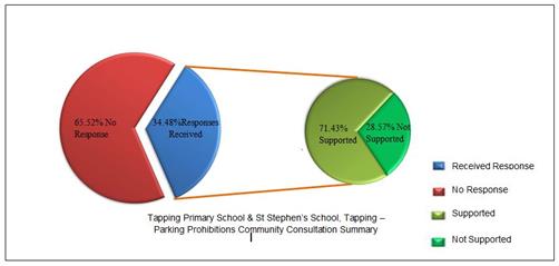
Comment
Following the community consultation, amendments have been made to the proposed parking prohibition plan to reflect the community survey. Refer to Attachment 10 for community response summary and respective Administration comments.
The recommended parking prohibitions are as shown on City of Wanneroo Drawing No 3042-1-1,3042-2-1, 3042-3-1, 3042-4-1, 3042-5-1 and 3042-6-1, (Refer Attachments 11, 12, 13, 14, 15 & 16).
It is noted that the proposed parking prohibitions will add an additional work commitment for the City's Parking Compliance Officers and as a consequence, will only be able to be enforced on an infrequent basis.
Statutory Compliance
The installation of parking prohibition signage will allow the enforcement of Part 4 Clause 38 of the City’s Parking and Facilities Local Law 2003 (as amended).
Strategic Implications
The proposal aligns with the following objective within the Strategic Community Plan 2013 – 2023:
“2 Society - Healthy, safe, vibrant and active communities.
2.3 Safe Communities - We feel safe at home and in our local area.”
Risk Management Considerations
Nil
Policy Implications
Nil
Financial Implications
The provision of parking prohibitions, incurs not only the initial cost of materials and installation of the signs, but also the ongoing cost of maintenance due to vandalism and graffiti. The estimated cost for materials and installation to implement this parking prohibition plan is $25,000. Project No PR-2657 – Parking Scheme Signage and Line Marking, for which $15,000 has been allocated in the 2015/2016 Capital Works Budget and the $15,000 funding allocated in the draft 2016/17 Capital Works Program. Due to a funding shortfall, it is proposed to seek additional funds as part of the mid-year Budget review to facilitate the implementation of these parking prohibitions later in the 2015/2016 financial year.
Voting Requirements
Simple Majority
That Council:-
1. APPROVES the installation parking prohibitions as shown City of Wanneroo Drawing No 3042-1-1,3042-2-1, 3042-3-1, 3042-4-1, 3042-5-1 and 3042-6-1, (Attachments 11, 12, 13, 14, 15 & 16);
2. ADVISES the petition organiser and residents of Council’s decision;
3. ADVISES Tapping Primary School and St Stephen’s School of the approved parking prohibitions and seek their support with advising their school communities, through the school newsletters, of the implications of these parking prohibitions; and
4. NOTES that the implementation of these parking prohibitions will occur later in 2015/2016 subject to allocation of additional funding in PR-2657 during the Mid-Year Budget Review.
Attachments:
|
1. |
Location Map; Tapping Primary School & St Stephen's School, Tapping |
15/431502 |
|
|
2. |
Drawing_3042-1-0_Tapping Primary School & St Stephen's School, Tapping- Parking Prohibitions |
15/431655 |
|
|
3. |
Drawing_3042-2-0_Tapping Primary School & St Stephen's School, Tapping- Parking Prohibitions |
15/431663 |
|
|
4. |
Drawing_3042-3-0_Tapping Primary School & St Stephen's School, Tapping- Parking Prohibitions |
15/431668 |
|
|
5. |
Drawing_3042-4-0_Tapping Primary School & St Stephen's School, Tapping- Parking Prohibitions |
15/431675 |
|
|
6. |
Drawing_3042-5-0_Tapping Primary School & St Stephen's School, Tapping- Parking Prohibitions |
15/431679 |
|
|
7. |
Drawing_3042-6-0_Tapping Primary School & St Stephen's School, Tapping- Parking Prohibitions |
15/431682 |
|
|
8. |
Simplified Drawing 3042 - 1A - 0 Tapping Primary School & St Stephens School Parking Prohibitions, Tapping |
15/170528 |
|
|
9. |
Consultation area map - Tapping Primary School & St Stephens School-Parking Prohibitions |
15/475723 |
|
|
10. |
Community Consultation Comments and Administration's Response |
15/484524 |
|
|
11. |
Amended Drawing 3042-1-1_Tapping Primary School & St Stephen's School, Tapping - Parking Prohibitions |
15/433526 |
Minuted |
|
12. |
Amended Drawing 3042-2-1_Tapping Primary School & St Stephen's School, Tapping-Parking Prohibitions |
15/433532 |
Minuted |
|
13. |
Amended Drawing 3042-3-1_ Tapping Primary School & St Stephens School, Tapping - Parking Prohibitions |
15/477816 |
Minuted |
|
14. |
Amended Drawing 3042-4-1_ Tapping Primary School & St Stephen's School, Tapping-Parking Prohibitions |
15/447139 |
Minuted |
|
15. |
Amended Drawing 3042-5-1_Tapping Primary School & St Stephen's School, Tapping - Parking Prohibitions |
15/433542 |
Minuted |
|
16. |
Amended Drawing 3042-6-1_ Tapping Promary School & St Stephen's School, Tapping-Parking Prohibitions |
15/433547 |
Minuted |
CITY OF WANNEROO Agenda OF Elected Members' Briefing Session 06 October, 2015 210
File Ref: 3120V03 – 15/452814
Responsible Officer: Director Assets
Disclosure of Interest: Nil
Attachments: 6
Issue
To consider the outcomes of community consultation for the opening of Marathon Loop onto Gnangara Road and to consider the reduction of the speed limit along Gnangara Road from 70km/h to 60km/h between Wanneroo Road and 250m west of Klaraborg Drive.
Background
Council at its meeting of 26 May 2015 considered a report (IN08-05/15 refers) investigating the possible opening of Marathon Loop (the eastern cul-de-sac end) onto Gnangara Road and resolved as follows;
“1. ENDORSES for community consultation purpose, the concept plan as shown in City of Wanneroo Drawing No 3128-1-0 (Attachment 2) with the following details:
a) opening the existing Marathon Loop (western end) intersection onto Gnangara Road as a Left-In/Left-Out Only intersection, and
b) opening of Marathon Loop (cul-de-sac end) onto Gnangara Road as a full intersection.
2. NOTES that a report will be presented to Council following the conclusion of the community feedback process.”
In accordance with the resolutions, community consultation has been undertaken and the outcomes are presented as part of this report.
In addition, Main Roads WA (MRWA) has approved a reduction of the speed limit along Gnangara Road between Wanneroo Road and 250m west of Klaraborg Drive. In order for this change to occur, formal endorsement is required from Council.
A location map of the subject site is shown as Attachment 1.
Detail
The recommended access arrangement onto Gnangara Road and the required intersection modifications are shown on City of Wanneroo Drawing No. 3128-1-0 (Refer Attachment 2).
In order to ensure that any additional road connection(s) onto Gnangara Road are done so with safety considered as a priority, a number of initiatives have also been actioned as follows.
Removal of Heavy Haulage Traffic from Gnangara Road between Wanneroo Road and Hartman Drive
Following a review of the heavy haulage road network, and prior to consultation with MRWA, the City wrote to MRWA on 24 August 2015 requesting that Gnangara Road, between Wanneroo Road and Rigali Way, be re-classified so that it no longer allows heavy haulage vehicles between 19.0m and 27.5m to traverse its length. MRWA has agreed to the City’s request and advised its support in September 2015 for the application of the re-classification.
Speed Limit Reduction – Wanneroo Road to 250m west of Klaraborg Drive
The City wrote to MRWA on 30 April 2015 requesting that Gnangara Road between Wanneroo Road and 250m west of Klaraborg Drive be considered for a speed limit reduction from the existing 70km/h posted speed limit. MRWA advised in May 2015 that a speed limit reduction has been approved to result in a posted speed limit of 60km/h for the abovementioned section. The approval has been granted in lieu of the significant traffic volumes and adjacent residential properties and the differing roadside development compared to east of Klaraborg Drive. The speed limit reduction requires formal endorsement from Council in order to be actioned by MRWA. As the supply, installation and maintenance of all road signage and linemarking is the responsibility of MRWA these works will be coordinated by MRWA within 4 – 6 weeks of the City advising MRWA of Council’s endorsement.
The speed limit reduction was requested by the City in response to MRWA’s advice that it did not support the at-grade connection of the proposed realignment of Gnangara Road into Whitfords Avenue/Wanneroo Road. It was anticipated that following the initial speed limit reduction to 60km/h, and together with the removal of the heavy haulage vehicles, that MRWA would consider a further reduction of the speed limit to 50km/h, however in recent discussions with the City, MRWA advised that while Gnangara Road continues to connect between Wanneroo Road and Hartman Drive, it will continue to be classified as a District Distributor Road and therefore it does not qualify for consideration of a further reduced speed limit of 50km/h, irrespective of the residential development adjacent to it.
Consultation
Consultation was undertaken in June 2015; 187 letters were sent to owners and occupiers of the 143 properties in the residential precinct to the north-east of Wanneroo Road and Gnangara Road. Refer Attachment 3 for location/consultation map. A three week community consultation survey gave residents the opportunity to respond via an online ‘survey monkey’ link or by returning a hard copy questionnaire by reply paid envelope. A copy of the survey letter (refer Attachment 4) and questionnaire (refer Attachment 5) are included in this report for reference.
The City received 28 responses (28%) from the 143 properties surveyed. 17 respondents (60%) were in favour and 11 opposed (40%) to the staged connections of Marathon Loop to Gnangara Road.
Of the 11 respondents that opposed the works, nine were from Marathon Loop properties between Owen Link and the proposed full opening (existing cul-de-sac) end of the road. These properties will be directly affected by the opening works and exposed to increased traffic along the street as a result.
Comment
A summary of comments made by respondents who opposed the opening of Marathon Loop onto Gnangara Road were as follows;
|
Comments |
Administrations Response |
|
Concerns regarding increased traffic volumes |
Traffic volumes along Marathon Loop are expected to increase between Owen Link and the eastern end of the road, which will still be very low in overall numbers and expected to be similar to Buffalo Avenue or less. While being access roads, Buffalo Avenue and Marathon Loop have the desirable capacity of carrying 3000 vehicles per day, the recorded traffic volume on Buffalo Avenue is only 673 vehicles per day.
As such, Administration considers the traffic volume increase on Marathon Loop will be minimal and the road will operate well within its capacity without any negative impact on adjacent properties. Administration also considers that the overall safety outcomes outweigh the inconvenience of higher traffic volumes. |
|
Concerns regarding increased traffic noise |
As the traffic is likely to be mainly local traffic, any increase in traffic noise is expected to be very low, however the overall safety outcomes outweigh the inconvenience of higher traffic volumes. |
|
Concerns regarding safety at the proposed intersection connections with Gnangara Road |
In relation to the Stage 1 of the concept proposal, a detailed analysis of opening of Marathon Loop western end onto Gnangara Road as a left-in/left-out intersection, has indicated that the intersection is able to operate safely at 50km/hr, or less, speed environment. With consideration of the ultimate scenario of having Gnangara Road realigned into Whitfords Avenue resulting in Gnangara Road between Wanneroo Road and Klaraborg Drive being cul-de-sac’d and reclassified as a local distributor road, the speed limit would then be able to be reduced to 50km/h and the Marathon Loop western end intersection with Gnangara Road would then be able to operate safely. As MRWA has only permitted a reduction of the speed limit to 60kmh, the City is at this stage unable to consider proceeding with allowing a left-out exit movement and is therefore only able to proceed with allowing left-in entry in place of the original left/in/left-out concept proposal. In relation to the Stage 2 of the concept proposal, being a full intersection at eastern Marathon Loop/Gnangara Road, it is noted that this intersection will be designed in accordance with applicable standards and to operate safely. |
|
Concerns regarding access from driveways as a result of increased traffic volumes |
Minor inconvenience may be experienced in the peak hours; however the increase in traffic is not expected to cause much of a delay for residents when entering/exiting their driveways. |
|
Concerns regarding restricted pavement width |
Sufficient road width is available to cater for the increased traffic flow. |
|
Concerns regarding street usage i.e. Constant thoroughfare |
While the movement of traffic along Marathon Loop is expected to increase it will provide a second safe full movement intersection for the precinct in addition to Buffalo Avenue. |
|
Safety to children outside homes |
As is the case with all residential access streets, all pedestrians need to be considerate of the road environment and take caution when crossing or walking on those streets. |
|
Homes values |
The City is unable to comment on any impact on values. |
Furthermore, by reviewing all comments made by residents, significant emphasis was placed on the following issues:
|
Comments |
Administrations Response |
|
Serious safety concerns when exiting onto Gnangara Road due to Heavy Haulage Vehicles |
MRWA has agreed to remove Gnangara Road between Wanneroo Road and Rigali Way from Heavy Haulage network. |
|
General concerns regarding the volume, size and noise generated by trucks along Gnangara Road adjacent to the residential precinct. |
MRWA has agreed to remove Gnangara Road between Wanneroo Road and Rigali Way from Heavy Haulage network. Additionally the speed limit on Gnangara Road in the immediate vicinity will also be reduced from 70km/hr to 60km/hr. |
|
The future problem to be faced as a result of recently approved subdivision development in the area which the City has approved without any additional access to the area. |
The road network has sufficient capacity to carry the new subdivisional traffic. |
|
The need for the future realigned construction of Gnangara Road into Whitfords Avenue and subsequent connection of Buffalo Avenue. |
The City agrees that the Gnangara Road realignment is necessary and is working to develop a solution with MRWA to provide an additional access for the residential precinct via Buffalo Avenue. The options being considered will undoubtedly have an impact on the overall movement of traffic within the area. As this is the case, the City is making every effort to ensure that an appropriate solution is identified and implemented as soon as possible. |
|
The need for an additional access north out of the area as an alternative to any connections on Gnangara Road |
See comment above. |
As the detailed review of the opening of the western end of Marathon Loop onto Gnangara Road has shown that the sightlines for the left-out movements are not adequate for 60km/h, it is recommended that only left-in entry be permitted. However, additional temporary infrastructure will be required to be installed to reduce the attractiveness of possible non-compliant exiting manoeuvres. The provision of the left-in entry at the western end of Marathon Loop will provide an alternate entry to the area which will provide some more direct connections to homes for traffic entering the estate. In addition, this access will also provide a more direct connection for Botev Lane, which operates under one-way flow from Marathon Loop to Buffalo Avenue. The left-in entry will provide a much more efficient and suitable connection between Gnangara Road and the garages of homes along Botev Lane and should also reduce issues of non-compliant entry into the laneway from Buffalo Avenue.
As the intersection at the western end of Marathon Loop is already constructed, it is considered that should the Gnangara Road realignment occur, that once the existing section of Gnangara Road between Wanneroo Road and Klaraborg Drive is reclassified to a local distributor road and that a further speed reduction will be able to be applied through MRWA to have Gnangara Road operate at 50km/h. As such the left-out movement at the western end of Marathon Loop can then be connected to Gnangara Road and utilised safely.
As a result of MRWA not yet agreeing to the proposed at-grade 4-way connection of Gnangara Road into Whitfords Avenue, the construction of any part of the Gnangara Road realigned section has now been delayed and a timeframe when it is likely to occur is not yet known. The City will, however, continue to work with MRWA in order to ensure that project can proceed as soon as practically possible.
With consideration of all the comments provided by the community, the percentage split of support to non-support, the detailed analysis of the proposed intersection configurations, and the advice received from Main Roads regarding the non-support of a 50km/h speed limit on Gnangara Road, Administration considers that the opening of Marathon Loop at its eastern end to be a full movement intersection proceed as a priority. The implementation of the full movement connection of Marathon Loop at the eastern end is considered to be the best solution in the interim, while the ultimate proposal to realign Gnangara Road into Whitfords Avenue is developed in consultation with MRWA.
The major concern of the community is coming out of the residential precinct from north of Gnangara Road which is expected to be resolved by the opening of the full intersection at the eastern end of Marathon Loop. While left-in access will be provided at the western end of Marathon Loop, it is not expected to resolve the community’s main concern of coming out of the precinct. As such, Administration believes both intersection works should take place as a single project and both the intersections are opened at the same time. This will also eliminate any potential noncompliance issues at western Marathon Loop/Gnangara Road intersection. Attachment 6 shows the amended concept drawing number 3128-1-1.
In order for the construction of the Marathon Loop connections to be facilitated, detailed design, service locations, funding and construction scheduling will need to be considered. The proposed intersection at Marathon Loop/Gnangara Road is not currently listed in the City’s approved Capital Works Program and that the City’s resources are already allocated to deliver approved projects. Administration considers that there is a need to postpone the delivery of an approved project from the 2015/2016 Capital Works Program to allow an immediate commencement of the design of the Marathon Loop/Gnangara Road intersections.
Administration has identified Project No PR-2788, Romeo Road - Design and Documentation, to be considered for postponement to create the funding and resource capacity. Project (PR-2788) is listed in the City’s Capital Works Program for 2015/2016 and the design work is currently scheduled to be undertaken in the second half of the financial year. The City proposed to undertake the design of Romeo Road ahead of any future extension of Mitchell Freeway to Romeo Road and as the State Government has not indicated a timeframe for the extension, the detailed design of Romeo Road can be delayed to 2016/17 financial year.
It is therefore proposed that $40,000 of the funds allocated for Project Number PR-2788 be reallocated to a new project for Marathon Loop/Gnangara Road intersections, leaving $20,000 in PR-2788 to undertake the initial survey and a preliminary design of Romeo Road with the detailed design to be scheduled for 2016/2017 subject to the approval of the 2016/2017 budget.
The proposed reallocation of $40,000 for the Marathon Loop/Gnangara Road intersections project is considered sufficient to undertake engineering survey, design and documentation, service locations and preliminary works prior to the commencement of substantial construction works.
Subject to Council’s decision, the design of the new intersection is likely to take up to six months as there will be a need to liaise with service authorities and accommodate any subsequent changes in the design. The project will also require approvals from MRWA and other service authorities such as Western Power and Water Corporation which could take a further two to three months, resulting in the construction works commencing around July 2016.
After the finalisation of the design and seeking relevant approvals, the project can then proceed to construction as a priority in 2016/17 financial year subject to the allocation of further funds in 2016/17 Capital Works Budget.
Subject to the outcome of the discussions with MRWA and the implementation of an option to realign Gnangara Road, the Marathon Loop connections may need to be modified to better coincide in accordance with Agreed Structure Plan for East Wanneroo Cell 6 (Darch/Madeley) – ASP 8.
Statutory Compliance
Nil
Strategic Implications
The proposal aligns with the following objective within the Strategic Community Plan 2013 – 2023:
“3 Economy - Progressive, connected communities that enable economic growth and employment.
3.3 Easy to Get Around - The community is well connected and accessible with an integrated transport approach for all.”
Risk Management Considerations
Nil
Policy Implications
Nil
Financial Implications
Subject to detailed design and outcome of investigation of the various services, the works are estimated to be in the order of $230,000.
As noted in the comments section of this report, no project exists in the 2015/2016 Capital Works Program. Therefore, for the design of these works to be progressed during the 2015/2106 financial year funds will need to be allocated by consideration of a budget variation as proposed earlier in the report.
Voting Requirements
Absolute Majority
Recommendation
That Council:-
1. NOTES the results of community consultation and ENDORSES the concept plan as shown of City of Wanneroo Drawing No 3128-1-1 for the purpose of preparing detailed design as follows:
a) Full movement connection of Marathon Loop at its eastern end with Gnangara Road
b) Left-in only connection of Marathon Loop at its western end with Gnangara Road;
2. Pursuant to Section 6.8(1)(b) of the Local Government Act 1995 APPROVES BY ABSOLUTE MAJORITY the expenditure of $40,000 for the design of Marathon Loop / Gnangara Road intersections;
3. APPROVES the following budget variation to fund the project for the design of Marathon Loop / Gnangara Road intersections during the 2015/2016 financial year;
|
Project No |
From |
To |
Description |
|
PR-2788 |
$40,000 |
|
Romeo Road, Carabooda – Design and Documentation |
|
PR-XXXX |
|
$40,000 |
Marathon Loop/Gnangara Road intersections |
4. LISTS $190,000 funding for the construction works for Marathon Loop / Gnangara Road intersections in 2016/17 Capital Works Budget;
5. NOTES that the proposed works as a result of Resolution 1 above will be undertaken as a single project instead of two separate stages;
6. NOTES that left-out connection of western end of Marathon Loop at its intersection with Gnangara Road is dependent on the further reduction of speed limit in Gnangara Road from Wanneroo Road to 250m west of Klaraborg Drive to 50km/h;
7. ENDORSES the speed limit reduction on Gnangara Road between Wanneroo Road and 250m west of Klaraborg Drive as approved by Main Roads WA from 70km/h to 60km/h;
8. NOTES the removal of the Heavy Haulage route along Gnangara Road between Wanneroo Road and Rigali Way as approved by Main Roads WA;
9. SUPPORTS the further reduction of the speed limit on Gnangara Road from Wanneroo Road to 250m west of Klaraborg Drive to 50km/h and REQUESTS Director Assets to write to Main Roads WA notifying of this request; and
10. ADVISES the residents of Council’s decision.
Attachments:
|
1. |
Marathon Loop Gnangara Road - Locality Map |
15/139271 |
|
|
2. |
Marathon Loop Gnangara Road - Concept Plan |
15/142098 |
|
|
3. |
15 173286 MarathonLp_GnangaraRd_CommunityConsultationMap |
15/475725 |
|
|
4. |
MarathonLp_GnangaraRd, Madeley - Letter to Residents |
15/454294 |
|
|
5. |
MarathonLp_GnangaraRd - Community Consultation Questionnaire |
15/454309 |
|
|
6. |
Marathon Loop |
15/489753 |
|
CITY OF WANNEROO Agenda OF Elected Members' Briefing Session 06 October, 2015 225
File Ref: 3125V02 – 15/468965
Responsible Officer: Director Assets
Disclosure of Interest: Nil
Attachments: 1
Issue
To consider a petition requesting the installation of speed humps on Greenfields Circle, Hocking.
Background
Petition PT03-06/15, signed by 11 residents, was received by Council at its meeting of 23 June 2015. The petition reads:
“We as a community have come together in favour of petitioning to our local council to install speed humps in our street. Proposal to Construct speed humps In Greenfield Circle, Hocking.
It is respectfully requested that the Council consider (the installation of speed humps for safety).The ratepayers and residents of Wanneroo shire, whose names, details and signatures are set out on the attached list support this proposal. A summary of reasons for the proposal is (We feel that the speed limit is rarely practiced when people access our street. We also have frequent times of people speeding excessively dangerously down our street. This is dangerous to the residents and children of the street as it happens during the daytime. We feel with the new area that is being developed at the end of our street, will only add to an increase of traffic. It has been reported to the police that a child crossing the road recently was nearly struck by a speeding vehicle.) ie many parents and children from the neighbourhood use this road to get to the nearby primary school and it is also one of the main access roads to the shopping centre. This proposal contains 100 percent in favour by every resident on this street.”
All the signatories are from the section of Greenfields Circle between Elliot Road and Kostas Close. Refer to Attachment 1 for a location plan of the subject area.
Detail
Greenfields Circle is a local access road in the City’s Functional Road Hierarchy and has been constructed with a 7.5m wide pavement in a 20m wide road reserve. With a closed loop Greenfields Circle begins and ends at intersections with Elliot Road.
Liveable Neighbourhoods, in listing the function and characteristics of this type of road gives the indicative traffic carrying capacity of an Access Street A with a 7.5m wide pavement as up to 3,000 vehicles per day. Currently, the road operates under the default ‘built-up area’ speed limit of 50km/hr.
The following traffic data for Greenfields Circle was obtained during December 2014.
Traffic data:
Definitions
AWT - average Weekday Traffic
vpd - vehicles per day
85th percentile speed – the speed at or below which 85% of vehicles are travelling. 85th percentile speed is a widely used design criteria to understand the speed behaviour of a road.
Greenfields Circle – South of Demitrios Court
AWT – 804 vpd
85%ile speed – 59 km/hr
Greenfields Circle – West of Sapling Way
AWT – 344 vpd
85%ile speed – 60 km/hr
Greenfields Circle – South of Woodlands Grove
AWT – 633 vpd
85%ile speed – 58 km/hr
WA Police crash data provided by Main Roads WA shows that there has been one reported property damage only accident on Greenfields Circle during the five years period between 2010 and 2014. That accident was recorded as ‘Out of Control’ which usually indicates poor driver behaviour.
Consultation
No public consultation was undertaken in the preparation of this report.
Comment
The City frequently receives requests from residents regarding speeding and ‘hooning’. Administration is of the view that police presence and enforcement remain the best means of controlling driver behaviour. It is Administration’s view that traffic management should be reserved to correct systemic problems in the road network where a large proportion of drivers are exceeding the speed limit and the risk of possible accidents and injury justifies the cost of the treatments. For this reason the City’s Traffic Management Investigation and Intervention Policy (TMIIP), which is used to determine the justification and priority of any traffic management works, uses a multi-criterion approach to derive a score rather than speed alone. The criteria considered when assessing a road are:
· Speed
· Traffic volumes
· Crash history
· Road design and topography
· Vulnerable road users - Pedestrians/Cyclists
The TMIIP requires a score of greater than 60 to qualify for traffic management treatments, while scores between 30 and 60 points warrant increased attention to law enforcement and driver education.
The assessment for Greenfields Circle, based on the December 2014 traffic data, achieved a score of 46 which indicates that the construction of traffic management treatments at this location cannot be justified ahead of other higher scoring projects that are yet to be funded.
The contention that large volumes of traffic are added due to new development at the end of this road is not supported by the traffic data which shows the current traffic levels on Greenfields Circle are well within the function and capacity of the road.
The issues of speeding and hooning are considered to be police issues. While the City is concerned for the safety of its residents, its authority and responsibility is limited to the safe construction and maintenance of its roads. Individual drivers have the responsibility to drive within the State road rules. If drivers choose to disregard those rules, the only organization with the authority to enforce compliance is the WA Police. In this instance, Administration considers that speed enforcement is the appropriate response to the minority of drivers travelling above the default urban speed limit of 50km/hr. Accordingly, the traffic data will be presented to WA Police.
In addition, Greenfields Circle will be added to the City's Speed Advisory Trailer driver education program which provides motorists visual information about their speed and creates speed awareness.
Statutory Compliance
Nil
Strategic Implications
The proposal aligns with the following objective within the Strategic Community Plan 2013 – 2023:
“2 Society - Healthy, safe, vibrant and active communities.
2.3 Safe Communities - We feel safe at home and in our local area.”
Risk Management Considerations
Nil
Policy Implications
The traffic safety issues relating to Greenfields Circle has been investigated as per the City’s Traffic Management Investigation and Implementation Policy.
Financial Implications
Nil
Voting Requirements
Simple Majority
Recommendation
That Council:-
1. DOES NOT SUPPORT the installation of speed humps on Greenfields Circle;
2. NOTES that the City’s speed Advisory Trailer will be placed on Greenfields Circle in the week starting on 19 October 2015 to increase awareness about default built up area speed limit of 50 km/hr; and
3. ADVISES the petition organiser of Council's decision.
Attachments:
|
1. |
Location Map: Greenfields Circle, Hocking |
15/468986 |
|
CITY OF WANNEROO Agenda OF Elected Members' Briefing Session 06 October, 2015 230
Other Matters
File Ref: 1806 – 15/474410
Responsible Officer: Director Assets
Disclosure of Interest: Nil
Attachments: 1
Issue
To consider the outcomes of the Shark Barrier Feasibility Study report.
Background
In recent years, shark sightings and attacks on swimmers, divers and surfers have increased along the Western Australian coast, including the Perth Metropolitan Region. Given the growing population and increased beach and water usage, a shark barrier would benefit the community in providing a safe swimming area with a reduced risk of shark attacks.
Recently, a number of WA Local Authorities have implemented and/or investigated the feasibility of shark barriers along their beaches including:
· City of Cockburn – Coogee Beach;
· Town of Cottesloe – Cottesloe Groyne;
· City of Joondalup – Sorrento Beach;
· City of Busselton – Old Dunsborough Beach; and
· City of Albany – Middleton Beach.
Council, at its meeting on 26 May 2015, considered a Motion on Notice from Mayor Tracey Roberts (MN01-05/15 refers) and resolved to:
“That Council REQUESTS Administration to investigate the feasibility of installation of a shark barrier at City’s beaches and report back to Council in December 2015.”
This report and attached Shark Barrier Feasibility Study Report (Feasibility Report) (refer Attachment 1) provides the necessary information to enable Council to make a decision regarding the next steps in the process; community engagement, applications for approvals/licenses, grant funding and tendering.
Detail
All details relating to the feasibility of installing a shark barrier within the City are provided in the Feasibility Report, which provides a brief overview of the following:
· Shark attack risks for Wanneroo;
· Available shark exclusion measures;
· Shark barrier considerations including:
o Benefits to the community;
o Interactions with other beach/water usage;
o Shark barrier suppliers;
o Approvals;
o Location and extent;
o Design and documentation; and
o Costs and funding opportunities.
Consultation
Preliminary discussions have been held with two potential shark barrier suppliers regarding the process and requirements for installation of a shark barrier along the WA coast. Both suppliers were involved in the recent successful shark barrier trial at Coogee Beach.
The City is also currently in discussion with Surf Life Saving WA regarding the location and extent of the proposed barrier and potential interaction with their operations. Initial discussions with the Quinns/Mindarie Surf Club were positive and correspondence will continue as the project progresses.
There has been no formal community engagement to date regarding installation of a shark barrier in the City.
Prior to appointment of a supplier, community engagement on the installation of a shark barrier is recommended.
Comment
The Feasibility Report has identified the required processes and considerations to allow for the installation of a shark barrier along the City’s coastline which will provide a safe swimming area for beach visitors, enhance the profile of the proposed beach location, increase the number of beach visitors and potentially boost clientele of local businesses.
Assessment of proximity to surf lifesaving patrols, safety, supporting infrastructure and coastal processes has identified the southern section of Quinns Beach as the preferred shark barrier location, subject to community engagement. Yanchep also remains as a possible location for a shark barrier due to the presence of surf life saving, however nearshore conditions are not as calm and coastal processes are not as well understood in this area compared with the southern section of Quinns Beach. Opportunities for additional shark barriers will also be investigated for areas of future coastal development, subject to the success of the proposed barrier at Quinns Beach.
Note that no entrapment of marine life or fouling by seagrass occurred at the Coogee Barrier over the trial period, confirming the benefits of the barrier-style shark exclusion measure over the more traditional shark nets. The recommended shark barrier system is also adaptable to changes in seabed level as a result of seasonal or storm induced erosion events.
However, the need for this is unlikely given that the recommended shark barrier location at Southern Quinns Beach is not currently in a state of erosion, based on the Quinns Beach Long Term Coastal Management Study – Stage 1 Report.
Further to the recommendation made in the feasibility study, the matter requires further consideration as:
· The City is also commissioning a feasibility study for an Ocean Pool at Quinns Beach, noting that the identified location (southern Quinns Beach) for the installation of a shark barrier is not likely to interfere with the potential ocean pool location(s) since the ocean pool location will be considered in conjunction with the existing and future coastal protection measures as a result of the Quinns Beach Long Term Coastal Management Study. Stage 1 of this study did not identify the need for any coastal protection structures in the southern Quinns Beach area; and
· No funding allocation has been made in the City’s budget for the installation of a shark barrier at Quinns Beach.
· No assessment has been made in regards to any additional facilities that may be required to support any future demand.
Subject to Council approval and positive community feedback from community consultation and allocation of appropriate funding, Administration will prepare a Request for Tender to include the planning/approvals, design, supply, installation and inspection/maintenance (for a period of 5 years) of a shark barrier at Southern Quinns Beach.
Statutory Compliance
The following departments will need to be informed and in some cases approval will need to be obtained prior to the installation of a shark barrier:
· Department of Transport;
· Department of Lands;
· Western Australian Planning Commission;
· Department of Aboriginal Affairs;
· Department of Parks and Wildlife;
· Department of Fisheries;
· Department of Environment Regulation; and
· Surf Life Saving WA.
Prior to liaising with and/or seeking approvals from the above departments, barrier design and location will need to be finalised. It is estimated that the approval process could take three to six months.
Strategic Implications
The proposal aligns with the following objective within the Strategic Community Plan 2013 – 2023:
“1 Environment - A Healthy and sustainable natural and built environment
1.1 Environmentally Friendly - You will be part of a community that has a balance of environmentally friendly development and conservation areas for future generations to enjoy”
Risk Management Considerations
There is no existing Strategic or Corporate Risk within the City’s existing risk registers which relates to the issue contained within this report, however risk management will be considered throughout the planning, design, installation and operational phases of the shark barrier project.
Risk assessment documentation will be requested from the shark barrier supplier with regards to safety in design and risk management during installation and operation.
Policy Implications
Nil
Financial Implications
Expected costs for the design and installation of a shark barrier are in the order of $300,000 depending on the exact location, length and the product, with annual inspection and maintenance costs in the order of $10,000 to $20,000. This cost is for a 300m (parallel to the coast) by 75m (perpendicular to the coast) barrier, similar to that installed at Coogee Beach.
Should the installation of a shark barrier be endorsed by Council, funds will need to be listed for Council’s consideration in the City’s 20 year Capital Works Program.
State Government funding opportunities may also be available for the installation of beach enclosures/shark barriers along the WA coastline and these will be pursued following Council approval to proceed.
That Council:
1. NOTES that Southern Quinns Beach is the preferred location for the installation of a shark barrier;
2. REQUESTS Administration to undertake further community consultation;
3. REQUESTS Administration to investigate all opportunities for grant funding and submit applications if appropriate;
4. LISTS $300,000 for the installation of a shark barrier at Southern Quinns Beach in the 20 year Capital Works Program under Foreshore Management;
5. REQUESTS Administration to consider the need for additional infrastructure as part of the proposed Quinns Foreshore Master Plan or beach safety measures as a result of the proposed shark barrier and likely increase in the number of visitors to Quinns Beach;
6. NOTES that the procurement process will involve a public tender inclusive of all approvals, design, supply, installation and inspection/maintenance of a shark barrier at Southern Quinns Beach; and
7. REQUESTS Administration to investigate additional shark barrier locations along the City’s coastline in areas of future coastal development.
Attachments:
|
1. |
Attachment 1 - SHARK BARRIER FEASIBILITY STUDY REPORT |
15/465100[v3] |
|
CITY OF WANNEROO Agenda OF Elected Members' Briefing Session 06 October, 2015 248
Community Development
File Ref: 5440 – 15/444779
Responsible Officer: Director Community & Place
Disclosure of Interest: Nil
Attachments: Nil
Previous Items: CD02-06/15 Agenda; CD02-06/15 Minutes
Update PT03-03/15 to install industrial fans at the Gumblossom Sports Hall
Issue
To consider Petition PT03-03/15 to install air-conditioning or industrial fans at Gumblossom Sports Hall.
Background
Petition PT03-03/15 was tabled to Council at its meeting held on 31 March 2015. The petition was submitted by a local resident who uses the hall on a regular basis as a part of the Prime Movers group. The petition sought to “install air conditioning or industrial fans at the Gumblossom Community Hall” on the basis that the hall is “stifling hot in the summer months.” It is important to note the petition states a preference for wall mounted fans on the basis that the hall is regularly used to capacity, meaning there is limited floor space for free stand fans.
At its meeting held on 23 June 2015, Council considered report CD02-06/15, which recommended the following:
“That Council APPROVES Administration to liaise with the petitioner to investigate the use of a large portable fan at Gumblossom Sports Hall or alternative venues with existing air conditioning for their activity.”
As a result of a procedural motion, Council moved the following:
“That the Motion be deferred for further information and a report presented to the next Council meeting.”
The amended report was then tabled for consideration at the Council Briefing held on 11 August 2015. As a result of concerns raised by Elected Members regarding consultation with the petitioner, the report was withdrawn.
Detail
As a result of the petition being received, Administration met with the Prime Movers group on 9 July 2015 to discuss the petition and potential solutions. This discussion also touched on possible alternative venues, noting that there were currently none but that the group would consider using the new Quinns Community Centre once it has been completed.
Subsequent to the Council Briefing held on 11 August 2015, the Manager Community Programs and Services contacted the petitioner to clarify the current situation and the outcomes being sought.
The petitioner re-confirmed the point that the petition was submitted by residents, who happened to be part of the Prime Movers group, not the Prime Movers group and that the free standing floor fans were not seen to be a suitable option, given that the hall is regularly used to capacity, leaving no room for the free standing floor fans.
As a consequence, the confirmed direction was as follows:
1. Investigate the installation of commercial grade wall mounted fans, as an immediate option; and
2. Seek capital budget funding in the 20 Year Capital Works program for the design and installation of suitable air conditioning and/or mechanical air extraction.
It should be noted that as a result of the initial receipt of the petition, Administration had sought a preliminary Order of Magnitude Cost for the installation of air conditioning/mechanical ventilation in the Sports Hall. This estimate has been put at $75,000, noting that detail investigation and design would be required to be undertaken to ascertain the most efficient option and to further refine the cost estimate.
The cost for the supply and installation of four wall mounted commercial grade fans (750mm diameter) has been put at $4,000, inclusive of project contingency.
Consultation
Administration met with a representative of the Prime Movers group on 9 July 2015 to discuss potential solutions and to review alternative venues. In addition to this, the Manager Community Programs and Services discussed the petition with the petitioner on 26 August 2015 and provided an update on 18 September 2015.
Comment
It should be noted that air conditioning for these type of facilities is problematic given their size and how they are used. The constant entry and exit of people for the hall means that doors are opening and closing on a constant basis which impacts on air cooling efficiency. This may require the installation of air locks to improve efficiency of an air conditioning system, adding to the cost. The outcomes of a detail design process will better understand if this is an issue (and identify any other issues) and provide a clearer understanding of cost.
Consideration also needs to be given to the impact of air conditioning on the activities undertaken in the hall. For example an air conditioning duct running down the centre of the roof space will reduce the floor to ceiling height of the hall, impacting on sports such as basketball and badminton. Air condition outlets on the side of the internal walls will impact the flight of shuttlecocks, therefore impact on the suitability of the hall for badminton.
Statutory Compliance
Nil
Strategic Implications
The proposal aligns with the following objective within the Strategic Community Plan 2013 – 2023:
“2 Society - Healthy, safe, vibrant and active communities.
2.1 Great Places and Quality Lifestyle - People from different cultures find Wanneroo an exciting place to live with quality facilities and services.”
Risk Management Considerations
There is no enterprise risks associated with this project.
Financial Implications
As noted, the cost for the supply and installation of four wall mounted commercial grade fans (750mm diameter) has been estimated at $4,000. It is intended that this amount be funded from PR-1015 Minor Building Works (Community Facilities), which currently has an available budget of $50,000.
A capital budget bid will be submitted for the design and installation of suitable mechanical air extraction and/or air conditioning as a part of the development of the 20 Year Capital Works program.
Voting Requirements
Simple Majority
That Council:
1. NOTES the expenditure of $4,000 from PR-1015 Minor Building Works (Community Buildings), for the provision of four 750mm wall mounted commercial fans in the Gumblossom Sports Hall, Quinns Rocks;
2. NOTES that the design and installation of mechanical air extraction and/or air condition for the Gumblossom Sports Hall, Quinns Rocks will be listed for consideration as a part of the 20 Year Capital Works Program development; and
3. AUTHORISES the Director Community & Place to advise the petitioners of the outcome.
Attachments: Nil
CITY OF WANNEROO Agenda OF Elected Members' Briefing Session 06 October, 2015 251
File Ref: 13797 – 15/463298
Responsible Officer: Director Community & Place
Disclosure of Interest: Nil
Attachments: 2
Issue
To consider the proposed concept plan for the development of Rendell Park, Koondoola.
Background
Rendell Park (the Park) is located on Rendell Way Koondoola and is an existing passive park of approximately 1.5 hectares in size. The Park, which backs on to Koondoola Open Space “A” Reserve, is classified as a dry park and currently has a combination unit and swing set as the only amenities on site.
Other existing public open space within the walkable catchment of the Park (400m to 800m, 5 minute to 10 minute walk) includes:
|
Park |
Location |
Use |
|
Koondoola Park |
90 Koondoola Avenue, Koondoola |
Active Reserve (AFL and Cricket), cricket nets and tennis courts. Community Centre proposed opening November 2015 |
|
Butterworth Park |
41 Butterworth Avenue, Koondoola |
Active Reserve (soccer), change room block, play combination unit, fitness equipment, 2 full size basketball courts with lighting. |
|
Shelvock Park |
17 Shelvock Crescent |
Active Reserve (Soccer) Playground, combination unit, swing set and Amenities buildings |
Detail
The initial draft concept plan for the development of the Park is included within (Attachment 1). The plan provides for the following elements:
|
Elements |
Description |
|
Concrete Bike/Scooter Track |
Bike/scooter path which is marked with the road markings to allow children to gain an understanding of road rules |
|
Play Area 1 |
Consultation to determine preference between Combination Unit or Rope Play |
|
Play Area 2 |
Consultation to determine preference between Carousel, Basket Swing, Spinner |
|
Bin |
Standard City of Wanneroo green wheelie bin |
|
Picnic Table |
Standard City of Wanneroo picnic table |
|
Sand softball |
Sand pit with installed measuring themed play equipment |
|
Timer Poles |
Standard City of Wanneroo Timber Pole installation specifications to create informal kick about space |
Given that there are three parks within a 1km radius with conventional playground equipment, the design philosophy underpinning the concept for the Park has chosen to focus on the development of a space that enhances children’s road wise knowledge.
A number of seating areas have been included to encourage intergenerational interaction and supervision of activities, in particular those involving young children. The concept also allows for participation in activities in different areas of the Park, providing flexibility of use.
Safety is provided by developing the central area only, which is completely open to view from the neighbourhood, and also by an enclosing path to the integrated play area. The concept has evolved within the existing clear area, therefore no trees are being removed.
The draft concept plan incorporates water-wise design principles by using coloured concrete and stabilised crushed limestone paths, additional native tree planting, while also maintaining a large area of unirrigated turf. The design of the park has taken into consideration existing parks within the surrounding area, noting the availability of both active, passive pursuits, irrigated and un-irrigated parks within the immediate area.
The draft concept plan allows for the development of the park in a single stage, within the current budget of $167,000 in the 2015/16 financial year. The proposed programming of works will see construction commence in April 2016 and conclude in June 2016.
Consultation
The community consultation period was conducted between 10 August and 4 September 2015 and included the following consultation strategy, as endorsed by the City’s Community Engagement Advisor:
· Distribution of the draft concept plan and public comment forms to residents and landowners within a 400 meter radius of Rendell Park;
· On site community consultation held on 26 August 2015 to allow interested members of the public to view and discuss the draft concept plan with the relevant City of Wanneroo staff members and;
· Inclusion of the concept plan and comment form on the City's web site under the 'Your Say" section.
· The draft concept plan in Attachment 1 was the basis of the consultation process.
Administration received a total of 24 comment forms from the 220 mailed out to residents; a response rate of 10.9%. The comment form requested residents to consider the proposed play features and then nominate a preference for the particular play area.
There were 22 responses that supported the proposed concept plan and only two (2) submissions that did not want the Park to be developed.
The respondents who didn’t support the plan felt that the funds proposed for upgrading the park would be of more value upgrading other amenities in the suburb. For the respondents who were in favour of the proposed concept, many comments focused on irrigated area’s and providing justification for the preference their of play equipment installation.
Comments include:
· Installation for Irrigation (requested by 2 respondents);
· Installation of a BBQ (requested by 2 respondents);
· The Park will need to be maintain once the upgrade is complete (requested by 2 respondents); and
· Consideration for tennis courts (requested by 2 respondents).
In terms of the optional items provided in relation to play areas 1 and 2, the outcome of the consultation process was:
· Play area 1 – preference for the combination unit.
· Play area 2 – equal preference for the spinner and basket swing. Given there is a basket swing currently provided at Butterworth Park, Administration will include the spinner equipment in the final Rendell Park concept.
As a result, the final concept plan will include the combination unit and the spinner play equipment.
For a summary of the community consultation results, refer to (Attachment 2).
Comment
In considering the additional items listed above, the following Administration advice is provided:
Installation of Irrigation
In response to the respondents who did not support the draft concept plan and citied irrigation as the number 1 priority, it should be made clear that irrigating the entire park was not considered in the concept design for the Park. This was due to cost, limited ground water availability for irrigation and the availability of irrigated turfed areas within the walkable catchment area.
Park Maintenance
Once the upgrade is completed, Rendell Park will be serviced as a Passive Park Unirrigated. The service level for this classification includes mowing four times a year, along with regular cleaning and maintenance.
Installation of a Barbeque (BBQ)
The cost of providing a BBQ as a part of the development of the Park is estimated to be in the order of $37,000 (minus ongoing maintenance costs), which includes the provision of power to the site. This item has not been considered within the draft concept plan due to the cost implications of the proposal on the project and that the installation of a BBQ is considered an over provision for a neighbourhood park development as outlined in the Local Planning Policy 4.3 Public Open Spaces, Schedule 8, Minimum Development Requirements.
Consideration of tennis courts
While the contours existing on site are not conducive for the installation of tennis courts, this item has not been considered within the draft concept plan due to the cost implications of the proposal on the project and on the basis that there are tennis courts available for use (at no cost) at Koondoola Park. It should be noted that these have been recently re-surfaced.
In concluding the consultation phase of the Rendell Park concept plan, Administration confirm the amenities to be installed at the Park will be as follows;
· Concrete Bike/Scooter Track;
· Combination Unit;
· Spinner;
· Bin;
· Picnic table;
· Sand softball; and
· Timber poles.
Statutory Compliance
Nil
Strategic Implications
The proposal aligns with the following objective within the Strategic Community Plan 2013 – 2023:
“2 Society - Healthy, safe, vibrant and active communities.
2.2 Healthy and Active People - We get active in our local area and we have many opportunities to experience a healthy lifestyle.”
Risk Management Considerations
There is no envisaged enterprise risks associated with the implementation of the project. Project risks will be identified and managed using the City’s Project Management Framework.
Policy Implications
The City's Local Planning Policy 4.3 Public Open Spaces was used as the guiding framework for the development of the draft concept plan.
Financial Implications
An allocation of $167,000 is listed in the Capital Works Budget under PR-2675 for the development of Rendell Park. The estimated cost for implementing the final concept plan is in the order of $166,951.25 inclusive of contingencies, design and project management fees and inflation.
Voting Requirements
Simple Majority
That Council:-
1. ENDORSES the Rendell Park final concept plan as shown in Attachment 1 of this report;
2. NOTES that based on the current proposed project schedule, construction is due to commence in April 2016 and will be concluded in June 2016; and
3. RECOGNISES and THANKS the community for its involvement in the community consultation component of the project.
Attachments:
|
1. |
Rendell Park Proposed Concept Plan |
15/232516 |
|
|
2. |
Rendell Park Consultation Results |
15/471884 |
|
CITY OF WANNEROO Agenda OF Elected Members' Briefing Session 06 October, 2015 258
3.19 PT01-09/15 - Request for Support for Dashndogs Academy to Provide Dog Training Services in Yanchep
File Ref: 14553V03 – 15/475127
Responsible Officer: Director Community & Place
Disclosure of Interest: Nil
Attachments: 1
Issue
To consider the petition PT01-09/15 requesting support for Dash n Dogs Academy to provide dog training services in Yanchep
Background
Petition PT01-09/15 comprises of 145 signatures and was presented to Council at its meeting held on 15 September 2015. The petition provided the following background information and requested action:
|
Petition Summary and background |
Dashndogs academy is a community dog training group in Yanchep providing owners with the service of assisting them in training and managing antisocial behaviour in their dogs . Also providing owners with socialisation classes for their new puppies ensuring they get a good start and assistance and support to Rescue dogs and their foster carers of dogs needing rehoming. The training group has become a supportive network for dog owners in the community and a valuable resource to owners |
|
|
Action Petitioned for: |
The academy is asking for this service to be supported by the cow by way of exclusion of ground booking fee charges or an agreed minimal fee to ensure it remains a viable service to the community. Considering there are no facilities on the ground including toilets, water, parking or other upkeep specific to our needs of operation. |
|
It should be noted that Administration recently made contact with the owner of the Dash n Dogs Academy (the Academy) in respect to the payment of facility hire fees for the use of Wilkie Park (the Park). Previously the Academy had been using the Park without a booking and therefore without payment of the appropriate hire fee.
The Park is an irrigated passive park of 6998m2, located on the corner of Wilkie Avenue and Yanchep Beach Road, Yanchep (Attachment 1). The public amenity on Wilkie Park includes:
· Playground
· Basketball pad
· Bench Seat
· Turf
Detail
The initial advice provided by Administration to the owner of the Academy was that a facility hire fee of $60 per hour was the applicable fee for the use of the Park, on the basis that the Academy is operated as a business.
Subsequent to this advice, and as a result of concerns raised by the Academy owner and the community, the Manager Community Programs and Services contacted the owner on 8 September 2015 to discuss the situation further. Based on the information provided as a result of this conversation, a revised fee of $65 per person per annum (equivalent to $1.25 per participant) was suggested being the current adopted community fee for dog obedience classes.
The revised fee was offered on the basis of advice provided by the Academy owner that, while the Academy was operated as a registered business, the services offered were done on a minimal profit basis and quite often at no charge.
In addition to this, Administration also advised that an alternative method of payment could be considered to take into consideration the fluctuating class numbers which are typically experienced by the Academy. It was agreed that this would include paying the fee on a quarterly basis in arrears, based on an average number of participants per class over the preceding quarter.
At the time of writing this report, the Manager Community Programs and Services was working with the Academy owner to finalise the booking and booking fee on this basis.
In respect to the concerns raised over available facilities, it should be noted that the facilities currently provided at the Park are consistent with its designation as a local park. Should the Academy require additional facilities, then Administration is more than willing to work with the Academy to find a more suitable park in the local area.
Consultation
As noted above, the Manager Community Programs and Services is currently working with the owner of the Academy to finalise a facility hire agreement based on the current adopted community facility hire rate of $65 per person per annum.
Comment
In Administration’s discussion with the Academy owner, the focus has been on the agreement of a reduced hire fee for the use of Wilkie Park rather than an “exclusion” of fees, as identified within the petition. This is on the basis that the payment of a minimal fee is considered appropriate and also on the basis that discussions with the Academy owner on this basis have been positive, with every indication being that the payment of a fee based on the community rate is acceptable.
Statutory Compliance
Nil
Strategic Implications
The proposal aligns with the following objective within the Strategic Community Plan 2013 – 2023:
“2 Society - Healthy, safe, vibrant and active communities.
2.1 Great Places and Quality Lifestyle - People from different cultures find Wanneroo an exciting place to live with quality facilities and services.”
Risk Management Considerations
There are no envisaged enterprise risks associated with the use of Wilkie Park by the Academy.
Policy Implications
Nil
Financial Implications
As noted earlier, the commercial rate for this type of activity is $60/hour, while the current community rate for Dog Obedience training is $65/person per annum.
Voting Requirements
Simple Majority
That Council:-
1. NOTES the receipt of Petition PT01-09/15, seeking consideration of a revised facility hire fee for the use of Wilkie Park by the Dash n Dogs Academy;
2. APPROVES Administration intended approach of charging a fee for the use of Wilkie Park by the Dash n Dogs Academy based on the current adopted community facility hire fee for dog obedience classes of $65 per person per annum (equivalent to $1.25 per participant) on the basis that the Dash n Dogs Academy operates on a minimal profit basis; and
3. AUTHORISES the Director Community & Place to advise the petitioners of the outcome.
Attachments:
|
1. |
Wilkie Park Yanchep - Location Plan |
15/477125 |
|
CITY OF WANNEROO Agenda OF Elected Members' Briefing Session 06 October, 2015 262
Other Matters
File Ref: 2883 – 15/455898
Responsible Officer: Director Community & Place
Disclosure of Interest: Nil
Attachments: 1
Issue
To consider an amendment to Delegation 7.9 Prohibited Burning Times as detailed in the City’s Delegated Authority Register, to align with current legislation.
Background
The Bush Fires Act 1954 (the Act) provides for the following delegation:-
“Section 17.(10) A local government may by resolution delegate to its Mayor, or President, and its Chief Bush Fire Control Officer, jointly its powers and duties under subsections (7) and (8).”
Section (7) and (8) refer:-
“(7) Subject to subsection (7B), in any year in which a local government considers that seasonal conditions warrant a variation of the prohibited burning times in its district the local government may, after consultation with an authorised CALM Act officer if forest land is situated in the district, vary the prohibited burning times in respect of that year in the district or a part of the district by —
(a) shortening, extending, suspending or re-imposing a period of prohibited burning times; or
(b) imposing a further period of prohibited burning times.
(7B) A variation of prohibited burning times shall not be made under subsection (7) if that variation would have the effect of shortening or suspending those prohibited burning times by, or for, more than 14 successive days.
(8) Where, under subsection (7), a local government makes a variation to the prohibited burning times in respect of its district or a part of its district the following provisions shall apply —
(a) the local government —
(i) shall, by the quickest means available to it and not later than 2 days before the first day affected by the variation, give notice of the variation to any local government whose district adjoins that district;
(ii) shall, by the quickest means available to it, give particulars of the variation to the FES Commissioner and to any Government department or instrumentality which has land in that district under its care, control and management and which has requested the local government to notify it of all variations made from time to time by the local government under this section or section 18;
(iii) shall, as soon as is practicable, publish particulars of the variation in that district;
(b) the Minister, on the recommendation of the FES Commissioner, may give notice in writing to the local government directing it —
(i) to rescind the variation; or
(ii) to modify the variation in such manner as is specified in the notice;
(c) on receipt of a notice given under paragraph (b) the local government shall forthwith —
(i) rescind or modify the variation as directed in the notice; and
(ii) publish in that district notice of the rescission or particulars of the modification, as the case may require.”
Detail
Subsequent to the annual review of the City’s Delegated Authority Register and its adoption on 23 June 2015 Administration undertook a further review of the CEO’s sub-delegations under Section 5.44 of the Local Government Act 1995. During this review it was noted that the instrument of delegation under section 17 (10) of the Bush Fires Act 1954 for the variation of prohibited burning times was non-compliant with legislation.
The instrument of delegation has been amended as shown in Attachment 1 to comply with legislation and to clarify the function delegated. It is further suggested that the reference to the name of the delegation be amended to read – “Variation of Prohibited Burning times”.
Consultation
Consultation has been undertaken with the Executive Manager Governance and Legal as well as the City’s Governance unit to ensure the delegation complies with current legislation.
Additionally advice was sought from McLeods Barristers and Solicitors to ensure that the delegation to the Mayor was not inconsistent with the functions of the Mayor as set out in s2.8 of the Local Government Act 1995.
Comment
It is important for Council to note that delegating a power does not transfer that power to the delegate, it merely replicates it and Council retains the ability to exercise any power or duty delegated to the CEO. (s.59 Interpretation Act 1984).
The essential elements of a Council delegation are the correct and accurate identification of the:
· power or duty to be delegated;
· office to whom or which the power or duty is to be delegated;
· circumstances in which the power or duty can be exercised or discharged; and
· conditions on the exercise of the power or duty.
The proposed amendments to the delegation will ensure that the details are correct and accurate.
A Management Procedure will be developed to ensure that the exercise of the delegation by the Chief Bush Fire Control Officer and the Mayor is undertaken in accordance with the requirements of the Act.
Statutory Compliance
The amended delegation accurately reflects the requirements of Section 17(10) of the Bush Fires Act.
Strategic Implications
The proposal aligns with the following objective within the Strategic Community Plan 2013 – 2023:
“4 Civic Leadership - Working with others to ensure the best use of our resources.
4.3 A Strong and Progressive Organisation - You will recognise the hard work and professionalism delivered by your council through your interactions and how our community is developing.”
Risk Management Considerations
There are no existing Strategic or Corporate Risk within the City’s existing risk registers which relate to the issue contained within this report however the adoption of the amended delegation will strengthen the City’s legislative compliance management systems.
Policy Implications
Nil
Financial Implications
Nil
Voting Requirements
Absolute Majority
That Council ADOPT BY ABSOLUTE MAJORITY the amended delegation of authority 7.9 Variation of Prohibited Burning Times as shown at Attachment 1.
Attachments:
|
1. |
Amended Delegation 7.9 Variation to Prohibited Buring Times |
15/428208 |
Minuted |
CITY OF WANNEROO Agenda OF Elected Members' Briefing Session 06 October, 2015 266
File Ref: 1465 – 15/464030
Responsible Officer: Director Community & Place
Disclosure of Interest: Nil
Attachments: 5
Previous Items: CD01-04/15 Agenda; CD01-04/15 Minutes
South Ward Active Reserve Master Planning Process Outcomes
Issue
To consider the outcomes of the Central Ward and Coastal Ward (to be incorporated in the new North Coast Ward) Active Reserve Master Planning process.
Background
The Central Ward and Coastal Ward (to be the North Coast Ward post the 2015 Local Government Elections) Active Reserve Master Planning (ARMP) process was listed as a part of the 2014/15 Capital Works Budget (PR-2957 and PR-2928). This was in addition to the South Ward Active Reserve Master Plan process, which was undertaken by the South Ward Community Reference and Sporting User Group in the 2014/15 financial year and reported to Council at its meeting held on 28 April 2015 (CD01-04/15).
The purpose of the ARMP process for the Central and Coastal (North Coast) Wards was as follows:
· Guide the development or re-development (upgrade) of infrastructure;
· Identify current/future uses, levels of use and barriers to use;
· Maximise the flexibility and use of each reserve;
· Provide evidence based need and feasibility to support the proposed upgrades;
· Identify agreed project priorities; and
· Inform the City’s 10 Year Capital Works Budget.
The scope of the ARMP processes was as follows:
|
Key Phases |
Key Steps |
|
A. Existing Facility Analysis (SWOT)
|
Audit of catchment population and demographics Audit of sporting club and Association memberships Current usage levels Infrastructure condition Land ownership Sports field dimension Operating costs |
|
Key Phases |
Key Steps |
|
B. Future Impact Report (SWOT)
|
Water allocation Environmental approvals Planning approvals Impacting policies Funding opportunities |
|
C. Concept Plan with Costings |
Concept Plan development Cost Report |
|
D. Recommendations |
Development of Master Plan Report |
|
Exclusions |
Detailed design and construction |
The methodology undertaken within the ARMP process was as follows:
1. Individual Park Analysis
2. Community Consultation (phase 1)
3. Develop recommendations
4. Draft Master Plan Designs
5. Cost Estimates
6. Prioritise
7. Community Consultation (phase 2)
8. Report back to Council
Detail
In undertaking the ARMP process, the outcomes sought were as follows:
· Identify agreed base principles/assumptions for each of the Active Reserves;
· Identify an agreed understanding of future usage for each of the Active Reserves;
· Identification of required infrastructure upgrades, listed in an indicative priority order; and
· An agreed preliminary General Arrangement Concept for each Active Reserve.
The agreed base principles/assumptions for each of the Active Reserves included in the ARMP process for each ward are as follows:
· The Park (Active Reserve) will continue to be used for both organised sport and passive recreational purposes, consistent with its designation as a Neighbourhood Park;
· The Park (Active Reserve) will continue to accommodate use by both junior and senior sports;
· Facility hire will continue to be managed by the City through its existing facility booking system and guided by the City's Facility Hire policy; and
· The Active Reserve (playing field) will continue to be of a multi-purpose nature primarily (but not exclusively) providing for AFL, cricket, rectangular field sports (soccer and rugby) and diamond sports.
It should be noted that the above outcomes and agreed base principles/assumptions are consistent with those identified as a part of the South Ward Active Reserve Master Plan process.
A summary of the outcomes from the Central Ward ARMP process and Coastal Ward (North Coast) ARMP process has been included in (Attachment 1 and Attachment 2), respectively.
As a result of the ARMP process, a total of 54 individual projects at an approximate cost of $8.65M have been identified in the Central Ward and a total of 59 individual projects at a cost of $11.1M identified for the Coastal Ward
A summary of outcomes based on infrastructure type has been included in (Attachment 3 and Attachment 4) for the Central and Coastal (North Coast) Wards respectively. The range of projects is quite diverse, as outlined within the table below:
|
Central Ward |
Coastal (North Coast) Ward |
|
Floodlighting (4) |
Floodlighting (7) |
|
Drink Fountains (4) |
New/additional storage (7) |
|
Irrigation upgrades (3) |
Car park – new (4) |
|
New car parking (3) |
Turf upgrades (3) |
|
New/additional storage (3) |
Drink fountains (3) |
|
Refurbishment of toilets/changerooms(3) |
Bench seating (3) |
The resulting draft Master Plans for each of the identified Active Reserves within each of the Wards has been provided to each Elected Member under separate cover due to the number of respective Master Plans and the level of detail contained within each.
In terms of meeting the scope requirements for the master planning process, Administration has been successful in achieving all aspects of the scope with the exception of future use/demand analysis, for reasons outlined in the following section.
Prioritisation of Identified Individual Infrastructure Projects
Project prioritisation for the outcomes of the Central Ward ARMP process has been undertaken using the matrix template and criteria as included within (Attachment 5). The matrix and criteria is based on existing matrices used in the prioritisation of the City's Dry Parks, Shade Structures and Playground upgrades.
The matrix template has been applied to each individual Active Reserve identified within the ARMP process, capturing each of the infrastructure upgrades identified by the Reference Group.
The matrix includes seven criteria in total (A1 to A7). A brief outline of each of the matrix criteria is provided below:
|
A1 - Current level of the reserve on average per week. |
|
· Captures the current level of use of the Active Reserve, assigning a rating of 5 to the highest level of use and a rating of 1 to the lowest level of use. |
|
A2 - Would additional infrastructure on this reserve increase the current level of use? |
|
· Captures the impact of the infrastructure upgrade on the future use of the Active Reserve, assigning a rating of 3 for yes and 1 for no. |
|
A3 - SEIFA Index (Advantage & Disadvantage - ID Forecast). |
|
· The Social Economic Indexes for Areas (SEIFA Index) for Advantage and Disadvantage is taken from the City's ID Forecast modelling, which in turn is based on ABS 2011 data. The index represents relative levels of advantage and disadvantage for each suburb within the City based on the factors of income, education attainment, unemployment and occupation. |
|
· The average score on the index is 1,000 (based on Australian average – population weighted); therefore a score > 1,000 have a relatively lower level of disadvantage, while scores of < 1,000 have a relatively higher level of relative disadvantage. · On this basis a rating of 5 has been given to areas with the lowest score (therefore higher level of disadvantage) and a rating of 1 to areas with the highest score (therefore lower level of disadvantage). |
|
A4 - Prioritisation Rating By Administration |
|
· Captures the existing prioritisation given by Administration for each individual infrastructure upgrade identified for each Active Reserve. · A rating of 5 has been given to the highest priority and a rating of 1 has been given to the lowest priority. |
|
A5 - Supporting amenities on site. |
|
· Seeks to captures the impact a particular infrastructure upgrade has on the Active Reserve and its existing amenity. · A high rating will be given to infrastructure upgrades that complement existing amenities and therefore further enhances provision on that site, where as a lower rating will be provided to infrastructure upgrades that do not. |
|
A6 – Local Planning Policy 4.3 – Public Open Space Development Amenity Assessment |
|
· Captures the assessment of the proposed infrastructure upgrade against the policy, providing a rating of 3 for items which are identified as minimum development requirements and a rating of 1 for items which are identified as overprovision within the policy. |
|
A7 - Precinct consideration |
|
· The criterion seeks to reflect the role of the Active Reserve within its precinct (catchment based on suburb or suburbs). If the role of the Active Reserve, or an individual infrastructure upgrade in the Active Reserve, is significant within the precinct, then a higher rating will be applied, compared to an infrastructure upgrade that is of a lower level of significance. |
A summary of the matrix scores for all individual infrastructure upgrades identified within Central Ward and Coastal (North Coast) Ward has been provided to Elected Members under separate cover given the size of the document. This prioritisation was used as the basis for the development of the 2015/16 Capital Works Budget.
The current forward Capital Works Budget prioritisation, reflecting the outcomes of the Elected Member budget workshops for the 2015/16 financial year, has also been provided under separate cover.
Finalisation of Master Planning Process
It should also be noted that finalising the prioritisation process has been impacted by the lack of advice being provided by the 19 State Sporting Associations who were contacted by Administration requesting the provision of the following key data:
· Relevant strategic planning documentation in relation to the growth of the respective sport and future facility requirements;
· 2014 membership numbers for clubs that are affiliated with the respective Associations and which are based within the City of Wanneroo; and
· Projected membership numbers for those City of Wanneroo based clubs projected forward to 2019 and 2024.
This work is continuing, with Administration having already met with West Australian Football Commission, Baseball WA, Football West and Hockey WA and schedule to meet with Rugby WA, WA Athletics, the West Australian Cricket Association (WACA) and hopefully Tennis West by the end of October 2015. In addition to this, Administration has sought information from the following State Sporting Associations without success:
· West Australian Marathon Club;
· Gridiron West;
· Lacrosse WA Inc;
· Western Australian Rugby League Ltd;
· Softball Western Australia Inc;
· Tee-Ball Association of WA;
· Touch Football WA;
· Rollersports Association of WA Inc;
· Federation Sport Bocce of WA Inc; and
· Archery Western Australia.
It should also be noted that information has been provided by Netball WA.
It is however, acknowledged that the finalisation of the demand analysis will not be completed in time for presentation to Council at its meeting in December 2015 (as advised in report CD01-04/15). It is envisaged that this will now occur in early 2016. Any changes to the prioritisation of the existing infrastructure upgrades identified as a part of the ARMP process resulting from the demand analysis will be included in the 2016/17 budget process.
It should be noted that this report (along with CD01-04/15 relating to the South Ward Active Reserve Master Plan process outcomes) will now replace the interim City of Wanneroo Active Reserve Master Plan report, as advised in CD01-04/15, noting that the complete final report will be presented to Council early in 2016.
Consultation
Consultation has occurred as follows:
· Phase 1 - City wide on-line survey of existing users of the City's Active Reserves in July and August 2014;
· Phase 2 – Workshop 1: Facility Concept Development – held on 15 and 22 September 2014 for the Coastal and Central Wards respectively.
· Phase 2 - Workshop 2: Concept Design Presentation for consultation – held on 22 April 2015 and 28 May 2015 for the Coastal and Central Wards respectively.
· Phase 3 - presentation of the Ward Active Reserves Master Plan Interim Reports to Council. The interim report for the South Ward Active Reserve Master Plan was presented to Council on 28 April 2015 (CD01-04/15) and on 13 October 2015 for the Central and Coastal Wards.
· Phase 4 – report final draft City of Wanneroo Active Reserve Master Plan Report to Council seeking approval for release for public comment (early 2016);
· Phase 5 – report to Council seeking final endorsement of the draft City of Wanneroo Active Reserve Master plan Report post public comment period (early 2016)
It should be noted that each individual Active Reserve Master Plan and related infrastructure upgrade project will become a separate project within the City's 20 Year Capital Works Program and as such will be subject to further consultation with user groups and residents.
Comment
By way of summary, the purpose of the ARMP process for the Central and Coastal Ward (North Coast) has been to:
· Guide the development or re-development (upgrade) of infrastructure;
· Identify current/future uses, levels of use and barriers to use;
· Maximise the flexibility and use of each reserve;
· Provide evidence based need and feasibility to support the proposed upgrades;
· Identify agreed project priorities; and
· Inform the City’s 10 Year Capital Works Budget.
As a result, the intention of the ARMP process for both the Central and Coastal (North Coast) Wards has been to identify the specific infrastructure projects required at each of the Active Reserves within the respective Wards to meet the needs of the community both now and into the future. The intention has also been to provide an evidence base which assists Council in their decision making process in regards to the funding and timing of projects.
To a large degree the purpose of the Master Planning process has been achieved, however more work is required to be undertaken (and is progressing) in the area of demand forecasting and analysis to understand in greater detail when additional infrastructure provision is required and to enable any changes in future uses to be identified and accommodated as a part of the process. This work will require Administration to work directly with the relevant State Sporting Associations and local clubs.
Statutory Compliance
Nil.
Strategic Implications
The proposal aligns with the following objective within the Strategic Community Plan 2013 – 2023:
“2 Society - Healthy, safe, vibrant and active communities.
2.2 Healthy and Active People - We get active in our local area and we have many opportunities to experience a healthy lifestyle.”
Risk Management Considerations
Nil
Policy Implications
The Central Ward and Coastal Ward (North Coast) ARMP processes have considered the City's Local Planning 4.3 Public Open Space Policy, City's Floodlighting Policy and the City's Facility Hire and Use Policy. Implementation of the outcomes of the process will also need to consider the City’s Community Engagement Policy.
Financial Implications
As identified earlier in this report the outcomes of the Central Ward and Coastal Ward (North Coast) ARMP processes have been used to inform the development of the 2015/16 Capital Works Budget, with work continuing on finalising demand analysis and discussions with State Sporting Associations and City of Wanneroo Clubs in relation to their strategic plans. This work will be ongoing and inform development of the City’s 20 year Capital Works Program into the future.
As identified within Attachment 1 and Attachment 2, the total cost of the identified upgrades has been put at $8.65M and $11.1M for the Central Ward and Coastal Ward (North Coast) respectively.
Voting Requirements
Simple Majority
That Council:-
1. NOTES the completion of the Central Ward and the Coastal Ward (to be incorporated in the new North Coast Ward) Active Reserve Master Planning processes to an interim report stage, noting the ongoing work to complete demand forecasting based on analysis of State Sporting Association and relevant City of Wanneroo Club data and Australian Bureau of Statistics participation data;
2. NOTES the summary of outcomes listed in Attachment 1 and Attachment 2 for the Central and Coastal (North Coast) Wards respectively; and
3. NOTES that the final draft City of Wanneroo Active Reserve Master Plan Report will be presented to Council in early 2016 and not December 2015 as reported in CD01-04/15, due to the need to complete the demand forecasting noted above.
Attachments:
|
1. |
Central Ward Project and Cost Summary |
15/474786 |
Minuted |
|
2. |
Coastal Ward Project and Cost Summary |
15/474788 |
Minuted |
|
3. |
Central Ward Summary by Project Type |
15/474758 |
|
|
4. |
Coastal Ward Summary by Project Type |
15/475358 |
|
|
5. |
Prioritisation Matrix Template |
15/28536 |
|
CITY OF WANNEROO Agenda OF Elected Members' Briefing Session 06 October, 2015 281
Corporate Strategy & Performance
File Ref: 23374 – 15/467110
Responsible Officer: Director Corporate Strategy and Performance
Disclosure of Interest: Nil
Attachments: 4
Issue
To consider the Financial Activity Statement for the period ended 31 August 2015.
Background
In accordance with Local Government Regulations, the Financial Activity Statement has been prepared in compliance with the following:
1. Regulation 34(1) of the Local Government (Financial Management) Regulations 1996, which requires a local government to prepare a statement of financial activity each month, presented according to nature and type, by program, or by business unit. For the 2015/16 financial year Council will present the statement of financial activity by nature and type.
2. Regulation 34(5) of the Local Government (Financial Management) Regulations 1996, which requires a local government to adopt a percentage or value, calculated in accordance with Australian Accounting Standards, to be used in statements of financial activity for reporting material variances. For the 2015/16 financial year Council will use 10% for the reporting of variances.
Detail
The Financial Activity Statement and August 2015 year to date financial performances of the City are detailed in Attachments 1, 2, 3 and 4.
Consultation
Nil
Comment
The figures within this report reflect the Revised Budget where changes have been made.
Below is a table which highlights the financial activity for the month of August 2015. Included in the table are the month’s revenues and expenditures by category, with corresponding budgets and variances.
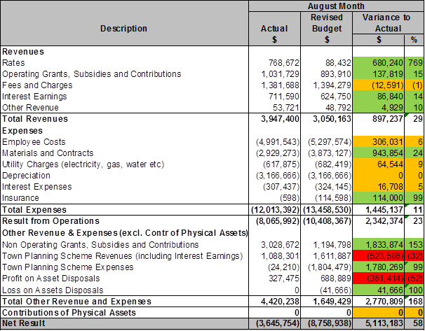
Further to the above table, 2 graphs have been included to illustrate category activity comparison by month.
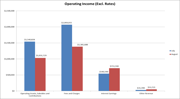
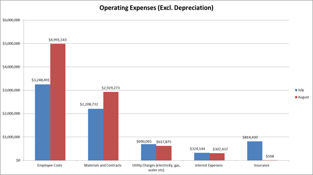
In accordance with the requirement of Regulation 34(5) of the Local Government (Financial Management) Regulations 1996, the commentaries on 10% variances to budget in the Financial Activity Statement for the period ended 31 August 2015 are provided below.
Income Statement (Refer to Attachment 1)
Net Result $ million
Year to Date Actual 118.662
Year to Date Revised Budget 114.413
Year to Date Variance +4.250 (+4%)
Full Year Adopted Budget 80.069
Full Year Revised Budget 76.927
The following information is provided on key aspects of the year to date financial results:
Revenues $ million
Year to Date Actual 136.126
Year to Date Revised Budget 134.737
Year to Date Variance 1.389 (+1%)
Full Year Adopted Budget 170.896
Full Year Revised Budget 167.738
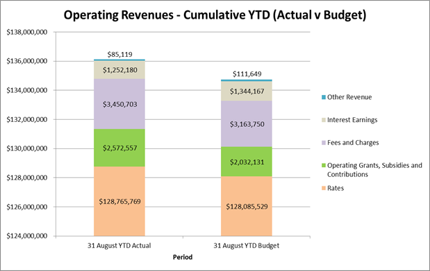
Operating Grants, Subsidies and Contributions
As at 31 August 2015 the YTD variance for Operating Grants, Subsidies and Contributions was $0.540 million (+27%). The positive result continues from July and is still mainly attributed to the receipt of the Kidsport grant ($0.425 million) for the 2015/16 year in July. Whilst the grant is budgeted on a monthly basis the entire amount was received in July. As reported in the July Financial Activity Statement, variances are anticipated to reduce throughout the year and have done so from last month (+97% in July compared to +27% in August).
Approximately 50% of the City’s annual Financial Assistance Grant allocation from the State Government was paid in advance, with $3.196 million received on June 29 2015. The Adopted Budget has been revised down by this amount to reflect the early receipt.
Other Revenue
Other Revenue for August has a YTD variance of -24% (-0.026 million). The main contributor for the variance is August fuel rebates not being received by the end of the month (to occur in September). As the year progresses other categories of income will increase which will negate the lag on fuel rebate receipts attributing to the variance. As stated previously this category of income has a small weighting on the City of Wanneroo.
Expenses $ million
Year to Date Actual 22.478
Year to Date Revised Budget 23.624
Year to Date Variance +1.145 (+5%)
Full Year Adopted Budget 177.620
Full Year Revised Budget 177.604
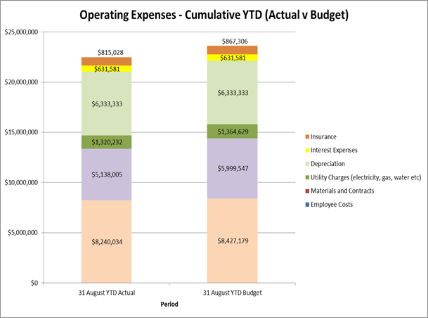
Materials and Contracts
The Materials and Contracts expense category reflect a year to date variance of +14% ($0.862 million). This is mainly due to Contract expenses within the Parks Maintenance division not yet being required. These expenses are however budgeted on a monthly basis as the contract requirements can be ad hoc in nature.
Other Revenue and Expenses $ million
(Excluding Contributions of Physical Assets)
Year to Date Actual 5.014
Year to Date Revised Budget 3.299
Year to Date Variance +1.715 (+52%)
Full Year Adopted Budget 19.793
Full Year Revised Budget 19.793
Non-Operating Grants, Subsidies and Contributions
As at the end of August the income within this category was $3.199 million. This result is a favourable variance of 34% ($0.810 million). Within the month of August the City received $0.800 million from the Department of Infrastructure for various road projects. Main Roads also contributed $1.398 million in grants for various road projects. Non-operating Grants, Subsidies and Contributions relate directly to the external funding towards capital projects.
Town Planning Scheme (TPS) Revenues (including Interest Earnings)
In relation to the TPS Revenues of $1.529 million, $0.852 million has been received by the City from land holders which reflects a year to date variance of -68% (-$2.698 million). Income received for August relating to lot sales was $0.117 million (Cell 4) and $0.642 million (Cell 6). It is noted also that interest income for August amounted to $0.330 million for all Cells with a year to date total of $0.678 million.
TPS Expenses
TPS Expenses as at August month end total $0.042 million, and reflect a positive position of $3.567 million year to date against budget, representing a +99% variance. These expenditures relate to specific costs and land purchases within the Scheme locations and have no impact on municipal accounts.
Profit/Loss on Asset Disposals
As at August month end the City has a total of $0.327 million profit recorded in sales of assets. The income relates to the sale of land within the Tamala Park scheme. Whilst the year to date variance is -$1.050 million (-76%) the nature and timing of sale of assets cannot be determined with certainty, budgets may or may not align on a monthly basis.
Contributions of Physical Assets $ million
Year to Date Actual 0.000
Year to Date Revised Budget 0.000
Year to Date Variance 0.000 (0%)
Full Year Adopted Budget 67.000
Full Year Revised Budget 67.000
Each year developers hand over physical assets such as parklands, roads and pathways to the City, for its ongoing management and control. It should be noted that variations on the amounts of contributions of physical assets comparing to budget has no direct impact to the City’s current financial year results, but can have a significant impact on future servicing, maintenance and renewal costs needing to be factored into the Long Term Financial Plan. The scale of the value of assets handed over to the City in the past has generally aligned closely to the % increase in the number of new Lots created during the financial year.
Balance Sheet (Refer to Attachment 2)
Capital Works Program
The current status of the Capital Works Program as of 31 August 2015 is summarised below by Program Category:-
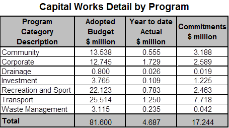
The table above notes a total Adopted Budget for the capital works program as $81.600 million. As at the end of August $4.687 million has been spent against capital works. In addition to the actual expenditure, $17.244 million is recognised as committed. (Note: Commitments are life to date and may also relate to future financial periods).
To further expand on the capital works program information above, key infrastructure projects are selected to be reported on, on a regular basis, which are listed in the following table:
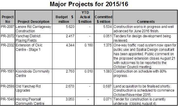
Investment Portfolio Summary (Refer to Attachment 3)
In accordance with the Local Government (Financial Management) Regulations 1996, the City only invests in the following highly secured investments effective from 1 August 2012:
1. Deposits with authorised deposit taking institutions and the Western Australian Treasury Corporation for a term not exceeding 12 months;
2. Bonds that are guaranteed by the Commonwealth Government or a State or Territory for a term not exceeding three years; and
3. Australian currency.
As at 31 August 2015, the City holds an investment portfolio (cash and cash equivalents) of $311.814 million (Face Value). Interest earnings were budgeted at 2.75% yield. For the financial year to date ending August 2015, Council’s investment portfolio return has exceeded the bank bill index benchmark by 0.80% pa (3.30% pa vs. 2.51% pa).
Displayed below are graphical representations of the portfolio performance and earnings:
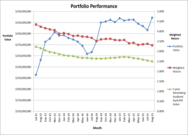
Note: Interest Earnings = Interest on investments plus Rates Instalment and Penalty Income.
Rate Setting Statement (Refer to Attachment 4)
The Rate Setting Statement outlined in Attachment 4 represents a composite view of the finances of the City, identifying the movement in the surplus/(deficit), primarily based on the operations and capital works revenue and expenditure, and resulting rating income required.
Overall Comment
The Result from Operations for the City to August month end presents an overall favourable variance of $4.249 million (+4%) to year to date budget. Operating Revenue presented a favourable variance to year to date budget of $1.389 million (1%). Expenditures from Operations also present an favourable variance to budget of $1.145 million (+5%) with the main contributor being Materials and Contracts (+$0.862 million).
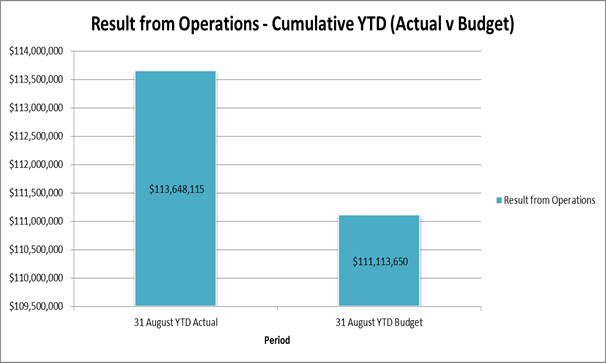
Statutory Compliance
This monthly financial report complies with Section 6.4 of the Local Government Act 1995 and Regulations 33A and 34 of the Local Government (Financial Management) Regulations 1996.
Strategic Implications
The proposal aligns with the following objective within the Strategic Community Plan 2013 – 2023:
“4 Civic Leadership - Working with others to ensure the best use of our resources.
4.3 A Strong and Progressive Organisation - You will recognise the hard work and professionalism delivered by your council through your interactions and how our community is developing.”
Risk Management Considerations
|
Risk Title |
Risk Rating |
|
Financial Management |
Moderate |
|
Accountability |
Action Planning Option |
|
Executive Management Team |
Manage |
The above risk relating to the issue contained within this report has been identified and considered within the City’s corporate risk register. Action plans have been developed to manage this risk to improve the existing management systems.
Policy Implications
Nil
Financial Implications
As outlined above and detailed in Attachments 1, 2, 3 and 4.
Voting Requirements
Simple Majority
That Council RECEIVES the Financial Activity Statements and commentaries on variances to Year to Date Budget for the period ended 31 August 2015, consisting of:
1. 2015/16 Annual Adopted and Revised Budget;
2. August 2015 Year to Date Revised Budget;
3. August 2015 Year to Date Income and Expenditure;
4. August 2015 Year to Date Material Variance Notes; and
5. August 2015 Year to Date Net Current Assets.
Attachments:
|
1. |
August Income Statement |
15/484631 |
Minuted |
|
2. |
August Balance Sheet |
15/484636 |
Minuted |
|
3. |
August Inv |
15/484638 |
Minuted |
|
4. |
August Rate Setting Statement |
15/484635 |
Minuted |
CITY OF WANNEROO Agenda OF Elected Members' Briefing Session 06 October, 2015 296
Governance and Legal
File Ref: 2374 – 15/297060
Responsible Officer: Director Corporate Strategy and Performance
Disclosure of Interest: Nil
Attachments: 1
Issue
To consider the schedule of meeting dates for 2016.
Background
Local Government (Administration) Regulations 1996 Section 12 requires that a local government is to give local public notice of its Ordinary meeting dates for the next 12 months.
Detail
The four week meeting cycle is working well and it is suggested that this system be maintained with the exception that the Audit & Risk Committee meeting dates have been set to coincide with critical dates identified by the City’s Risk and Business Improvement and Finance Service Units to better align with reporting requirements. Additionally, due to the Easter holiday break, Administration recommends that the Council meeting scheduled for 29 March 2015 be postponed for a week. There will therefore be a two week break between the Briefing Session and the Council meeting.
Briefing Sessions will continue to commence at 6.00pm and Council Meetings at 7.00pm subject to any changes Council may wish to make to the City’s Standing Orders Local Law that may impact on the inclusion of deputations within the Council Meeting.
Consultation
Nil
Comment
The Annual General Meeting of Electors (AGM) has been scheduled prior to the first and last Briefing Sessions of 2016
The timing of the acceptance of the annual report is dependent on when the External Auditor's Report becomes available as this will impact on the date set for the Annual General Meeting. The Audited Financial Statements (rather than the full Annual Report) is required to be considered by the Audit & Risk Committee prior to being included in the Annual Report and subsequent presentation to Council for adoption.
During an Election Year, a number of meeting dates are set aside to accommodate induction sessions for new Elected Members. These impact on the ability for the City to present the Annual Report to Council for adoption prior to the last meeting of the year which then requires that the AGM be held prior to the Briefing Session in the new year (required to be within 56 days of the adoption of the Annual Report by Council). In a “non-election” year, there is no requirement to postpone the AGM and it can be held prior to the last Briefing Session of that year.
Statutory Compliance
Local Government Act 1995
Part 5 – Administration
Division 2 – Council meetings, committees and their meetings and electors’ meetings
S5.3 – Ordinary and special council meetings
“(1) A council is to hold ordinary meetings and may hold special meetings.
(2) Ordinary meetings are to be held not more than 3 months apart.
(3) If a council fails to meet as required by subsection (2) the CEO is to notify the Minister of that failure.”
Local Government (Administration) Regulations 1996
R12 – Public notice of council or committee meetings – s. 5.25(1)(g)
“(1) At least once each year a local government is to give local public notice of the dates on which and the time and place at which –
(a) the ordinary council meetings; and
(b) the committee meetings that are required under the Act to be open to members of the public or that are proposed to be open to members of the public,
are to be held in the next 12 months.”
Strategic Implications
The proposal aligns with the following objective within the Strategic Community Plan 2013 – 2023:
“4 Civic Leadership - Working with others to ensure the best use of our resources.
4.3 A Strong and Progressive Organisation - You will recognise the hard work and professionalism delivered by your council through your interactions and how our community is developing.”
Risk Management Considerations
Nil
Policy Implications
Nil
Financial Implications
Nil
Voting Requirements
Simple Majority
Recommendation
That Council ADOPTS the meeting schedule detailed in Attachment 1 for 2016 meeting rounds.
Attachments:
|
1. |
Proposed Council Meeting Dates for 2016 |
15/479502 |
|
CITY OF WANNEROO Agenda OF Elected Members' Briefing Session 06 October, 2015 300
File Ref: 2855V02 – 15/483629
Responsible Officer: Director Corporate Strategy and Performance
Disclosure of Interest: Nil
Attachments: Nil
Issue
To consider requests for sponsorships, donations and waiver of fees in accordance with the City’s Donations, Sponsorships and Waiver of Fees and Charges Policy (Policy).
Background
The Policy requires applications over $500 from individuals and organisations to be determined by Council. Consequently a report is prepared for Council meetings, coinciding with a period where applications of this nature have been received.
With respect to requests for sponsorships, the Policy specifies that for National Events the amount provided will be $200.00 per individual, capped at $600.00 per team, and for International Events the amount provided is $500.00 per individual capped at $1,500.00 per team. Schools are capped at $2,000.00 per school per financial year.
Detail
During this period, the City has received six sponsorship requests, nil community donation request and nil request for a waiver of fees and charges, which are summarised as follows. Copies of the full applications are available from Governance upon request.
Comment
Sponsorship Donations
|
Applicant 1 – School Sport Western Australia Inc |
|
|
Name of Individual/s
|
Jackson Pickett, Kate Campbell, Ella Thonrton-Elliott, Jayden Coburn and Thomas Holyoak |
|
Reside in City of Wanneroo 18years of age or under |
Yes Yes |
|
Event Details |
2015 Pacific School Games – Basketball, Adelaide SA 20 – 29 November 2015 |
|
Commitment to providing a written report regarding the event |
Yes |
|
Commitment to acknowledgement of the City of Wanneroo |
Yes |
|
Eligibility Level |
National |
|
Comments
|
In accordance with the Policy, $200 per individual (capped at $600 per team, up to four teams). |
|
Recommendation
|
APPROVE a request for sponsorship in the sum of $600.00 to School Sport Western Australia Inc for the participation of Jackson Pickett, Kate Campbell, Ella Thonrton-Elliott, Jayden Coburn and Thomas Holyoak at the 2015 Pacific School Games – Basketball to be held in Adelaide SA from 20 – 29 November 2015. |
|
|
This request is in accordance with Council’s Policy. |
|
Applicant 2 – School Sport Western Australia Inc |
|
|
Name of Individual/s
|
Tahlia Reiri-TeRito, Tamati Mako, Tennae Berryman, Anahera Te Rahui, Mythiaz Taipari Raureti Heather, Austin Anderson, Zion Taurima and Tyree Mau |
|
Reside in City of Wanneroo 18years of age or under |
Yes Yes |
|
Event Details |
2015 Pacific School Games – Touch Football, Adelaide SA, 20 – 29 November 2015 |
|
Commitment to providing a written report regarding the event |
Yes |
|
Commitment to acknowledgement of the City of Wanneroo |
Yes |
|
Eligibility Level |
National |
|
Comments |
In accordance with the Policy, $200 per individual (capped at $600 per team, up to four teams). |
|
Recommendation
|
APPROVE a request for sponsorship in the sum of $600.00 to School Sport Western Australia Inc for the participation of Tahlia Reiri-TeRito, Tamati Mako, Tennae Berryman, Anahera Te Rahui, Mythiaz Taipari Raureti Heather, Austin Anderson, Zion Taurima and Tyree Mau at the 2015 Pacific School Games – Touch Football to be held in Adelaide SA from 20 – 29 November 2015. |
|
|
This request is in accordance with Council’s Policy. |
|
Applicant 3 – School Sport Western Australia Inc |
|
|
Name of Individual/s
|
Piper Boobyer, Josiah Godfrey and Jacob Mustafa |
|
Reside in City of Wanneroo 18years of age or under |
Yes Yes |
|
Event Details |
2015 Pacific School Games – Football 19s, Adelaide SA, 20 – 29 November 2015 |
|
Commitment to providing a written report regarding the event |
Yes |
|
Commitment to acknowledgement of the City of Wanneroo |
Yes |
|
Eligibility Level |
National |
|
Comments |
In accordance with the Policy, $200 per individual (capped at $600 per team, up to four teams). |
|
Recommendation
|
APPROVE a request for sponsorship in the sum of $600.00 to School Sport Western Australia Inc for the participation of Piper Boobyer, Josiah Godfrey and Jacob Mustafa at the 2015 Pacific School Games – Football 19s to be held in Adelaide SA from 20 – 29 November 2015. |
|
|
This request is in accordance with Council’s Policy. |
|
Applicant 4 – North Coast Rangers Christian Football Club |
|
|
Name of Individual/s
|
U16 Girls - Dekenesh Hayes and Alexandra Robinson U16 Boys – Tristan Mansell and Johan Kriel U14 Boys – Kieran Moores |
|
Reside in City of Wanneroo 18years of age or under |
Yes Yes |
|
Event Details |
CFFA 2015 National Christian Football Titles, Sydney NSW, 28 September to 1 October 2015 |
|
Commitment to providing a written report regarding the event |
Yes |
|
Commitment to acknowledgement of the City of Wanneroo |
Yes |
|
Eligibility Level |
National |
|
Comments |
In accordance with the Policy, $200 per individual (capped at $600 per team, up to four teams). |
|
Recommendation
|
APPROVE a request for sponsorship in the sum of $1,000.00 to North Coast Rangers Christian Football Club for the participation of U16 Girls - Dekenesh Hayes and Alexandra Robinson; U16 Boys – Tristan Mansell and Johan Kriel and U14 Boys – Kieran Moores at the CFFA 2015 National Christian Football Titles held in Sydney NSW from 28 September to 1 October 2015. |
|
|
This request is in accordance with Council’s Policy. |
|
Applicant 5 – ATI Martial Arts |
|
|
Name of Individual/s
|
Stefan, Daniel and Nikolas Vojnovic |
|
Reside in City of Wanneroo 18years of age or under |
Yes Yes |
|
Event Details |
National Taekwondo Tournament, Adelaide SA, 2 – 4 October 2015 |
|
Commitment to providing a written report regarding the event |
Yes |
|
Commitment to acknowledgement of the City of Wanneroo |
Yes |
|
Eligibility Level |
National |
|
Comments |
In accordance with the Policy, $200 per individual (capped at $600 per team, up to four teams). |
|
Recommendation
|
APPROVE a request for sponsorship in the sum of $600.00 to ATI Martial Arts for the participation of Stefan, Daniel and Nikolas Vojnovic at the National Taekwondo Tournament to be held in Adelaide SA from 2 – 4 October 2015. |
|
|
This request is in accordance with Council’s Policy. |
|
Applicant 6 – O’Brien Academy of Irish Dancing |
|
|
Name of Individual/s
|
Dakota Courtney, Matilda Dillon and Cassandra Perkins |
|
Reside in City of Wanneroo 18years of age or under |
Yes Yes |
|
Event Details |
2015 Australian Irish Dance National Championship, Sydney NSW, 29 September to 3 October 2015 |
|
Commitment to providing a written report regarding the event |
Yes |
|
Commitment to acknowledgement of the City of Wanneroo |
Yes |
|
Eligibility Level |
National |
|
Comments |
In accordance with the Policy, $200 per individual (capped at $600 per team, up to four teams). |
|
Recommendation
|
APPROVE a request for sponsorship in the sum of $600.00 to O’Brien Academy of Irish Dancing for the participation of Dakota Courtney, Matilda Dillon and Cassandra Perkins at the 2015 Australian Irish Dance National Championship held in Sydney NSW from 29 September to 3 October 2015. |
|
|
This request is in accordance with Council’s Policy. |
Statutory Compliance
Nil
Strategic Implications
The proposal aligns with the following objective within the Strategic Community Plan 2013 – 2023:
“2 Society - Healthy, safe, vibrant and active communities.
2.2 Healthy and Active People - We get active in our local area and we have many opportunities to experience a healthy lifestyle.”
Risk Management Considerations
Nil
Policy Implications
The Policy states that sponsorship applications for attendance at National Events will be capped at $600.00 per team (up to four teams) and Regional or State capped at $600 per club. International events will be capped at $1,500.00 per team and schools capped at $2,000.00 per school per financial year.
Financial Implications
|
Budget 2015/2016 |
|
$90 000.00 |
|
Amount expended to date (as at 29 September 2015) |
|
$29,478.80 |
|
Balance |
|
$60,521.20 |
|
Total of requests for this round: Donations (in this report):
Total this Round (recommended) |
$4,000.00
|
$4,000.00 |
|
BALANCE |
|
$56,521.20 |
Voting Requirements
Simple Majority
That Council:-
1. APPROVES a request for sponsorship in the sum of $600.00 to School Sport Western Australia Inc for the participation of Jackson Pickett, Kate Campbell, Ella Thonrton-Elliott, Jayden Coburn and Thomas Holyoak at the 2015 Pacific School Games – Basketball to be held in Adelaide SA from 20 – 29 November 2015;
2. APPROVES a request for sponsorship in the sum of $600.00 to School Sport Western Australia Inc for the participation of Tahlia Reiri-TeRito, Tamati Mako, Tennae Berryman, Anahera Te Rahui, Mythiaz Taipari Raureti Heather, Austin Anderson, Zion Taurima and Tyree Mau at the 2015 Pacific School Games – Touch Football to be held in Adelaide SA from 20 – 29 November 2015;
3. APPROVES a request for sponsorship in the sum of $600.00 to School Sport Western Australia Inc for the participation of Piper Boobyer, Josiah Godfrey and Jacob Mustafa at the 2015 Pacific School Games – Football 19s to be held in Adelaide SA from 20 – 29 November 2015;
4. APPROVES a request for sponsorship in the sum of $1,000.00 to North Coast Rangers Christian Football Club for the participation of U16 Girls - Dekenesh Hayes and Alexandra Robinson; U16 Boys – Tristan Mansell and Johan Kriel and U14 Boys – Kieran Moores at the CFFA 2015 National Christian Football Titles held in Sydney NSW from 28 September to 1 October 2015;
5. APPROVES a request for sponsorship in the sum of $600.00 to ATI Martial Arts for the participation of Stefan, Daniel and Nikolas Vojnovic at the National Taekwondo Tournament to be held in Adelaide SA from 2 – 4 October 2015; and
6. APPROVES a request for sponsorship in the sum of $600.00 to O’Brien Academy of Irish Dancing for the participation of Dakota Courtney, Matilda Dillon and Cassandra Perkins at the 2015 Australian Irish Dance National Championship held in Sydney NSW from 29 September to 3 October 2015.
Attachments: Nil
CITY OF WANNEROO Agenda OF Elected Members' Briefing Session 06 October, 2015 306
File Ref: 2418 – 15/469092
Responsible Officer: Director Corporate Strategy and Performance
Disclosure of Interest: Nil
Attachments: 1
Previous Items: CS02-06/15 Agenda; CS02-06/15 Minutes
Proposed Penalties Local Law
Issue
To consider adopting the Penalty Units Local Law as part of the City’s 8 Year Local Law Review (Review) required by the Local Government Act 1995 (Act).
Background
The City is currently undertaking the Review. Many of the City's Local Laws were made in 1999, and were contemporary in their day, but now require updating and in many cases replacing.
As part of the Review, the Administration is considering all opportunities to introduce new measures to streamline administration of its local laws. One of the measures identified is to introduce a Penalty Units Local Law (PU Local Law). While it has no direct external or public effect, its early introduction will allow any new or amended local law to reference the PU Local Law and have consistency across all of the City's Local Laws in respect of penalties.
The PU Local Law provides for penalty units instead of precise dollar amounts as set out in the schedules of modified penalties (on the spot fines) in each Local Law.
This is very similar to Regulations and Codes used in State legislation. If there is a need to broadly amend penalties across the Local Laws in future, it will be a case of simply amending the amount provided for as a penalty unit in the PU Local law, instead of amending each Local Law individually. Note that this does not preclude the City from detailing precisely what the dollar amounts might be for offences in administrative material, on signs, on its website or in handouts to the public. The intent is simply to make it easier to update infringement amounts in future.
Detail
The proposed City of Wanneroo Penalty Units Local Law 2015 is attached at Attachment 1. It provides that whenever a Local Law refers to a penalty unit, the applicable amount of each penalty unit is $10.00.
Consultation
The draft PU Local Law was presented to an Elected Members Forum held on 5 March 2015 were a number of comments were raised and considered by Administration. As a result, further discussion with internal stakeholders and assessment of current practices occurred and were discussed with Elected Members at the 2 June 2015 Members Forum. The outcomes were incorporated into a proposed new draft Penalty Units Local Law, which was adopted by Council at its meeting held on 23 June for the purposes of public advertising.
The draft local law was advertised for public comment for a 7 week period closing on 31 August 2015.
No comments were received from the public. The WA Department of Local Government and Communities recommended a number of minor edits, which have been included.
Comment
The amendments suggested are shown ‘marked up’ on the attached City of Wanneroo Penalty Units Local Law 2015 and are considered minor in nature.
The local law can now be finalised, and will come into effect 14 days after its publication in the Government Gazette.
Purpose:
The objective of the proposed Penalty Units Local Law is to set the amount of a
penalty unit referred to in any other Local Law.
Effect:
Where a Local Law refers to a penalty unit, the amount is as set in the Penalty
Units Local Law.
Statutory Compliance
Section 3.12 of the Local Government Act 1995 sets out the requirements for making a local law.
Strategic Implications
The proposal aligns with the following objective within the Strategic Community Plan 2013 – 2023:
“4 Civic Leadership - Working with others to ensure the best use of our resources.
4.3 A Strong and Progressive Organisation - You will recognise the hard work and professionalism delivered by your council through your interactions and how our community is developing.”
Risk Management Considerations
This local law does not have any direct implications in itself; however making it will allow the City to make changes to modified penalties in local laws easier in future.
Policy Implications
Nil
Financial Implications
There are costs associated with making the local law, including advertising and eventual Gazettal.
Voting Requirements
Absolute Majority
That Council:-
1. ADOPT BY ABSOLUTE MAJORITY, in accordance with section 3.12(4) of the Local Government Act 1995, the City of Wanneroo Penalty Units Local Law 2015 subject to various minor amendments as ‘marked up’ on Attachment 1;
2. NOTE the purpose and effect of the City of Wanneroo Penalty Units Local Law 2015 ;
Purpose: The objective of this local law is to set the amount of a penalty unit where referred to in any of the City’s local laws; and
Effect: Where a local law refers to a penalty unit, the amount is as set in the Penalty Units local law.
3. REQUEST Administration, in accordance with s3.12(5) of the Local Government Act 1995, publish the City of Wanneroo Penalty Units Local Law 2015 in the Government Gazette and send a copy to the Minister for Local Government and Communities;
4. NOTES that after Gazettal, in accordance with s3.12(6) of the Local Government Act 1995, local public notice be given;
a) Stating the title of the local law;
b) Summarising the purpose and effect of the local law (specifying the day on which it comes into operation); and
c) Advising that copies of the local law may be inspected or obtained from the City office and
5. NOTES that following Gazettal, in accordance with the Local Laws Explanatory Memoranda Directions as issued by the Minister on 12 November 2010, a copy of the local law and a duly completed explanatory memorandum signed by the Mayor and Chief Executive Officer be sent to the Western Australian Parliamentary Joint Standing Committee on Delegated Legislation.
Attachments:
|
1. |
Penalty Units Local Law |
15/469095 |
Minuted |
CITY OF WANNEROO Agenda OF Elected Members' Briefing Session 06 October, 2015 311
File Ref: 2418 – 15/469159
Responsible Officer: Director Corporate Strategy and Performance
Disclosure of Interest: Nil
Attachments: 1
Previous Items: CS04-06/15 Agenda; CS04-06/15 Minutes
Proposed Waste Management Local Law
Issue
To consider a new Waste Local Law (WLL) for adoption as part of the City’s 8 Year Local Law Review (Review) required by the Local Government Act 1995 (the Act).
Background
The City is in the process of updating its local laws. Many were made in 1999, and were contemporary in their day, but require updating to the point where replacement in many instances is warranted, and are being presented to Council on a case by case basis.
The City’s Health Local Law currently deals with waste. It was made in 1999 and has been updated as required. Part 5 of the local law deals with waste and refuse. It is affected by the Waste Avoidance and Resource Recovery Act (WARR Act) which came into force on 1 July 2008.
This Act repealed various provisions of the Health Act that dealt with the powers of local governments in relation to the collection and removal of rubbish, and had the effect of transferring the powers of a local government to make local laws about waste to the WARR Act (item 4 of Schedule 4).
Provisions about liquid waste are dealt with under the Environmental Protection (Unauthorised Discharges) Regulations 2004, and litter or dumping under the Litter Act 1979.
Local laws are however subject to review by the Parliamentary Joint Standing Committee (JSC). The Committee has recently formed the view that notwithstanding earlier versions of this local law made by other local governments that sought to also deal with waste from commercial premises, the WARR Act only allows local governments to make local laws about refuse from residential premises.
As such:
· waste collection and removal from residential property can be regulated under the proposed Waste Local Law, which contains greatly improved enforcement provisions not available for local laws made under the Health Act; and
· waste collection and removal from non-residential property will need to continue to be regulated under the existing Health Local Law 1999. Any local laws that were previously made by a local government under the old provisions of the Health Act 1911 that were in force on 1 July 2008 remain in force under the saving and transitional provisions of the WARR Act.
The situation is not ideal, but given that most issues encountered by the City relate to residential property, the proposed Waste Local Law should assist.
Detail
The proposed Waste Local Law is attached at Attachment 1. It is based on a model provided by the WA Local Government Association.
The draft local law is divided into 4 Parts:
1. Definitions;
2. Disposal of refuse – this Part deals with rubbish receptacles, placement on streets for collection, the use of receptacles and what may be placed in them, and other provisions to ensure that waste is able to be removed efficiently.
3. Operation of Waste facilities;
4. Dealing with the need to require waste receptacles on building sites (which currently sits in the City’s Private Property Local Law 1999); and
5. Enforcement provisions – including a Schedule of modified penalties that may be imposed as listed in Schedule 1. These provisions are a significant improvement on the provisions allowable under the existing Health Local Law and include provisions such as:
a) For a minimum fine to be imposed if a matter proceeds to a court hearing – other local governments have had a rather disappointing experience of magistrates occasionally imposing a fine less than the original modified penalty;
b) Provisions tying modified penalties in Schedule 1, to the amounts set out in the City’s proposed Penalty Units Local Law. This will allow for ease of updating modified penalties in future without the need to amend a whole raft of local laws.
The proposed WLL repeals those clauses in Part 5 of the City’s Health Local Law 1999 that deal with residential waste collection and removal.
In itself, the City’s Health Local Law 1999 may be reviewed when the Public Health Bill becomes law, but for now it is considered that provisions allowing the City some measure of control over commercial premises should be retained until that occurs.
Consultation
A draft WLL was presented to an Elected Members Forum held on 17 February 2015 where a number of comments were made, and again on 2 June. The outcomes were incorporated into a proposed new draft WLL, which was adopted by Council at its meeting held on 23 June for the purposes of public advertising.
The proposed WLL was advertised for public comment for a 7 week period closing on 31 August 2015.
No comments were received from the public, the Minister for Health or the Minister for the Environment.
The WA Department of Local Government and Communities made a number of comments on behalf of the Minister for Local Government:
|
Comment |
Recommended action |
|
1. Waste local laws The Department notes that the City’s local law appears to be based on the new model prepared by WALGA and the Department of Environmental Regulation. The Joint Standing Committee on Delegated Legislation has made a preliminary analysis of the model and provided their general approval for the content. However, the Committee noted in its 77th Report that: …its general approval of the proposed template should not be taken as meaning that the Committee could not still recommend disallowance of a waste local law drafted in accordance with the final template. While the City’s local law is much improved from the waste local laws disallowed by the Committee in the past, the City should be prepared for the possibility that the Committee may still raise concerns with the local law. It is suggested that the City consult the Committee’s 77th Report for an idea of what kind of issues the Committee will investigate. |
Noted. The local law seeks to address any matters that may be of concern as raised by the Committee in its 77th Report. |
|
2. Page numbers It is suggested that page numbers be removed, as the Government Gazette has its own page numbering system and there is no guarantee the page numbers will remain accurate after the local law has been published. This suggestion only applies to the gazettal version. If the City can still retain the page numbers in administrative copies of the local law if it wishes to do so. |
Noted and agreed. This is reflected in the recommendation to Council. |
|
3. Clause 1.4 The Department notes that the City’s Health Local Law has been amended since its original gazettal in 1999. It is suggested that the amendment be noted. The following is provided as a drafting example only: --- The City of Wanneroo Health local Law 1999, as published in the Government Gazette on 27 August 1999 and as amended in the Government Gazette on 11 June 2002, is amended as follows:
|
Amended accordingly. |
|
4. Prosecution of property owners for conduct of third parties A number of clauses in the local law appear to hold the property owner responsible for offences committed by other people, even when the offence was committed without the owner’s knowledge or permission. The City may wish to consider changing these requirements so the property owner must “take all reasonable steps” to ensure the receptacle is used in compliance with the law.
|
This provision (to take ‘all reasonable steps’) is already in several places such as clauses 2.7 and 3.1.
This amended is included in clause 2.1(2) which should ameliorate any concerns in this regard. |
|
Comment |
Recommended action |
|
5. Clause 2.7 Clause 2.7(a) provides that receptacles must be kept away from the street except for a reasonable period before and after collection time. As the paragraph is currently written, it may be interpreted to provide that removing the receptacle from storage on collection days is required. The City may wish to redraft this, or provide that a receptacle only needs to be placed for collection if it contains rubbish during collection time. The City may also wish to clarify the term “reasonable period” in further detail. The term is likely to be interpreted in a variety of ways by the people who read the local law and this may lead to misunderstandings over what the local law requires.
|
This clause is quite clear – it does not require a bin to be removed from storage on collection days. Its purpose is simply to ensure bins are not left on verges for extended periods. No amendment is required.
Exactly what a ‘reasonable period’ before a rubbish collection is undertaken will vary depending on individual circumstances, how long the City or its contractor may take to undertake a collection round, and more. Clause 2.7(b) also provides for a person to ‘take reasonable steps’ to ensure that a bin is placed within a metre of a road edge, etc. It is considered that most if not all issues that may arise with bins not being correctly placed would be resolved simply by requesting the owner or occupier to change behaviour. If the problem were to continue and an infringement were to be issued or prosecution undertaken then the onus would be on the City to show what was ‘reasonable’ for a decision by a judge or magistrate. No amendment is required. |
|
6. Schedule 1 – Meaning of non-collectable waste Clause 1.5 defines non-collectable waste as being any kind of waste prescribed in Schedule 2. Schedule 2 is quite proscriptive. However, the final paragraph provides that the City can ‘determine’ any kind of waste as non-collectable waste. The Delegated Legislation Committee has traditionally objected to the use of determination devices except for simple administrative matters. While the provision of public disclosure procedures under clause 1.6 may satisfy the Committee, there is no guarantee this will be the case. It is suggested that the City review paragraph (l) of Schedule 1 and consider whether the preceding paragraphs already provide enough restrictions to suit the City’s requirements. |
Noted. The composition and nature of waste is however constantly changing, and may require constant amendment to the local law if the DLG’s suggestion is taken up. As noted, determinations are subject to the process under clause 1.6, and in order to remove any doubt, paragraph (l) of Schedule 1 has been recommended so that it reads ‘(l) any other waste determined by the local government under clause 1.6 to be non-collectable waste.’ |
The Department also recommended a number of minor edits, which have been undertaken.
Comment
The amendments suggested are shown ‘marked up’ in the attached WLL and are considered minor in nature.
The WLL can now be finalised, and will come into effect 14 days after its publication in the Government Gazette.
Statutory Compliance
Section 3.12 of the Local Government Act 1995 sets out the requirements for making a local law.
Strategic Implications
The proposal aligns with the following objective within the Strategic Community Plan 2013 – 2023:
“4 Civic Leadership - Working with others to ensure the best use of our resources.
4.3 A Strong and Progressive Organisation - You will recognise the hard work and professionalism delivered by your council through your interactions and how our community is developing.”
Risk Management Considerations
Nil
Policy Implications
This proposed WLL does not have any direct policy implications itself, however making it will allow the City to better deal with issues associated with waste collection and disposal.
Financial Implications
There are costs associated with making the local law, including advertising and eventual Gazettal.
Voting Requirements
Absolute Majority
That Council:-
1. ADOPTS BY ABSOLUTE MAJORITY, In accordance with section 3.12(4) of the Local Government Act 1995, the City of Wanneroo Waste Local Law 2015 subject to:
a. deletion of text boxes, page numbers in the index and notes in the version to be officially Gazetted; and
b. various other amendments as ‘marked up’ in Attachment 1 to the report to Council;
2. NOTES the purpose and effect of the local law:-
Purpose: The objective of this Waste Local Law is to regulate the storage, collection and disposal of waste and refuse from residential premises and on waste facilities in the City.
Effect: Unless otherwise authorised, the storage, collection and disposal of waste and refuse within the City must be carried out in accordance with the provisions of the Waste Local Law.
3. REQUESTS Administration, in accordance with s3.12(5) of the Local Government Act 1995, publish the local law in the Government Gazette and send a copy to the Ministers for Local Government, Health and the Environment;
4. NOTES that after Gazettal, in accordance with s3.12(6) of the Local Government Act 1995, local public notice be given:-
a. stating the title of the local law;
b. summarising the purpose and effect of the local law (specifying the day on which it comes into operation); and
c. advising that copies of the local law may be inspected or obtained from the City office; and
5. NOTES that following Gazettal, in accordance with the Local Laws Explanatory Memoranda Directions as issued by the Minister on 12 November 2010, a copy of the local law and a duly completed explanatory memorandum signed by the Mayor and Chief Executive Officer be sent to the Western Australian Parliamentary Joint Standing Committee on Delegated Legislation.
Attachments:
|
1. |
Waste Management LL Final for Council adoption.docx |
15/469156 |
|
CITY OF WANNEROO Agenda OF Elected Members' Briefing Session 06 October, 2015 335
File Ref: 2418 – 15/469230
Responsible Officer: Director Corporate Strategy and Performance
Disclosure of Interest: Nil
Attachments: 1
Previous Items: CS03-06/15 Agenda; CS03-06/15 Minutes
Proposed Parking Local Law
Issue
To consider the Parking Local Law (PLL) for adoption as part of the City’s 8 Year Local Law Review (Review) required by the Local Government Act 1995 (Act).
Background
The City is in the process of updating its local laws. Many were made in 1999, and were contemporary in their day, but require updating to the point where replacement in many instances is warranted, and are being presented to Council on a case by case basis.
Notwithstanding that the City’s existing Parking and Parking Facilities Local Law (P&PF Local Law) is adequate, it was made in 2003 and requires a significant number of amendments and changes to deal with current issues affecting the City. Therefore, a new Local Law is recommended.
Detail
A proposed City of Wanneroo Parking Local Law 2015 is attached at Attachment 1. The PPL is based on a local law developed by the City of Stirling in late 2008, which in turn was based on a model provided by the WA Local Government Association.
Some salient points are:
· Part 2 deals with metered zones. As is the case with its current P&PF Local Law, the City may not have any use for this Part in the immediate future, and its inclusion does not require it to introduce paid parking either. This Part simply continues the ability of the City to do so if it wishes.
· Clause 4.2 deals with parking permits. This clause is widely scoped to give the City the ability to deal with a variety of situations, as well as any issues that may presently be confronting it such as residents who may be having difficulties with commuters parking around train stations and the like. The PLL establishes the ability for the City to issue permits and provides for a penalty if the correct permit is not displayed.
Council policies or resolutions, or delegated authority can then be used to establish matters such as:
o Eligibility for a permit;
o How many permits might be issued;
o If a permit expires annually or carries on indefinitely;
o Times of the day or week that restrictions might apply;
o Circumstances under which infringements might or might not be withdrawn; and
o Any fee that might be payable to issue a permit or replace a lost one.
· Parking stations are simply established by the City under clause 1.4. Extending the PLL to private property can be done by agreement, without the need to change the PLL. This could be done by the CEO under delegated authority and subject to whatever conditions Council might put upon the delegation, but would prove particularly useful if the City was of a mind to use the PLL to (for example) assist a business affected by long term parkers who might also not be customers; and similarly as part of any agreement to extend the local law to private property, the City might require signs to be erected to the standard set in the local law.
· References to ACROD parking permits (ie the need for a person with a disability to display a permit issued under the rules of the Australian Council for the Rehabilitation of the Disabled (WA) to parked in specially marked and sized bays) have been replaced with references to ‘disability parking permits’, which came into effect with the making of the new Local Government (Parking for People with Disabilities) Regulations 2014.
· The majority of infringements issued by the City are for to parking on footpaths. Clause 4.7 makes it an offence for a vehicle to be parked on or over any footpath or pedestrian crossing.
· Clause 7.9 provides that parking on a verge without the consent of the adjoining occupier is an offence, as is the case under the current P&PF Local Law.
· Enforcement provisions in Part 9 are similar to what the City has in place at present but include additional provisions such as:-
o For a minimum fine to be imposed if a matter proceeds to a court hearing; and
o Provisions tying modified penalties in Schedule 2, to the amounts set out in the City’s proposed Penalty Units Local Law. This will allow for ease of updating modified penalties in future without the need to amend a whole raft of local laws.
· Note that while they do not form part of the proposed PLL, relevant extracts from Acts and Regulations that affect the subject area have been included as notes and text boxes in the body of the draft PLL to assist with gaining a full understanding. The official version to be Gazetted will not contain these notes or text boxes, as reflected in the recommendation to Council below.
Consultation
A draft PLL was presented to an Elected Members Forum held on 17 February and 2 June 2015 where a number of comments by Elected Members were noted. The outcomes were incorporated into a proposed new draft PLL, which was adopted by Council at its meeting held on 23 June for the purposes of public advertising.
The draft PLL was advertised for public comment for a 7 week period closing on 31 August 2015.
One comment was received from a member of the public who requested that the City consider making a blanket ‘no parking’ zone on verges within 20m of the approach side to bus stops, and cited a case in his street where the occupants of a particular property allegedly create sight distance obstructions by parking on the median strip, verge and footpath.
The City’s current P&PF Local Law and the proposed new PLL both provide a prohibition with respect to parking on the road carriageway on the approach to bus stops, but not on verges.
In most cases no problems are created, particularly given the brief use of the road area by buses picking up and setting down passengers. While no amendment to the proposed PLL is recommended, the City’s Rangers have attended the particular location identified by the resident on a number of occasions and issued infringements where vehicles have been parked on an adjoining median strip and across footpaths. This compliance regime will continue. An investigation was also undertaken of the sight distances in the area referred to by the resident to determine if a ‘no parking on verge’ restriction may be appropriate. It has been determined that no changes are considered necessary.
The WA Department of Local Government and Communities made a number of comments on behalf of the Minister for Local Government:
|
Comment |
Recommended action |
|
1. Page numbers: It is suggested that the local law does not include page numbers in the contents page or throughout the local law. This is because the page numbers may not remain accurate after the local law is published in the Government Gazette.
In the event that the City chooses to maintain a public version of the local law in hard copy or electronic format, the City can choose to retain the page numbers.
|
Noted and agreed. This is reflected in the recommendation to Council. |
|
2. Boxed notes referring to legislation The local law currently contains boxed notes referring to legislative provisions. The Delegated Legislation Committee has previously indicated its concerns in reproducing legislation in notes in local laws. The Committee is of the view that repeating the text of sections of other legislation as part of the local law may lead to confusion in cases where that legislation text is later amended.
It is suggested that all notes and boxes in the local law are deleted. The City may include this information as part of an “administration version” of the local law to assist the public. This administration version may be made available at the City’s offices but would not be in the official gazetted version of the local law.
|
Noted and agreed. This is reflected in the recommendation to Council. |
|
3. Clause 1.5 – Definitions The definition of “bicycle path” should be deleted as it is not used anywhere else in the local law. |
Agreed. |
|
Comment |
Recommended action |
|
4. Australian standards – definition of symbols In clause 1.5, the definition of symbol makes reference to Australian Standards.
The City should ensure that the citation of the relevant Australian Standard is accurate, since the Delegated Legislation Committee will request an amendment if any error is present.
In the past, the Committee has requested that any reference to an Australian Standard includes the words “as amended from time to time”. It is suggested the City should insert these words into the definition.
Recently, the Committee has expressed concerns regarding the ability for the public to access Australian Standards which are referenced in local laws. When the Committee scrutinises the gazetted version of the local law, it may inquire as to how the City will advise the public of where the Standards can be accessed.
|
Agreed, addition made.
Noted. The Standard is widely used by many local governments and is available online. |
|
Clause 2.1 currently provides that the City can modify the conditions of existing metered zones by making a resolution. Similarly, clause 3.1 provides that the City can determine parking bays and parking stations.
These clauses represent “determination devices” in the sense that they allow the City to change the effect of the local law without any parliamentary scrutiny.
The current clauses 2.1 and 3.1 provide that the City “may” erect signs to indicate their determinations. Therefore, the use of signs appears to be optional. The Delegated Legislation Committee has found that this is insufficient and has requested that the clause must be amended so that signage must occur.
An example of a suitable amendment is to include a new subclause as follows: --- Where the local government makes a determination under subclause [x], it must erect signs to give effect to the determination. --- It is suggested that the City amends clauses 2.1 and 3.1 accordingly. |
The discretion applies to whether or not the City may establish a metered zone or restriction, but arguably could be said to also apply to erection of a sign.
It is hard to conceive of a circumstance where a sign would not be erected to advise the public of the existence of a restriction, and rather than create possible confusion, an amendment to clauses 2.1 and 3.1 is recommended.
|
|
Comment |
Recommended action |
|
6. Clause 4.3 - Event parking The Delegated Legislation Committee has previously found issue regarding clauses which relate to special event parking. The Committee’s concerns are similar to those regarding determination devices as mentioned in comment 4.The current clause 4.3 provides that signage indicating parking arrangements is optional. It is suggested that clause 4.3 is amended to specify that any suspension of the local law must be reflected by some form of signage.
It is suggested that the City should consider the Delegated Legislation Committee’s 44th Report. If the clause is retained in its current form, it is likely that the Committee may request that the clause be deleted. |
Similarly, an amendment to clause 4.3 is recommended.
|
The Department also recommended a number of minor edits, which have been undertaken.
Comment
The amendments suggested are shown ‘marked up’ in the attached PLL and are considered minor in nature.
The PLL can now be finalised, and will come into effect 14 days after its publication in the Government Gazette.
Statutory Compliance
Section 3.12 of the Local Government Act 1995 sets out the requirements for making a local law.
Strategic Implications
The proposal aligns with the following objective within the Strategic Community Plan 2013 – 2023:
“4 Civic Leadership - Working with others to ensure the best use of our resources.
4.3 A Strong and Progressive Organisation - You will recognise the hard work and professionalism delivered by your council through your interactions and how our community is developing.”
Risk Management Considerations
The PLL does not have any direct implications in itself, however making it will allow the City to better deal with managing vehicle parking in the district.
Policy Implications
There are a number of new policies that will be required once the new PLL comes into effect. Similarly the City will need to review delegations of authority under the new PLL with respect to matters such as:
· Authority to issue/revoke parking permits and associated conditions;
· Authority to make minor changes to restrictions to reflect changed traffic conditions, pedestrian safety, periods of timed restrictions and other matters;
· Establish ‘parking stations’; and
· Appoint authorised persons.
Reports to Council to establish these parameters will be submitted in due course.
Financial Implications
There are costs associated with making the local law, including advertising and eventual Gazettal.
Voting Requirements
Absolute Majority
That Council:-
1. ADOPTS BY ABSOLUTE MAJORITY, in accordance with section 3.12(4) of the Local Government Act 1995, the City of Wanneroo Parking Local Law 2015 subject to:
a. deletion of text boxes, page numbers in the index and notes in the version to be officially Gazetted; and
b. various other amendments as ‘marked up’ on the attachment to the report to Council;
2. NOTES the purpose and effect of the City of Wanneroo Parking Local Law 2015:-
Purpose:
The purpose of this Parking Local Law is to enable the City to regulate the parking of vehicles within the district and provide for the management and operation of parking facilities under the City of Wanneroo’s care, control and management.
Effect:
A person parking a vehicle within the parking region is to comply with the provisions of the Parking Local Law.
3. REQUESTS Administration, in accordance with s3.12(5) of the Local Government Act 1995, publish the local law in the Government Gazette and send a copy to the Minister for Local Government;
4. NOTES that after Gazettal, in accordance with s3.12(6) of the Local Government Act 1995, local public notice be given:
a. stating the title of the local law;
b. summarising the purpose and effect of the local law (specifying the day on which it comes into operation); and
c. advising that copies of the local law may be inspected or obtained from the City office; and
5. NOTES that following Gazettal, in accordance with the Local Laws Explanatory Memoranda Directions as issued by the Minister on 12 November 2010, a copy of the local law and a duly completed explanatory memorandum signed by the Mayor and Chief Executive Officer be sent to the Western Australian Parliamentary Joint Standing Committee on Delegated Legislation.
Attachments:
|
1. |
Parking Local Law Final Version for OCuncil adoption |
15/469191 |
Minuted |
CITY OF WANNEROO Agenda OF Elected Members' Briefing Session 06 October, 2015 387
File Ref: 2418 – 15/470139
Responsible Officer: Director Corporate Strategy and Performance
Disclosure of Interest: Nil
Attachments: 1
Issue
To consider the Public Places and Local Government Property Local Law (PP&LGP) for adoption as part of the City’s 8 Year Local Law Review (Review) required by the Local Government Act 1995 (the Act).
Background
The City is in the process of updating its local laws. Many were made in 1999, and were contemporary in their day, but require updating to the point where replacement in many instances is warranted.
It is proposed to make a new PP&LGP to replace the:-
· Trading in Public Places Local Law 1999;
· Part 4 of the Signs Local Law 1999 (which relates to community information and special event signs in roads); and
· Local Government and Public Property Local Law 1999.
The new PP&LGP combines many differing provisions of the current local laws, and is in itself based on a model used by a number of local governments.
Detail
The proposed PP&LGP is attached at Attachment 1. It is based on a local law developed by the City of Stirling in late 2008, which in turn was based on a model provided by the WA Local Government Association.
The salient features of the proposed new PP&LGP are summarised below:
Part 1 – contains definitions of terms used throughout the PP&LGP. Note too that it is proposed to apply the PP&LGP outside the district for a short distance of 200m outside the district boundary into the Indian Ocean to allow control over swimming activities by the City (or surf lifesaving clubs authorised by the City), and which requires the State Governor’s approval under s3.6 of the Local Government Act before the PP&LGP is made. This has been sought, and will be incorporated into the PP&LGP as a note once approval is received.
Part 2 – introduces the power for Council to make ‘Determinations’ with respect to particular types of local government property and their use. This area is intended to apply where the full process to amend a local law is inappropriate, but where some formalised means of regulating use is needed.
Note that the subjects about which Determinations can be made is limited to those listed in clauses 2.7 and 2.8, and that the procedure to make or amend determinations is set out in clauses 2.2 and 2.6.
The scope of subjects has been limited by the views taken by the WA Parliamentary Joint Standing Committee on Delegated Legislation, which reviews local laws on behalf of Parliament, and which has the power to recommend disallowance of a local law.
An initial suggested list of determinations is shown in Schedule 1 of the proposed new PP&LGP.
Part 3 relates to activities on City property that require a licence (note that licence, approvals and permits refer to the same authorisation provided by the City). Under this Part, ‘City property’ is in essence all the property under the City’s care, control and management except streets, which are dealt with in Part 6.
Clause 3.1 contains a list of those activities where a licence is needed.
Part 4 deals with behaviour on City property. In particular, clauses 4.1 and 4.2 deal with behaviour that interferes with the enjoyment of others using City property, or damage to property.
Part 5 deals with those properties under the City’s control that need specific rules, in particular premises such as where a function may be held, fenced areas, golf courses, beaches, and the use of toilet and shower facilities by those of male and female gender.
Part 6 deals with activities in streets (note though that vehicles are dealt with under the City’s Parking Local Law). Clause 6.1 lists general prohibitions in relation to streets and verges and relates to sight distance hazards, damage to streets and obstructions.
Clause 6.2 lists those things that can be done only with a licence (permit). Clause 6.3 deals with verge treatments, and removes the current requirement that the City has with respect to requiring anything other than a grass verge to be subject to a permit, replacing it with a requirement to obtain a permit only where the proposed treatment differs from the PP&LGP or where materials proposed to be used are not on the list of acceptable materials maintained by the City under clause 6.4(3).
Clause 6.8 relates to the removal of redundant crossovers, 6.10 allows the City to assign property numbers and clauses 6.15 and 6.16 give the City power to require adjoining property owners to redirect water sprinklers, remove dangerous plants or remove something that may have been placed unlawfully on a street.
Part 7 regulates particular activities in public places. Clause 7.1 deals with animals and vehicles in public places.
Clauses 7.3 to 7.6 deal with the problem of dumped shopping trolleys, which (amongst other things) must be marked with the retailers details. If left in a public place the City can ask the retailer to collect and can impound the trolley and/or fine the retailer if not collected. Clause 7.4 also makes it an offence for a person to leave a shopping trolley in a public place other than an area set aside for the storage of shopping trolleys.
Part 8 deals with all types of licences regulated by the PP&LGP such as hire of property, alfresco dining, entertainment, markets, goods on footpaths, and so on. Clauses 8.2 to 8.4 deal with licences generally, and clauses 8.5 and 8.6 contain a list of typical conditions that might apply to a licence.
Clauses 8.8 to 8.16 deal with the duration, renewals, transfer, suspension, cancellation of licences, and 8.17 to 8.22 miscellaneous issues.
Note that licence fees are set using the City’s annual budget not under the PP&LGP.
Part 9 deals with objections and reviews as required by Part 9 of the Local Government Act 1995, which provides that a person may appeal a decision made in relation to the granting, renewal, transfer, amendment, suspension or cancellation of a licence.
Part 10 gives the City a wide range of options with respect to enforcement of the PP&LGP if necessary. Specifically, this can be issuing notices to reinstate damage to City property, rectify a licence breach, prosecution or the application of a modified penalty. Note that under clause 10.4 the City can undertake work required by a notice if its requirements are not complied with and recover the cost of doing so from the responsible person.
Schedule 1 contains a list of suggested initial Determinations made under Part 2 of the proposed PP&LGP, and Schedule 2 a list of modified penalties, linked to the City’s proposed Penalty Units Local Law, under which one penalty unit will be $10.00.
Note that while they do not form part of the proposed PP&LGP, relevant extracts from Acts and Regulations that affect the subject area have been included as notes and text boxes in the body of the local law to assist with gaining a full understanding. The official version to be Gazetted will not contain these notes or text boxes, as reflected in the recommendation to Council below.
Consultation
A draft PP&LGP was presented to an Elected Members Forum held on 17 February and 2 June 2015 where a number of Elected Members comments were noted. The outcomes were incorporated into a proposed new draft PP&LGP, which was adopted by Council at its meeting held on 23 June 2015 for the purposes of public advertising.
The draft PP&LGP was advertised for public comment for a 7 week period closing on 31 August 2015. No comments were received from the public.
The WA Department of Local Government and Communities made a number of comments on behalf of the Minister for Local Government:
|
Comment |
Recommended action |
|
1. Page numbers , notes and boxes of explanation:
It is suggested that page numbers should be removed from the final version of the local law. Page numbers are not recommended in local laws, since they may conflict with the Government Gazette’s current page numbering system. It is also possible that these page numbers may no longer remain accurate after the local law is published in the Gazette. In the event that the City chooses to maintain a public version of the local law in hard copy or on the City’s website, the City can choose to retain the page numbers. This includes the cross references currently made in the contents page. It is also suggested that the notes and explanation boxes that have been inserted throughout the local law be removed, as they do not legally form part of the local law. As advised above, if the City maintains a public version of the local law, it can insert these notes and boxes to give members of the public a better understanding of the application of the law |
Noted and agreed. This is reflected in the recommendation to Council. |
|
Comment |
Recommended action |
|
2. Building definition – jetty:
The definition of building includes a jetty. The Local Government Act 1995 provides under section 3.5(2) a local law may only apply to the local government’s district. The City should ensure that the waters under and around the jetties are within the City’s district boundaries. If the waters under and around the jetties are not within the City’s boundaries, then in accordance with section 3.6 of the Act, the City must obtain the Governor’s approval to make a local law outside the district. Without the Governor’s approval, the local law would only apply to the area of the jetty that lay within the district boundaries. |
The City applied for Governor’s approval to extend the application of the local law 200m into the Indian Ocean (this is mainly to allow it to regulate activities in waters adjacent to beaches). |
|
3. Penalty unit definition The definition of penalty unit makes reference to clauses of a penalty unit local law. It would appear that the title of the proposed penalty unit local law differs to that which is referenced in this local law. The City should ensure that the citation matches the title of the Penalty Units Local Law. The City should also ensure that both local laws are either gazetted at the same time or the penalty unit local law gazetted first. If the local law is gazetted prior to the penalty units local law, this will affect the enforceability of any penalties which rely on penalty units.
|
Agreed and amended.
Noted and agreed. |
|
4. Definition of “prohibited drug” and “retailer” It is suggested a definition be inserted to define what “prohibited drug” means, either directly or by reference to other State legislation.
The definition of “retailer makes” reference to “proprietor”. In the definition of proprietor it can be interpreted as only applying to food businesses or the holder of a licence granted under the Liquor Control Act where the premises in question is subject to a specific licence. This may limit the application of the terms “retailer” and “person responsible for works”. The City should check to see if this was intended. |
Agreed. A suggested definition of ‘prohibited drug’, giving it the same meaning as that used in the Misuse of Drugs Act 1981 has been added.
Agreed: · The definition of ‘proprietor’ has been deleted in clause 1.5; · In the definition of ‘retailer’, ‘proprietor’ has been amended to ‘owner or occupier’; and · In clause 6.8, ‘registered proprietor’ has been amended to ‘owner’.
|
|
Comment |
Recommended action |
|
5. Clause 1.8 – Agreement for building It is suggested that this clause be deleted. While the majority of the local law deals with the use of local government property, clause 3.7 appears to relate to private agreements with the Shire regarding the ownership of material brought onto local government property from non-local government property. Since the (sic) Shire has the power to make such private agreements without the local law, it seems unnecessary to address the matter in clause 3.7. |
Agreed.
(Note that the local law does not have a clause 3.7; the DLGs comment appears to relate only to clause 1.8). |
|
6. Clause 4.6 – Waste As Clause 4.6 is not in the local law, it is suggested the City amend the contents page of the local law where it makes reference to Clause 4.6- Waste and all references made to this clause in the definitions and Schedule 2- Prescribed Offences. All cross references made to the clauses within the local law will need to be amended accordingly. |
Clause 4.6 is in the local law, but relates to intoxicated persons on local government property. The contents page does though require amendment. |
|
7. Clause 6.1 – General Prohibitions It is suggested that clause 6.1(a) be amended to the following: (a) plant, or allow to remain, in a street a plant that is or becomes an obstruction to a reasonable sight line for a driver of any vehicle negotiating or using the street; This is to avoid fining people for an event that hasn’t happened yet and provide more clarity as to what a sightline hazard actually is. |
Agreed. |
|
8. Clause 6.4 – Definition for acceptable material Subclause (3) currently refers to an acceptable material being approved by the local government. It is suggested that the subclause provide more detail on how local government approval may be obtained. For example, the subclause may specify that an application for written approval must be obtained by the local government. Alternatively, the City may wish to change the definition to list specific acceptable materials for use in verge treatments. |
Not agreed. There are already sufficient provisions within the local law as to how a license could be obtained if required.
In most instances it is considered that this will be as simple as a person being having deemed to obtain approval if they install material that the City deems acceptable, and which was established via a Council resolution. |
|
9. Clause 6.8 – Temporary crossings It is suggested that the term “licence” used in subclause (1) be amended to “permit”, so it is consistent with the terms used in subclauses (2) and (3). |
Agreed. |
|
Comment |
Recommended action |
|
10. Clause 7.2 – Prohibitions relating to animals It is suggested the following clause be inserted within this clause to account for people who have dogs which alleviate or alleviate the effect of their disability:
(4) This clause does not apply to a person with a disability where the animal is a guide dog or assistance animal as defined in the Disability Discrimination Act 1992 (Commonwealth) Section 9(2). |
Agreed. |
|
11. Clause 7.6 – Retailer taken to own trolley This clause provides that in the absence of evidence to the contrary, it will be assumed that a shopping trolley is owned by whichever retailer is marked on that trolley. As a rule, the plaintiff to a legal action is responsible for proving the elements of that legal action. This rule is presumed to apply except where enacting legislation has expressly stated otherwise. Since the Local Government Act 1995 does not expressly state that local laws can reverse the onus of proof, it is debatable whether local governments have the power to make local laws which do this. The Delegated Legislation Committee has previously explored this issue in the local laws of other local governments. In those cases, the Committee concluded that it would permit the clause, since the burden on retailers was not particularly onerous. However, the Committee concluded that the clause may not be legally valid and its enforceability may be vulnerable to legal challenge. This conclusion is set out in item 4 of the Committee’s 16th Report. The (sic) Shire should keep this in mind if it chooses to retain the clause and rely on it in the future. |
Noted. |
|
12. Schedule 2 – Prescribed Offences The prescribed offences for clause 4.6 and clause 4.8 and 4.9 do not align with the correct clauses within the local law. The City should ensure that the offences are correctly aligned. |
Noted and corrected. |
The Department also recommended a number of minor edits, which have been undertaken.
Comment
The amendments suggested are shown in ‘marked up’ in the attached PP&LGP and are considered minor in nature.
The local law can now be finalised, and will come into effect 14 days after its publication in the Government Gazette.
Statutory Compliance
Section 3.12 of the Local Government Act 1995 sets out the requirements for making a local law.
Strategic Implications
The proposal aligns with the following objective within the Strategic Community Plan 2013 – 2023:
“4 Civic Leadership - Working with others to ensure the best use of our resources.
4.3 A Strong and Progressive Organisation - You will recognise the hard work and professionalism delivered by your council through your interactions and how our community is developing.”
Risk Management Considerations
Nil
Policy Implications
Replacing the existing local laws identified in this report with a more up to date and contemporary local law, with provisions more aligned to other local governments will allow easier administration and understanding of its provisions over time.
Financial Implications
There are costs associated with making the local law, including advertising and eventual Gazettal.
Voting Requirements
Absolute Majority
That Council:-
1. ADOPTS BY ABSOLUTE MAJORITY, In accordance with section 3.12(4) of the Local Government Act 1995, the City of Wanneroo Public Places and Local Government Property Local Law 2015 subject to:
a) deletion of text boxes, page numbers in the index and notes in the version to be officially Gazetted; and
b) various other amendments as ‘marked up’ on the attachment to the report to Council.
2. NOTES the Purpose and Effect of the City of Wanneroo Public Places and Local Government Property Local Law 2015:-
Purpose: The purpose of this Public Places and Local Government Property Local Law is to regulate the care, control and management of property under the care, control and management of the City including thoroughfares.
Effect: Some City Property is set aside for particular uses, some activities are allowed only under a permit or under a determination, and others are restricted or prohibited. The Public Places and Local Government Property Local Law also establish offences for inappropriate behavior in or on City Property;
3. REQUESTS Administration, in accordance with s3.12(5) of the Local Government Act 1995, publish the local law in the Government Gazette and send a copy to the Minister for Local Government;
4. NOTES that after Gazettal, in accordance with s3.12(6) of the Local Government Act 1995, local public notice be given:
a) stating the title of the local law;
b) summarising the purpose and effect of the local law (specifying the day on which it comes into operation); and
c) advising that copies of the local law may be inspected or obtained from the City office; and
5. NOTES that following Gazettal, in accordance with the Local Laws Explanatory Memoranda Directions as issued by the Minister on 12 November 2010, a copy of the local law and a duly completed explanatory memorandum signed by the Mayor and Chief Executive Officer be sent to the Western Australian Parliamentary Joint Standing Committee on Delegated Legislation.
Attachments:
|
1. |
Public Places and Local Government Property Local Law 2015 Final version for COuncil approval. |
15/469310 |
|
CITY OF WANNEROO Agenda OF Elected Members' Briefing Session 06 October, 2015 444
Information Communication Technology
File Ref: 20925 – 15/258068
Responsible Officer: Director Corporate Strategy and Performance
Disclosure of Interest: Nil
Attachments: Nil
Issue
To consider the renaming of the easternmost section of Mossfiel Retreat, Landsdale, in order to resolve existing street addressing issues.
Background
Mossfiel Retreat is a road in the suburb of Landsdale. As the result of the construction of a cul-de-sac, created in the interest of limiting traffic volumes, Mossfiel Retreat exists as two discontinuous sections of road. This has created a group of properties that cannot be addressed correctly using the standard adopted by the City.
The cul-de-sac creates two discontinuous sections of road both named Mossfiel Retreat (Figure 1). This arrangement is invalid under both section 8.1 of the Geographic Names Committee (‘GNC’) Policies and Standards for Geographical Naming in Western Australia (‘GNC Standard’), and sections 4.2.4 and 4.6.2 of the Australian/New Zealand Standard for Rural and Urban Addressing (‘AS/NZS 4819/2011’). It has also created the following issues for property owners and other parties:
1. The potential for emergency services, Australia Post, and other services providers, to have difficulty finding properties.

2. Rendering it impossible to allocate street addressing for new lots (Lots 868, 867, 866, 865) and an existing lot (9000) that is consistent with AS/NZS 4819/2011.
The renaming of Extent A is necessary to resolve these issues.
Figure 1: Mossfiel Retreat and Extents.
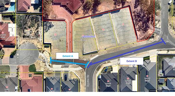
In order to create a continuous section of road Administration investigated the possibility of removing the Mossfiel Retreat cul-de-sac. This idea was not considered as an option for the City to pursue. The reason why is due to the City’s knowledge on the origins of the Mossfiel Retreat cul-de-sac, and known expectations of adjacent property owners. The adjacent property owners do not want the cul-de-sac to be removed.
The land occupied by Mossfiel Retreat was not subdivided by one continuous subdivision. Instead two subdivisions were used, and were separated by many years. Mossfiel Retreat’s cul-de-sac was created at the conclusion of the first subdivision, but never removed when the second subdivision occurred beyond the cul-de-sac.
Mossfiel Retreat is one of four examples of streets in Landsdale that end in a cul-de-sac, but have not been made continuous when land was subdivided beyond the cul-de-sacs. The other examples are Rosebud Court, Grayswood Court, and Strathpine Court. When subdivision occurred beyond these street’s cul-de-sacs, their cul-de-sacs were not removed. This was done so they remained to control traffic.
In respect to the four other streets ending in cul-de-sacs Administration is not making any recommendations. The reason why is, Administration has apprised each of the four streets individually, so to ascertain if they present the City issues similar to those discussed in this report. No issues could be identified.
Consultation
In order to resolve the issues created by the cul-de-sac Administration completed consultation with owners of affected property owners. The consultation was completed using two sets of letters addressed to the property owners.
The first letter was sent on 20 April to property owners detailing an initial plan, of only extending Zappeion Entrance to Babylon Bend, and ensuring this extension included naming of the section of road highlighted in Figure 1 as Zappeion Entrance. The City received feedback from two property owners. The feedback received was not in favour of the initial plan as they desired to have named separately, the section of road marked as Extent A in Figure 1.
Within WA the Geographic Naming Committee (GNC) has governance for naming of roads. It was consulted to discover if it were possible to separately name the section of road marked as Extent A in Figure 1. The GNC agreed that it was possible, but stipulated that the renamed section of road must be no longer than six characters in length as it is a short section of road. It should be noted that renaming is specified under AS/NZS 4819/2011 (para. 4.6.2) when a road is rendered non-continuous by road redesign or redevelopment.
Section 3.16.1 of the GNC policy for naming of geographic features requires consultation to be completed with those members of the community who are within the immediate area which will be directly affected by a proposed renaming of a section of road. Administration successfully completed this consultation in a second letter to property owners dated 23 June. The consultation involved discussion in written letters to property owners the following plan.
1. Rename that portion of Mossfiel Retreat extending west from the current junction with Zappeion Entrance as far as the cul-de-sac (‘Extent A’ in Figure 1) using a name no longer than six characters;
2. Suggesting that the section of road ought to be renamed as Nymans Close.
3. Extend Zappeion Entrance to incorporate that portion of Mossfiel Retreat extending east from their current junction to Babylon Bend (‘Extent B’ in Figure 1); and
4. Reallocate street addressing to the affected properties (Table 1).
|
Table 1: Proposed Street Addressing |
||
|
Legal Description |
Existing Address |
Proposed Address |
|
Lot: 803 DP: 73295 |
40 Mossfiel RT |
3 Nymans Close |
|
Lot: 804 DP: 73295 |
42 Mossfiel RT |
1 Nymans Close |
|
Lot: 846 DP: 73295 |
46 Mossfiel RT |
46 Zappeion Entrance |
|
Lot: 847 DP: 73295 |
48 Mossfiel RT |
48 Zappeion Entrance |
|
Lot: 848 DP: 73295 |
50 Mossfiel RT |
50 Zappeion Entrance |
|
Lot 868 DP: 404010 |
None (New Lot) |
6 Nymans Close |
|
Lot 867 DP: 404011 |
None (New Lot) |
2 Nymans Close |
|
Lot 866 DP: 404012 |
None (New Lot) |
51 Zappeion Entrance |
|
Lot 865 DP: 404013 |
None (New Lot) |
53 Zappeion Entrance |
|
Lot 9000 DP: 404010 |
49 Mossfiel RT |
4 Nymans Close |
Unlike the first of consultation with property owners, the second round did not result in any objections from property owners. Based on the absence of any negative feedback from property owners from the second round of consultation, Administration assume property owners have no issues with the proposed plan.
The City has a registry of reserved road names, pre-approved by the GNC, ready for use for resolution of issues similar to that discussed in this document. The Administration recommended to the property owners naming the section of road highlighted as Extent A in Figure 1 as ‘Nymans Close’. The proposed name is not from the register, it is one chosen by Administration. This has been required as register does not contain any six letter names relevant to famous gardens.
Use of the name ‘Nymans’ is appropriate. It makes use of the theme adopted for naming both Mossfiel Retreat and Zappeion Entrance. The theme used for their naming was ‘Famous Gardens of the World’. Having the section of road marked as Extent A in Figure 1, named as Nymans Close, will ensure that the new name will be in keeping with the practice used for naming adjacent roads.
Nymans is the name for an English country estate and its garden -
“In the late 1800s Ludwig Messel bought the Nymans Estate in the Sussex High Weald to make a dream family house. Inspired by the wooded surroundings he created a garden with plants collected from around the world. Here this creative family entertained friends and family, enjoyed relaxing, playing and picnicking in the garden and woods. Today it is still a garden lovers' home - a place to relax all year round and enjoy a peaceful country garden.”
Comment
Under the Local Government Act 1995 the City is responsible for street addressing. Ensuring that the City maintains a consistent standard of unambiguous street addressing aids emergency services, other service providers and the property owners, and supports the City in meeting its duty of care obligations to all stakeholders.
The City investigated a number of options to assist in alleviating the issues created by the cul-de-sac. Other options that were considered included retaining the status quo, or not creating an entirely new name for the discontinuous section of Mossfiel Retreat, but extending Zappeion Entrance to Babylon Bend.
Of all options available Administration favoured the Proposed Plan. This preference is based upon:
· The Proposed Plan allowing for properties along the affected road extents to be addressed clearly, unambiguously and in a manner consistent with the relevant standard;
· The Proposed Plan affecting a minimal number of properties;
· The documented support of GNC;
· The support of those affected property owners who participated in the consultation exercise.
Statutory Compliance
Nil
Strategic Implications
The proposal aligns with the following objective within the Strategic Community Plan 2013 – 2023:
“4 Civic Leadership - Working with others to ensure the best use of our resources.
4.2 Working With Others - The community is a desirable place to live and work as the City works with others to deliver the most appropriate outcomes.”
Risk Management Considerations
|
Risk Title |
Risk Rating |
|
Productive Communities |
Moderate |
|
Accountability |
Action Planning Option |
|
Director Community Development |
Manage |
|
Risk Title |
Risk Rating |
|
Integrated Infrastructure and Utility Planning |
Moderate |
|
Accountability |
Action Planning Option |
|
Executive Management Team (Director Planning & Sustainability and Director Infrastructure) |
Manage |
The above listed risks have been identified and considered within the City’s Strategic Risk Register. Action Plans have been developed to manage this risk to improve the existing management systems.
Policy Implications
Nil
Financial Implications
1. For owners of Lots 803 and 804, the City allowing for each, $100 for new letter box street address numbers; and
2. The City would need to purchase a new road sign named Nymans Close, for Extent A identified in Figure 1. This cost will be borne by the Infrastructure Directorate’s operational budget for road signage. Costs have been estimated to be $200.
Voting Requirements
Simple Majority
That Council APPROVES to extend Zappeion Entrance to Babylon Bend, and rename that portion of Mossfiel Retreat extending west from its current junction with Zappeion Entrance into the cul-de-sac to ‘Nymans Close’ and reallocate street addressing to affected properties.
CITY OF WANNEROO Agenda OF Elected Members' Briefing Session 06 October, 2015 450
Other Matters
File Ref: 21762 – 15/481977
Responsible Officer: Director Corporate Strategy and Performance
Disclosure of Interest: Nil
Attachments: Nil
Issue
To consider the Audit & Risk Committee’s recommendation to accept Tender No. 01527 from William Buck Consulting (WA) Pty Ltd for the provision of Internal Audit Services (Services) for an initial period of 33 months with two (2) twelve month options to extend.
Background
The current Services contract with KPMG commenced on 1 October 2011 for an initial period of three years and expired on 30 September 2014. A twelve month extension of the contract was approved by Council at its meeting of 16 September 2014. The current contract (including the extension period) with KPMG expired on 30 September 2015.
On 10 March 2015, Administration informed the Audit & Risk Committee of its intention to call for public tenders prior to the expiration of the current Services contract.
Details of the considerations including proposed areas for future audits in developing the scope and selection criteria for the proposed tender were provided to the Audit & Risk Committee on 15 April 2015.
Detail
Tender No. 01527 for the provision of Services was advertised on 6 June 2015 and closed on 23 June 2015.
At the close of tender, the following firms had submitted tenders:
· William Buck Consulting (WA) Pty Ltd;
· UHY Haines Norton (WA);
· BDO;
· Crowe Horwath;
· KPMG;
· Protiviti; and
· Walker Wayland Audit.
The Tender Evaluation Team (TET) comprising of Manager Governance & Legal, Manager Risk & Business Improvement, Manager Property Services, Coordinator Enterprise Risk Management and Audit & Assurance Officer with oversight by the Contracts Officer, assessed each of the tenders in accordance with the following evaluation criteria:
· Price for Services offered – 20%;
· Demonstrated relevant experience, capability and past performance – 40%;
· Plan for proposed services including proposed work-plan, methodology, personnel, resourcing and team structure – 35%; and
· OSH – 5%.
A weighted scoring matrix was applied to determine the overall ranking of the tenders.
Tender’s price for services offered – 20%
Tenderers were requested to submit work hours based on their own estimation as to what is required to complete full scope internal audits, including the anticipated involvement of each level of nominated personnel and an hourly rate for each nominated personnel to undertake the proposed Services. Considering that most of the tenderers applied Administration’s indicative hours set out in the tender documentation as a reasonable starting point on their price schedule, the blended hourly rate offered by each tenderer was applied to determine the overall ranking for this evaluation criterion.
The ranking of tenders on the basis of the tendered blended hourly rate are as follows:
|
Tenderer |
Blended Hourly Rate $ |
Ranking |
|
Crowe Horwath |
122 |
1 |
|
BDO |
124 |
2 |
|
William Buck Consulting (WA) Pty Ltd |
125 |
3 |
|
KPMG |
140 |
4 |
|
Protiviti |
150 |
5 |
|
UHY Haines Norton (WA) Pty Ltd |
200 |
6 |
|
Walker Wayland (WA) Pty Ltd |
341 |
7 |
Demonstrated relevant experience, capability and past experience – 40%
Each of the tenderer’s relevant experience (as set out in their respective tender) was assessed in order to evaluate their ability and capability to meet the requirements of the scope for the Services. Assessment of this criterion considered each of the tenderer’s previous and current experience in respect to the scoped Services and experience in providing similar audit services.
The TET determined that the tenderers demonstrated various levels of relevant experience in undertaking the Services including similar audit services across numerous sectors, significantly large corporate organisations, State Government departments and Local Governments across Australia including in Western Australia.
The assessment resulted in a ranking for evaluation of this criterion as follows:
|
Tenderer |
Ranking |
|
Protiviti |
1 |
|
KPMG |
1 |
|
William Buck Consulting (WA) Pty Ltd |
3 |
|
Crowe Horwath |
4 |
|
BDO |
5 |
|
UHY Haines Norton (WA) Pty Ltd |
5 |
|
Walker Wayland (WA) Pty Ltd |
7 |
In respect of this criterion the top three ranked tenders were very closely ranked and in evaluating the respective tenders, the TET considered that:
· Protiviti:
o has experience providing the Services for numerous State Government departments in Western Australia;
o provides similar audit services to two universities in Western Australia;
o provides similar audit services to numerous Commonwealth Government departments; and
o has key personnel who hold positions on the Audit Committees of other Local Governments in Western Australia including the Cities of Perth and Stirling.
· KPMG:
o has extensive experience in providing similar audit services to numerous local governments in South Australia, Queensland, News South Wales and Victoria but only provided the Services to one local government in Western Australia (City of Wanneroo);
o has experience in developing Integrated Reporting Frameworks and business plans for other Local Governments in Western Australia;
o provides similar audit services for organisations across a range of sectors and industries including numerous State Government departments across Australia including in Western Australia; and
o is the City’s incumbent contracted internal auditor and has been for the last 4 years.
· William Buck Consulting:
o has extensive experience providing the Services for other Local Governments in Western Australia, including the Cities of Fremantle and Swan;
o has experience providing the Services and other similar audit services for a number of State Government departments in Western Australia including Landgate, Western Power and the Disability Services Commission; and
o has limited experience in providing similar audit services for the private sector or in jurisdictions outside of Western Australia.
Plan for proposed services including proposed work-plan, methodology, personnel, resourcing and team structure – 35%
Each of the tenderer’s resources (as set out in their respective tender) was assessed in order to evaluate their capacity to provide the scoped Services. Assessment of this criterion considered the tenderers’ team structure, in particular the anticipated involvement of the nominated personnel and the level of experience of the nominated personnel and resources including continuing availability of resources. Proposed work-plan and methodology including communication plan, quality assurance and proposed deliverables were also assessed as part of this criterion.
A review of the documentation submitted showed the tenderers have various levels of resources available to service the contract and the experiences of the resources were also considered. Further consideration was given to the fact that the proposed deliverables should include unbranded working papers as this will add value to the City in the long term in implementing a rolling internal audit program as guided by the Control Assurance Framework which is under development. This resulted in a ranking as follows:
|
Tenderer |
Ranking |
|
William Buck Consulting (WA) Pty Ltd |
1 |
|
Protiviti |
2 |
|
KPMG |
3 |
|
Crowe Horwath |
4 |
|
BDO |
5 |
|
UHY Haines Norton (WA) Pty Ltd |
5 |
|
Walker Wayland (WA) Pty Ltd |
7 |
OSH – 5%
Each of the tenderer’s resources (as set out in their respective tender) was assessed in order to evaluate their OSH management plan and compliance with the OSH requirements of the tender. Assessment of this criterion considered the tenderers’ responses to the OSH management questionnaire resulting in a ranking as follows:
|
Tenderer |
Ranking |
|
Protiviti |
1 |
|
KPMG |
1 |
|
Crowe Horwath |
1 |
|
BDO |
1 |
|
William Buck Consulting (WA) Pty Ltd |
5 |
|
UHY Haines Norton (WA) Pty Ltd |
5 |
|
Walker Wayland (WA) Pty Ltd |
7 |
Overall Ranking based on Evaluation Criteria
The total weighted scores resulted in the following overall ranking of the tenderers:
|
Tenderer |
Score out of 100 |
Ranking |
|
Protiviti |
75 |
1 |
|
KPMG |
74 |
2 |
|
William Buck Consulting (WA) Pty Ltd |
74 |
2 |
|
Crowe Horwath |
68 |
4 |
|
BDO |
63 |
5 |
|
UHY Haines Norton (WA) Pty Ltd |
55 |
6 |
|
Walker Wayland (WA) Pty Ltd |
30 |
7 |
Given the extremely close overall weighted scores of the three top ranked tenderers (Protiviti, KPMG and William Buck Consulting), the TET determined to shortlist these three tenderers for a presentation interview session to provide the tenderers an opportunity to further clarify certain information in respect of their tender submissions. The presentation and interview sessions were conducted on 27 July 2015 and each of the three tenderers provided further clarification on specific issues in respect of the:
· identified and requested deliverables against proposed internal audits; and
· estimated hours proposed by each tenderer to complete the scope of each identified internal audit.
The outcome of the presentation interview sessions and the final overall ranking of the tenders are set out below.
Presentation and Interview Session
The following questions were prepared by the TET and provided to the three shortlisted tenders on the Thursday prior to the presentation and interview session on Monday 27 July 2015 (Presentation and Interview Session):
|
Question Number |
Questions |
Details |
|
1 |
Please provide specific details in respect of the deliverables against each internal audit.
|
· A list of deliverables and specific details · How do you intend to scope this out in your work plan? · Will editable soft copies of working papers be available for the Principal? |
|
Question Number |
Questions |
Details |
|
2 |
Please confirm that the Estimated Total Hours set out in the Price Schedule is based on your own estimation as to what is required to complete full scope internal audits? If not, please amend the Estimated Total Hours in the Price Schedule and submit this to the Principal. |
The full scope of internal audit should cover an internal audit process from risk assessment, audit plan, fieldwork (including effective sample testing and validation procedures undertaken), reporting to follow-up of recommendations. |
Overall Final Ranking
The TET assessed each of the three shortlisted tenderers’ responses and considered the impact of those responses in determining a final overall ranking and recommendation. The critical considerations for the each of the shortlists tenderers are as follows:
KPMG
The TET determined that the initial ranking attributed to KPMG was negatively impacted in comparison to Protiviti and William Buck Consulting because KPMG:
· confirmed that the working paper deliverables would not be provided in editable format; and
· the estimated total hours for each of the identified internal audits were significantly more than the estimated hours set out in the tender document and as these hours are charged at the blended hourly rate, the contract expenditure would be significantly more than budgeted.
Protiviti
The TET determined that the initial ranking attributed to Protiviti did not improve in comparison to William Buck Consulting considering that Protiviti confirmed that:
· detailed working paper deliverables will be provided in editable formats as requested; and
· whilst the estimated total hours for each of the identified internal audits was accepted, the estimated total hours would be subject to discussion and agreement on specific scope and objectives.
William Buck Consulting
The TET determined that the initial ranking attributed to William Buck Consulting improved in comparison to both KPMG and Protiviti because William Buck Consulting:
· will provide all detailed working paper deliverables in editable format;
· provided examples of working papers and reports for review; and
· confirmed that based on William Buck Consulting’s experience in delivering the Services to similar sized Local Governments in Western Australia, the estimated total hours for each of the identified internal audits is adequate to provide the Services and that as a general rule, William Buck Consulting does not seek to invoice more hours that are allocated to an internal audit.
On the basis of the further assessment undertaken and subsequent impact on the initial rankings for the shortlisted tenderers, the TET determined that the preferred tenderer is William Buck Consulting with the overall final ranking as follows:
|
Tenderer |
Ranking |
|
William Buck Consulting (WA) Pty Ltd |
1 |
|
Protiviti |
2 |
|
KPMG |
3 |
Consultation
Administration consulted with the Contracts and Procurement Team in the preparation of and in undertaking this tender.
As William Buck Consulting and Protiviti were ranked overall 1 and 2 respectively both tenderers were invited to attend the Audit & Risk Committee meeting on 25 August 2015 to provide a short presentation and addressed queries of the Audit & Risk Committee.
Comment
The City currently has capacity to conduct internal audits either in-house or via external contract for the Services. There are significant benefits for the City to continue to contract with an external provider as the City’s in-house resource only has limited capacity to evaluate and improve the effectiveness of risk management, control and governance processes across the City. Developing and maintaining a strong relationship with an internal audit service provider would assist in building in-house expertise and improve capacity for the City in delivering the Services and improved internal control programs.
Preferred Tenderer
William Buck Consulting ranked the highest overall as they have extensive experience in undertaking audits for local government clients in Western Australia, including a number of local governments of significant size such as City of Joondalup, City of Stirling, City of Swan and City of Fremantle. William Buck Consulting has also conducted audits of similar nature within the proposed audit plan that was provided in their tender submission across various other local governments.
Administration undertook a reference check of three of William Buck Consulting’s current clients that included the City of Joondalup, the City of Fremantle and the Southern Metropolitan Regional Council. Each reference indicated that William Buck Consulting:
· is a professional auditor;
· provides a diligent service;
· maintains a stable knowledgeable team;
· communicates well in particular when presenting at Audit & Risk Committee meetings; and
· works within predetermined budgets and does not bill for variations.
None of the referees identified any negative issues with William Buck Consulting or the services they provided. The City of Fremantle confirmed that their contract with William Buck Consulting has just been renewed.
In addition, William Buck Consulting were very clear on the deliverables that the City is seeking and had no issue with providing editable soft copies of working papers to the City for any audits conducted including but not limited to risk and control matrices, sample testing documentation and business process flowcharts if required. Administration considers the provision of editable soft copy working papers as a critical deliverable as this will add significant value to the City’s internal audit function and will avoid unnecessary increase in the City’s work load when conducting update control testing as part of the City’s future control assurance framework. An additional benefit is that this will also transfer internal audit knowledge from the service provider to Administration.
Based on their extensive experience in delivering similar internal audits across other Western Australian local governments and state government clients, William Buck Consulting confirmed that the estimated total hours estimated by Administration was both realistic and adequate to deliver the proposed internal audit services. William Buck Consulting have further indicated from their experience that across the internal audit plan there may be instances where there is an excess and some reviews with a shortage of hours, which can be reallocated with no overall increase in cost. Further, William Buck Consulting confirmed that as a general rule that they do not seek to invoice more hours for an audit than what was allocated.
The representatives from William Buck Consulting presented their answers in a succinct manner and appeared professional during the Presentation and Interview Session. In addition to the responses requested by the TET, they provided a copy of their standard reporting template and have committed that they would accommodate and amend any of their standard formats to meet any further requirements that the City may have.
The Audit & Risk Committee at its meeting on 22 September 2015 recommended that Council accepts Tender No. 01527 from William Buck Consulting (WA) Pty Ltd for the provision of Internal Audit Services for an initial period of 33 months from 1 October 2015 to 30 June 2018 with the option to extend the contract for a further two (2) twelve (12) month periods at the discretion of the City.
Probity Considerations
Following feedback received from the Audit & Risk Committee at the meeting of 25 August 2015 the Chief Executive Officer determined to instigate an independent Probity Audit of the tender evaluation process that was undertaken. Administration engaged Stantons International to undertake the probity audit (Probity Audit).
Notwithstanding that the Probity Audit identified a few deviations from best practice in respect of the evaluation process undertaken by the TET, the findings of the Probity Audit confirms that the overall outcome of the evaluation process is both technically correct and an appropriate outcome.
Statutory Compliance
Tenders were invited in accordance with the requirements of Section 3.57 of the Local Government Act 1995. The tendering procedures and evaluation complied with the requirements of Part 4 of the Local Government (Functions and General) Regulations 1996.
Whilst there is no statutory requirement for an external contract for the Services, the Audit Regulations 1996 prescribe for the regular review of the effectiveness of systems and processes relating to risk, internal controls and legislative compliance. The use of a mixed service delivery model will provide the City with the capacity to achieve this.
Strategic Implications
The proposal aligns with the following objective within the Strategic Community Plan 2013 – 2023:
“4 Civic Leadership - Working with others to ensure the best use of our resources.
4.3 A Strong and Progressive Organisation - You will recognise the hard work and professionalism delivered by your council through your interactions and how our community is developing.”
Risk Management Considerations
There are no Strategic or Corporate risk considerations in respect of this report.
Sustainability Implications
Nil
Policy Implications
Tenders were invited in accordance with the City’s Purchasing Policy.
Financial Implications
The cost to the City for the Services is within the amount provided for in the City’s operating budget for the Services.
A financial assessment of William Buck Consulting was undertaken and indicated a sound financial rating. The company is trading in a profitable manner and the size of its annual revenue indicates that the contract for the Services is within its financial capacity.
Voting Requirements
Simple Majority
That Council ACCEPTS the recommendation of the Audit & Risk Committee and ACCEPTS Tender No. 01527 from William Buck Consulting (WA) Pty Ltd for the provision of Internal Audit Services for an initial period of 33 months from 1 October 2015 to 30 June 2018 with the option to extend the contract for a further two (2) twelve (12) month periods at the discretion of the City.
Attachments: Nil
CITY OF WANNEROO Agenda OF Elected Members' Briefing Session 06 October, 2015 459
Chief Executive Office
Item 5 Late Reports (to be circulated under separate cover)
File Ref: 14437 – 15/436774
Responsible Officer: Director Corporate Strategy and Performance
This report is to be dealt with in confidential session, under the terms of the Local Government Act 1995 Section 5.23(2), as follows:
(b) the personal affairs of any person
(c) a contract entered into, or which may be entered into, by the local government and which relates to a matter to be discussed at the meeting
(d) legal advice obtained, or which may be obtained, by the local government and which relates to a matter to be discussed at the meeting
The next Ordinary Council meeting has been scheduled for 7:00pm on Tuesday 13 October 2015, to be held at Council Chambers, Civic Centre.